| فلسطين في الذاكرة | من نحن | تاريخ شفوي | نهب فلسطين | English |
| الصراع للمبتدئين | دليل العودة | صور | خرائط |
| فلسطين في الذاكرة | سجل | تبرع | أفلام | نهب فلسطين | إبحث | بيت كل الفلسطينيين على الإنترنت | English | |
| من نحن | الصراع للمبتدئين | صور | خرائط | دليل حق العودة | تاريخ شفوي | نظرة القمر الصناعي | أعضاء الموقع | إتصل بنا |
| إبحث |
| أريحا |
| بئر السبع |
| بيت لحم |
| بيسان |
| جنين |
| حيفا |
| الخليل |
| رام الله |
| الرملة |
| صفد |
| طبريا |
| طولكرم |
| عكا |
| غزة |
| القدس |
| نابلس |
| الناصرة |
| يافا |
| تبرع |
| سجل |
| إتصل بنا |
| فديوهات |
|
السابقة |
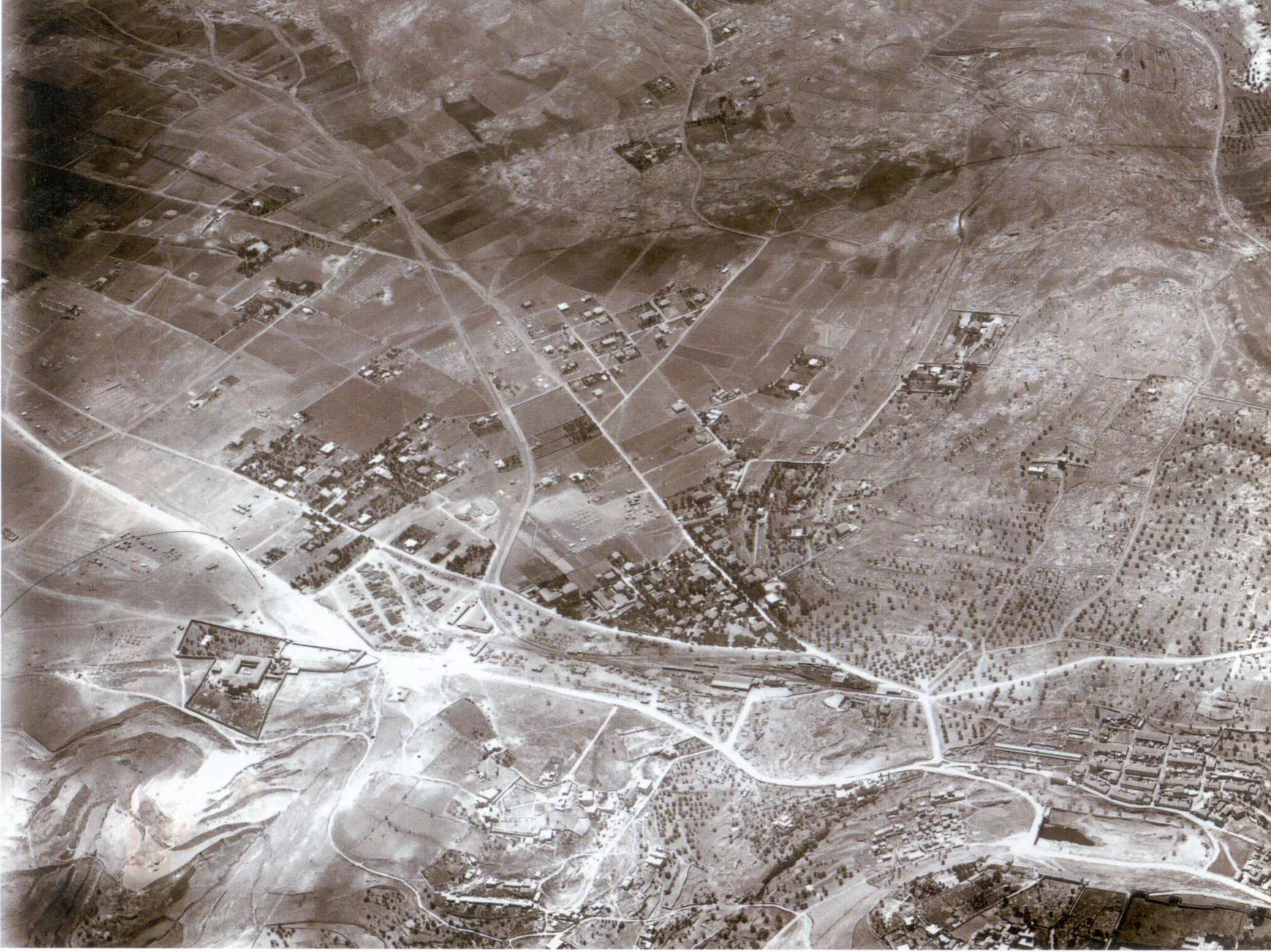
القدس الشريف: منظر نادر من الجو للاحياء الجنوبية للمدينة سنة 1918. الجهة اليمنى من الصورة تشير نحو الاتجاه الشمالي. اُنقر الصورة لتكبيرها.3 تعليقات |
التالية
English |
| رُفعت في19 كانون أول، 2006 |
||
| شارك | السابقة 738 739 740 741 742 التالية | القمر الصناعي |

الجديد في الموقع
- لماذا رفع اليهود الصهاينة أعلام الصليب المعقوف النازية على سفنهم في الثلاثينيات؟

- طوفان الاقصى: حقائق عن الغارة التي شنها المقاومون الفلسطينيون من غزة يوم 7 أوكتوبر عام 2023
- فديو: كيف تستخدم الموقع
- تنويه: الآن كل صور الموقع باتت مُصنفة حسب الموضوع
- تغير بنشر جيب الاحتلال من قبل مدير شرطة الخليل أحمد ابوالرب هو تجسيد لكل صفقة اسلو الخيانة
- كتابي بلادنا فلسطين لمصطفي الدباغ والنكبة الفلسطينية لعارف العارف، كل صفحاتهم (الإثني عشر الف صفحة) متوفرة من خلال الموقع
- محمود عباس: ارجوك لا تتحدث باسمنا -- عبد الباري عطوان
- أكبر وأشمل توثيق خرائطي إلكتروني لفلسطين عبر القمر الصناعي
- حملة ضد القمل
- بثت قناة الجزيرة الفضائية مقطع عن موقع فلسطين في الذاكرة ومشروعها التاريخ الشفوي للنكبة الفلسطينية
- مقال رائع كتب عن فلسطين في الذاكرة في جريدة الدستور الأردنية
- فك طوق الأسر عن اهل غزة
- مشروع التاريخ الشفوي للنكبة الفلسطينية: أكثر من 600 مقابلة مع لاجئين شهدوا النكبة تحتوي على أكثر من 3,000 ساعة تسجيل .
- برنامج توثيق القرى المدمرة عبر الفيديو
- الصراع العربي - الإسرائيلي للمبتدئين
- أفلام تخص فلسطين، تاريخها وتراثها
- دليل حق العودة - القراءة ضرورية لكل فلسطيني
- تسلسل زمني للتاريخ الفلسطيني
شارك بتعليقك
Shimon from israel