| PalestineRemembered | About Us | Oral History | العربية | |
| Pictures | Zionist FAQs | Haavara | Maps | |
| Search |
| Camps |
| Districts |
| Acre |
| Baysan |
| Beersheba |
| Bethlehem |
| Gaza |
| Haifa |
| Hebron |
| Jaffa |
| Jericho |
| Jerusalem |
| Jinin |
| Nablus |
| Nazareth |
| Ramallah |
| al-Ramla |
| Safad |
| Tiberias |
| Tulkarm |
| Donate |
| Contact |
| Profile |
| Videos |
Welcome To Karatiyya - كرتيا (כרתיא)
|
District of Gaza
Ethnically cleansed days ago |
العربية Google Earth |
 |
Gallery (21) |
- Statistics & Facts
-
Before & After

- Satellite View
- Articles 1
- Pictures 21
- Aerial Views 1
- Land Deeds 12
- Oral History 2
- Members 11
- All That Remains
- Town's Map
- Wikipedia
- Videos 2
- Guest Book 11
- Links 1
| Statistic & Fact | Value | ||||||||||||||
| Occupation Date | July 17, 1948 | ||||||||||||||
| Distance From District | 29 (km) North East of Gaza | ||||||||||||||
| Elevation | 100 (meters) | ||||||||||||||
| Before & After Nakba, Click Map For Details |
|||||||||||||||
|
|||||||||||||||
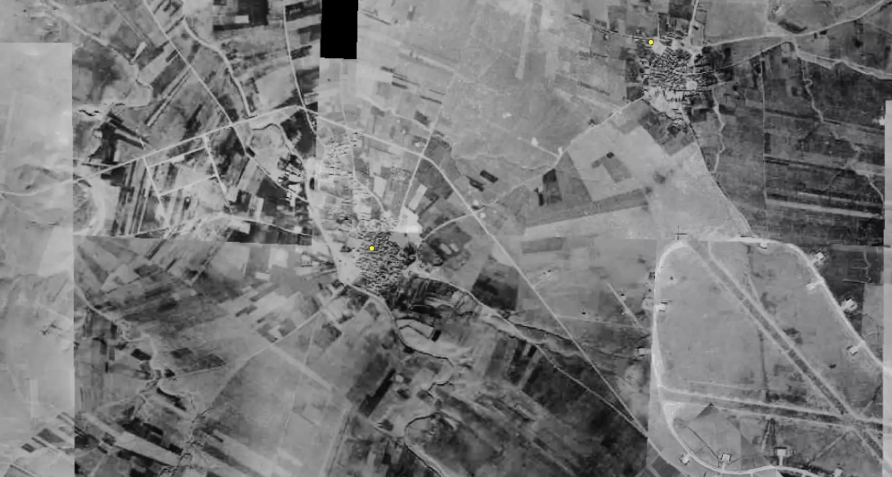
| Pre-Nakba Aerial View |
|||||||||||||||
|
|||||||||||||||
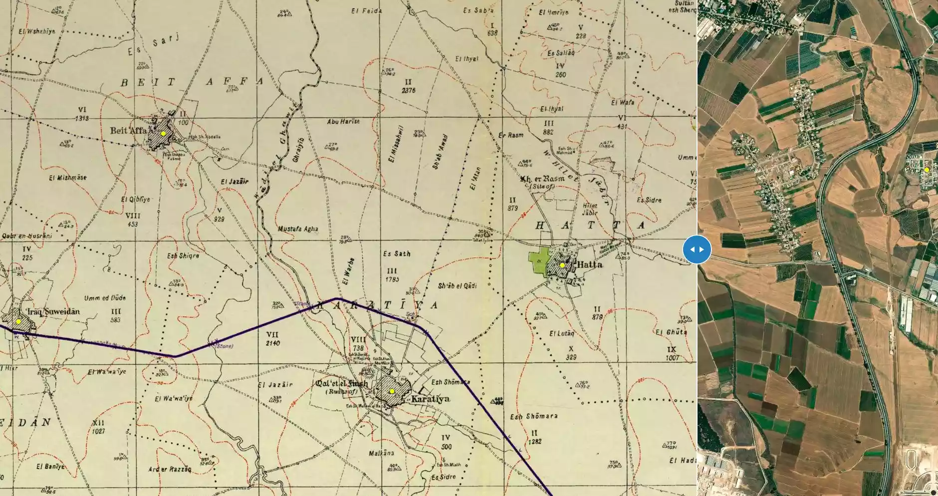
| Map Location | See location #26 on the map View from satellite |
||||||||||||||
| Military Operation | Either Operation Barak or Operation Ya'ov | ||||||||||||||
| Attacking Units | Third Battalion of the Giv'ati Brigade and the Ninth Commando Battalion of the Armored Brigade. | ||||||||||||||
| Defenders | Egyptian Army | ||||||||||||||
| Exodus Cause | Military assault by Zionist troops | ||||||||||||||
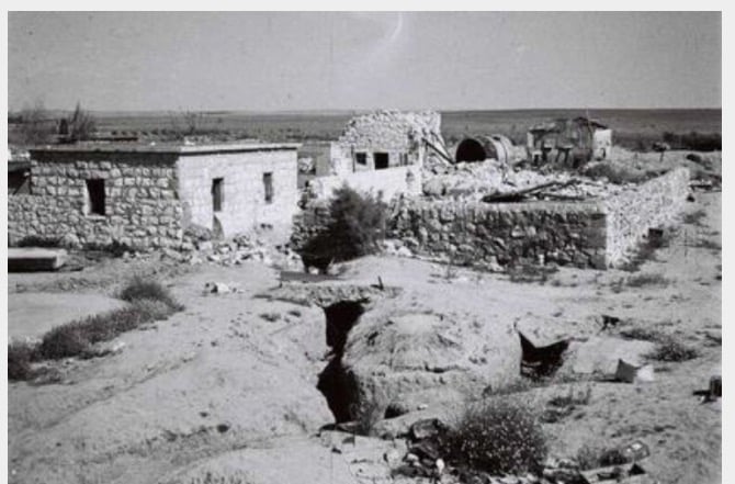
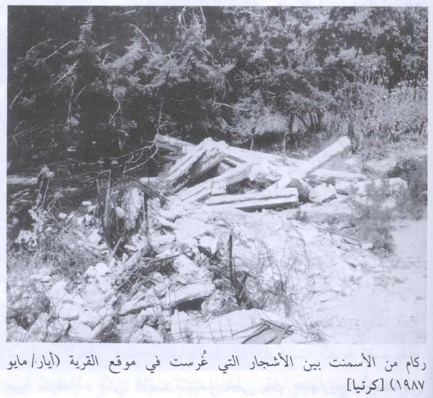
| Village Temains | The village was completely destroyed and only house rubble left behind. | ||||||||||||||
| Ethnically Cleansing | Karatiyya inhabitants were completely ethnically cleansed. | ||||||||||||||
| Pre-Nakba Land Ownership |
**Town Lands' Demarcation Maps |
||||||||||||||
| Land Usage As of 1945 |
|
||||||||||||||
| Population |
|
||||||||||||||
| Number of Houses |
|
||||||||||||||
| Near By Towns |
|||||||||||||||
|
|||||||||||||||
| Town's Name Through History | The Crusades built in Karatiyya a castle which was known by Galatie, from which it may have picked its name from. | ||||||||||||||
| Schools | Karatiyya had an elementary school for boys which was founded in 1922, and in 1945 it had an enrollment of 128 students. | ||||||||||||||
| Places of Warship | One mosque | ||||||||||||||
| Nearby Wadies & Rivers | Wadi al-Mufrid bordered the village from the east. | ||||||||||||||
| Archeological Sites | Karatiyya contained number of khirbats dating from the days of the Mamluks and the Crusades periods. | ||||||||||||||
| Exculsive Jewish Colonies That Usurped Village Lands |
Qomemiyyut, Nehora, and Rewacha. | ||||||||||||||
| Featured Video | |||||||||||||||
Village TodayAccording to the Palestinian historian Walid Khalidi, the village remaining structures on the village land are:"Piles of debris are scattered on the site, and a destroyed cemetery (partially hidden among eucalyptus trees) can be seen. An agricultural road runs through it." |
|||||||||||||||
| Related Maps | Town Lands' Demarcation Maps خرائط للقضاء توضح حدود القرى والاودية Town's map on MapQuest View from satellite Help us map this town at WikiMapia |
||||||||||||||
| Related Links | Wikipedia's Page Facebook Page Google Search Google For Images Google For Videos |
||||||||||||||
| More Information | مخطط البلد في كتاب كي لا ننسى المزيد من موقع هوية |
||||||||||||||
- Village Rubble In 1987
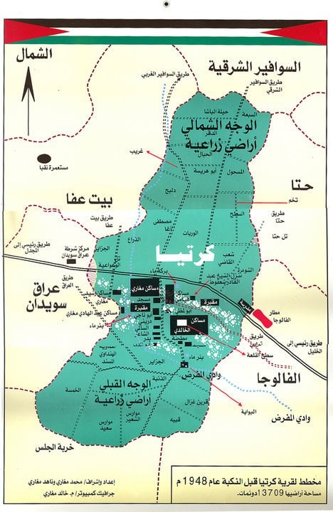
Scanned from "All That Remains" by Dr. Walid Khalidi 6 - مخطط قرية كرتيا قبل النكبة، إعداد محمد وناهد مغازي
2 - قريه كرتيا بعد احتلالها
Posted by abu raya - Pre-Nakba Aerial view of the village / صورة من الجو للقرية اخذت قبل النكبة
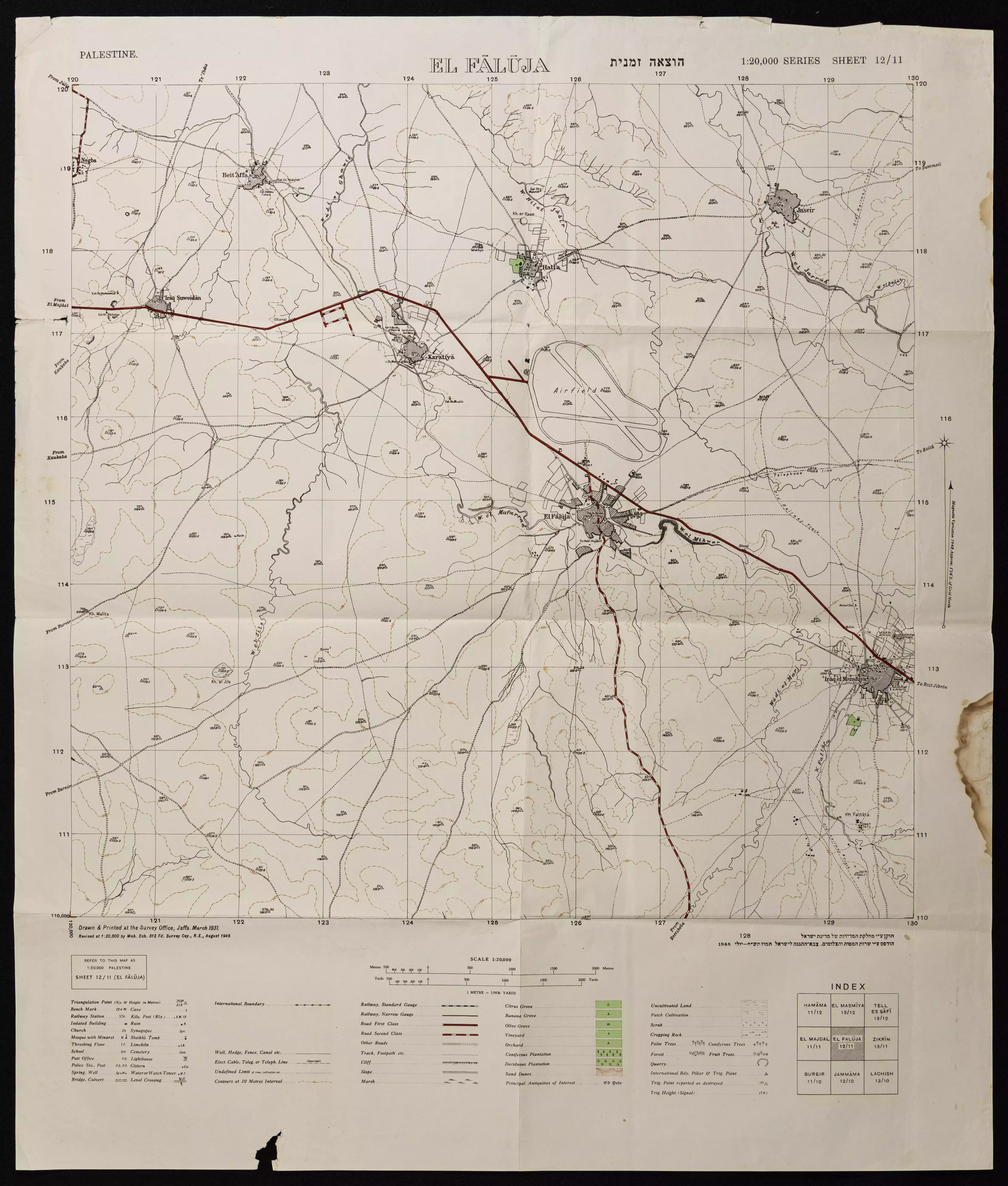
- خارطة تُظهِر الحدود والطرق بأنواعها والأماكن المقدسة والطبيعة الطوبغرافية من تلال وسهول ومنحدرات والتشكيلة الطبيعية للأرض وأنواع المزروعات. نُشرت الخريطة فترة الانتداب البريطاني، تم إضافة تعديلات عليها من قِبَل خدمة الخرائط والصور التابعة للقوات العسكرية الاسرائيلية فترة الأربعينيات.
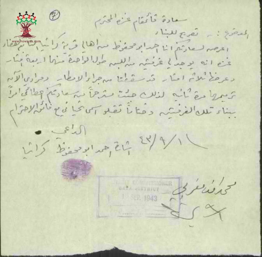
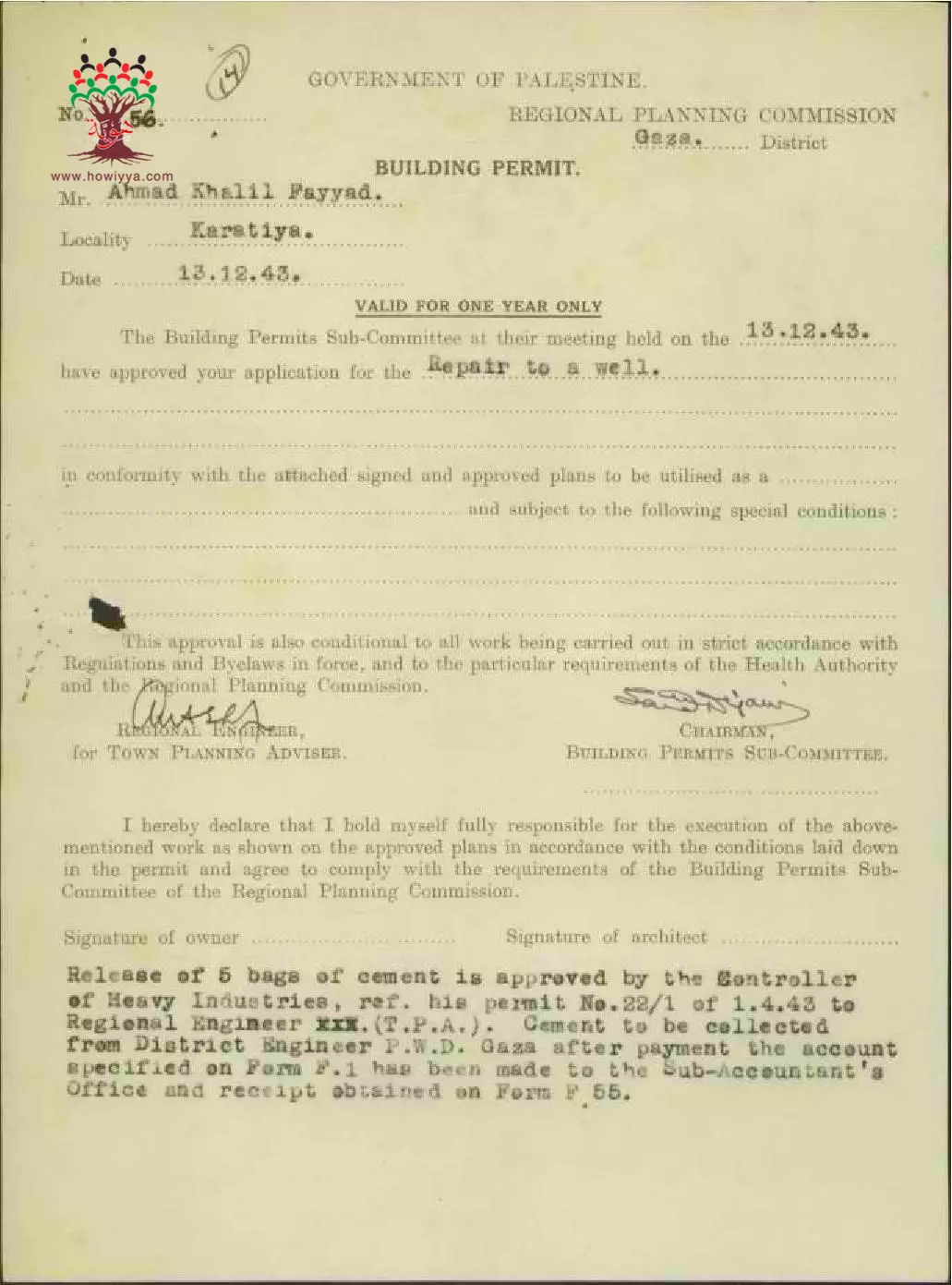
- طلب رخصة بناء للمواطن أحمد أبو محفوظ-كرتيا
-تاريخ الوثيقة: 01/09/1943
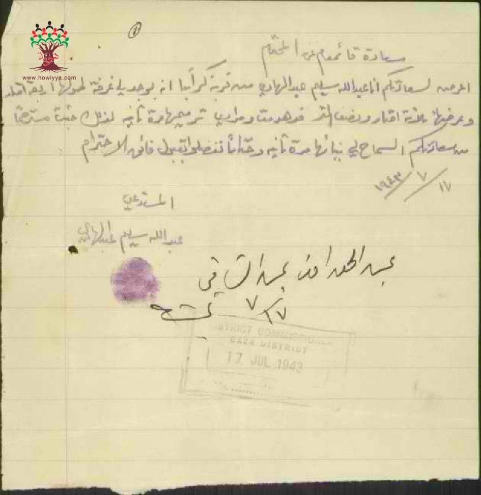
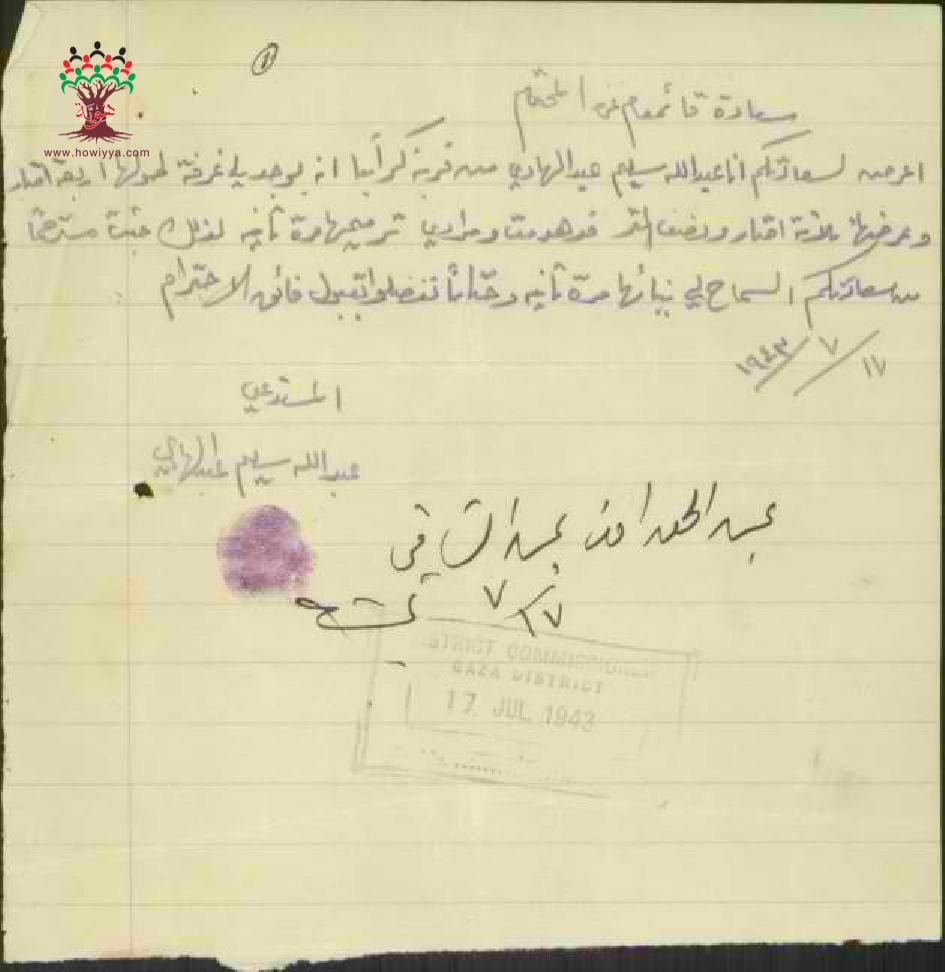
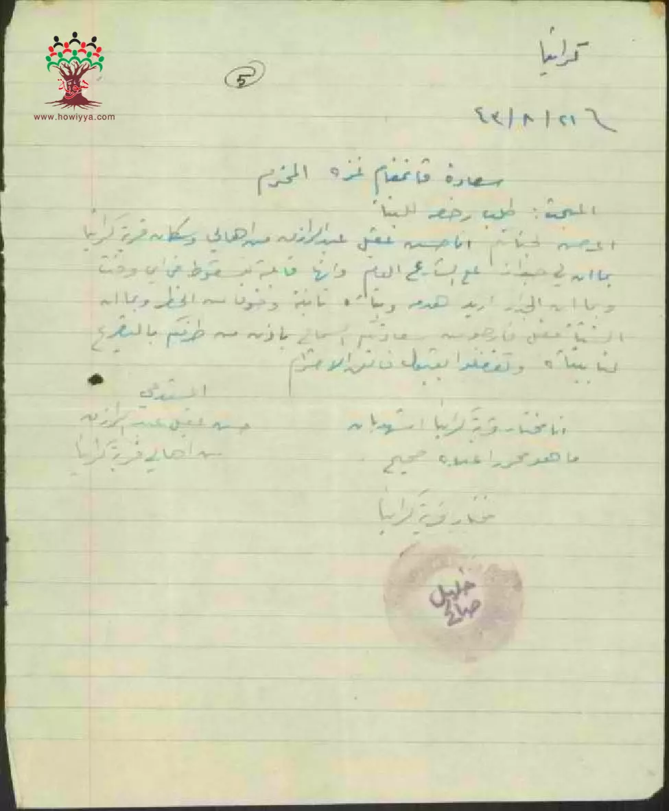
- رسالة من عبد الله سليم عبد الهادي الى قائمقام غزة بخصوص طلب ترميم غرفة طولها 4 امتار
-تاريخ الوثيقة:
17/07/1943
-
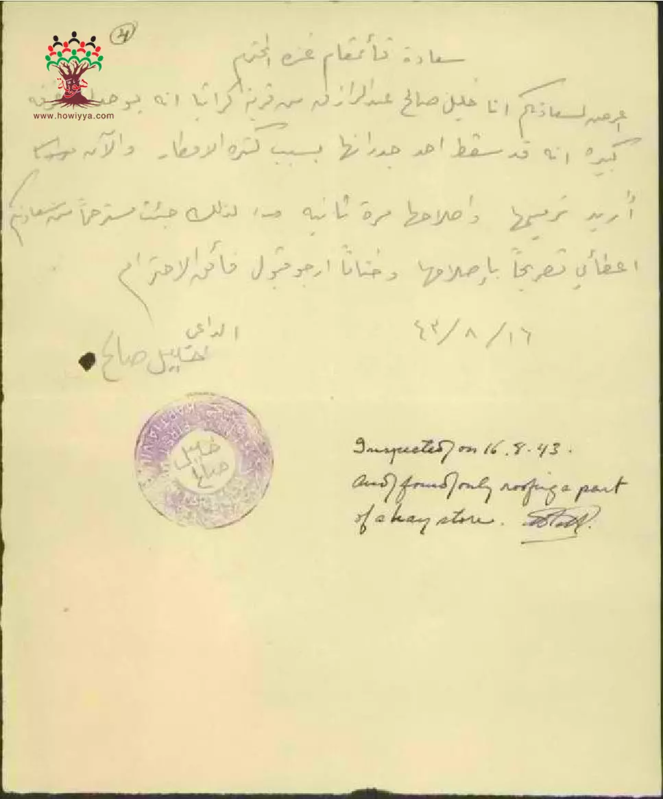
طلب رخصة بناء ل خليل صالح-كرتيا --16/08/1943
-
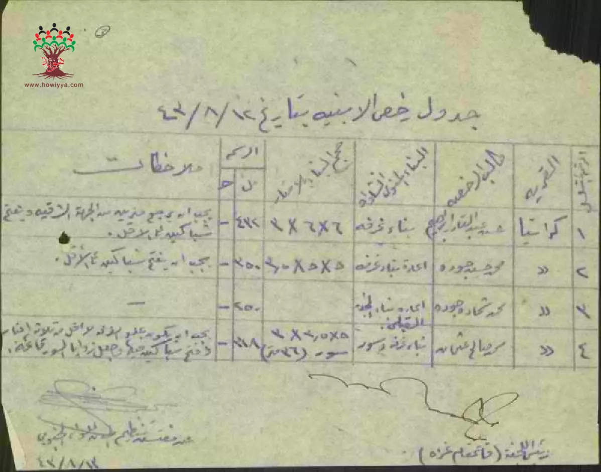
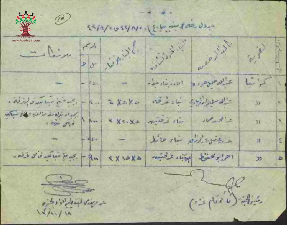
جدول رخص بناء في كرتيا بتاريخ 12-8-1943
-
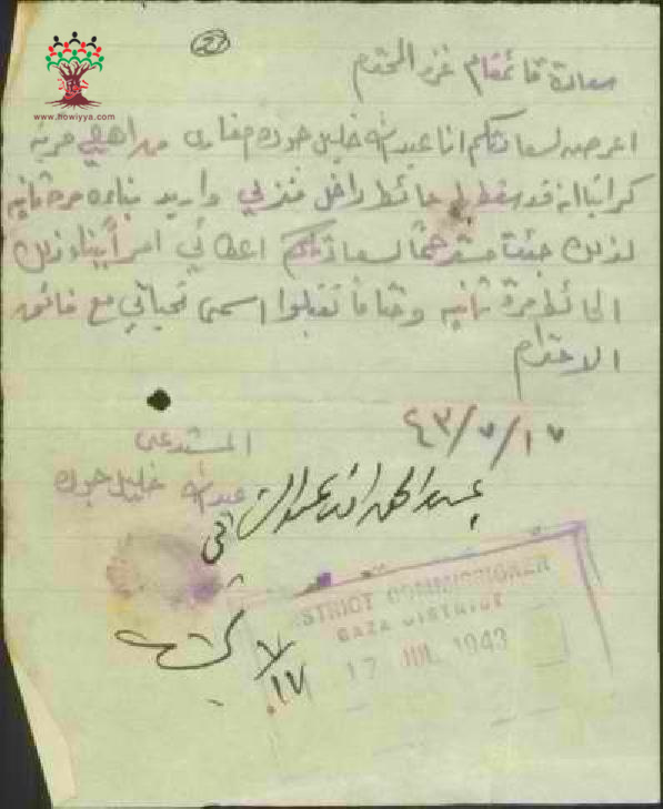
طلب رخصة بناء ل عبد الله خليل جوك-كرتيا -- 17/07/1943
-
طلب رخصة بناء ل عبد الله سليم عبد الهادي-كرتيا -- 17/07/1943
-
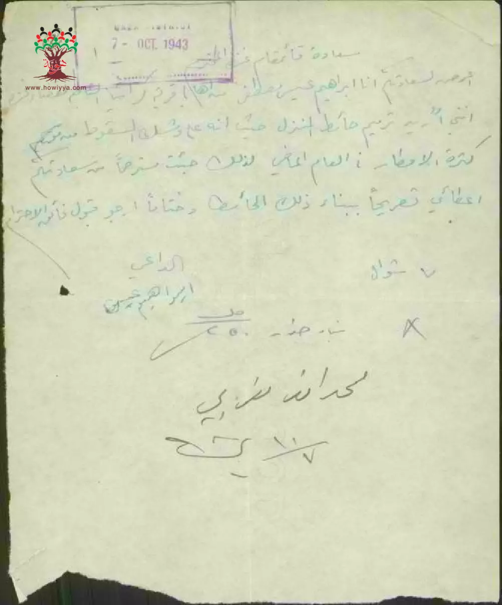
طلب رخصة ترميم ل ابراهيم عيسى-كرتيا -- 07/10/1943
-
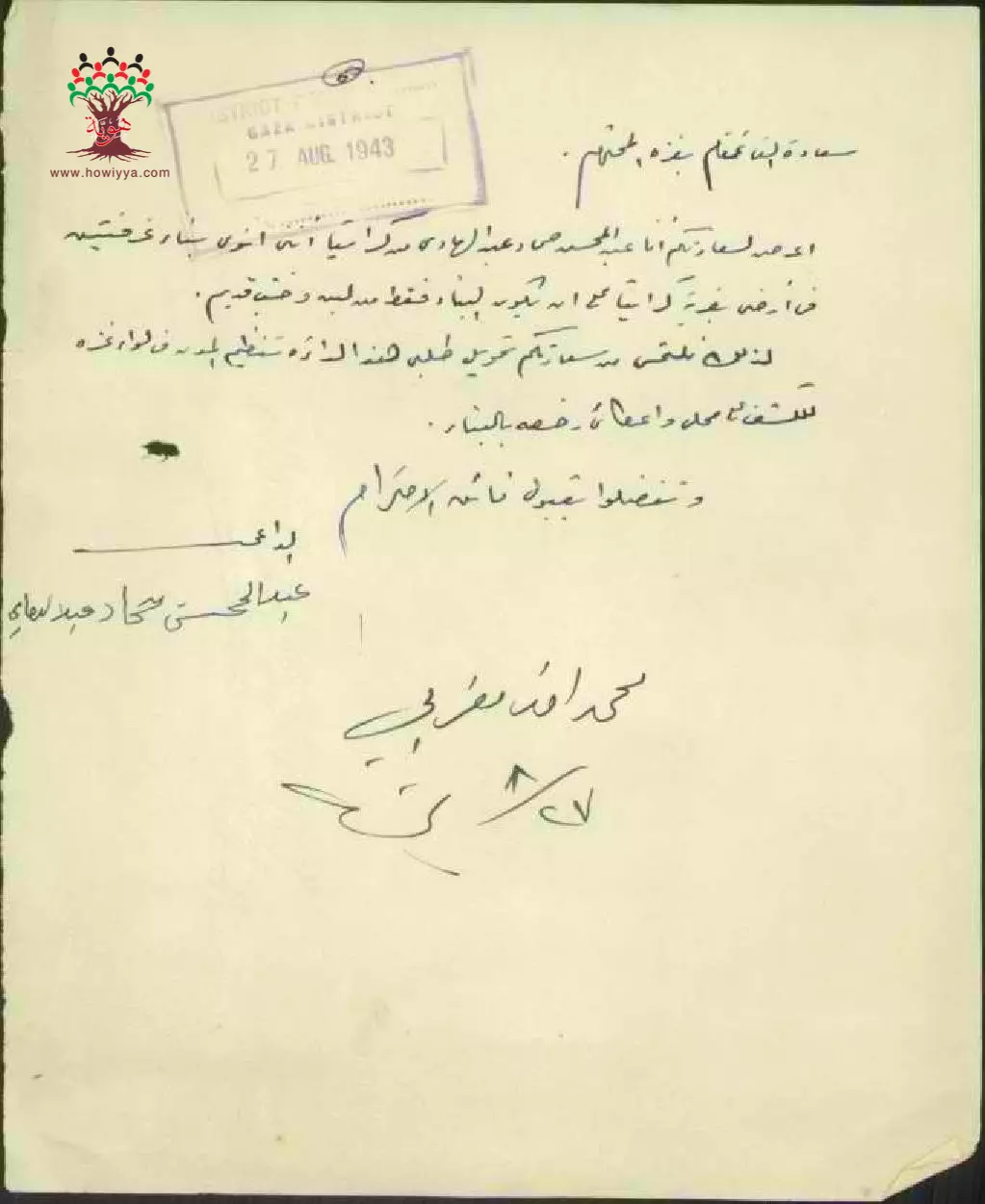
طلب رخصة بناء ل عبد المحسن حماد عبد الهادي-كرتيا -- 27/08/1943
-
طلب رخصة بناء ل حسن عبد الرازق-كرتيا --21/08/1943

-
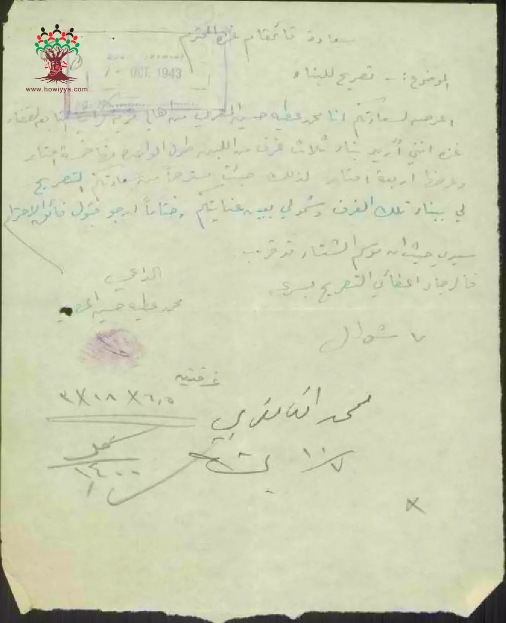
طلب رخصة بناء ل محمد عطية حسين المصري-كرتيا --07/10/1943
-
جدول رخص بناء في كرتيا بتاريخ 20-8-1943
-
رخصة بناء ل أحمد خليل فياض-كرتيا -- 13/12/1943
-
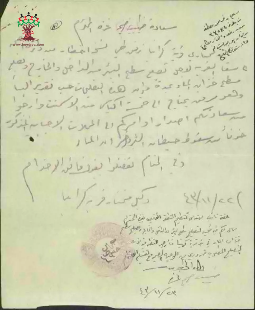
رسالة من وكيل مختار قرية كرتيا الى طبيب صحة غزة بخصوص ترميم سطح بئر القرية -- 22/11/1943
-
طلب رخصة بناء ل حسن عقيل عبد الرازق-كرتيا -- 21/08/1943
-
جدول رخص ابنية في قرية كرتيا -- 12/08/1943

-
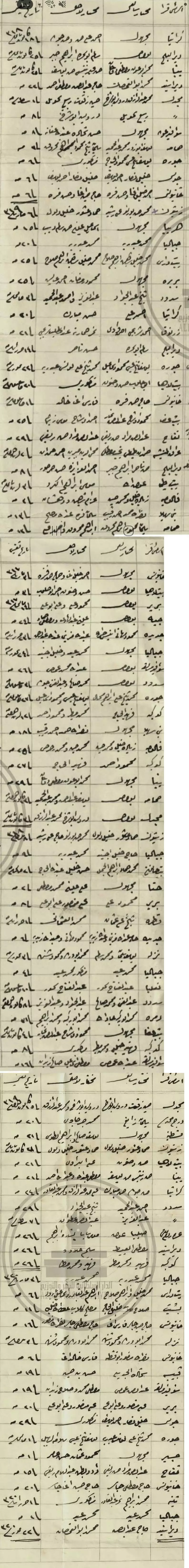
أسماء مخاتير كل من أحياء مدينة غزة وقرى قضائها أوائل القرن الماضي نهاية العهد العثماني فيما بين ١٩٠٠م - ١٩٠٥م --أنقر الصورة للتمعن باﻷسماء فهة كاملة طالت قريتكم كرتيا
Want to browse more? 80,000 pictures were grouped in these gallaries:
-
طلب رخصة بناء ل خليل صالح-كرتيا --16/08/1943
-
جدول رخص بناء في كرتيا بتاريخ 12-8-1943
-
طلب رخصة بناء ل عبد الله خليل جوك-كرتيا -- 17/07/1943
-
طلب رخصة بناء ل عبد الله سليم عبد الهادي-كرتيا -- 17/07/1943
-
طلب رخصة ترميم ل ابراهيم عيسى-كرتيا -- 07/10/1943
-
طلب رخصة بناء ل عبد المحسن حماد عبد الهادي-كرتيا -- 27/08/1943
-
طلب رخصة بناء ل حسن عبد الرازق-كرتيا --21/08/1943
-
طلب رخصة بناء ل محمد عطية حسين المصري-كرتيا --07/10/1943
-
جدول رخص بناء في كرتيا بتاريخ 20-8-1943
-
رخصة بناء ل أحمد خليل فياض-كرتيا -- 13/12/1943
-
طلب رخصة بناء ل حسن عقيل عبد الرازق-كرتيا -- 21/08/1943
-
جدول رخص ابنية في قرية كرتيا -- 12/08/1943
| Display Name | Clan/Hamolah | Country of Residence |
| هيام جوده | جوده | الامارات, الامارات |
| مؤنس فروانه | فروانه | - |
| khaled isamil almghari | المغاري | dair elbalah |
| فارس فلسطين | المغاري | كرتيا |
| الحميدي | الحميدي | غزة, فلسطين |
| Ahmed Abu Saada | أبو سعده | MO, USA |
| Abu Tareq | الخالدي | - |
| طلال | ارشيد | - |
| ابو عبدالله ابو لمظي | ابو لمظي | غزة, فلسطين |
| akram abahre | عباهره | - |
| Hasan Fayyad | Fayyad | - |
- برنامج شاهد على النكبة الحلقة الأولى - كرتيا Duration: 6 min 54 sec
- الذاكرة مفتاح العودة--الحلقة 38- قرية كرتيا Duration: 23 min 22 sec
 Fake Valor: Why Did Zionist Jews Hoist Nazis Flag on Their Ships in the 1930s?
What is new?
-
Facts About Oct. 7th Gaza Raid
-
Remined Us Please: Who Did Rape Whom? Was it Palestinians who raped Israelis? Or, was the other way around? You'll be the judge
-
When Prof. Edward Said was invited to debate Bibi Netanyahu in the 1980s, watch what happened!
-
Ezra Klein of the NY Times on the "Jewish Race".
-
Abusing Blood Libel!
-
How and why Israeli Jewry has become the most hated cult?
-
Did Israeli Soldiers Activate The Hannibal Direective On Oct. 7th? You Be The Judge
-
Zionist FAQ: Isn't it true that Palestinians don't want peace? Palestinians never accepted the two-state solution
- Facts about Haavara (Transfer) Agreement between Ben-Gurion & Hitler
-
Haavara FAQs: Why Did Zionist Jews Hoist Nazis' Flags on Their Ships in the 1930s?
- Haavara FAQs: When Chaim Weizmann met FDR in mid-1943, why was he silent about rescuing European Jewry?
-
Dear ChatGPT: How did Palestinians resist Napoleon's invasion of their country in 1799?
-
Dear ChatGPT: Gaza had a vibrant Jewish community in the mid-17th century. What happened to them?
-
Dear ChatGPT: Why did the Jewish Agency suppress news of the Holocaust during WWII?
-
Video Playlist: Jews share their DNA tests to end the conflict for good.
-
A Tale of Two Conflicts: Examining the Definition of Genocide
-
Prof. Abraham Polak And The Suppressed History of the Khazars and European Jewry
-
How Ronald Reagan would have framed the genocide in Gaza if he were still alive?
-
Haavara FAQs: Let us do the math: how many German Jews did The Haavara Agreement save?
-
Zionist FAQs: The Hebron Massacre of 1929, "clearly proves" that Palestinians are antisemitic, how could you deny it?
-
Zionist FAQs: Why Anti-Zionist Is Not Antisemitism?
-
Zionist FAQs: Isn't it true that the KGB created Palestinian Nationalism in the early 1960s?
- Zionist FAQs: Muslims are killing Muslims all the time; why are Israeli Jews being singled out in the media?
- Zionist FAQs: How is Israel an apartheid state when 20% of its citizens are Arabs who enjoy full rights?
-
Haavara FAQs: Why Did Dorothy Thompson Flip From A Zionist Advocate to A Silenced Dissenter?
-
Haavara FAQs: Analysis of Herzl's Uganda Scheme and how it could have saved millions of Jews.
-
Haavara FAQs: Why did Hayim Greenberg describe American Jewry as "morally bankrupt" in early 1943?
-
Haavara FAQs: What if the Evian Conference was a resounding success? What would have been the impact of saving European Jewry on Zionism?
- Haavara FAQs: What if the six million were saved, how that would have impacted the Zionist project?
-
Haavara FAQs: How did Zionist leaders react when Europe's Jews lingered in the DP camps after WWII ended?
-
Why does the American Jewish community repeat lies that David Ben-Gurion had debunked before he died?
-
Who has the power to rename the Tatar/Khazar Gene Marker to Jewish IV?
-
Zionist FAQs: Why won't Egypt, Syria, and Jordan take their people back? Jews are indigenous to Palestine, and Arabs immigrated after Jews developed the country. Arabs should leave.
-
Haavara FAQs: Did Hitler and the Nazis conflate between Judaism and Zionist? If that wasn't case, then why?
-
Haavara FAQs: Winston Churchill and antisemitism, a collection of articles written Churchill.
-
Haavara FAQs: Broken by country, how many Jews survived vs. killed during the Holocaust?
-
Haavara FAQs: Why did European Jews vote with their feet and to immigrated to the Americas, not Palestine, after WWII?
-
Watch this American Jewish Girl describing Israeli Jews' cognitive dissonance like no other in under two minutes
-
Haavara FAQs: When the Nazis went out of their way to hide the Holocaust, Israeli Jews did the exact opposite by broadcasting their genocide of Gazans. But why?
-
Haavara FAQs: How Zionist Jews went out of their to show their appreciation to Nazism and Fascism?
- Haavara FAQs: Why Zionist leaders were against bombing the death camps & the Railroads leading to them?
-
Haavara FAQs: Hitler's message to the British and American people: If Jews are such noble citizens and you care about them, how come you're not letting them in? I will gladly ship them to you at my expense, even on luxury liners!
-
A shortlist of Zionist and Israeli false flag operations in the name Jews.
-
The Most Moral Army
- The Land of Kapos (Israel): Where the brave are boycotted and Kapos walk free.
- Why did early Zionists often named their communal enterprises "colonial"?
- Zionist Relations with Nazi Germany by Faris Glubb
-
Two NY Times advertisements by Zionists in the early 1943 that exposes Zionists' treason at the height of the calamity
- Facts Not Lies about the Palestinian-Israeli Conflict.
- Site's pictures have been categorized
- Campgain Against Lice
- A Survey of Palestine, the official source about Palestine before Nakba produced by the British Mandate; over 1200 pages.
- Satellite View & Google Earth: Over 6,000 placemarks identifying all destroyed towns, W. Bank & Gaza Strip Towns, & refugee camps.
- PalestineRemembered.com and its Nakba Oral History Project were featured on al-Jazeera Satellite TV.
- Nakba Oral History Video Podcast:
 Over 700 Oral History interviews (including 3,500+ hours of recording) can be viewed online.
 - Palestine Village Statistics Project
- Gaza Jail Break
- النسخة العربية للموقع الان متوفرة
- Videos: Documenting the destroyed villages in video: Tracing all that remains since Nakba.
- Videos: Responding to Zionist Propaganda
- Interview: The ethnic cleansing of Palestine: George Galloway interviews Israeli Historian Ilan Pappe.
- For Palestinians, memory matters. It provides a blueprint for their future By George Bisharat.
- Zionist FAQ now available in Hebrew שאלות שציונים שואלים, עכשיו בעברית
- Video: The Stephen Walt and John Mearsheimer report on the influence of the Israel Lobby on U.S. Foreign Policy
- The Palestinian-Israeli conflict for beginners
