| PalestineRemembered | About Us | Oral History | العربية | |
| Pictures | Zionist FAQs | Haavara | Maps | |
| Search |
| Camps |
| Districts |
| Acre |
| Baysan |
| Beersheba |
| Bethlehem |
| Gaza |
| Haifa |
| Hebron |
| Jaffa |
| Jericho |
| Jerusalem |
| Jinin |
| Nablus |
| Nazareth |
| Ramallah |
| al-Ramla |
| Safad |
| Tiberias |
| Tulkarm |
| Donate |
| Contact |
| Profile |
| Videos |
Welcome To Kawfakha - كوفخة (כופח'ה)
|
District of Gaza
Ethnically cleansed days ago |
العربية Google Earth |
 |
Gallery (20) |
- Statistics & Facts
-
Before & After

- Satellite View
- Articles 4
- Pictures 20
- Land Deeds 5
- Members 6
- Families
- All That Remains
- Wikipedia
- Videos
- Guest Book 16
- Links 1
| Statistic & Fact | Value | ||||||||||||
| Occupation Date | May 25, 1948 | ||||||||||||
| Distance From District | 19 (km) East of Gaza | ||||||||||||
| Elevation | 150 (meters) | ||||||||||||
| Before & After Nakba, Click Map For Details |
|||||||||||||
|
|||||||||||||
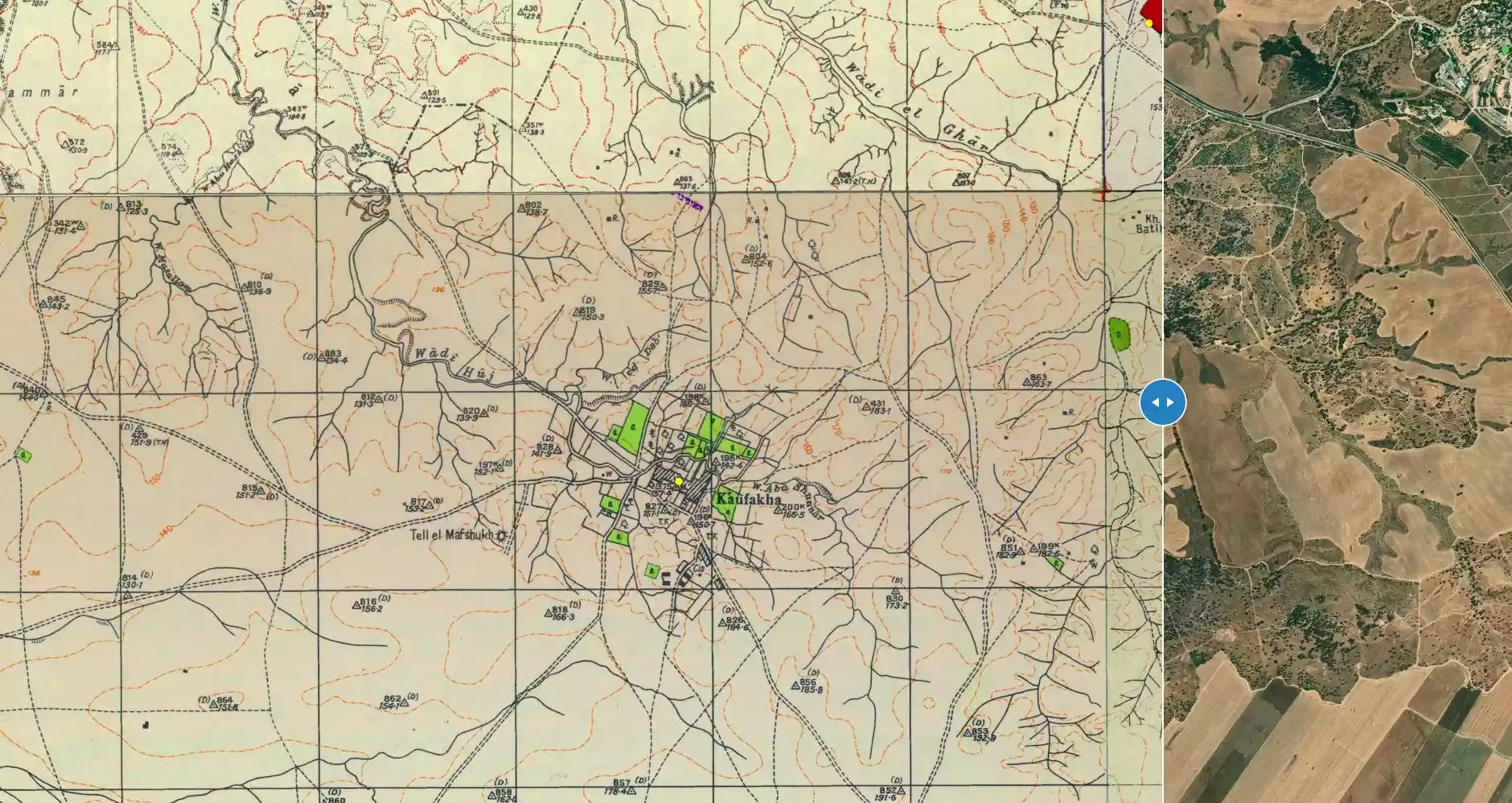
| Map Location | See location #44 on the map View from satellite |
||||||||||||
| Military Operation | Possibly Operation Barak | ||||||||||||
| Attacking Units | Negev Brigade | ||||||||||||
| Defenders | Egyptian Army | ||||||||||||
| Exodus Cause | Military assault by Zionist troops | ||||||||||||
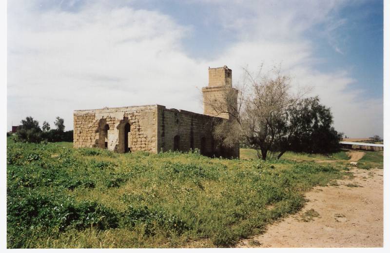
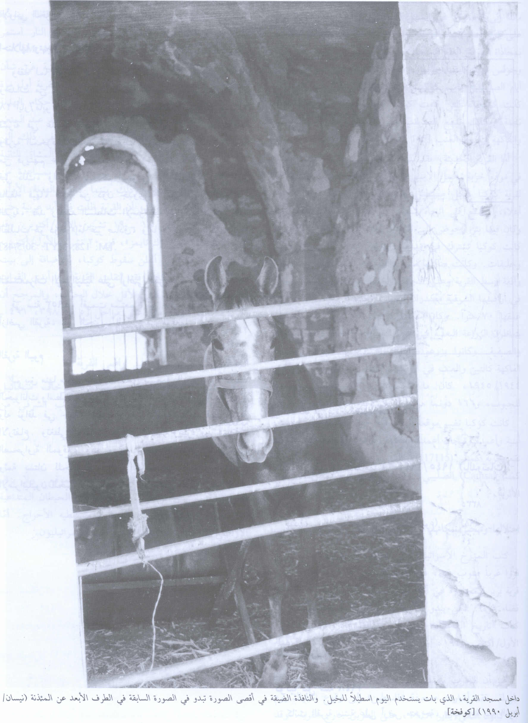
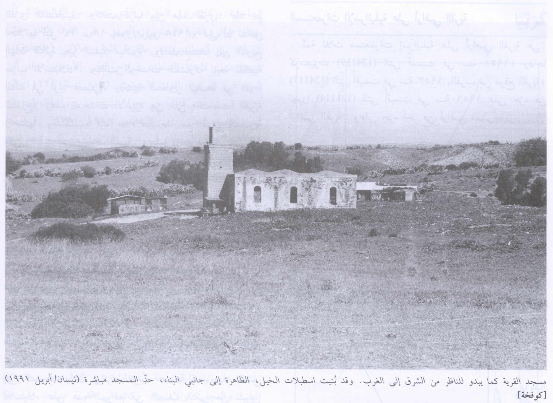
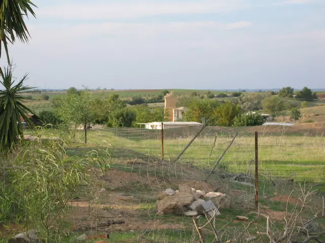
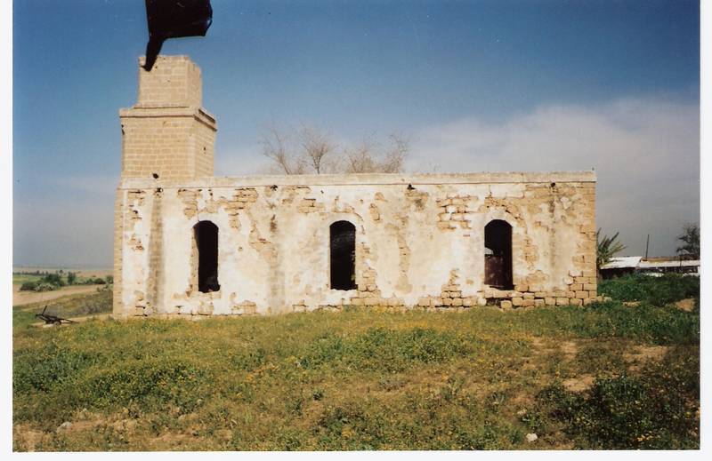
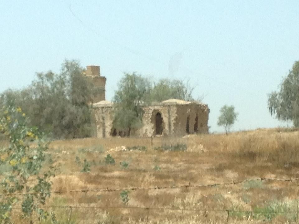
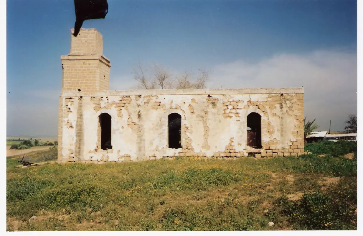
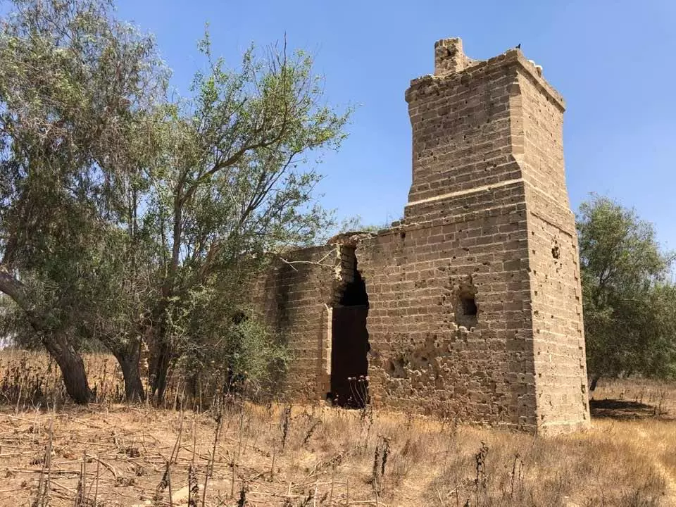
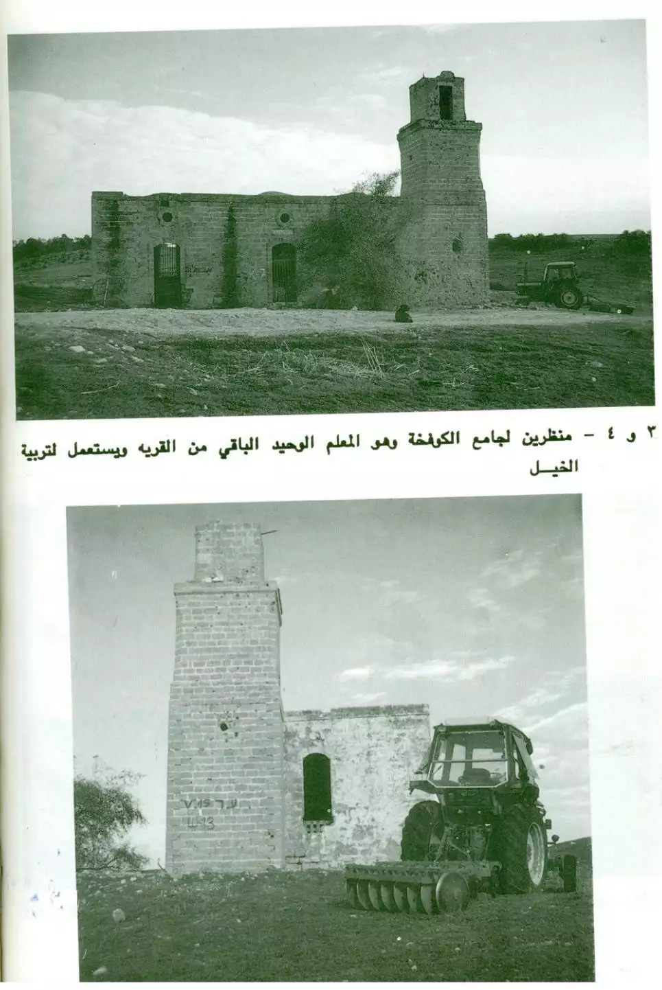
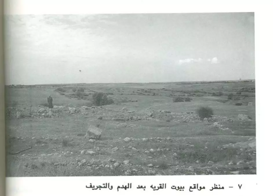
| Village Temains | The village has been completely obliterated with the exception of the village mosque (now functions as a horse stable) | ||||||||||||
| Ethnically Cleansing | Kawfakha inhabitants were completely ethnically cleansed. | ||||||||||||
| Pre-Nakba Land Ownership |
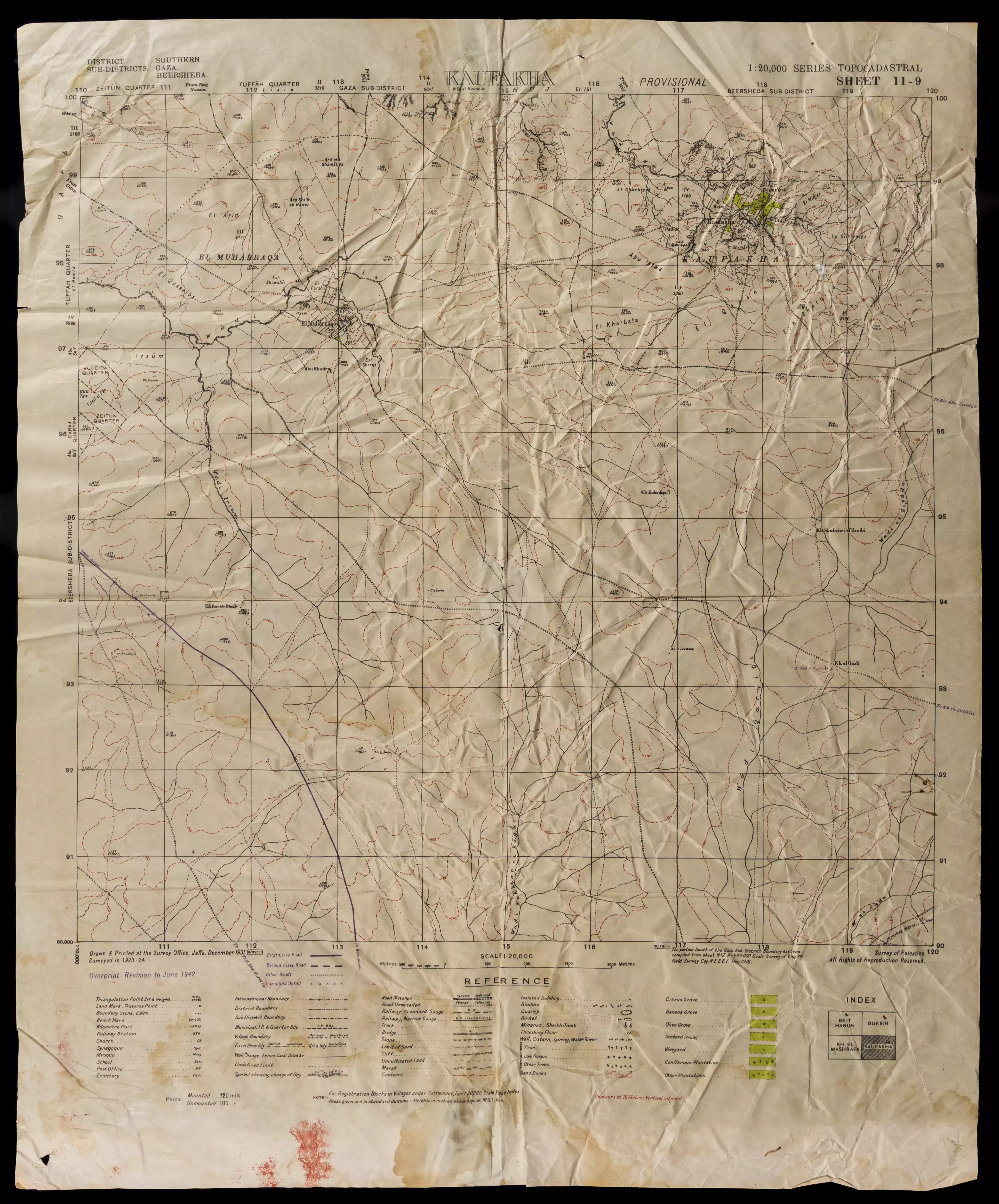
**Town Lands' Demarcation Maps |
||||||||||||
| Land Usage As of 1945 |
|
||||||||||||
| Population |
|
||||||||||||
| Number of Houses |
|
||||||||||||
| Near By Towns |
|||||||||||||
|
|||||||||||||
| Schools | Kawfakha had an elementary school for boys. | ||||||||||||
| Inhabitants Place of Origin | In the 19th century, Kawfakha was founded by people from Gaza city. | ||||||||||||
| Places of Warship | The village had a well known mosque, which functions now as a horse stable by a Jewish settler. | ||||||||||||
| Nearby Wadies & Rivers | The village was situated on the southern bank of Wadi Abu Shunnar.. | ||||||||||||
| Archeological Sites | The village contained the remains of cisterns, marble columns, a Corinthian capital, mosaic walkways, and pottery | ||||||||||||
| Exculsive Jewish Colonies Who Usurped Village Lands |
Nir 'Aqiva | ||||||||||||
| Featured Video | |||||||||||||
Village Before NakbaThe village stood on a stretch of sandy, rolling land in the northern Negev. A network of secondary roads linked it to the highways between Gaza and Julis, which ran parallel to the coastal highway. Kawfakha was founded in the late nineteenth century by Gaza city residents who came to cultivate the surrounding land. At its center was a mosque that was well-known in the region, built during the reign of the Ottoman sultan Abd al-Hamid II (1876–1909). Houses were spread along a northwest–southeast axis in a rectangular pattern, adjacent to the southern bank of Wadi Abu Shunnar, a tributary of Wadi Hawdaj. Kawfakha had an elementary school and some small shops. Its inhabitants, who were Muslim, obtained water for domestic use from two wells inside the village. For agriculture, they relied on both rainfall and irrigation (from wells, cisterns, and reservoirs that collected rainwater in winter). They planted the land on the northern side of the village with fruit trees, such as apricots, olives, almonds, grapes, and figs, and grew grain on the other sides. In 1944/45 a total of 87 dunums was irrigated or used for orchards, and 7,768 dunums (of public land) were allotted to cereals. The village contained the ruins of Khirbat al-Kawfakha which included remnants of cisterns, marble columns, a Corinthian capital, mosaic walkways, and pottery.Village Occupation and Ethnic CleaningThe village was raided by units of the Negev Brigade on the night of 27–28 May 1948, according to Israeli historian Benny Morris. The New York Times reported on 30 May that it had been captured along with the adjacent village of al-Muharraqa. The inhabitants were driven out of the village, although they had 'earlier repeatedly asked to surrender, accept Jewish rule and be allowed to stay, all to no avail.' Their request to remain in the village was denied by the Israeli authorities on the grounds that such requests were always 'either insincere or unreliable.'Zionists Colonies on Village LandsThe settlement of Nir 'Aqiva was established in 1953 on village lands, southwest of the village site.Village TodayOnly the mosque remains, and it is used as a storehouse for animal fodder and as a horse stable. It is a stone structure with arched entrances and windows on all sides; its roof is topped by three shallow domes. The site, which contains piles of rubble and is overgrown with cactuses and other desert plants, has been fenced in and serves as a pasture. There is a citrus grove west of it, and grain is grown by Israeli farmers on part of the surrounding land.SourceDr. Walid al-Khalidi, 1992: All That Remains. |
|||||||||||||
| Related Maps | Town Lands' Demarcation Maps خرائط للقضاء توضح حدود القرى والاودية Town's map on MapQuest View from satellite Help us map this town at WikiMapia |
||||||||||||
| Related Links | Wikipedia's Page Google Search Google For Images Google For Videos |
||||||||||||
| More Information | في كتاب كي لا ننسى في كتاب بلادنا فلسطين المزيد من موقع هوية |
||||||||||||
- Village Mosque Now Used As a Stable for Horses In 1990
Scanned from "All That Remains" by Dr. Walid Khalidi - Village Mosque In 1991
Scanned from "All That Remains" by Dr. Walid Khalidi 1 - Remaining Mosque- now fenced into ranch. Fall 2006. Photo: Annemarie Jacir
Posted by Annemarie Jacir 5 - صوره لمسجد قريتي حصل عليها بعد بحث طوييل
Posted by عيسى شاكر الظاظا - صوره لمسجد قريتي حصل عليها بعد بحث طوييل
Posted by عيسى شاكر الظاظا - صوره حديثه سنه 2013 لمسجد قريه الكوفخه المهجره...
Posted by محمد ابو عويلى 1 - صوره لمسجد كوفخة
- That is how the "civilized" erased and replaced us: Kawfakha was completely obliterated except for the village mosque, as you see -- كوفخة باتت أثر بعد عين بإستثناء الجامع. من هنا مر الهمجّ
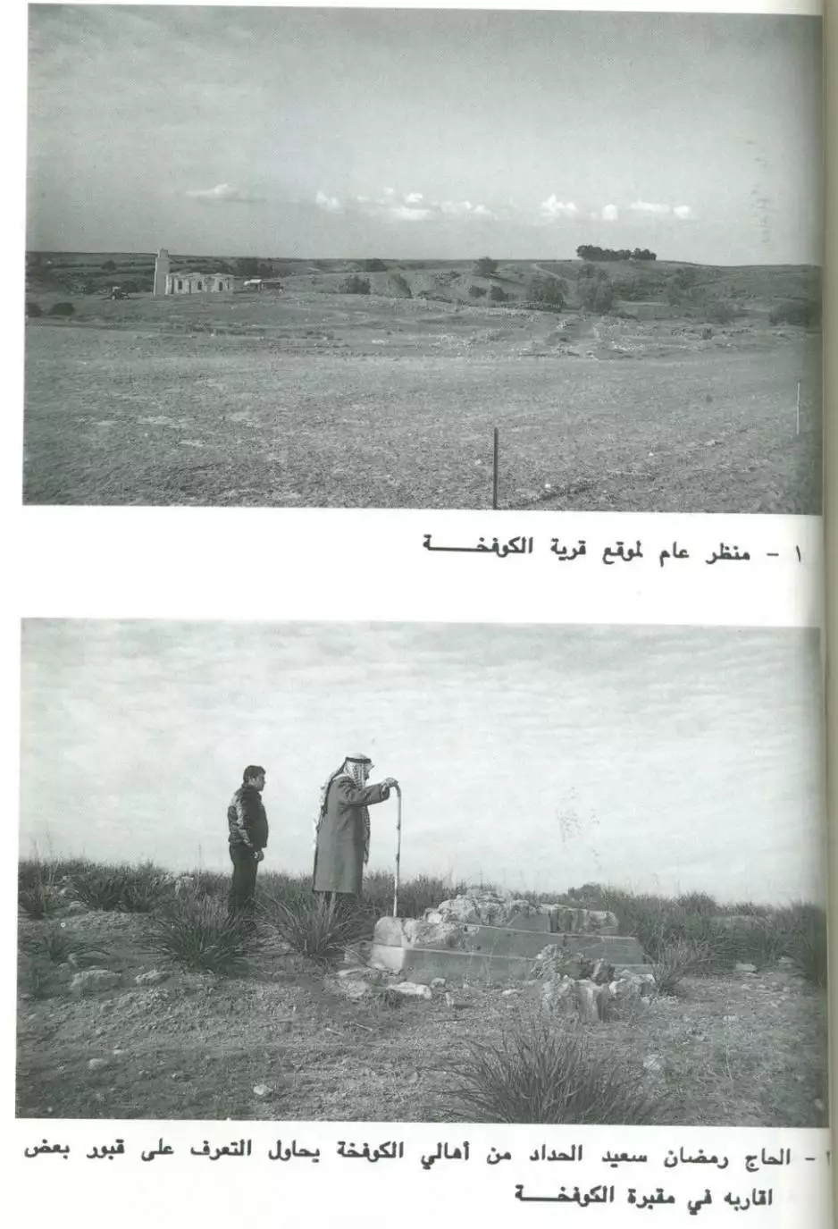
- الحاج رمضان سعيد الحداد من أهالي كوفخة يحاول التعرف على قبور بعض اقاربه في مقبرة كوفخة
- Kawfakha's mosque in the 1980s
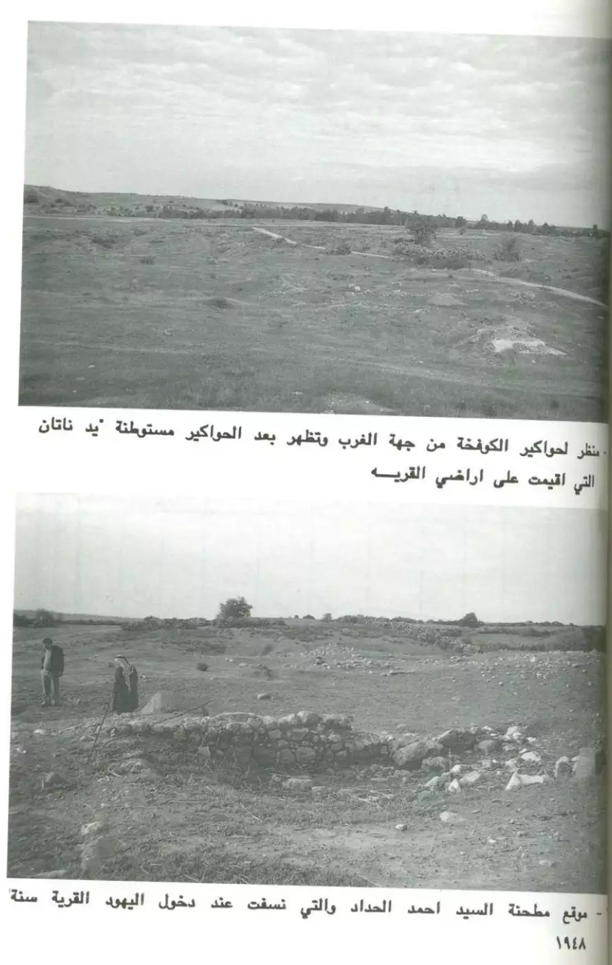
- موقع مطحنة السيد أحمد الحداد التي نسفت عند دخول القرية غضون حرب النكبة
- That is how the "civilized" erased and replaced us: Kawfakha was completely obliterated except for a few its main mosque, as you see
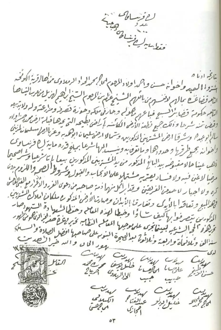
- وثائق تثبت ملكية الارض تعود لقبل النكبة
- وثائق تثبت ملكية الارض تعود لقبل النكبة #2
- وثائق تثبت ملكية الارض تعود لقبل النكبة #3
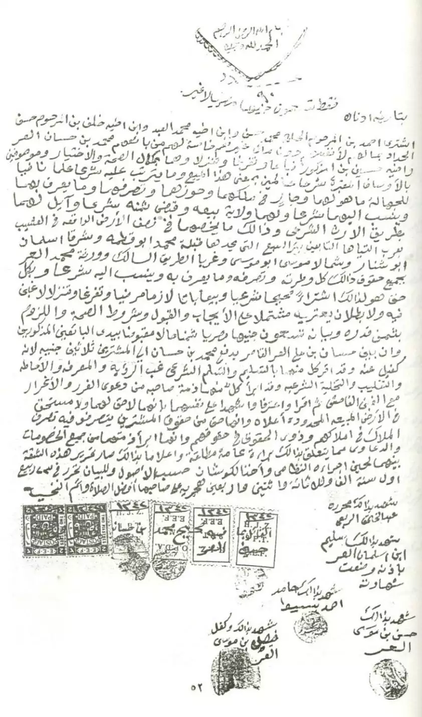
- وثائق تثبت ملكية الارض تعود لقبل النكبة #4
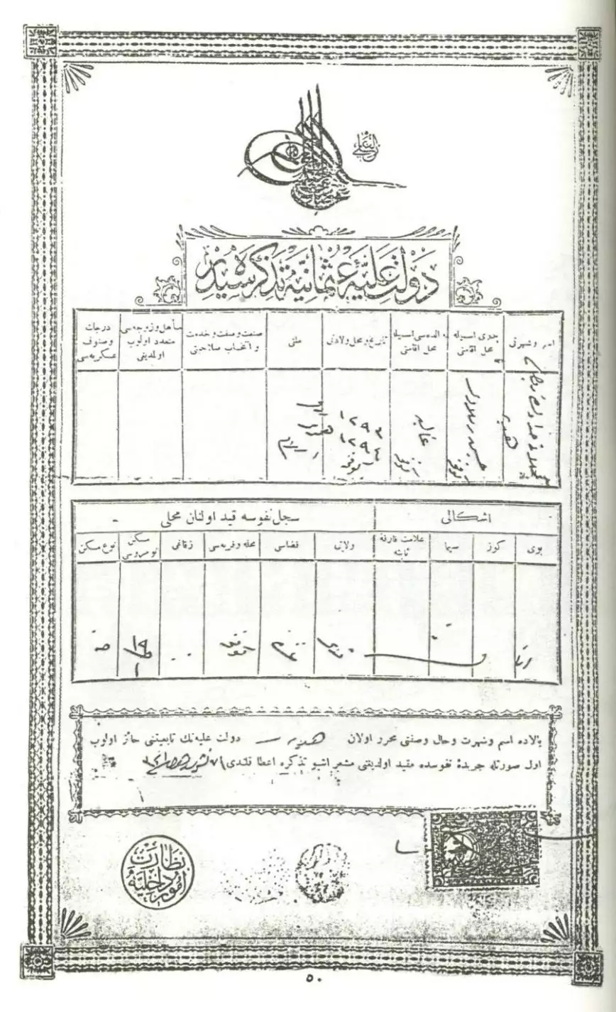
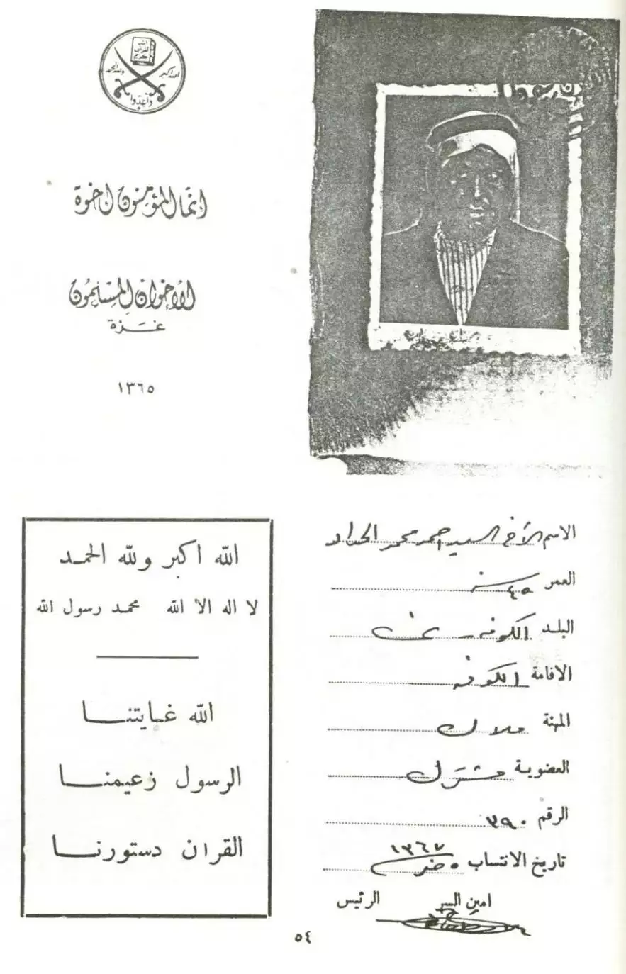
- بطاقة إنتساب السيد أحمد محمد الحداد -- 1367 هجرة -- 1948م
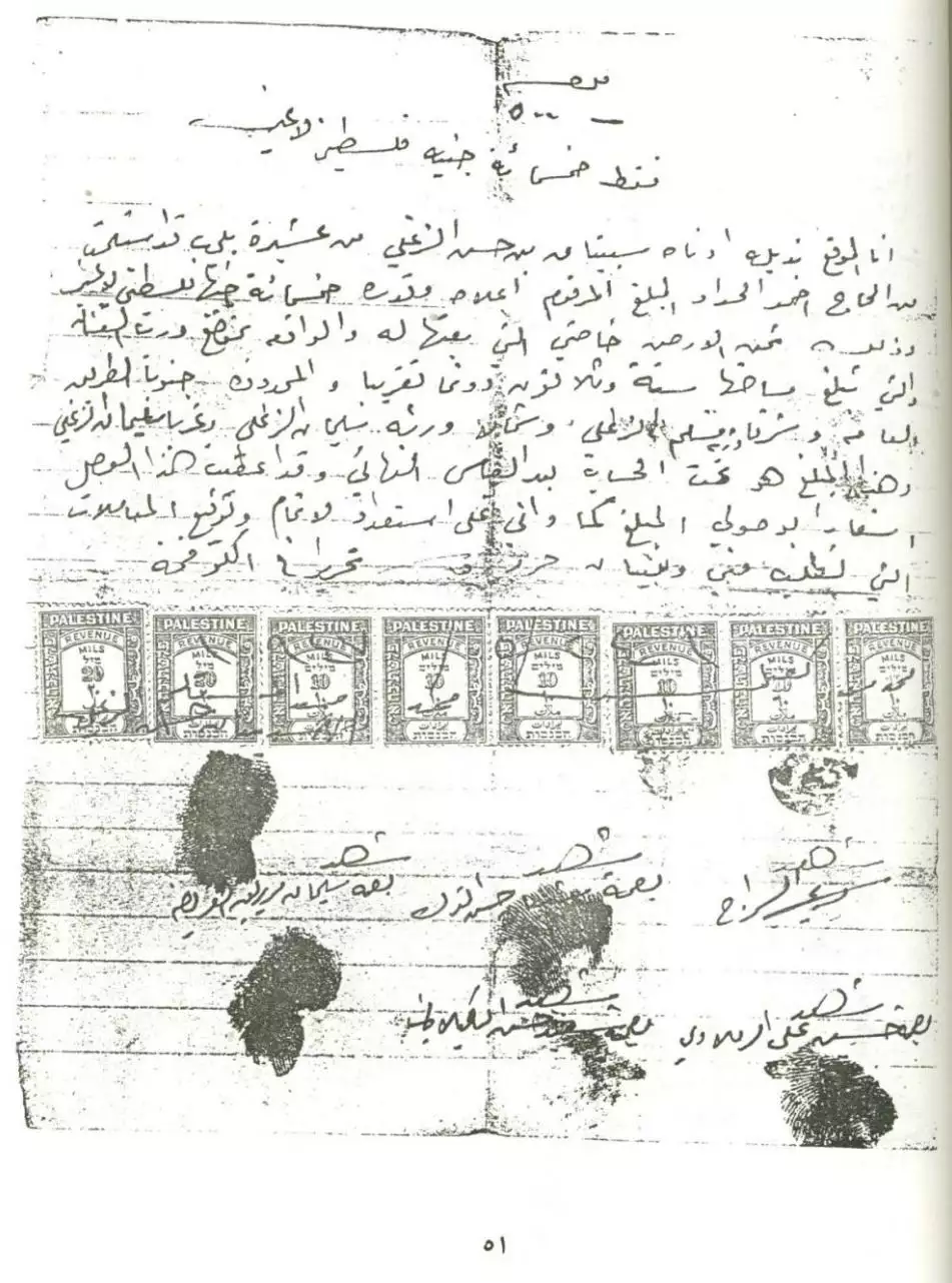
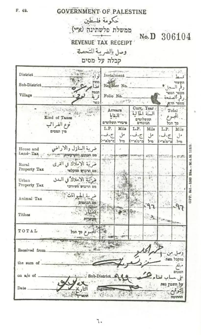
- وصل بالضريبة المتحصلة عن الحيوانات لأحمد الحلو-- 1939
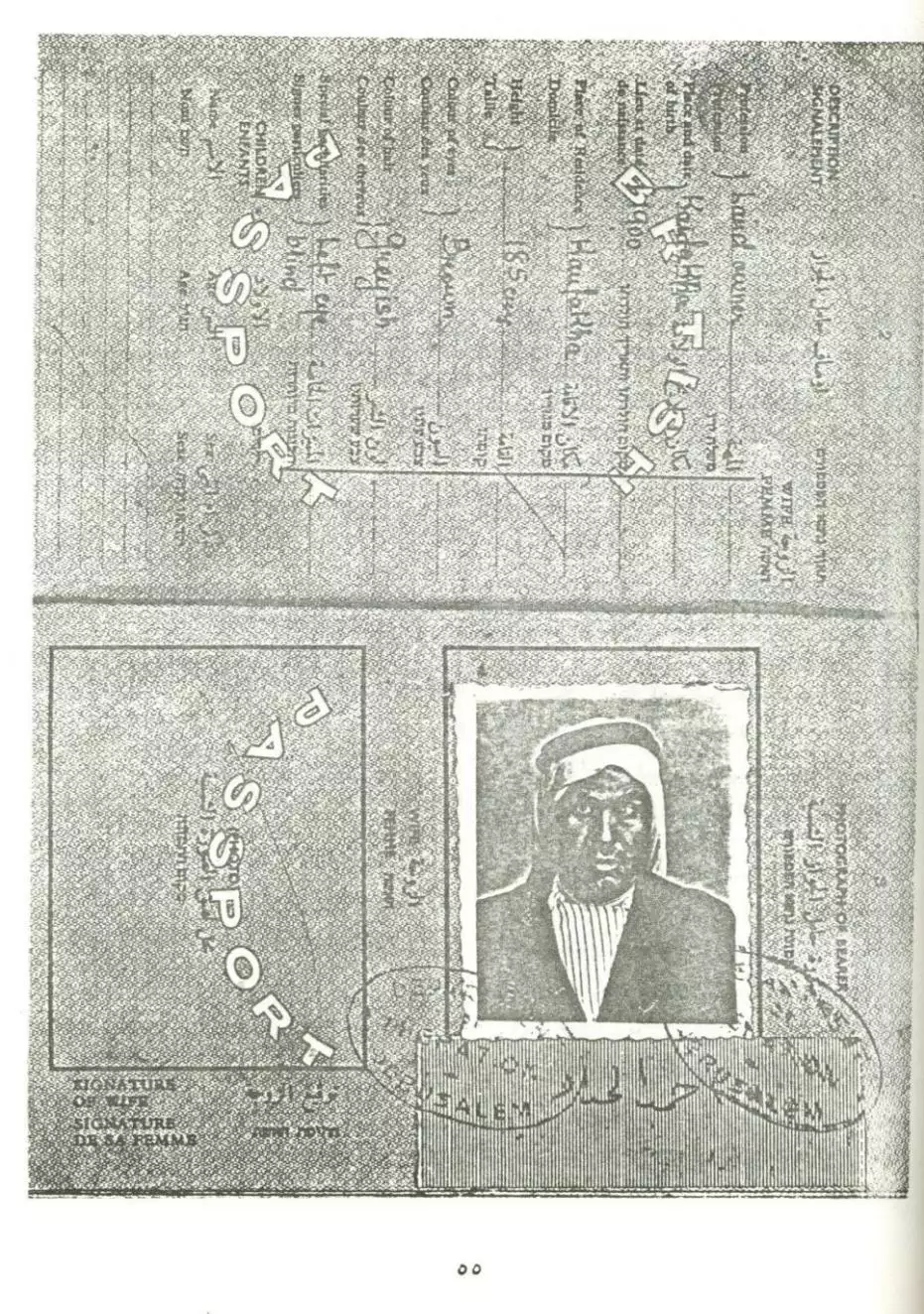
- وجواز سفر أحمد الحداد
- A map showing borders, roads, sacred places, topographical nature of hills, plains, slopes, natural landscape, and planting types. The map was published during the British Mandate, and was modified by the Maps and Images Service of the Israeli Military Forces in the 1940s.
Want to browse more? 80,000 pictures were grouped in these gallaries:
| Display Name | Clan/Hamolah | Country of Residence |
| H.Joha | Joha | Bonn, Germany |
| محمد ابو عويلى | Al traben | Gaza city, Palestine |
| leena | - | gaza |
| al_jaser | al ramlawi | gaza, algeria |
| Alali | alali | jordan, 0962 |
| naji zaza | - | - |
 Fake Valor: Why Did Zionist Jews Hoist Nazis Flag on Their Ships in the 1930s?
What is new?
-
Facts About Oct. 7th Gaza Raid
-
Remined Us Please:: Who Did Rape Who? Palestinians Raped Israelis? Or, was the other way around?
-
When Prof. Edward Said was invited to debate Bibi Netanyahu in the 1980s, watch what happened!
-
Ezra Klein of the NY Times on the "Jewish Race".
-
Abusing Blood Libel!
-
Did Israeli Soldiers Activate The Hanniba Direective On Oct. 7th? You Be The Judge
-
Zionist FAQ: Isn't it true that Palestinians don't want peace? Palestinians never accepted the two-state solution
- Facts about Haavara (Transfer) Agreement between Ben-Gurion & Hitler
-
Haavara FAQs: Why Did Zionist Jews Hoist Nazis' Flags on Their Ships in the 1930s?
- Haavara FAQs: When Chaim Weizmann met FDR in mid-1943, why was he silent about rescuing European Jewry?
-
Dear ChatGPT: How did Palestinians resist Napoleon's invasion of their country in 1799?
-
Dear ChatGPT: Gaza had a vibrant Jewish community in the mid-17th century. What happened to them?
-
Dear ChatGPT: Why did the Jewish Agency suppress news of the Holocaust during WWII?
-
Video Playlist: Jews share their DNA tests to end the conflict for good.
-
A Tale of Two Conflicts: Examining the Definition of Genocide
-
Prof. Abraham Polak And The Suppressed History of the Khazars and European Jewry
-
How Ronald Reagan would have framed the genocide in Gaza if he were still alive?
-
Haavara FAQs: Let us do the math: how many German Jews did The Haavara Agreement save?
-
Zionist FAQs: The Hebron Massacre of 1929, "clearly proves" that Palestinians are antisemitic, how could you deny it?
-
Zionist FAQs: Why Anti-Zionist Is Not Antisemitism?
-
Zionist FAQs: Isn't it true that the KGB created Palestinian Nationalism in the early 1960s?
- Zionist FAQs: Muslims are killing Muslims all the time; why are Israeli Jews being singled out in the media?
- Zionist FAQs: How is Israel an apartheid state when 20% of its citizens are Arabs who enjoy full rights?
-
Haavara FAQs: Why Did Dorothy Thompson Flip From A Zionist Advocate to A Silenced Dissenter?
-
Haavara FAQs: Analysis of Herzl's Uganda Scheme and how it could have saved millions of Jews.
-
Haavara FAQs: Why did Hayim Greenberg describe American Jewry as "morally bankrupt" in early 1943?
-
Haavara FAQs: What if the Evian Conference was a resounding success? What would have been the impact of saving European Jewry on Zionism?
- Haavara FAQs: What if the six million were saved, how that would have impacted the Zionist project?
-
Haavara FAQs: How did Zionist leaders react when Europe's Jews lingered in the DP camps after WWII ended?
-
Why does the American Jewish community repeat lies that David Ben-Gurion had debunked before he died?
-
Who has the power to rename the Tatar/Khazar Gene Marker to Jewish IV?
-
Zionist FAQs: Why won't Egypt, Syria, and Jordan take their people back? Jews are indigenous to Palestine, and Arabs immigrated after Jews developed the country. Arabs should leave.
-
Haavara FAQs: Did Hitler and the Nazis conflate between Judaism and Zionist? If that wasn't case, then why?
-
Haavara FAQs: Winston Churchill and antisemitism, a collection of articles written Churchill.
-
Haavara FAQs: Broken by country, how many Jews survived vs. killed during the Holocaust?
-
Haavara FAQs: Why did European Jews vote with their feet and to immigrated to the Americas, not Palestine, after WWII?
-
Watch this American Jewish Girl describing Israeli Jews' cognitive dissonance like no other in under two minutes
-
Haavara FAQs: When the Nazis went out of their way to hide the Holocaust, Israeli Jews did the exact opposite by broadcasting their genocide of Gazans. But why?
-
Haavara FAQs: How Zionist Jews went out of their to show their appreciation to Nazism and Fascism?
- Haavara FAQs: Why Zionist leaders were against bombing the death camps & the Railroads leading to them?
-
Haavara FAQs: Hitler's message to the British and American people: If Jews are such noble citizens and you care about them, how come you're not letting them in? I will gladly ship them to you at my expense, even on luxury liners!
-
A shortlist of Zionist and Israeli false flag operations in the name Jews.
-
The Most Moral Army
- The Land of Kapos (Israel): Where the brave are boycotted and Kapos walk free.
- Why did early Zionists often named their communal enterprises "colonial"?
- Zionist Relations with Nazi Germany by Faris Glubb
-
Two NY Times advertisements by Zionists in the early 1943 that exposes Zionists' treason at the height of the calamity
- Facts Not Lies about the Palestinian-Israeli Conflict.
- Site's pictures have been categorized
- Campgain Against Lice
- A Survey of Palestine, the official source about Palestine before Nakba produced by the British Mandate; over 1200 pages.
- Satellite View & Google Earth: Over 6,000 placemarks identifying all destroyed towns, W. Bank & Gaza Strip Towns, & refugee camps.
- PalestineRemembered.com and its Nakba Oral History Project were featured on al-Jazeera Satellite TV.
- Nakba Oral History Video Podcast:
 Over 700 Oral History interviews (including 3,500+ hours of recording) can be viewed online.
 - Palestine Village Statistics Project
- Gaza Jail Break
- النسخة العربية للموقع الان متوفرة
- Videos: Documenting the destroyed villages in video: Tracing all that remains since Nakba.
- Videos: Responding to Zionist Propaganda
- Interview: The ethnic cleansing of Palestine: George Galloway interviews Israeli Historian Ilan Pappe.
- For Palestinians, memory matters. It provides a blueprint for their future By George Bisharat.
- Zionist FAQ now available in Hebrew שאלות שציונים שואלים, עכשיו בעברית
- Video: The Stephen Walt and John Mearsheimer report on the influence of the Israel Lobby on U.S. Foreign Policy
- The Palestinian-Israeli conflict for beginners
