| PalestineRemembered | About Us | Oral History | العربية | |
| Pictures | Zionist FAQs | Haavara | Maps | |
| Search |
| Camps |
| Districts |
| Acre |
| Baysan |
| Beersheba |
| Bethlehem |
| Gaza |
| Haifa |
| Hebron |
| Jaffa |
| Jericho |
| Jerusalem |
| Jinin |
| Nablus |
| Nazareth |
| Ramallah |
| al-Ramla |
| Safad |
| Tiberias |
| Tulkarm |
| Donate |
| Contact |
| Profile |
| Videos |
Welcome To 'Iraq Suwaydan - عراق سويدان (עיראק סוידאן)
|
District of Gaza
Ethnically cleansed days ago |
العربية Google Earth |
 |
Gallery (37) |
- Statistics & Facts
-
Before & After

- Satellite View
- Articles 11
- Pictures 37
- Aerial Views 1
- Oral History 1
- Members 42
- Families
- All That Remains
- Wikipedia
- Videos 2
- Guest Book 23
- Links 4
| Statistic & Fact | Value | ||||||||||||
| Occupation Date | November 9, 1948 | ||||||||||||
| Distance From District | 27 (km) North East of Gaza | ||||||||||||
| Elevation | 100 (meters) | ||||||||||||
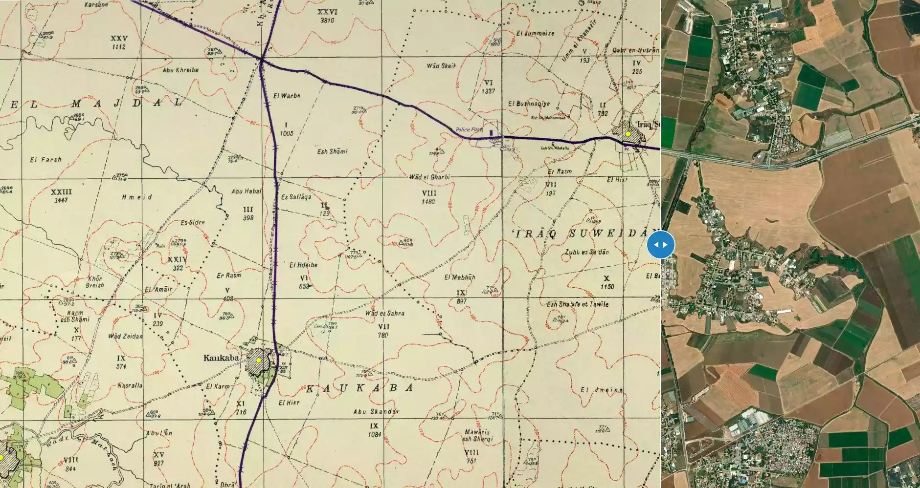
| Before & After Nakba, Click Map For Details |
|||||||||||||
|
|||||||||||||
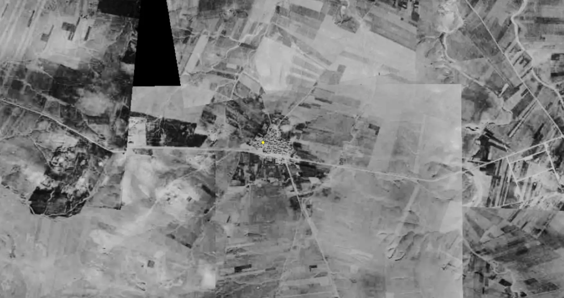
| Pre-Nakba Aerial View |
|||||||||||||
|
|||||||||||||
| Map Location | See location #25 on the map View from satellite |
||||||||||||
| Military Operation | Operation Yo'av | ||||||||||||
| Attacking Units | Ninth Battalion of the Armored Brigade | ||||||||||||
| Defenders | Egyptian Army | ||||||||||||
| Exodus Cause | Military assault by Zionist troops | ||||||||||||
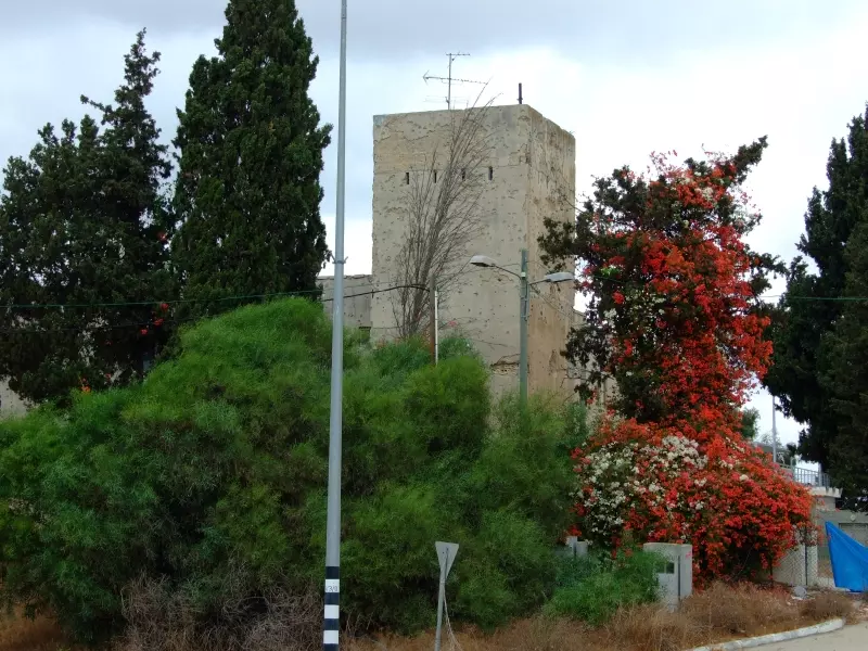
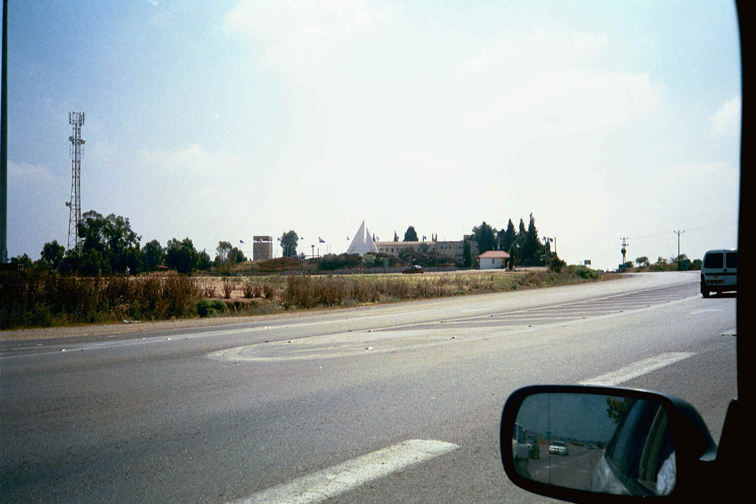
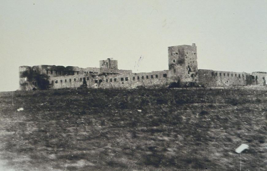
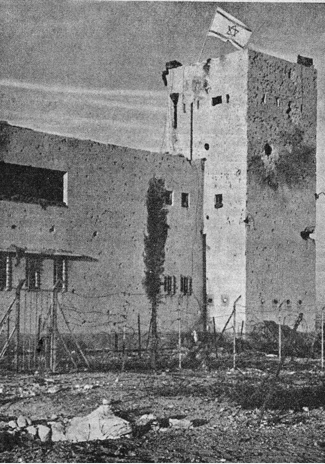
| Village Temains | The village was mostly destroyed with the exception of the British Police Station. | ||||||||||||
| Ethnically Cleansing | 'Iraq Suwaydan inhabitants were completely ethnically cleansed. | ||||||||||||
| Pre-Nakba Land Ownership |
**Town Lands' Demarcation Maps |
||||||||||||
| Land Usage As of 1945 |
|
||||||||||||
| Population |
|
||||||||||||
| Number of Houses |
|
||||||||||||
| Near By Towns |
|||||||||||||
|
|||||||||||||
| Schools | In 1947, 'Iraq Suwaydan shared an elementary school for boys with the nearby villages of 'lbdis and Bayt 'Affa, and when it opened its doors it had an an initial enrollment of 104 students. | ||||||||||||
| Archeological Sites | The village contained Khirbat al-Shaykh Muhammad and Khirbat al-Shaykh 'Abdallah, which both had artifacts from the Byzantine period. | ||||||||||||
| Exculsive Jewish Colonies Who Usurped Village Lands |
Yad Natan, 'Otzem, Sde Yo'av, and Beyt Yo'av. | ||||||||||||
| Featured Video | |||||||||||||
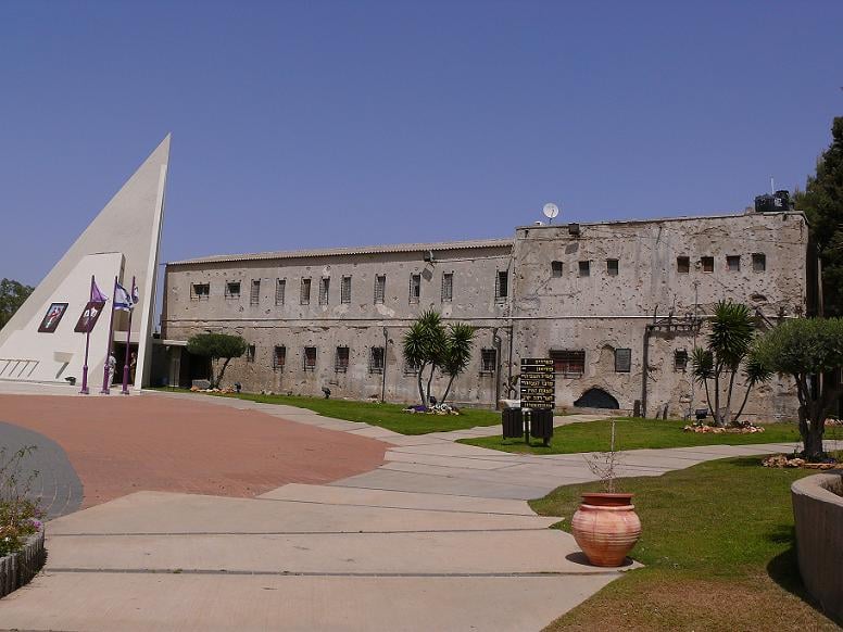
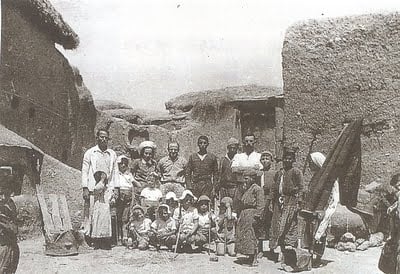
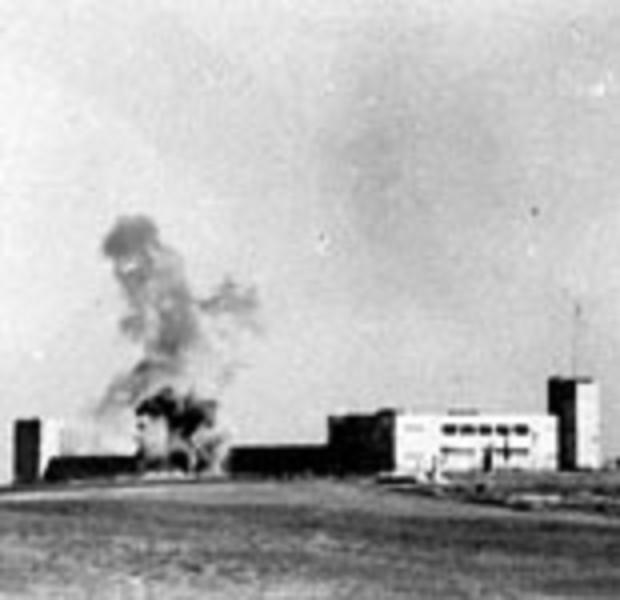
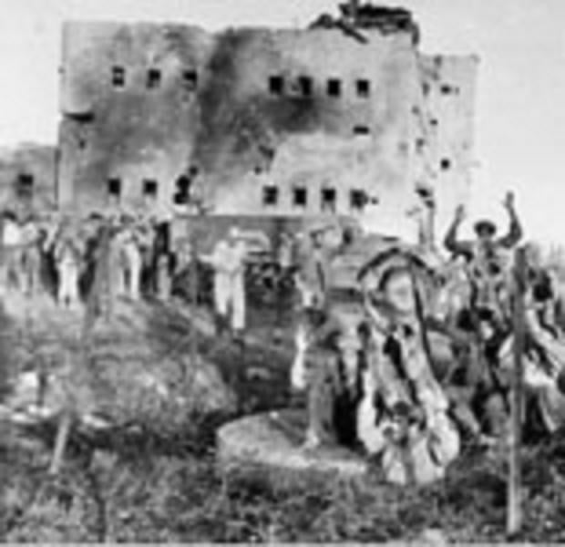
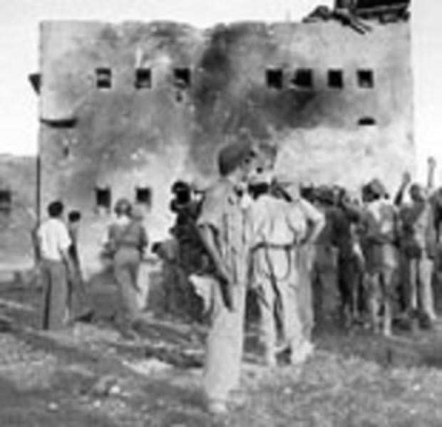
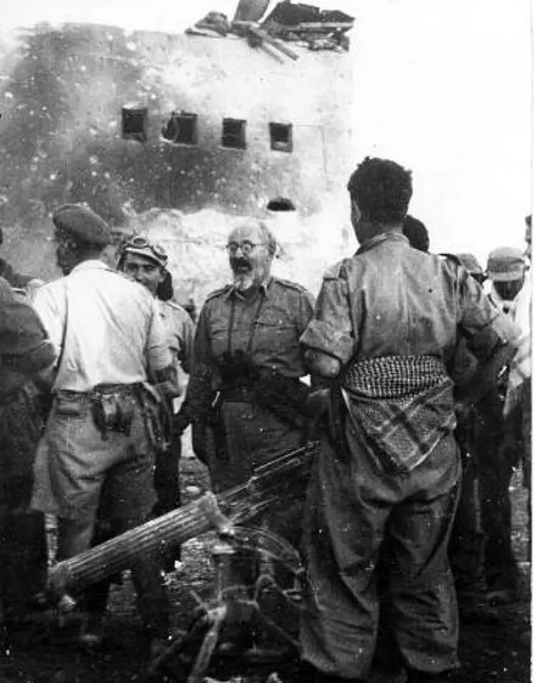
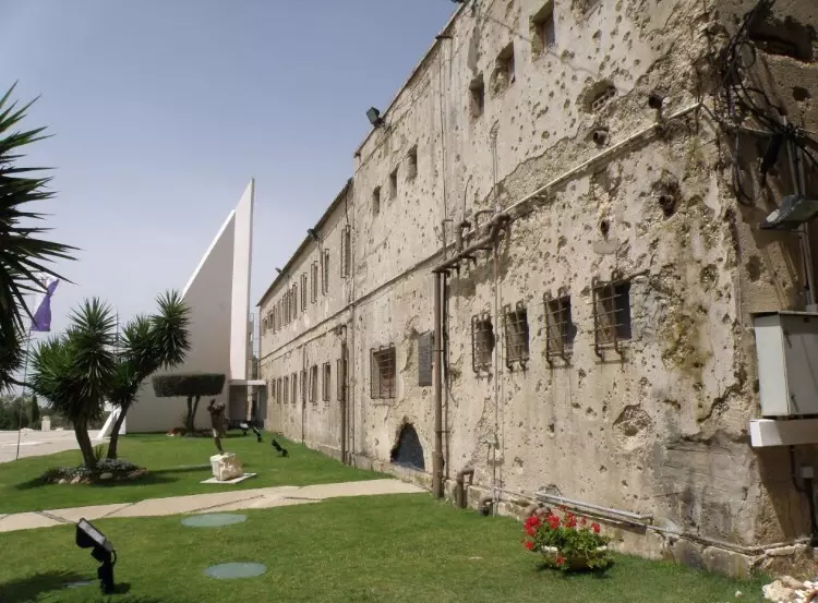
Village Before NakbaThe village stood on a small plateau of reddish-brown soil on the coastal plain. The al-Faluja–al-Majdal highway passed through its southern periphery; a fortified police station was built by the British west of the village on this same highway. The first part of its name, Iraq ('small hill' in Arabic), obviously referred to its topography. The origin of the second part, a proper name, is unknown. The village population was Muslim.In the late nineteenth century, Iraq Suwaydan was a moderate-sized village situated on a plain. After 1947 Iraq Suwaydan shared its elementary school—which the inhabitants had established as a private school in 1942—with the neighboring villages of Ibdis and Bayt Affa. Enrollment from all three villages totalled 104 students in the mid-1940s. Water for domestic use was supplied by two wells, while crops were rainfed. The main crop was grain but small areas were also planted with trees (including almond trees) and grapes. In 1944/45 a total of 7,329 dunums was allocated to cereals; 9 dunums were irrigated or used for orchards. West of Iraq Suwaydan, along the highway, were two archaeological sites: Khirbat al-Shaykh Muhammad and Khirbat al-Shaykh Abdallah. Judging from surface evidence both were intensively occupied during the Byzantine period. They contain remains such as burial places, man-made caves hewn out of the rock, and a mosaic floor. Village Occupation and Ethnic CleaningOn the eve of their evacuation on 15 May 1948, the British authorities gave the local population control over the village police station. Soon afterwards, Egyptian forces entered Palestine and the First Battalion was ordered to take up positions in Iraq Suwaydan. Because of the strategic importance of the village police station—it controlled the road between al-Majdal and Bayt Jibrin, as well as the inland road to the Negev—the Israelis tried but failed to capture it in eight separate attacks in subsequent months. In the words of the History of the War of Independence, 'There is no position in the country that we attacked as many times as that 'beast on the hill.'When the first truce was declared, the village was still unoccupied. As soon as the truce ended (which marked the beginning of the 'Ten Days'), Israeli forces again tried to capture it. Units of the Negev Brigade were ordered to capture the police station, while units of the Giv'ati Brigade were assigned the task of occupying the village itself. The village was captured briefly by the Fourth Battalion of the Giv'ati Brigade during the night of 8–9 July, according to the History of the War of Independence. But it had to be evacuated almost immediately, because units of the Negev Brigade failed to occupy the police station and the village was indefensible without it. Two days later, the New York Times reported that the Israeli air force had bombed the site, as well as other targets in the Gaza sub-disctrict. The police station finally fell on 9 November to the Ninth Battalion of the Armored Brigade in a massive attack launched during the truce in the wake of Operation Yoav, expressly designed to occupy the position. The tactic was to begin the assault with 'preparatory artillery bombardment that had been unequalled at any other time [during the war], followed by an infantry and armoured attack.' The Israeli attackers 'had never before seen such firepower aimed at a single target,' according to the History of the War of Independence. After two hours of intensive bombardment, the wall of the police station was blasted open by an advancing Israeli unit, and its Egyptian defenders, who had held out for almost six months, 'emerged from the fortress dazed and shocked, and they surrendered.' United Nations (UN) truce observers who witnessed the attack reported that the position was also bombed from the air with B-17 Flying Fortress aircraft. The New York Times reported that after hearing firing, the truce observers (an American and a Belgian) appeared on the scene with Israeli liaison officers. The Israeli officers then requested them to leave, asserting that it was dangerous to remain. The observers refused and were arrested by Israeli military police and detained until evening. The UN called the Israeli arrest of the observers a 'deliberate attempt to thwart effective truce supervision.' On 10 November, the day after the attack, an Israeli communiqué stated that following the surrender of the police fortress, Egyptian troops had withdrawn from the village of Iraq Suwaydan and the nearby village of Bayt Affa. The New York Times quoted the communiqué as saying that these villages had been occupied by Israeli soldiers, but did not say whether any of the inhabitants remained. General Yitzchaq Sadeh, the founder and first commander of the Palmach, wrote a full description of the attack on the police station of Iraq Suwaydan in which he noted: 'The name of Iraq Suweidan in itself commanded respect among the fighters of Israeli army units.' After both the village and the police station were occupied, the noose was tightened around the thousands of civilians and military personnel who remained inside the 'Faluja pocket.' Zionists Colonies on Village LandsYad Natan, an agricultural colony, was founded in 1953 to the east of the site on village lands. The settlement of Otzem was established on village land in 1955, southeast of the site. Sde Yoav, originally called Beyt Yo'av, was established to the west of the site in 1956, close to village lands.Village TodayThe debris of houses are hidden within a forest of eucalyptus trees that covers the village center. Cactuses and the remnants of a pool are visible. Two old village streets, one passing through the site and the other through the land, are clearly recognizable. The British police station is still in use and is now called Metzodat Yoav. The surrounding lands are cultivated by Israeli farmers.SourceDr. Walid al-Khalidi, 1992: All That Remains. |
|||||||||||||
| Related Maps | Town Lands' Demarcation Maps خرائط للقضاء توضح حدود القرى والاودية Town's map on MapQuest View from satellite Help us map this town at WikiMapia |
||||||||||||
| Related Links | Wikipedia's Page Facebook Page Google Search Google For Images Google For Videos |
||||||||||||
| More Information | في كتاب كي لا ننسى في كتاب بلادنا فلسطين في كتاب النكبة والفردوس المفقود المزيد من موقع هوية |
||||||||||||
- خفقة من القلب إلى عراق السويدان
- من وحي تلك الخفقة القلبية الصادقة لعراق سويدان/ للدكتور سمير أيوب
- خفقة من القلب إلى عراق سويدان
- ليست قصة وانما خاطرة اعتزاز
- اريد ان اعرف هل عائلتي تنمتي لبلدة عراق السويدان
- تعريف بعائلة ابو زعيتر وابو سمرة
- بيان صادر عن عائلة أبو زعيتر وأبو سمرة في الوطن والشتات لإنهاء الانقسام
- قريتي ... أعذريني في زمان كثرت فيه الأعذار ؟؟؟
- كنا أطفال !!
- معلومات عن عائلة أبو سمرة و أبو زعيتر و ربيع
- نبذة تاريخية عن قرية عراق سويدان (قضاء غزة) من كتاب (كي لا ننسى)
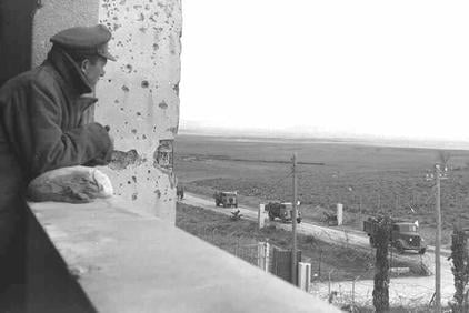
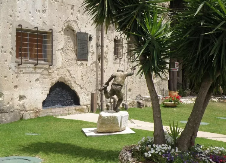
- Iraq al-Sweidan's famous police fortress, May-2002
Posted by Uri Zackhem 41 - Street Leading To The Village In 1987
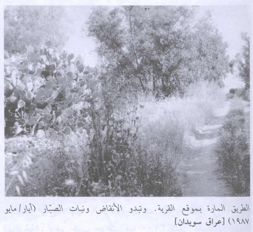
Scanned from "All That Remains" by Dr. Walid Khalidi 10 - The tower of the old police fort, 28/09/08
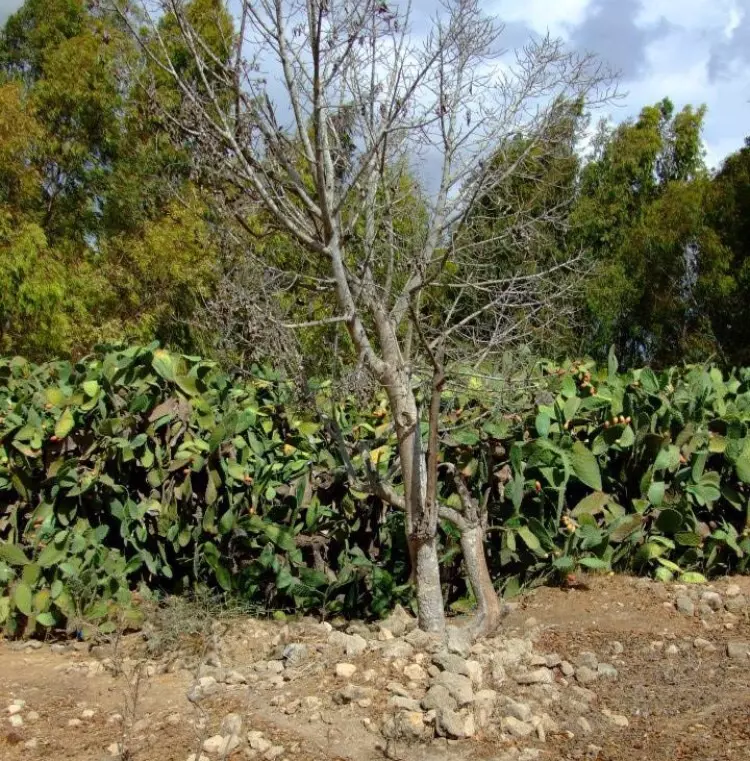
Posted by Uri Zackhem 7 - Eucalypt trees cover the hill on top of which the village used to be.
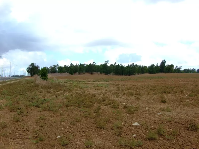
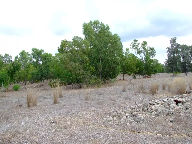
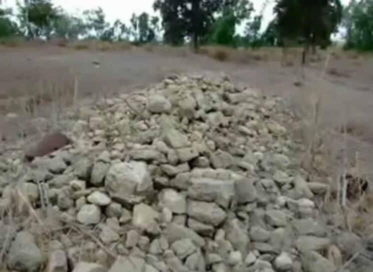
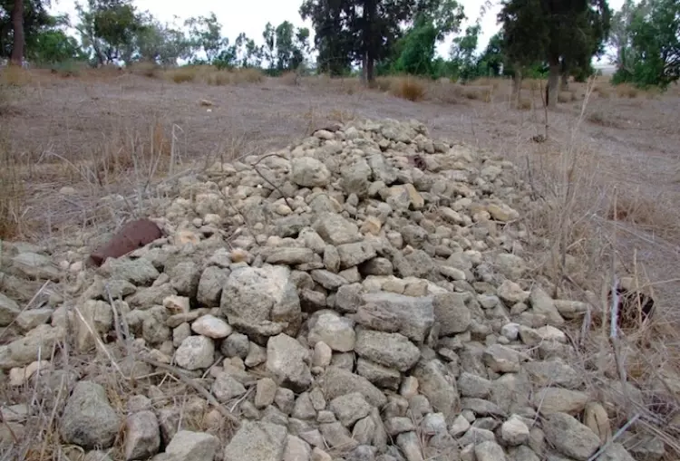
Posted by Uri Zackhem 3 - Rubble. 27/09/08

Posted by Uri Zackhem 7 - A view from the hill.
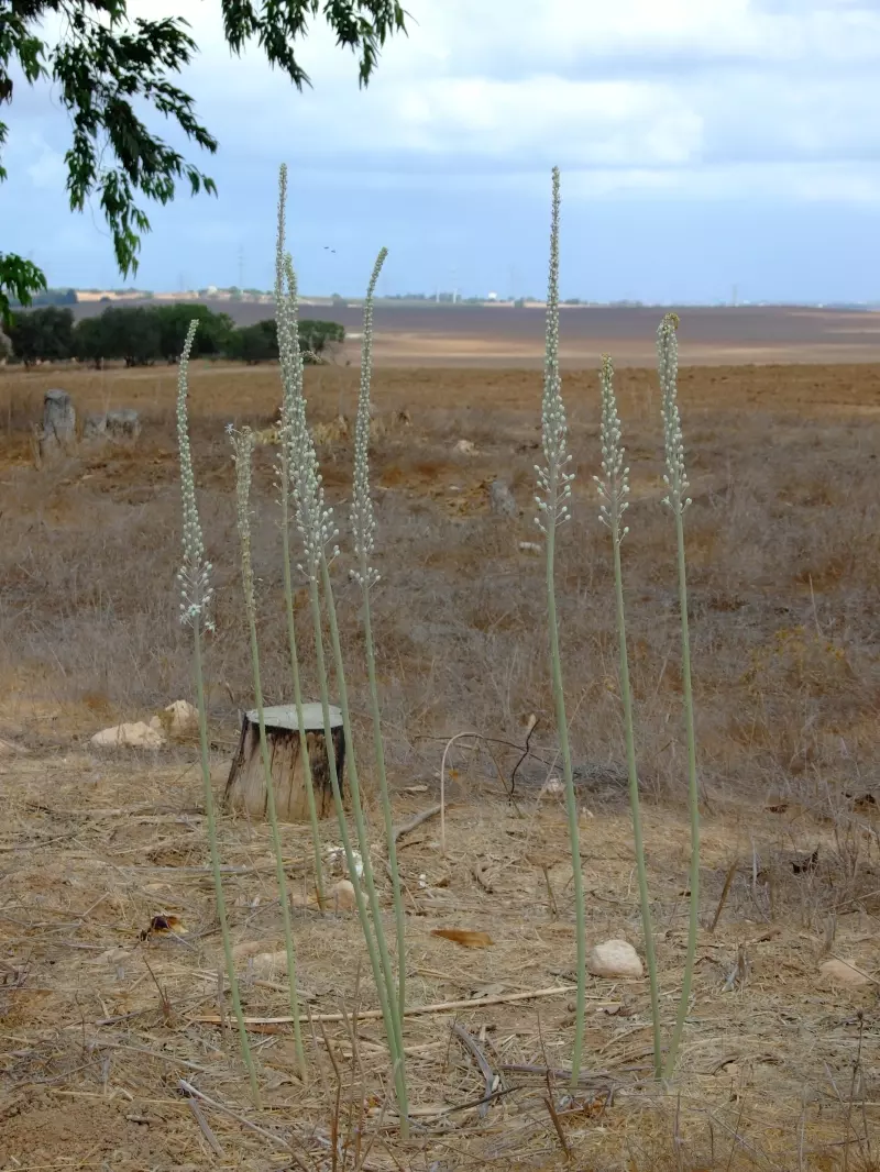
Posted by Uri Zackhem - Urginea maritima (sea quill) blossoms. 27/09/08
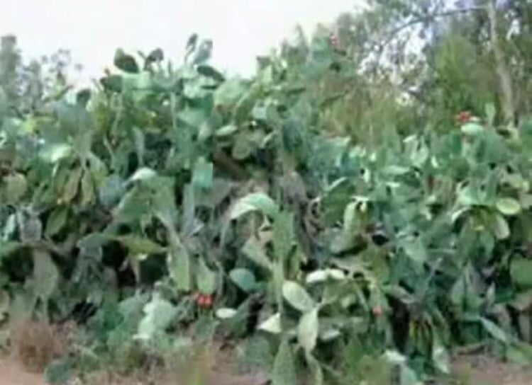
Posted by Uri Zackhem 2 - Cactus. 27/09/08
Posted by Uri Zackhem 1 - Rubble. 27/09/08
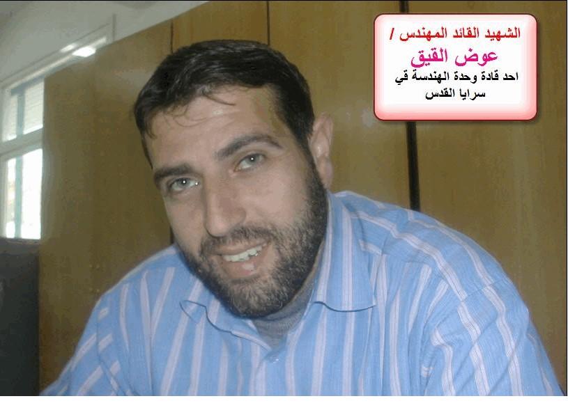
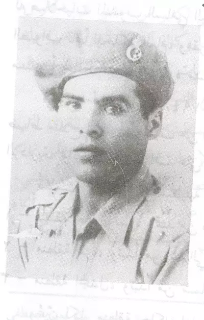
Posted by Uri Zackhem 1 - الشهيد المجاهد . عوض القيق ابن قرية عراق سويدان
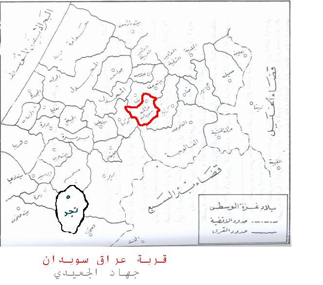
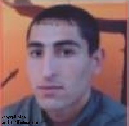
Posted by جهاد الجعيدي 2 - عراق سويدان جهاد الجعيدي
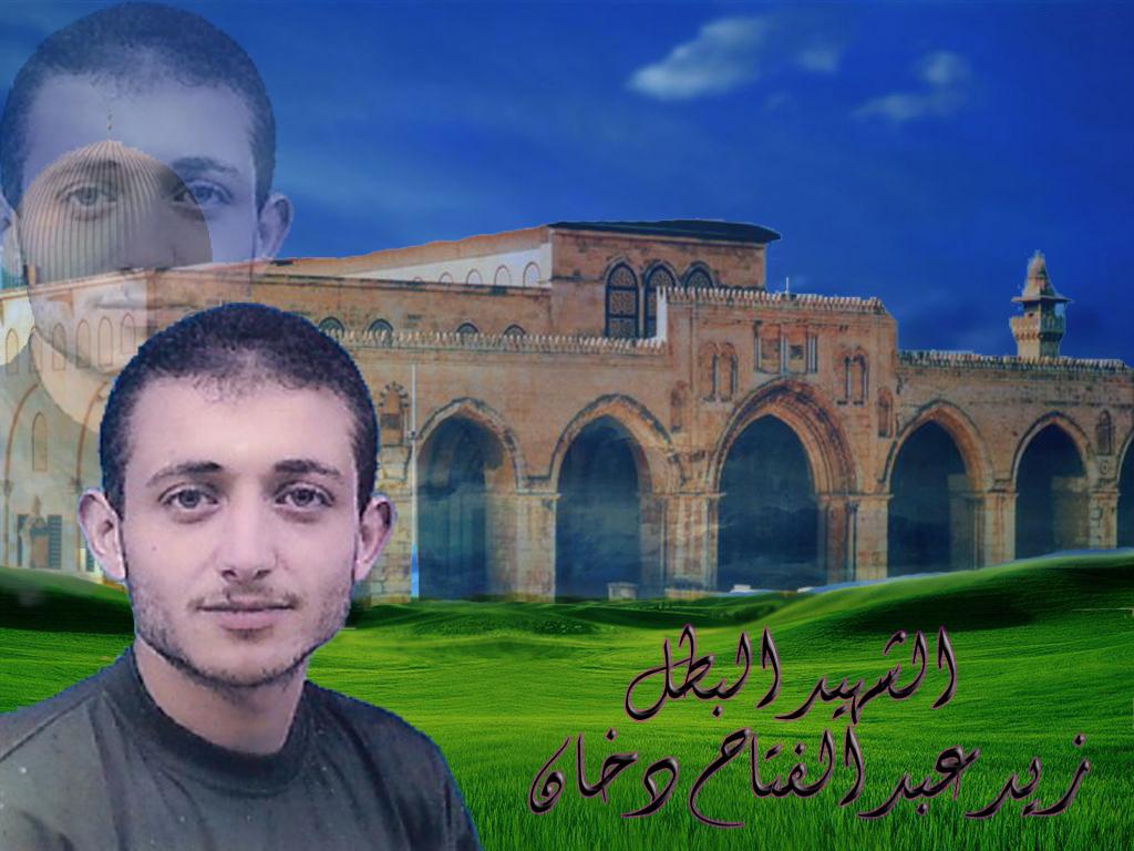
Posted by جهاد الجعيدي 1 - صورة الشهيد طارق عبد الفتاح دخان
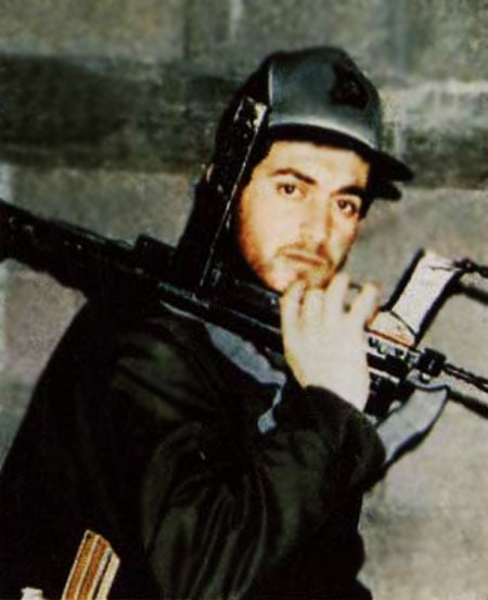
Posted by جهاد الجعيدي 3 - الشهيد المجاهد زيد عبدالفتاح دخان
Posted by جهاد الجعيدي 1 - الشهيد المجاهد ابراهيم حماد
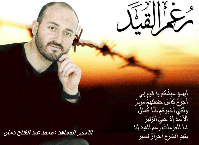
Posted by جهاد الجعيدي 1 - الاسير المجاهد : محمد عبدالفتاح دخان
Posted by جهاد الجعيدي 2 - مركز شرطة عراق سويدان الذي صد الهجمات الاسرائلية الى ان سقط بايدي اليهود بعد المحاولة التاسعة
Posted by M. S. 2 - مركز شرطة عراق سويدان الذي صد الهجمات الاسرائلية الى ان سقط بايدي اليهود بعد المحاولة التاسعة
Posted by M. S. 1 - مركز شرطة عراق سويدان الذي صد الهجمات الاسرائلية الى ان سقط بايدي اليهود بعد المحاولة التاسعة / الا ن متحف لواء جفعاتي الغاصب
Posted by M. S. 1 - صورة من عراق سويدان عام 1939 - من مواقع عبرية
Posted by M. S. 3 - الشهيد/ محمد مصطفى إبراهيم الفرا - استشهد في معركة بـ عراق سويدان 1948-05-12 ويذكر أنه من القادة الأبطال فكانت له جنازة مهيبه
Posted by M. S. 3 - مركز شرطة عراق سويدان الذي صد الهجمات الاسرائلية الى ان سقط بايدي اليهود بعد المحاولة التاسعة
Posted by M. S. - مركز شرطة عراق سويدان الذي صد الهجمات الاسرائلية الى ان سقط بايدي اليهود بعد المحاولة التاسعة
Posted by M. S. - مركز شرطة عراق سويدان الذي صد الهجمات الاسرائلية الى ان سقط بايدي اليهود بعد المحاولة التاسعة
Posted by M. S. 1 - مركز شرطة عراق سويدان الذي صد الهجمات الاسرائلية الى ان سقط بايدي اليهود بعد المحاولة التاسعة
Posted by M. S. 5 - الشهيد/ عماد حماد
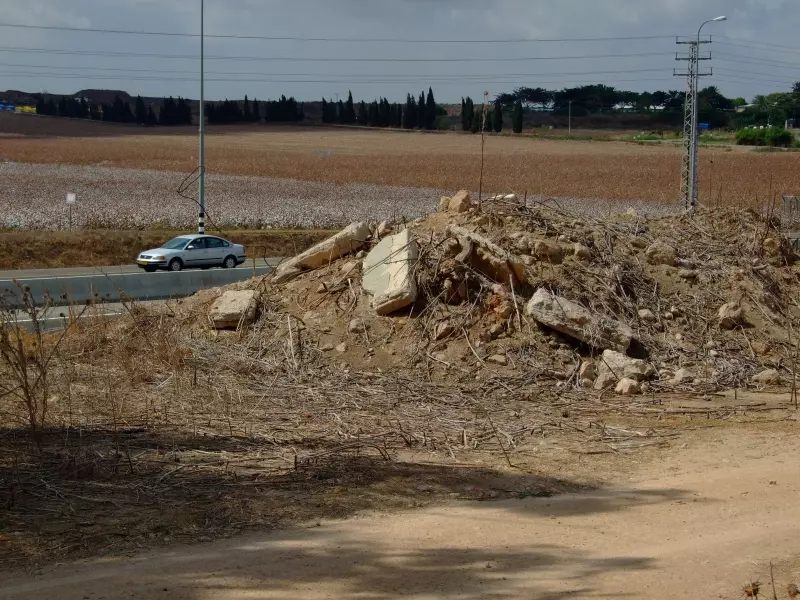
Posted by harb 1 - اثار ردم بيوت القريه
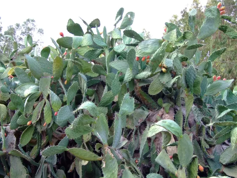
Posted by abu raya - الصبار في القريه
Posted by abu raya - عراق سويدان
Posted by abu raya - اثار ردم بيوت عراق سويدان
Posted by abu raya - الضابط الصهيوني وقواته وقت احتلال عراق سويدان 1948
Posted by abu raya - مقر شرطه عراق سويدان
Posted by abu raya - مقر الشرطه في القريه
Posted by abu raya - Pre-Nakba Aerial view of the village / صورة من الجو للقرية اخذت قبل النكبة
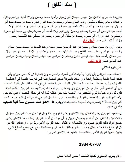
- الأصل : سند اتفاق بين عائلة "أبو زعيتر و عائلة ربيع وعائلة أبوسمرة" فريق أول
وبين "عائلة دخان" فريق ثاني
ينص الاتفاق على التعاون والتآزر في السراء والضراء بين أطراف الاتفاق
يعود الاتفاق الى عام 1934
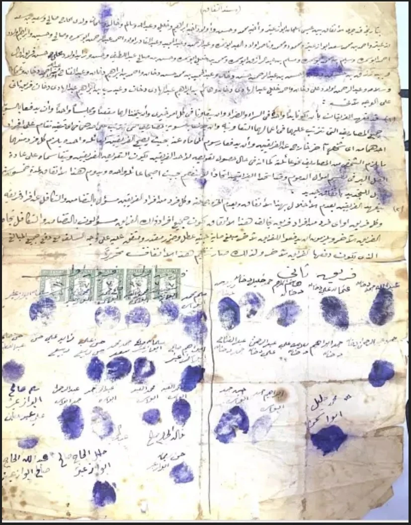
Posted by Hasan Dokhan - تفريغ كتابي: سند اتفاق بين عائلة "أبو زعيتر و عائلة ربيع وعائلة أبوسمرة" فريق أول
وبين "عائلة دخان" فريق ثاني
ينص الاتفاق على التعاون والتآزر في السراء والضراء بين أطراف الاتفاق
يعود الاتفاق الى عام 1934
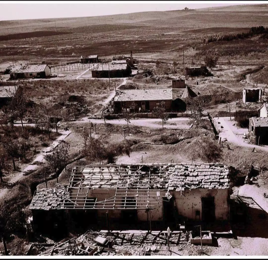
Posted by Hasan Dokhan - صورة نادرة لقرية عراق سويدان قضاء غزة بعد سقوطها في 9 تشرين الثاني/نوفمبر عام 1948..
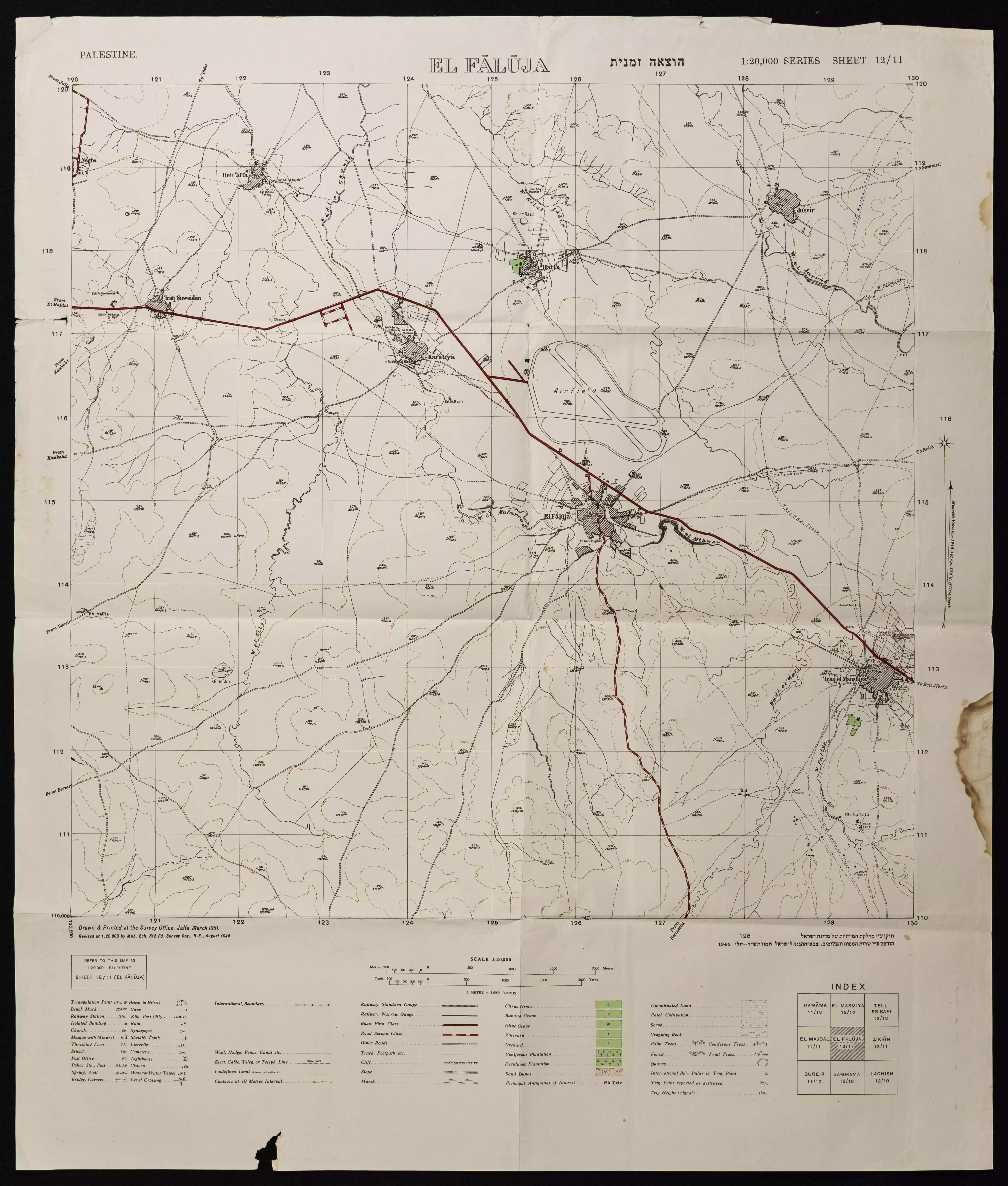
- خارطة تُظهِر الحدود والطرق بأنواعها والأماكن المقدسة والطبيعة الطوبغرافية من تلال وسهول ومنحدرات والتشكيلة الطبيعية للأرض وأنواع المزروعات. نُشرت الخريطة فترة الانتداب البريطاني، تم إضافة تعديلات عليها من قِبَل خدمة الخرائط والصور التابعة للقوات العسكرية الاسرائيلية فترة الأربعينيات.
Want to browse more? 80,000 pictures were grouped in these gallaries:
| Display Name | Clan/Hamolah | Country of Residence |
| Bahaa khlil Qasmeiah | - | - |
| mohammed Rabi | ربيع | jordan, jordan |
| Rana Fouad | Abu Samra | Norway |
| Khalid Aliyan | عليان حماد | Riyadh, KSA |
| محمدادم فريدابومرعي | ابومرعي | Berlin, Germany |
| haitham Abou Marie | - | berlin, germany |
| خليل ابراهيم مطر | أبو قاسميه | غزة, غزة |
| عائلة ابو زعيتر وابو سمرة وربيع | ابو زعيتر وابو سمرة وربيع | gaza, مخيم جباليا |
| diana | - | - |
| ياسمين عليان | عليان | عراق سويدان |
| Mohammed Zuaiter | Zuaiter | Abu-Dhabi, UNITED ARAB EMIRATES |
| mohammad ahmmad fathi hammad | حماد | عمان, عمان |
| محمد أحمد فتحي سالم حماد | حماد | عمان, عراق سويدان |
| ahmad | - | najd, saudi arabia |
| Wala'a Abu Marie | Abu Marie | ,Riyadh, KSA |
| Ala'a Abu Marie | Abu Marie | Riyadh, KSA |
| Mohammed Zuaiter | Zuaiter | United Arab Emirates |
| Ruba Abu Marie | - | Riyadh, Saudi Arabia |
| احمد فتحي سالم حماد | - | الاردن, الاردن |
| وجيه فتحي سالم محمود حماد | - | الاردن, الاردن |
| وجيه فتحي سالم محمود حماد | حماد | الاردن, الاردن |
| جهاد الجعيدي | الجعيدي | رفح, فلسطين |
| د. محمود عليان | Elian | عمان, الاردن |
| Ahmad Abdel-Qader Hammad | Hammad | Leicester, UK |
| Wael Abu Mari | - | Germany |
| Rana Abu Samra | Abu Samra | United Arab Emirates |
| lolo | عليان | السعوديه, السعوديه |
| هشام أحمد أبومرعي | أبومرعي | السالمية, الكويت |
| altima | hammad | dammam, saudia |
| خالد محمد أبومرعي | - | - |
| YOUSEF IBRAHIM MOHAMMAD ABU-MARIE | ABU-MARIE | Saudi Arabia, Saudi Arabia |
| abuzeater | - | - |
| Waseem Abou-Marie | Abou-Marie | Il, United States |
| محمد عليان | - | - |
| Rana Abu Mari | Abu Mari | - |
| Mohammad Abu Marie | أبو مرعي | Michigan, United States |
| Suzanne | El Geeg | Rafah, Palestine |
| YOSSEF SALEM | ALQIQ | Gaza, Palestine |
| SAED RABI | RABI | ABU DHABI, UNITED ARAB EMIRATES |
| Hesham SobhSalem | ALQIQ | Gaza, Palestine |
| Abdulrahman Abou-Marie | Abou-Marie | Ontario, Canada |
| Wael Zuaiter | - | - |
- الجزء الاول مقابلة تاريخ شفوي مع الراوي الفلسطيني / عبد الرحمن حسن دخان - قرية عراق سويدان - غزة
- الجزء الثاني مقابلة تاريخ شفوي مع الراوي الفلسطيني / عبد الرحمن حسن دخان - قرية عراق سويدان - غزة
- الجزء الثالث مقابلة تاريخ شفوي مع الراوي الفلسطيني / عبد الرحمن حسن دخان - قرية عراق سويدان - غزة
- الجزء الرابع مقابلة تاريخ شفوي مع الراوي الفلسطيني / عبد الرحمن حسن دخان - قرية عراق سويدان - غزة
 Fake Valor: Why Did Zionist Jews Hoist Nazis Flag on Their Ships in the 1930s?
What is new?
-
Facts About Oct. 7th Gaza Raid
-
Remined Us Please: Who Did Rape Whom? Was it Palestinians who raped Israelis? Or, was the other way around? You'll be the judge
-
When Prof. Edward Said was invited to debate Bibi Netanyahu in the 1980s, watch what happened!
-
Ezra Klein of the NY Times on the "Jewish Race".
-
Abusing Blood Libel!
-
How and why Israeli Jewry has become the most hated cult?
-
Did Israeli Soldiers Activate The Hannibal Direective On Oct. 7th? You Be The Judge
-
Zionist FAQ: Isn't it true that Palestinians don't want peace? Palestinians never accepted the two-state solution
- Facts about Haavara (Transfer) Agreement between Ben-Gurion & Hitler
-
Haavara FAQs: Why Did Zionist Jews Hoist Nazis' Flags on Their Ships in the 1930s?
- Haavara FAQs: When Chaim Weizmann met FDR in mid-1943, why was he silent about rescuing European Jewry?
-
Dear ChatGPT: How did Palestinians resist Napoleon's invasion of their country in 1799?
-
Dear ChatGPT: Gaza had a vibrant Jewish community in the mid-17th century. What happened to them?
-
Dear ChatGPT: Why did the Jewish Agency suppress news of the Holocaust during WWII?
-
Video Playlist: Jews share their DNA tests to end the conflict for good.
-
A Tale of Two Conflicts: Examining the Definition of Genocide
-
Prof. Abraham Polak And The Suppressed History of the Khazars and European Jewry
-
How Ronald Reagan would have framed the genocide in Gaza if he were still alive?
-
Haavara FAQs: Let us do the math: how many German Jews did The Haavara Agreement save?
-
Zionist FAQs: The Hebron Massacre of 1929, "clearly proves" that Palestinians are antisemitic, how could you deny it?
-
Zionist FAQs: Why Anti-Zionist Is Not Antisemitism?
-
Zionist FAQs: Isn't it true that the KGB created Palestinian Nationalism in the early 1960s?
- Zionist FAQs: Muslims are killing Muslims all the time; why are Israeli Jews being singled out in the media?
- Zionist FAQs: How is Israel an apartheid state when 20% of its citizens are Arabs who enjoy full rights?
-
Haavara FAQs: Why Did Dorothy Thompson Flip From A Zionist Advocate to A Silenced Dissenter?
-
Haavara FAQs: Analysis of Herzl's Uganda Scheme and how it could have saved millions of Jews.
-
Haavara FAQs: Why did Hayim Greenberg describe American Jewry as "morally bankrupt" in early 1943?
-
Haavara FAQs: What if the Evian Conference was a resounding success? What would have been the impact of saving European Jewry on Zionism?
- Haavara FAQs: What if the six million were saved, how that would have impacted the Zionist project?
-
Haavara FAQs: How did Zionist leaders react when Europe's Jews lingered in the DP camps after WWII ended?
-
Why does the American Jewish community repeat lies that David Ben-Gurion had debunked before he died?
-
Who has the power to rename the Tatar/Khazar Gene Marker to Jewish IV?
-
Zionist FAQs: Why won't Egypt, Syria, and Jordan take their people back? Jews are indigenous to Palestine, and Arabs immigrated after Jews developed the country. Arabs should leave.
-
Haavara FAQs: Did Hitler and the Nazis conflate between Judaism and Zionist? If that wasn't case, then why?
-
Haavara FAQs: Winston Churchill and antisemitism, a collection of articles written Churchill.
-
Haavara FAQs: Broken by country, how many Jews survived vs. killed during the Holocaust?
-
Haavara FAQs: Why did European Jews vote with their feet and to immigrated to the Americas, not Palestine, after WWII?
-
Watch this American Jewish Girl describing Israeli Jews' cognitive dissonance like no other in under two minutes
-
Haavara FAQs: When the Nazis went out of their way to hide the Holocaust, Israeli Jews did the exact opposite by broadcasting their genocide of Gazans. But why?
-
Haavara FAQs: How Zionist Jews went out of their to show their appreciation to Nazism and Fascism?
- Haavara FAQs: Why Zionist leaders were against bombing the death camps & the Railroads leading to them?
-
Haavara FAQs: Hitler's message to the British and American people: If Jews are such noble citizens and you care about them, how come you're not letting them in? I will gladly ship them to you at my expense, even on luxury liners!
-
A shortlist of Zionist and Israeli false flag operations in the name Jews.
-
The Most Moral Army
- The Land of Kapos (Israel): Where the brave are boycotted and Kapos walk free.
- Why did early Zionists often named their communal enterprises "colonial"?
- Zionist Relations with Nazi Germany by Faris Glubb
-
Two NY Times advertisements by Zionists in the early 1943 that exposes Zionists' treason at the height of the calamity
- Facts Not Lies about the Palestinian-Israeli Conflict.
- Site's pictures have been categorized
- Campgain Against Lice
- A Survey of Palestine, the official source about Palestine before Nakba produced by the British Mandate; over 1200 pages.
- Satellite View & Google Earth: Over 6,000 placemarks identifying all destroyed towns, W. Bank & Gaza Strip Towns, & refugee camps.
- PalestineRemembered.com and its Nakba Oral History Project were featured on al-Jazeera Satellite TV.
- Nakba Oral History Video Podcast:
 Over 700 Oral History interviews (including 3,500+ hours of recording) can be viewed online.
 - Palestine Village Statistics Project
- Gaza Jail Break
- النسخة العربية للموقع الان متوفرة
- Videos: Documenting the destroyed villages in video: Tracing all that remains since Nakba.
- Videos: Responding to Zionist Propaganda
- Interview: The ethnic cleansing of Palestine: George Galloway interviews Israeli Historian Ilan Pappe.
- For Palestinians, memory matters. It provides a blueprint for their future By George Bisharat.
- Zionist FAQ now available in Hebrew שאלות שציונים שואלים, עכשיו בעברית
- Video: The Stephen Walt and John Mearsheimer report on the influence of the Israel Lobby on U.S. Foreign Policy
- The Palestinian-Israeli conflict for beginners
