| PalestineRemembered | About Us | Oral History | العربية | |
| Pictures | Zionist FAQs | Haavara | Maps | |
| Search |
| Camps |
| Districts |
| Acre |
| Baysan |
| Beersheba |
| Bethlehem |
| Gaza |
| Haifa |
| Hebron |
| Jaffa |
| Jericho |
| Jerusalem |
| Jinin |
| Nablus |
| Nazareth |
| Ramallah |
| al-Ramla |
| Safad |
| Tiberias |
| Tulkarm |
| Donate |
| Contact |
| Profile |
| Videos |
Welcome To al-Khalasa - الخلصة
|
District of Beersheba
Ethnically cleansed days ago |
العربية Google Earth |
| Gallery (39) |
- Statistics & Facts
- Satellite View
- Articles 1
- Pictures 39
- Members
- Wikipedia
- Videos 1
- Guest Book 1
- Links
| Statistic & Fact | Value |
| Occupation Date | Possibly end of October, 1948 |
| Distance From District | 23 (km) Southwest of Beersheba |
| Elevation | 225 (meters) |
| Map Location | See location #3 on the map View from satellite |
| Military Operation | Operation Yo'av |
| Attacking Units | Negev Brigade |
| Defenders | Egyptian Army and Local volunteers. |
| Village Temains | The village was completely destroyed with the exception of few deserted and partially destroyed houses. |
| Ethnically Cleansing | al-Khalasa inhabitants were completely ethnically cleansed. |
| Town's Name Through History | Nabateans referred to al-Khalasa by Elusa. |
| Schools | al-Khalasa had an elementary school for boys which was founded in 1941. |
| Archeological Sites | al-Khalasa contains a ruined town, inscribed architectural fragments, tombs, Nabatean theater and the remains of the largest church in the Negev. |
| Exculsive Jewish Colonies Who Usurped Village Lands |
Village lands are being used by the Israelis Army as a military training grounds. |
| Featured Video | |
Village TodayAccording to the Palestinian historian Walid Khalidi, the village remaining structures on the village land are:"Some of the village houses are still standing but are deserted and partially destroyed. To the west of the village site is a well that is still functional, with a round mouth and metal ladder. A large house with a rectangular outline and eight rooms stands several meters away, to the west of the well. Behind it one can see the rubble of ten destroyed houses." |
|
| Related Maps | Town Lands' Demarcation Maps خرائط للقضاء توضح حدود القرى والاودية Town's map on MapQuest View from satellite Help us map this town at WikiMapia |
| Related Links | Wikipedia's Page Google Search Google For Images Google For Videos |
| More Information | في كتاب كي لا ننسى المزيد من موقع هوية |
- Village well, currently it's in use by Israeli framers, 1990
Scanned from "All That Remains" by Dr. Walid Khalidi 3 - Remains of a village houses, 1990
Scanned from "All That Remains" by Dr. Walid Khalidi 2 - Remains of a village house, 1990
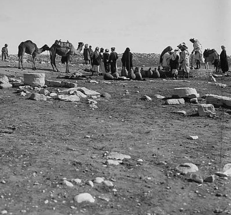
Scanned from "All That Remains" by Dr. Walid Khalidi 2 - Southern Palestine. Well at Khalasa 1900 to 1926
Posted by Joehar Hamdan - مدرسة الخلصه
Posted by محمد ألأعسم - Remains of a house, north of the main site.
Posted by Uri Zackhem - A bird on a ruin
Posted by Uri Zackhem - More of the house to the north
Posted by Uri Zackhem 1 - More of the house to the north.
Posted by Uri Zackhem 1 - More of the house to the north.
Posted by Uri Zackhem - This is probably the mill.
Posted by Uri Zackhem - This is probably the mill.
Posted by Uri Zackhem 1 - This is probably the mill.
Posted by Uri Zackhem - Village remains
Posted by Uri Zackhem - Vilage remains
Posted by Uri Zackhem - Village remains
Posted by Uri Zackhem - Graveyard, SE of the village
Posted by Uri Zackhem - Some remains across Wadi Shalala.
Posted by Uri Zackhem - The school? A garrison? A house with a courtyard, SW of the village, adjacent to a well
Posted by Uri Zackhem - A water reservoir near the well
Posted by Uri Zackhem 1 - The well
Posted by Uri Zackhem 2 - The motor was placed on this concrete slab
Posted by Uri Zackhem - Remains of the Nabatean western church.
Posted by Uri Zackhem - بيوت القريه
Posted by abu raya - بيوت القريه
Posted by abu raya - الخلصه
Posted by abu raya - اثار ردم بيوت القريه
Posted by abu raya - الباقي من بيوت القريه
Posted by abu raya - بيوت القريه
Posted by abu raya - ابار القريه
Posted by abu raya - بيوت الخلصه
Posted by abu raya - منظر عام لموقع القريه
Posted by abu raya - اثار بيوت القريه
Posted by abu raya - اراضي القريه
Posted by abu raya - بيوت القريه
Posted by abu raya - صوره قديمه من الخلاصه سنه 1917
Posted by abu raya - جولة بين انقاض القرية المدمرة قامت بها مجموعة زوخروت
- جولة بين انقاض القرية المدمرة قامت بها مجموعة زوخروت #2
- أبار الخلصة الشهيرة قبل النكبة - The well at al-Khalasa
Want to browse more? 80,000 pictures were grouped in these gallaries:
| Display Name | Clan/Hamolah | Country of Residence |
- Tracing All That Remains of al-Khalasa since Nakba Duration: 8 min 43 sec
No links have been shared yet, be free to the first to share the first link.


