| Prev | Next |  |
| Prev | Next |
| PalestineRemembered | About Us | Oral History | العربية | |
| Pictures | Zionist FAQs | Haavara | Maps | |
| Search |
| Camps |
| Districts |
| Acre |
| Baysan |
| Beersheba |
| Bethlehem |
| Gaza |
| Haifa |
| Hebron |
| Jaffa |
| Jericho |
| Jerusalem |
| Jinin |
| Nablus |
| Nazareth |
| Ramallah |
| al-Ramla |
| Safad |
| Tiberias |
| Tulkarm |
| Donate |
| Contact |
| Profile |
| Videos |
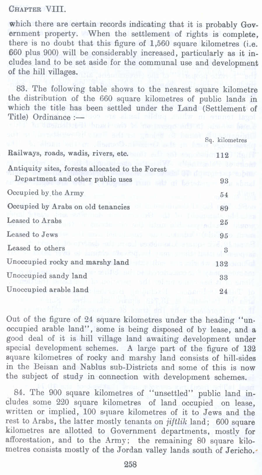
Table Showing State Lands in Palestine before 1948 (Nakba), British Mandate: A Survey of Palestine: Volume I - Page 258. Chapter VIII: Land: Section 5: The Public Lands of Palestine |
Disclaimer
The above documents, article, interviews, movies, podcasts, or stories reflects solely the research and opinions of its authors. PalestineRemembered.com makes its best effort to validate its contents.


Post Your Comment
*It should be NOTED that your email address won't be shared, and all communications between members will be routed via the website's mail server.
which there are certain records indicating that it is probably Government property. When the settlement of rights is complete, there is no doubt that this figure of 1,560 square kilometres (i.e. 660 plus 900) will be considerably increased, particularly as it includes land to be set aside for the communal use and development of the hill villages.
83. The following table shows to the nearest square kilometre the distribution of the 660 square kilometres of public lands in which the title has been settled under the Land (Settlement of Title) Ordinance :-
Railways, roads, wadis, rivers, etc.
Antiquity sites, forests allocated to the Forest
Department and other public uses
Occupied by the Army
Occupied by Arabs on old tenancies Leased to Ar abs
Leased to Jews
Leased to others
Unoccupied rocky and marshy land Unoccupied sandy land
Unoccupied arable land
Sq. kilometrea
112
93
54
89
25
95
3
132
33
24 Out of the figure of 24 square kilometres under the heading "unoccupied arable land", some is being disposed of by lease, and a good deal of it is hill village land awaiting development under special development schemes. A large part of the figure of 132 square kilometres of rocky and marshy land consists of hill-sides in the Beisan and Nablus sub-Districts and some of this is now the subject of study in connection with development schemes.
84. The 900 square kilometres of "unsettled" public land includes some 220 square kilometres of land occupied on lease, written or implied, 100 square kilometres of it to Jews and the rest to Arabs, the latter mostly tenants on jiftlik land; 600 square kilometres are allotted to Government departments, mostly for afforestation, and to the Army; the remaining 80 square kilometres consists mostly of the Jordan valley lands south of Jericho.•
Page 258