| PalestineRemembered | About Us | Oral History | العربية | |
| Pictures | Zionist FAQs | Haavara | Maps | |
| Search |
| Camps |
| Districts |
| Acre |
| Baysan |
| Beersheba |
| Bethlehem |
| Gaza |
| Haifa |
| Hebron |
| Jaffa |
| Jericho |
| Jerusalem |
| Jinin |
| Nablus |
| Nazareth |
| Ramallah |
| al-Ramla |
| Safad |
| Tiberias |
| Tulkarm |
| Donate |
| Contact |
| Profile |
| Videos |
Welcome To al-Zawiya, Khirbat - خربة الزاويه (البشاتوة) (ח'ירבת א-זאויה)
|
District of Baysan
Ethnically cleansed days ago |
العربية Google Earth |
| Gallery (5) |
- Statistics & Facts
-
Before & After

- Satellite View
- Articles 1
- Pictures 5
- Oral History 1
- Members 1
- All That Remains
- Videos
- Guest Book 1
- Links
| Statistic & Fact | Value |
| Occupation Date | May 15th-18th, 1948 |
| Distance From District | 11.5 km Northeast of Baysan |
| Elevation | -190 (meters) |
| Before & After Nakba, Click Map For Details |
|

|
|
| Map Location | See location #8 on the map View from satellite |
| Military Operation | Operation Gideon |
| Attacking Units | Golani Brigade |
| Village Temains | Khirbat al-Zawiya was completely obliterated and defaced. |
| Ethnically Cleansing | al-Zawiya, Khirbat inhabitants were completely ethnically cleansed. |
| Archeological Sites | The Cusader Castle Belvoir is located close to the village. |
| Exculsive Jewish Colonies Who Usurped Village Lands |
No Israeli settlements on village lands |
| Featured Video | |
Village Before NakbaThe village was located at the foot of the steep slope that led to Kawkab al-Hawa, a nearby village that had occupied the Crusader castle of Belvoir (see Kawkab al-Hawa, Baysan sub-district). Many minor wadis flowed down the slope into the Jordan Valley and passed the village. Khirbat al-Zawiya was classified as a hamlet by the Palestine Index Gazetteer. About 200 km south of the village was Khirbat al-Zawiyan the foundations of abandoned structures buried beneath its soil protruded from its surface.Village Occupation and Ethnic CleaningThe village was probably occupied at the same time as Kawkab al-Hawa, in the second half of May 1948, following the fall of Baysan. This would have been accomplished at the hands of the Golani Brigade, which conquered and systematically 'cleared' the Baysan Valley of its Palestinian inhabitants in May 1948. Referring to the Baysan Valley, Jewish National Fund official Yosef Weitz declared in early May: 'The evacuation [of the Arabs] from the Valley is the order of the day.' The village probably remained in Israeli hands for the duration of the war, since Arab forces that entered the country in this area were unable to recapture much territory.Zionists Colonies on Village LandsThere are no Israeli settlements on village lands.Village TodayCactuses grow throughout the site, which has been turned into a grazing area. The Kawkab al-Hawa fortress overlooks the village from the northeast.SourceDr. Walid al-Khalidi, 1992: All That Remains. |
|
| Related Maps | Town Lands' Demarcation Maps خرائط للقضاء توضح حدود القرى والاودية Town's map on MapQuest View from satellite Help us map this town at WikiMapia |
| More Information | في كتاب كي لا ننسى |
- Village Site General View In 1987
Scanned from "All That Remains" by Dr. Walid Khalidi - خربه الزاويه . موقع القريه
Posted by abu raya - اراضي القريه وجسر قطار الحجاز
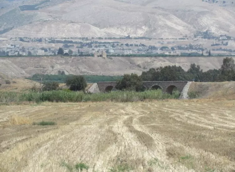
Posted by abu raya - جسر على وادي البيره لخط قطار حيفا الحجاز بالقرب من القريه
Posted by abu raya - وثيقة عثمانية تُظهر منطقة بيسان ونهر الشريعة وحدود أراضي عرب البشاتوة، وقد صادقت عليها الدولة العثمانية رسميًا في سجل الطابو في العام 1898. ويظهر في الخارطة اسمي الشيخين فضل الفاهوم وسعيد بكار.
المصادر: الدار السلطانية للوثائق العثمانية
Posted by M.albeshtawi
Want to browse more? 80,000 pictures were grouped in these gallaries:
| Display Name | Clan/Hamolah | Country of Residence |
| اياد البشتاوي | البشتاوي | - |
No links have been shared yet, be free to the first to share the first link.


