| PalestineRemembered | About Us | Oral History | العربية | |
| Pictures | Zionist FAQs | Haavara | Maps | |
| Search |
| Camps |
| Districts |
| Acre |
| Baysan |
| Beersheba |
| Bethlehem |
| Gaza |
| Haifa |
| Hebron |
| Jaffa |
| Jericho |
| Jerusalem |
| Jinin |
| Nablus |
| Nazareth |
| Ramallah |
| al-Ramla |
| Safad |
| Tiberias |
| Tulkarm |
| Donate |
| Contact |
| Profile |
| Videos |
Welcome To Zab'a - زبعة (זבעה)
|
District of Baysan
Ethnically cleansed days ago |
العربية Google Earth |
| Gallery (9) |
- Statistics & Facts
-
Before & After

- Satellite View
- Articles 1
- Pictures 9
- Members
- All That Remains
- Wikipedia
- Videos 1
- Guest Book
- Links
| Statistic & Fact | Value | |||||||||||||||
| Occupation Date | May 12, 1948 | |||||||||||||||
| Distance From District | 5.5 km Northeast of Baysan | |||||||||||||||
| Elevation | -225 (meters) | |||||||||||||||
| Before & After Nakba, Click Map For Details |
||||||||||||||||

|
||||||||||||||||
| Map Location | See location #14 on the map View from satellite |
|||||||||||||||
| Military Operation | Opeartion Gideon | |||||||||||||||
| Village Temains | The village was completely defaced | |||||||||||||||
| Ethnically Cleansing | Zab'a inhabitants were completely ethnically cleansed. | |||||||||||||||
| Pre-Nakba Land Ownership |
**Town Lands' Demarcation Maps |
|||||||||||||||
| Land Usage As of 1945 |
|
|||||||||||||||
| Population |
|
|||||||||||||||
| Number of Houses |
|
|||||||||||||||
| Near By Towns |
||||||||||||||||
|
||||||||||||||||
| Nearby Wadies & Rivers | The village is situated on Wadi Yubla or Wadi al-'Ashsha (the same wadi has two names). | |||||||||||||||
| Archeological Sites | Zab'a contains Tall Isma'il which was used by a local Bedouins tribe as a cemetery. | |||||||||||||||
| Exculsive Jewish Colonies Who Usurped Village Lands |
Beyt Yosef & Doshe | |||||||||||||||
| Featured Video | ||||||||||||||||
Village Before NakbaThe village was located on Wadi Yubla (also called Wadi al-'Ashsha), at the point where the wadi entered the Jordan Valley area. Both the Baysan-Jericho highway and the railway line leading from Haifa to Samakh (and ultimately to the Hijaz railway) passed directly to the east. The village, which was classified as a hamlet by the Palestine Index Gazetteer, had a rectangular plan. Its adobe houses and narrow alleys ran from northwest to southeast, away from the wadi; they may have been laid out in this pattern so that they would not be flooded in winter.The village's location, the richness of its soil, and its abundant water supplies made it an early target for takeover by the Zionists during the British Mandate. Zab'a's inhabitants, all of whom were Muslims, were successful farmers and grew vegetables, fruit, and grain before their land was acquired by Jewish settlers. In 1944/45 all of the 156 dunums that were left in the hands of the villagers were allocated to cereals. Two km east of the village was Tall Isma'il, on top of which was a Bedouin cemetery. Because the soil of such mounds, which contain the remains of earlier settlements, is soft, they are attractive to Bedouin as cemetery sites. Zionists Colonies on Village LandsIn 1937 Zionists established the settlement of Beyt Yosef some 2 km northeast of the village site, on land that they had purchased but that had once belonged to the village. Doshen, a farm belonging to the 'Yitzur ve-Pittu'ach' organization, was established in 1955 on village land, close to the village site.Village TodayThe site is covered with grass, lotus trees, and stones. Israelis have established several agricultural projects and fisheries on the village land. Other parts of the surrounding land are used for grazing.SourceDr. Walid al-Khalidi, 1992: All That Remains. |
||||||||||||||||
| Related Maps | Town Lands' Demarcation Maps خرائط للقضاء توضح حدود القرى والاودية Town's map on MapQuest View from satellite Help us map this town at WikiMapia |
|||||||||||||||
| Related Links | Wikipedia's Page Google Search Google For Images Google For Videos |
|||||||||||||||
| More Information | في كتاب كي لا ننسى في كتاب بلادنا فلسطين المزيد من موقع هوية |
|||||||||||||||
- Village Site General View In 1987
Scanned from "All That Remains" by Dr. Walid Khalidi - اراضي القريه وخط حيفا الحجاز يمر من جنوبها
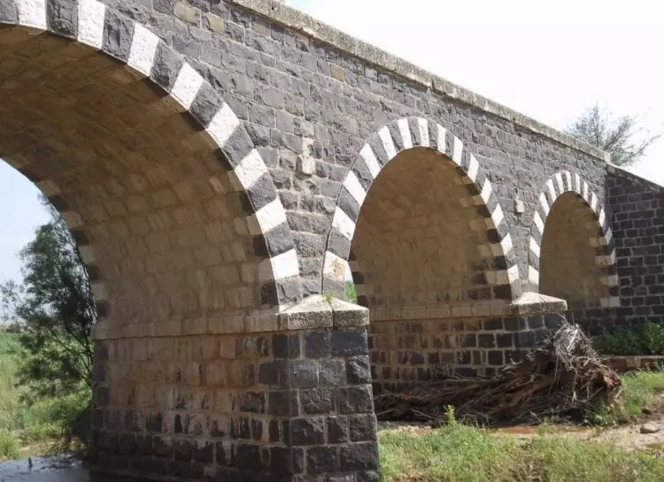
Posted by abu raya - نهر الجالود وجسر قطار الحجاز من جنوب القريه
Posted by abu raya - موقع القريه والمستوطنه المقامه مكانها
Posted by abu raya - نهر الجالود وجسر قطار الحجاز
Posted by abu raya - جسر قطار الحجاز يمر من القريه
Posted by abu raya - اراضي القريه
Posted by abu raya - اراضي القريه
Posted by abu raya - خط حيفا الحجاز يمر من القريه
Posted by abu raya
Want to browse more? 80,000 pictures were grouped in these gallaries:
| Display Name | Clan/Hamolah | Country of Residence |
No links have been shared yet, be free to the first to share the first link.


