| PalestineRemembered | About Us | Oral History | العربية | |
| Pictures | Zionist FAQs | Haavara | Maps | |
| Search |
| Camps |
| Districts |
| Acre |
| Baysan |
| Beersheba |
| Bethlehem |
| Gaza |
| Haifa |
| Hebron |
| Jaffa |
| Jericho |
| Jerusalem |
| Jinin |
| Nablus |
| Nazareth |
| Ramallah |
| al-Ramla |
| Safad |
| Tiberias |
| Tulkarm |
| Donate |
| Contact |
| Profile |
| Videos |
Welcome To al-Ashrafiyya - الأشرفية (אל-אשרפיה)
|
District of Baysan
Ethnically cleansed days ago |
العربية Google Earth |
 |
Gallery (3) |
- Statistics & Facts
-
Before & After

- Satellite View
- Articles 1
- Pictures 3
- Members
- All That Remains
- Wikipedia
- Videos
- Guest Book
- Links
| Statistic & Fact | Value | ||||||||||||||||||
| Occupation Date | May 12, 1948 | ||||||||||||||||||
| Distance From District | 4.5 (km) Southwest of Baysan | ||||||||||||||||||
| Elevation | -125 (meters) | ||||||||||||||||||
| Before & After Nakba, Click Map For Details |
|||||||||||||||||||
|
|||||||||||||||||||
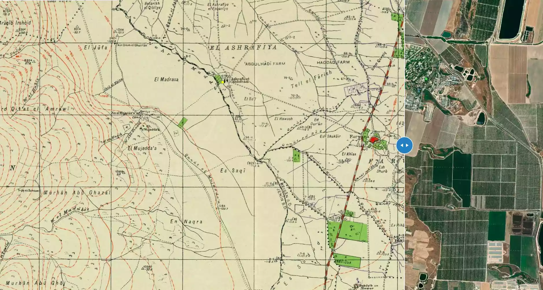
| Map Location | See location #20 on the map View from satellite |
||||||||||||||||||
| Military Operation | Operation Gideon | ||||||||||||||||||
| Attacking Units | Golan Brigades and possibly Irgun Zvai Leumi (IZL) too. | ||||||||||||||||||
| Exodus Cause | Influence of fall of, or exoduce from, neighboring town | ||||||||||||||||||
| Village Temains | The village was completely destroyed and defaced. | ||||||||||||||||||
| Ethnically Cleansing | Upon occupation, both Farwana and al-Ashrafiyya inhabitants fled towards Jordan. | ||||||||||||||||||
| Pre-Nakba Land Ownership |
|
||||||||||||||||||
| Land Usage As of 1945 |
|
||||||||||||||||||
| Population |
|
||||||||||||||||||
| Number of Houses |
|
||||||||||||||||||
| Near By Towns |
|||||||||||||||||||
|
|||||||||||||||||||
| Nearby Wadies & Rivers | The village is situated nearby Wadi al-Maddu'. | ||||||||||||||||||
| Exculsive Jewish Colonies Who Usurped Village Lands |
Reshafim & Sheluchot. | ||||||||||||||||||
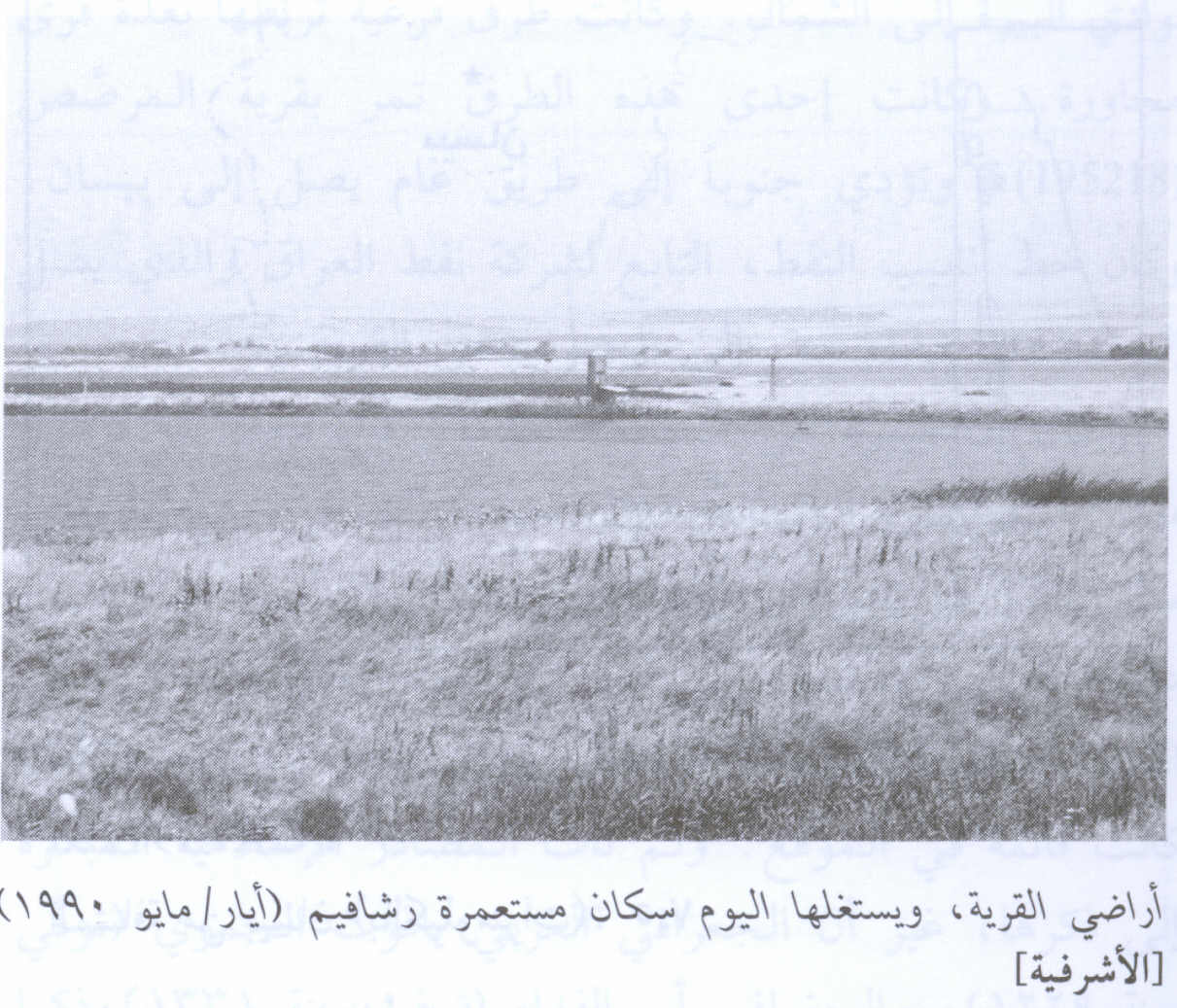
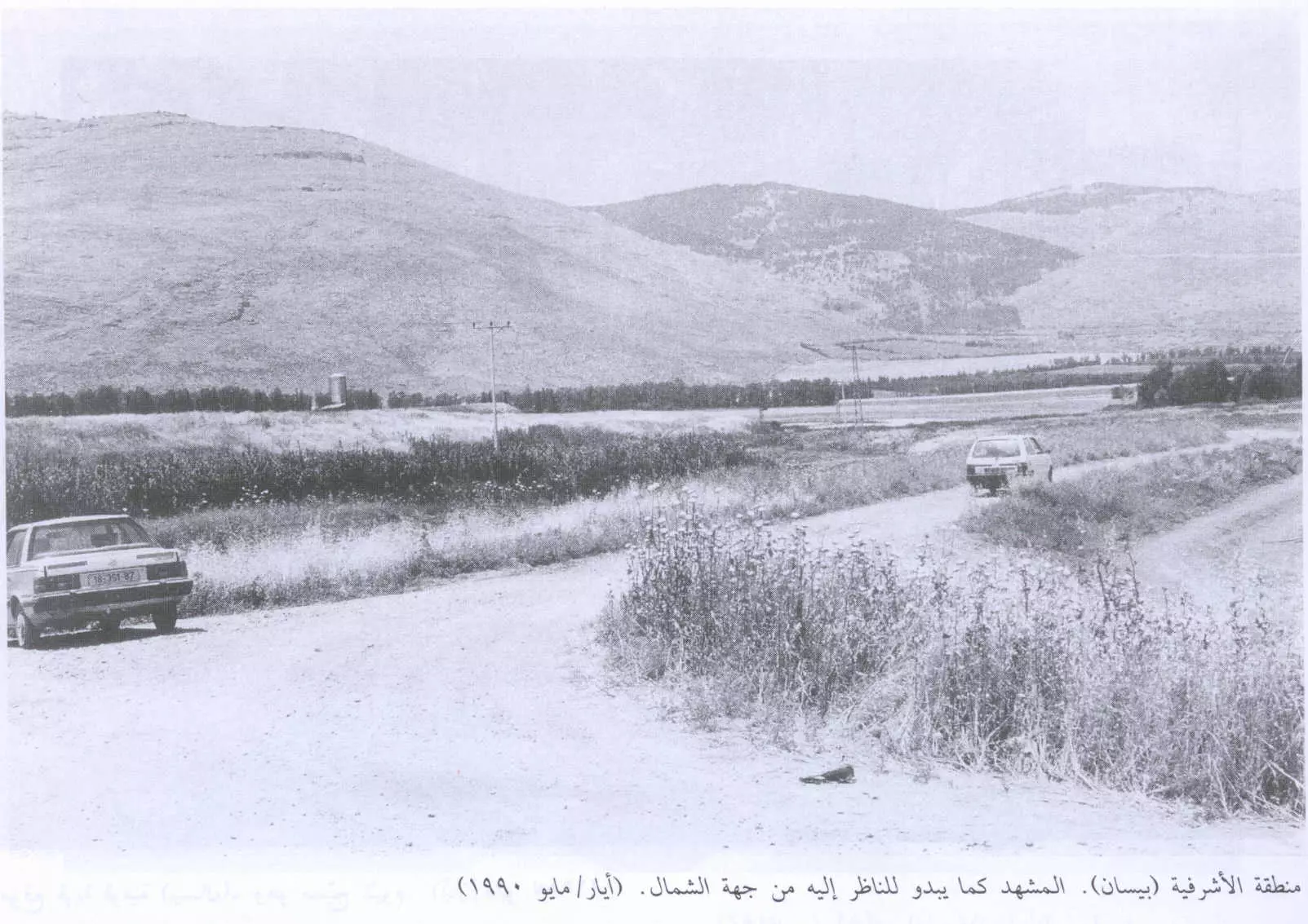
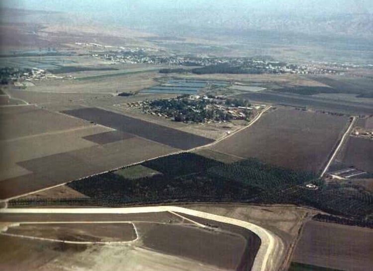
Village Before NakbaThe village stood on a flat area about 2 km to the east of the al-Faqqu'a (or Jilbu') Mountains, and overlooked low-lying lands to the north and west sides. Mount Tabor was visible in the distance on the northwest. On the eastern side the village faced the highlands east of the Jordan. This elevated location may explain the village's name, al-Ashrafiyya, which was derived from the Arabic verb "to overlook." The location also afforded the village protection from the flooding of Wadi al-Maddu', which flowed west of it. The Baysan-Jericho highway ran about 2 km east of al-Ashrafiyya, and a secondary road linked the village to this highway. It was classified as a hamlet during the Mandate era by the Palestine Index Gazetteer.The people of al-Ashrafiyya were Muslims, and built their mud houses in clusters, separated by narrow alleys. Most of its lands were cultivated, thanks to the abundance of water from rain and springs, the fertility of the soil, and the easily-tilled, level terrain. Agriculture consisted primarily of vegetables, fruit trees such as citrus and bananas, and olives. In 1944/45 a total of 143 dunums was devoted to citrus and bananas and 7 dunums were allocated to cereals; 4,458 dunums were irrigated or used for orchards. Most of the villagers worked in agriculture and animal husbandry. Village Occupation and Ethnic CleaningUnits of the Golani Brigade attacked and captured the village on the night of 10-11 May 1948 as part of Operation Gideon. The assault was undertaken as a prelude to the attack on Baysan the following day. Baysan's other "satellite village," Farwana, was occupied at the same time. Both were probably among eight villages reported captured near Baysan on 13 May, according to the Associated Press. Relying on Israeli sources, Israeli historian Benny Morris writes that the inhabitants of Farwana fled to Transjordan "as the troops approached" and that after its capture "Haganah sappers began to blow up the village houses."Zionists Colonies on Village LandsTwo settlements that were established in 1948, Reshafim and Sheluchot, are located east of the village site on village land.Village TodayThe site and the area around it are cultivated by the residents of Reshafim. A fishery also has been built on the site.SourceDr. Walid al-Khalidi, 1992: All That Remains. |
|||||||||||||||||||
| Related Maps | Town Lands' Demarcation Maps خرائط للقضاء توضح حدود القرى والاودية Town's map on MapQuest View from satellite Help us map this town at WikiMapia |
||||||||||||||||||
| Related Links | Wikipedia's Page Google Search Google For Images Google For Videos |
||||||||||||||||||
| More Information | في كتاب كي لا ننسى في كتاب بلادنا فلسطين المزيد من موقع هوية |
||||||||||||||||||
Want to browse more? 80,000 pictures were grouped in these gallaries:
| Display Name | Clan/Hamolah | Country of Residence |
No links have been shared yet, be free to the first to share the first link.
 Fake Valor: Why Did Zionist Jews Hoist Nazis Flag on Their Ships in the 1930s?
What is new?
-
Facts About Oct. 7th Gaza Raid
-
Remined Us Please:: Who Did Rape Who? Palestinians Raped Israelis? Or, was the other way around?
-
When Prof. Edward Said was invited to debate Bibi Netanyahu in the 1980s, watch what happened!
-
Ezra Klein of the NY Times on the "Jewish Race".
-
Abusing Blood Libel!
-
Zionist FAQ: Isn't it true that Palestinians don't want peace? Palestinians never accepted the two-state solution
- Facts about Haavara (Transfer) Agreement between Ben-Gurion & Hitler
-
Haavara FAQs: Why Did Zionist Jews Hoist Nazis' Flags on Their Ships in the 1930s?
-
Dear ChatGPT: Why did the Jewish Agency suppress news of the Holocaust during WWII?
-
Video Playlist: Jews share their DNA tests to end the conflict for good.
-
A Tale of Two Conflicts: Examining the Definition of Genocide
-
Prof. Abraham Polak And The Suppressed History of the Khazars and European Jewry
-
How Ronald Reagan would have framed the genocide in Gaza if he were still alive?
-
Haavara FAQs: Let us do the math: how many German Jews did The Haavara Agreement save?
-
Zionist FAQs: The Hebron Massacre of 1929, "clearly proves" that Palestinians are antisemitic, how could you deny it?
-
Zionist FAQs: Why Anti-Zionist Is Not Antisemitism?
-
Zionist FAQs: Isn't it true that the KGB create Palestinian Nationalism in the early 1960s?
- Zionist FAQs: Muslims are killing Muslims all the time; why are Israeli Jews being singled out in the media?
- Zionist FAQs: How is Israel an apartheid state when 20% of its citizens are Arabs who enjoy full rights?
-
Haavara FAQs: Analysis of Herzl's Uganda Scheme and how it could have saved millions of Jews.
-
Haavara FAQs: Why did Hayim Greenberg describe American Jewry as "morally bankrupt" in early 1943?
-
Haavara FAQs: What if the Evian Conference was a resounding success? What would have been the impact of saving European Jewry on Zionism?
- Haavara FAQs: What if the six million were saved, how that would have impacted the Zionist project?
-
Haavara FAQs: How did Zionist leaders react when Europe's Jews lingered in the DP camps after WWII ended?
-
Why does the American Jewish community repeat lies that David Ben-Gurion had debunked before he died?
-
Who has the power to rename the Tatar/Khazar Gene Marker to Jewish IV?
-
Zionist FAQs: Why won't Egypt, Syria, and Jordan take their people back? Jews are indigenous to Palestine, and Arabs immigrated after Jews developed the country. Arabs should leave.
-
Haavara FAQs: Did Hitler and the Nazis conflate between Judaism and Zionist? If that wasn't case, then why?
-
Haavara FAQs: Winston Churchill and antisemitism, a collection of articles written Churchill.
-
Haavara FAQs: Broken by country, how many Jews survived vs. killed during the Holocaust?
-
Haavara FAQs: Why did European Jews vote with their feet and to immigrated to the Americas, not Palestine, after WWII?
-
Watch this American Jewish Girl describing Israeli Jews' cognitive dissonance like no other in under two minutes
-
Haavara FAQs: When the Nazis went out of their way to hide the Holocaust, Israeli Jews did the exact opposite by broadcasting their genocide of Gazans. But why?
-
Haavara FAQs: How Zionist Jews went out of their to show their appreciation to Nazism and Fascism?
- Haavara FAQs: Why Zionist leaders were against bombing the death camps & the Railroads leading to them?
-
Haavara FAQs: Hitler's message to the British and American people: If Jews are such noble citizens and you care about them, how come you're not letting them in? I will gladly ship them to you at my expense, even on luxury liners!
-
A shortlist of Zionist and Israeli false flag operations in the name Jews.
-
The Most Moral Army
- The Land of Kapos (Israel): Where the brave are boycotted and Kapos walk free.
- Why did early Zionists often named their communal enterprises "colonial"?
- Zionist Relations with Nazi Germany by Faris Glubb
-
Two NY Times advertisements by Zionists in the early 1943 that exposes Zionists' treason at the height of the calamity
- Facts Not Lies about the Palestinian-Israeli Conflict.
- Site's pictures have been categorized
- Campgain Against Lice
- A Survey of Palestine, the official source about Palestine before Nakba produced by the British Mandate; over 1200 pages.
- Satellite View & Google Earth: Over 6,000 placemarks identifying all destroyed towns, W. Bank & Gaza Strip Towns, & refugee camps.
- PalestineRemembered.com and its Nakba Oral History Project were featured on al-Jazeera Satellite TV.
- Nakba Oral History Video Podcast:
 Over 700 Oral History interviews (including 3,500+ hours of recording) can be viewed online.
 - Palestine Village Statistics Project
- Gaza Jail Break
- النسخة العربية للموقع الان متوفرة
- Videos: Documenting the destroyed villages in video: Tracing all that remains since Nakba.
- Videos: Responding to Zionist Propaganda
- Interview: The ethnic cleansing of Palestine: George Galloway interviews Israeli Historian Ilan Pappe.
- For Palestinians, memory matters. It provides a blueprint for their future By George Bisharat.
- Zionist FAQ now available in Hebrew שאלות שציונים שואלים, עכשיו בעברית
- Video: The Stephen Walt and John Mearsheimer report on the influence of the Israel Lobby on U.S. Foreign Policy
- The Palestinian-Israeli conflict for beginners
