| PalestineRemembered | About Us | Oral History | العربية | |
| Pictures | Zionist FAQs | Haavara | Maps | |
| Search |
| Camps |
| Districts |
| Acre |
| Baysan |
| Beersheba |
| Bethlehem |
| Gaza |
| Haifa |
| Hebron |
| Jaffa |
| Jericho |
| Jerusalem |
| Jinin |
| Nablus |
| Nazareth |
| Ramallah |
| al-Ramla |
| Safad |
| Tiberias |
| Tulkarm |
| Donate |
| Contact |
| Profile |
| Videos |
Welcome To al-Burj, Khirbat - خربة البرج (ח'ירבת אל-ברג')
|
District of Haifa
Ethnically cleansed days ago |
العربية Google Earth |
| Gallery (18) |
- Statistics & Facts
-
Before & After

- Satellite View
- Articles 1
- Pictures 18
- Members
- All That Remains
- Wikipedia
- Videos
- Guest Book
- Links 1
| Statistic & Fact | Value | ||||||||||||||||||
| Occupation Date | February 15, 1948 | ||||||||||||||||||
| Distance From District | 34.5 (km) South of Haifa | ||||||||||||||||||
| Elevation | 25 (meters) | ||||||||||||||||||
| Before & After Nakba, Click Map For Details |
|||||||||||||||||||

|
|||||||||||||||||||
| Map Location | See location #44 on the map View from satellite |
||||||||||||||||||
| Military Operation | Terror campaign before the start of the war | ||||||||||||||||||
| Attacking Units | Some unknown terror unit from the Haganah. | ||||||||||||||||||
| Exodus Cause | Fear of Jewish attack, or of being caught in the fighting | ||||||||||||||||||
| Village Temains | The village has been completely obliterated, only house rubble left behind. | ||||||||||||||||||
| Ethnically Cleansing | al-Burj, Khirbat inhabitants were completely ethnically cleansed. | ||||||||||||||||||
| Pre-Nakba Land Ownership |
**Town Lands' Demarcation Maps |
||||||||||||||||||
| Land Usage As of 1945 |
|
||||||||||||||||||
| Archeological Sites | Khirbat al-Burj contained khirbat Tel al-Burayj, which had the foundations of buildings and granite columns. | ||||||||||||||||||
| Exculsive Jewish Colonies Who Usurped Village Lands |
Binyamina | ||||||||||||||||||
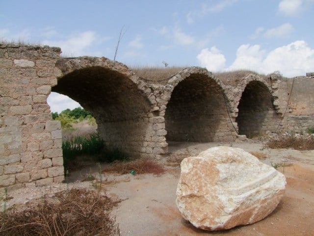
Village Before NakbaThe village stood on rolling terrain on the central coastal plain. It was known for its citrus crops. In 1944 a total of 13 dunums of village land was irrigated or used for orchards. The nearby Tall al-Burayj, an archaeological site, contained the foundations of buildings and granite columns.Village Occupation and Ethnic CleaningKhirbat al-Burj was probably seized in the early weeks of the fighting. The nearest Arab community to it was the large village of Qisarya (Caesarea), just to the west. That village was occupied and its people were expelled in mid-February 1948, in the context of an operation designed to render a large swath of coastal territory empty of Arabs in the first few months of the war. By the end of March, many coastal communities between Tel Aviv and Zikhron Ya'aqov had been attacked in a series of raids carried out by Zionist forces. These resulted in driving out entire communities, sometimes through direct expulsion and sometimes through fear of attack, according to Israeli historian Benny Morris.Zionists Colonies on Village LandsThe settlement of Binyamina was established in 1922 near the village site, to the north. It is not, however, on village lands.Village TodayMuch of the site is covered by rubble, which lies amid the grass and cactus plants. The walls of a large stone building (possibly a khan ) are still standing. The surrounding lands are used by Israeli farmers for citrus cultivation.SourceDr. Walid al-Khalidi, 1992: All That Remains. |
|||||||||||||||||||
| Related Maps | Town Lands' Demarcation Maps خرائط للقضاء توضح حدود القرى والاودية Town's map on MapQuest View from satellite Help us map this town at WikiMapia |
||||||||||||||||||
| Related Links | Wikipedia's Page Google Search Google For Images Google For Videos |
||||||||||||||||||
| More Information | في كتاب كي لا ننسى |
||||||||||||||||||
- khirbat a burj khan all that remains
Posted by farid haj yahya - khirbat a burj khan all that remains
Posted by farid haj yahya - khirbat a burj khan all that remains
Posted by farid haj yahya - khirbat a burj khan all that remains
Posted by farid haj yahya - khirbat a burj khan all that remains
Posted by farid haj yahya - khirbat a burj khan all that remains
Posted by farid haj yahya - khirbat a burj khan all that remains
Posted by farid haj yahya - khirbat a burj khan all that remains
Posted by farid haj yahya - khirbat a burj khan all that remains
Posted by farid haj yahya - khirbat a burj khan all that remains
Posted by farid haj yahya 1 - khirbat a burj khan all that remains
Posted by farid haj yahya - khirbat a burj khan all that remains
Posted by farid haj yahya - خربه البرج
Posted by abu raya - اراضي خربه البرج
Posted by abu raya - مسجد خربه البرج
Posted by abu raya - اراضي خربه البرج
Posted by abu raya - مسجد خربه البرج
Posted by abu raya - اراضي خربه البرج
Posted by abu raya
Want to browse more? 80,000 pictures were grouped in these gallaries:
| Display Name | Clan/Hamolah | Country of Residence |


