| PalestineRemembered | About Us | Oral History | العربية | |
| Pictures | Zionist FAQs | Haavara | Maps | |
| Search |
| Camps |
| Districts |
| Acre |
| Baysan |
| Beersheba |
| Bethlehem |
| Gaza |
| Haifa |
| Hebron |
| Jaffa |
| Jericho |
| Jerusalem |
| Jinin |
| Nablus |
| Nazareth |
| Ramallah |
| al-Ramla |
| Safad |
| Tiberias |
| Tulkarm |
| Donate |
| Contact |
| Profile |
| Videos |
Welcome To al-Ghubayya al-Tahta - الغبية التحتا (אל-ע'וביה א-תחתא)
|
District of Haifa
Ethnically cleansed days ago |
العربية Google Earth |
 |
Gallery (3) |
- Statistics & Facts
-
Before & After

- Satellite View
- Articles 2
- Pictures 3
- Oral History 1
- Members 6
- All That Remains
- Wikipedia
- Videos
- Guest Book 2
- Links 1
| Statistic & Fact | Value | ||||||||||
| Occupation Date | April 8, 1948 | ||||||||||
| Distance From District | 28 (km) South East of Haifa | ||||||||||
| Elevation | 110 (meters) | ||||||||||
| Before & After Nakba, Click Map For Details |
|||||||||||
|
|||||||||||
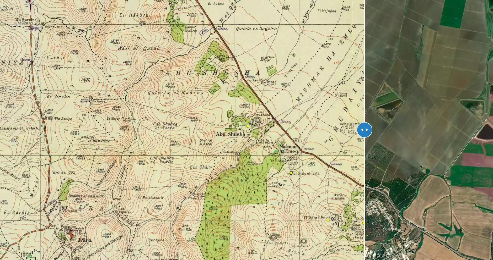
| Map Location | See location #30 on the map View from satellite |
||||||||||
| Military Operation | Battle for Mishmar Ha'emek | ||||||||||
| Attacking Units | Units drawn from the Palmach, as well as the Carmeli and Alexandroni Brigades | ||||||||||
| Defenders | Arab Liberation Army | ||||||||||
| Exodus Cause | Military assault by Zionist troops | ||||||||||
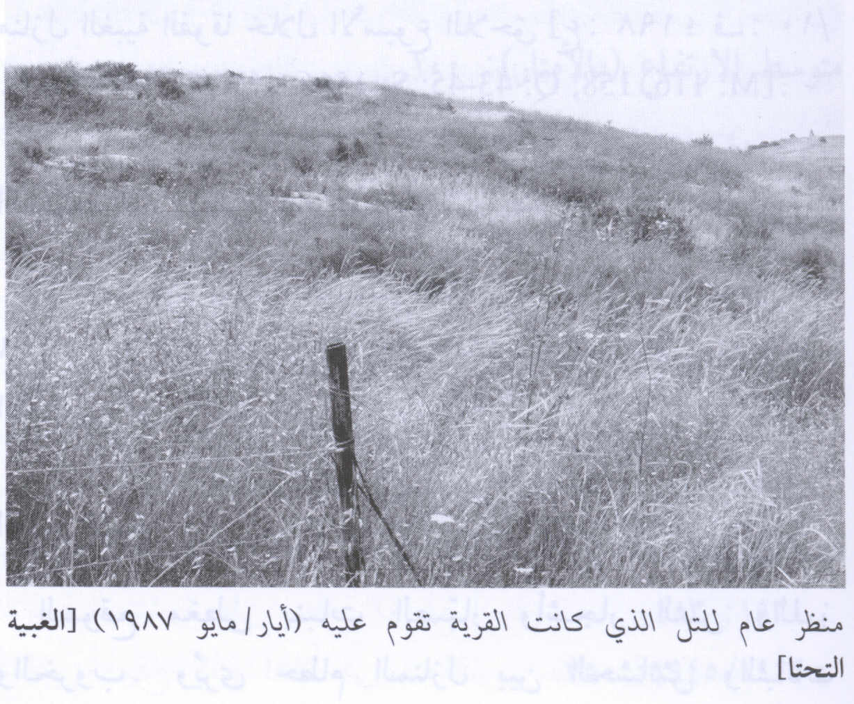
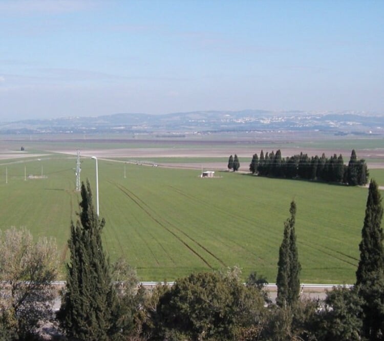
| Village Temains | The village has been completely obliterated in mid March 1948 | ||||||||||
| Ethnically Cleansing | al-Ghubayya al-Tahta inhabitants were completely ethnically cleansed. | ||||||||||
| Pre-Nakba Land Ownership |
**Town Lands' Demarcation Maps |
||||||||||
| Population |
|
||||||||||
| Number of Houses |
|
||||||||||
| Schools | al-Ghubayya al-Tahta shared an elementary school (founded by the Ottomans in 1888) with the villages of al-Ghubayya-al-Fawqa and al-Naghnaghiyya. The school was later on closed during the British Mandate period. | ||||||||||
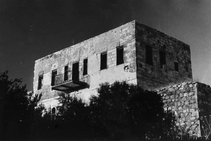
| Archeological Sites | The village had several khirbats (including Tel Abu Shusha) which contained artifacts such as fragments of pottery, pieces of masonry, and an olive press. | ||||||||||
| Exculsive Jewish Colonies Who Usurped Village Lands |
Midrakh 'Oz | ||||||||||
| Featured Video | |||||||||||
Village Before NakbaThe village was one of a group of three villages, known collectively as al-Ghubayyat, that were located on the eastern slopes of the bilad al-rawha' (the "fragrant country"; see Daliyat al-Rawha', Haifa sub-disctrict); the other two villages were al-Ghubayya al-Fawqa and al-Naghnaghiyya. It was located on a hill and overlooked the plain of Marj ibn Amir. The Haifa-Jenin highway ran close to it to the northeast. The second part of its name meant "lower" in Arabic, and served to distinguish it from its "upper" counterpart, al-Ghubayya al-Fawqa. It was also called al-Ghaba al-Tahta ("the lower forest"). AI-Ghubayya al-Tahta's population was Muslim. It was classified as a hamlet by the Palestine Index Gazetteer and had a rectangular layout. Its houses were made of cement and mud. It shared an elementary school with the other two villages that was built around 1888, during Ottoman rule; this school was closed down under the Mandate. The three villages had access to a number of water sources, including wadis, springs, and the al-Muqatta' River. Their economies were based on animal husbandry and agriculture, with grain being the chief crop. In 1944/45 a total of 10,883 dunums of the lands of the three villages was allocated to cereals, and 209 dunums were irrigated or used for orchards. A number of khirbas lay on their lands and contained artifacts such as fragments of pottery, pieces of masonry, and an olive press. The nearest large archaeological site was at Tall Abu Shusha.Village Occupation and Ethnic CleaningOn 15 March 1948, a New York Times correspondent wrote that the Haganah demolished fourteen houses and damaged ten others at al-Ghubayya al-Tahta, adding that '[there were no casualties, as the village had been evacuated after a Jewish attack on Friday]'. Nothing further is mentioned about that earlier attack, and it is unclear whether the villagers later returned. The correspondent commented on the Haganah demolition at al-Ghubayya al-Tahta by saying, 'In what appears to be a new strategy: concentration on the destruction of property..., the Haganah has in the last three days carried out five such 'punitive' operations.' The locations of the others were not given. Palestinian historian Arif al-Arif confirms this attack, writing that the village was completely destroyed in the early months of the war by Zionist forces from the nearby settlement of Mishmar ha-Emeq, which was at some points no more than 50 m away. But he adds that its residents escaped harm, having already sought refuge in its sister village of al-Ghubayya al-Fawqa.Some time after the two March attacks on the village, the Arab Liberation Army (ALA) launched in early April 1948 an attack on Mishmar ha-Emeq. ALA commander Fawzi al-Qawuqji reported that when British forces ordered the ALA to cease the attack on the kibbutz, they agreed, provided Jewish forces refrained from taking revenge on the surrounding villages. But the Haganah command refused the offer and ordered their units to occupy and destroy the surrounding villages of Marj ibn Amir. A 'pitched battle' was later fought around the two villages of al-Ghubayya al-Tahta and al-Ghubayya al-Fawqa, according to al-Qawuqji, during which they changed hands a few times before being captured by Zionist forces around the middle of April. The inhabitants of Kibbutz Mishmar ha-Emeq, nearby to the northwest of al-Ghubayya al-Tahta, attacked the village on 25 April 1948 and destroyed the houses that still stood after the Haganah attack on 15 March. The inhabitants at first fled to al-Ghubayya al-Fawqa. Zionists Colonies on Village LandsPart of the settlement of Midrakh Oz is on village land.Village TodayNo traces of houses can be identified; the Israeli settlement of Midrakh Oz, along with its playgrounds and race tracks, has completely occupied the site. Olive trees that grow there were most probably planted before the establishment of the settlement.SourceDr. Walid al-Khalidi, 1992: All That Remains. |
|||||||||||
| Related Maps | Town Lands' Demarcation Maps خرائط للقضاء توضح حدود القرى والاودية Town's map on MapQuest View from satellite Help us map this town at WikiMapia |
||||||||||
| Related Links | Wikipedia's Page Google Search Google For Images Google For Videos |
||||||||||
| More Information | في كتاب كي لا ننسى في كتاب بلادنا فلسطين في كتاب النكبة والفردوس المفقود المزيد من موقع هوية |
||||||||||
Want to browse more? 80,000 pictures were grouped in these gallaries:
| Display Name | Clan/Hamolah | Country of Residence |
| أحمد أبوزينة | أبوزينة | Palestine |
| محمد تركمان | تركمان | الزبابدة, فلسطين |
| Motasem Hassan | turkman | jordan |
| gassan deeb | nagnaggya | nablus, palestine |
| سامي | تركمان | - |
| Arab Al Turkman | Arab Al Turkman | - |
 Fake Valor: Why Did Zionist Jews Hoist Nazis Flag on Their Ships in the 1930s?
What is new?
-
Facts About Oct. 7th Gaza Raid
-
Remined Us Please:: Who Did Rape Who? Palestinians Raped Israelis? Or, was the other way around?
-
When Prof. Edward Said was invited to debate Bibi Netanyahu in the 1980s, watch what happened!
-
Ezra Klein of the NY Times on the "Jewish Race".
-
Abusing Blood Libel!
-
Zionist FAQ: Isn't it true that Palestinians don't want peace? Palestinians never accepted the two-state solution
- Facts about Haavara (Transfer) Agreement between Ben-Gurion & Hitler
-
Haavara FAQs: Why Did Zionist Jews Hoist Nazis' Flags on Their Ships in the 1930s?
-
Dear ChatGPT: Why did the Jewish Agency suppress news of the Holocaust during WWII?
-
Video Playlist: Jews share their DNA tests to end the conflict for good.
-
A Tale of Two Conflicts: Examining the Definition of Genocide
-
Prof. Abraham Polak And The Suppressed History of the Khazars and European Jewry
-
How Ronald Reagan would have framed the genocide in Gaza if he were still alive?
-
Haavara FAQs: Let us do the math: how many German Jews did The Haavara Agreement save?
-
Zionist FAQs: The Hebron Massacre of 1929, "clearly proves" that Palestinians are antisemitic, how could you deny it?
-
Zionist FAQs: Why Anti-Zionist Is Not Antisemitism?
-
Zionist FAQs: Isn't it true that the KGB create Palestinian Nationalism in the early 1960s?
- Zionist FAQs: Muslims are killing Muslims all the time; why are Israeli Jews being singled out in the media?
- Zionist FAQs: How is Israel an apartheid state when 20% of its citizens are Arabs who enjoy full rights?
-
Haavara FAQs: Analysis of Herzl's Uganda Scheme and how it could have saved millions of Jews.
-
Haavara FAQs: Why did Hayim Greenberg describe American Jewry as "morally bankrupt" in early 1943?
-
Haavara FAQs: What if the Evian Conference was a resounding success? What would have been the impact of saving European Jewry on Zionism?
- Haavara FAQs: What if the six million were saved, how that would have impacted the Zionist project?
-
Haavara FAQs: How did Zionist leaders react when Europe's Jews lingered in the DP camps after WWII ended?
-
Why does the American Jewish community repeat lies that David Ben-Gurion had debunked before he died?
-
Who has the power to rename the Tatar/Khazar Gene Marker to Jewish IV?
-
Zionist FAQs: Why won't Egypt, Syria, and Jordan take their people back? Jews are indigenous to Palestine, and Arabs immigrated after Jews developed the country. Arabs should leave.
-
Haavara FAQs: Did Hitler and the Nazis conflate between Judaism and Zionist? If that wasn't case, then why?
-
Haavara FAQs: Winston Churchill and antisemitism, a collection of articles written Churchill.
-
Haavara FAQs: Broken by country, how many Jews survived vs. killed during the Holocaust?
-
Haavara FAQs: Why did European Jews vote with their feet and to immigrated to the Americas, not Palestine, after WWII?
-
Watch this American Jewish Girl describing Israeli Jews' cognitive dissonance like no other in under two minutes
-
Haavara FAQs: When the Nazis went out of their way to hide the Holocaust, Israeli Jews did the exact opposite by broadcasting their genocide of Gazans. But why?
-
Haavara FAQs: How Zionist Jews went out of their to show their appreciation to Nazism and Fascism?
- Haavara FAQs: Why Zionist leaders were against bombing the death camps & the Railroads leading to them?
-
Haavara FAQs: Hitler's message to the British and American people: If Jews are such noble citizens and you care about them, how come you're not letting them in? I will gladly ship them to you at my expense, even on luxury liners!
-
A shortlist of Zionist and Israeli false flag operations in the name Jews.
-
The Most Moral Army
- The Land of Kapos (Israel): Where the brave are boycotted and Kapos walk free.
- Why did early Zionists often named their communal enterprises "colonial"?
- Zionist Relations with Nazi Germany by Faris Glubb
-
Two NY Times advertisements by Zionists in the early 1943 that exposes Zionists' treason at the height of the calamity
- Facts Not Lies about the Palestinian-Israeli Conflict.
- Site's pictures have been categorized
- Campgain Against Lice
- A Survey of Palestine, the official source about Palestine before Nakba produced by the British Mandate; over 1200 pages.
- Satellite View & Google Earth: Over 6,000 placemarks identifying all destroyed towns, W. Bank & Gaza Strip Towns, & refugee camps.
- PalestineRemembered.com and its Nakba Oral History Project were featured on al-Jazeera Satellite TV.
- Nakba Oral History Video Podcast:
 Over 700 Oral History interviews (including 3,500+ hours of recording) can be viewed online.
 - Palestine Village Statistics Project
- Gaza Jail Break
- النسخة العربية للموقع الان متوفرة
- Videos: Documenting the destroyed villages in video: Tracing all that remains since Nakba.
- Videos: Responding to Zionist Propaganda
- Interview: The ethnic cleansing of Palestine: George Galloway interviews Israeli Historian Ilan Pappe.
- For Palestinians, memory matters. It provides a blueprint for their future By George Bisharat.
- Zionist FAQ now available in Hebrew שאלות שציונים שואלים, עכשיו בעברית
- Video: The Stephen Walt and John Mearsheimer report on the influence of the Israel Lobby on U.S. Foreign Policy
- The Palestinian-Israeli conflict for beginners
