| PalestineRemembered | About Us | Oral History | العربية | |
| Pictures | Zionist FAQs | Haavara | Maps | |
| Search |
| Camps |
| Districts |
| Acre |
| Baysan |
| Beersheba |
| Bethlehem |
| Gaza |
| Haifa |
| Hebron |
| Jaffa |
| Jericho |
| Jerusalem |
| Jinin |
| Nablus |
| Nazareth |
| Ramallah |
| al-Ramla |
| Safad |
| Tiberias |
| Tulkarm |
| Donate |
| Contact |
| Profile |
| Videos |
Welcome To al-Muntar, Khirbat - خربة المنظار (ח'ירבת אל-מנטאר)
|
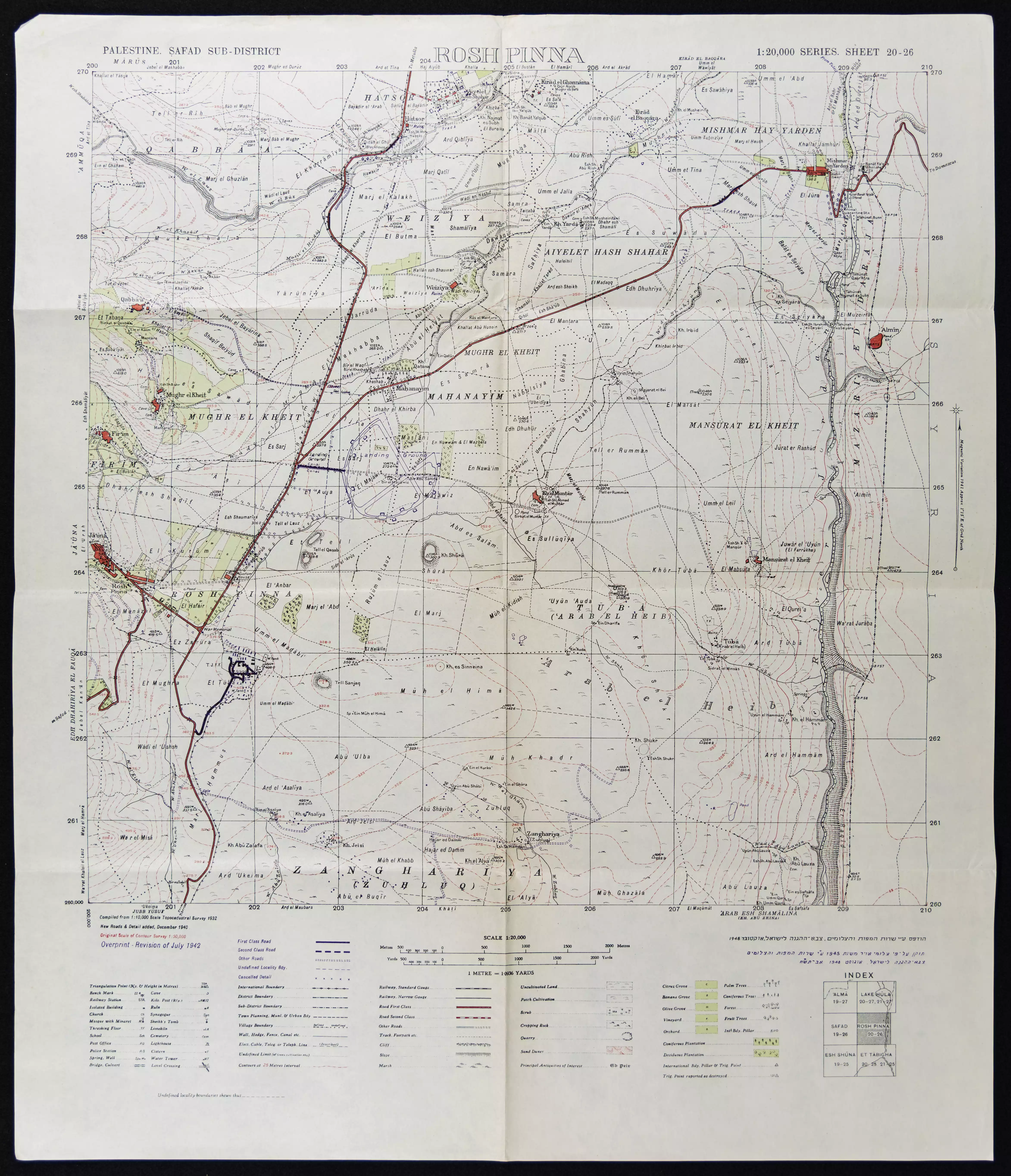
District of Safad
Ethnically cleansed days ago |
العربية Google Earth |
 |
Gallery (1) |
- Statistics & Facts
-
Before & After

- Satellite View
- Articles 1
- Pictures 1
- Members
- All That Remains
- Wikipedia
- Videos
- Guest Book
- Links
| Statistic & Fact | Value | ||||||||||
| Occupation Date | July 20, 1949 | ||||||||||
| Distance From District | 8.5 (km) East of Safad | ||||||||||
| Elevation | 250 (meters) | ||||||||||
| Before & After Nakba, Click Map For Details |
|||||||||||
|
|||||||||||
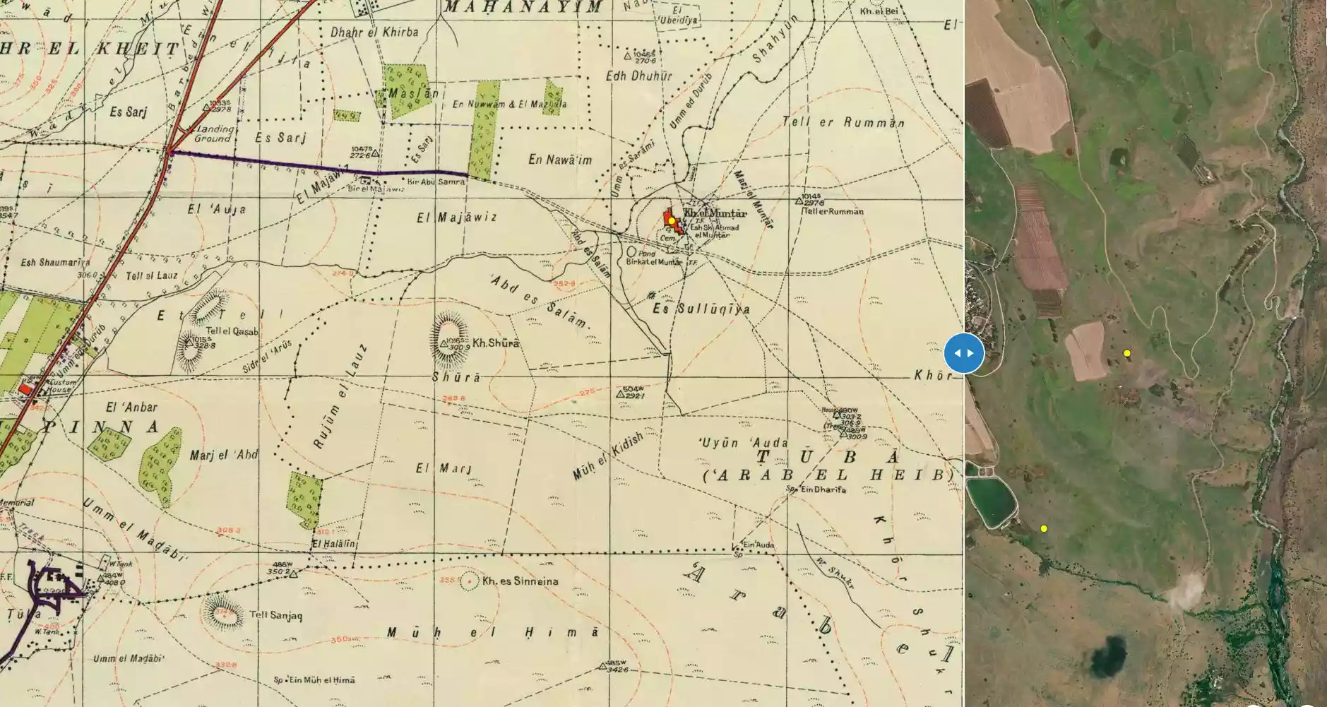
| Map Location | See location #64 on the map View from satellite |
||||||||||
| Military Operation | Operation Yiftach (commanded by the ethnic cleansing champion Yigal Allon) | ||||||||||
| Attacking Units | The Palmach's First Battalion and 'Oded Brigade | ||||||||||
| Defenders | Syrian Army | ||||||||||
| Exodus Cause | Expulsion by Zionist troops | ||||||||||
| Village Temains | The village has been completely destroyed | ||||||||||
| Ethnically Cleansing | The village has been completely ethnically cleansed by between 1949-1956. | ||||||||||
| Pre-Nakba Land Ownership |
|
||||||||||
| Inhabitants Place of Origin | In 19th century, Turkish and Kurdish nomads were encamped in the village. | ||||||||||
| Nearby Wadies & Rivers | The village was nearby Wadi Shahyan. | ||||||||||
| Exculsive Jewish Colonies Who Usurped Village Lands |
Machanayim is nearby village lands | ||||||||||
Village Before NakbaThe village was situated in a volcanic region that sloped gradually toward the al-Hula Plain to the north and that was drained by Wadi Shahyan. In 1840 the American traveler and biblical scholar Edward Robinson noted that al-Muntar was an encampment of Turkish and Kurdish nomads. He also saw settlements of Arab Bedouin there. Much of the land near Khirbat al-Muntar was purchased around the turn of the century by the Baron de Rothschild. The settlement of Machanayim (204266) was founded on this land in 1898, but it was not economically viable and was abandoned. This meant that the Arabs of Khirbat al-Muntar continued to work the land, even though they did not hold title to it, until at least 1939, when the settlement was reestablished. At that time Khirbat al-Muntar was a small village that the Mandate Palestine Index Gazetteer classified as a hamlet.Village Occupation and Ethnic CleaningThe first attacks on Khirbat al-Muntar may have taken place during Operation Yiftach, when the Yiftach Brigade invaded eastern Galilee (see Abil al-Qamh, Safad sub-disctrict). The brigade's orders were 'to destroy all bridges along roads approaching Palestine from Lebanon and from Syria ... ' and concentrate its forces 'in the Rosh Pinah-Ayelet Hashahar area .... ' Khirbat al-Muntar lay between Rosh Pinah and the bridge of Banat Ya'qub, on the Jordan.After attacking Syrian positions along the Jordan River, the Yiftach Brigade was withdrawn, in early June 1948. Syrian troops crossed 'the river on 10 June and captured the settlement of Mishmar ha-Yarden. On the following day the Syrians advanced westwards into 'the positions around Machanayim,' that is, close to Khirbat al-Muntar, but were stopped by units of the 'Oded Brigade. The front between the Syrian and Israeli troops, which must have been very close to Khirbat al-Muntar, remained stable throughout the first truce, which in this area took effect on 11 June and lasted until 9 July 1948. After this the 'Oded and Carmeli brigades made renewed efforts to push east to Mishmar ha-Yarden but failed. . Like the village of Yarda (205268), only 8 km to the north, Khirbat al-Muntar later fell on the periphery of the Demilitarized Zone (DMZ) between Syria and Israel after the July 1949 Armistice Agreement. This agreement was actually signed near the site of Khirbat al-Muntar, in a tent close to the Israeli settlement of Machanayim, on 20 July 1949. If Khirbat al-Muntar remained inhabited at that point, it is likely that the villagers suffered the same fate as those in villages that fell squarely within the DMZ. Israeli historian Benny Morris relates that the latter were driven out by the Israeli authorities between 1949 and 1956, by means of direct and indirect pressures (see Kirad al-Baqqara, Safad sub-district). Zionists Colonies on Village LandsThere are no Israeli settlements on village land. Machanayim (204266), re-established in 1939 after a series of failed settlement attempts, is about 1 km northwest of the site.Village TodayThe site is covered with stone rubble, grass, thorns, and a few cypress trees. There is a cow shed near the site. The cemetery is now used by the Bedouin of the nearby village of Tuba. Some of the surrounding land is used for grazing.SourceDr. Walid al-Khalidi, 1992: All That Remains. |
|||||||||||
| Related Maps | Town Lands' Demarcation Maps خرائط للقضاء توضح حدود القرى والاودية Town's map on MapQuest View from satellite Help us map this town at WikiMapia |
||||||||||
| Related Links | Wikipedia's Page Google Search Google For Images Google For Videos |
||||||||||
| More Information | في كتاب كي لا ننسى المزيد من موقع هوية |
||||||||||
Want to browse more? 80,000 pictures were grouped in these gallaries:
| Display Name | Clan/Hamolah | Country of Residence |
No links have been shared yet, be free to the first to share the first link.
 Fake Valor: Why Did Zionist Jews Hoist Nazis Flag on Their Ships in the 1930s?
What is new?
-
Facts About Oct. 7th Gaza Raid
-
Remined Us Please:: Who Did Rape Who? Palestinians Raped Israelis? Or, was the other way around?
-
When Prof. Edward Said was invited to debate Bibi Netanyahu in the 1980s, watch what happened!
-
Ezra Klein of the NY Times on the "Jewish Race".
-
Abusing Blood Libel!
-
Did Israeli Soldiers Activate The Hanniba Direective On Oct. 7th? You Be The Judge
-
Zionist FAQ: Isn't it true that Palestinians don't want peace? Palestinians never accepted the two-state solution
- Facts about Haavara (Transfer) Agreement between Ben-Gurion & Hitler
-
Haavara FAQs: Why Did Zionist Jews Hoist Nazis' Flags on Their Ships in the 1930s?
- Haavara FAQs: When Chaim Weizmann met FDR in mid-1943, why was he silent about rescuing European Jewry?
-
Dear ChatGPT: How did Palestinians resist Napoleon's invasion of their country in 1799?
-
Dear ChatGPT: Gaza had a vibrant Jewish community in the mid-17th century. What happened to them?
-
Dear ChatGPT: Why did the Jewish Agency suppress news of the Holocaust during WWII?
-
Video Playlist: Jews share their DNA tests to end the conflict for good.
-
A Tale of Two Conflicts: Examining the Definition of Genocide
-
Prof. Abraham Polak And The Suppressed History of the Khazars and European Jewry
-
How Ronald Reagan would have framed the genocide in Gaza if he were still alive?
-
Haavara FAQs: Let us do the math: how many German Jews did The Haavara Agreement save?
-
Zionist FAQs: The Hebron Massacre of 1929, "clearly proves" that Palestinians are antisemitic, how could you deny it?
-
Zionist FAQs: Why Anti-Zionist Is Not Antisemitism?
-
Zionist FAQs: Isn't it true that the KGB created Palestinian Nationalism in the early 1960s?
- Zionist FAQs: Muslims are killing Muslims all the time; why are Israeli Jews being singled out in the media?
- Zionist FAQs: How is Israel an apartheid state when 20% of its citizens are Arabs who enjoy full rights?
-
Haavara FAQs: Why Did Dorothy Thompson Flip From A Zionist Advocate to A Silenced Dissenter?
-
Haavara FAQs: Analysis of Herzl's Uganda Scheme and how it could have saved millions of Jews.
-
Haavara FAQs: Why did Hayim Greenberg describe American Jewry as "morally bankrupt" in early 1943?
-
Haavara FAQs: What if the Evian Conference was a resounding success? What would have been the impact of saving European Jewry on Zionism?
- Haavara FAQs: What if the six million were saved, how that would have impacted the Zionist project?
-
Haavara FAQs: How did Zionist leaders react when Europe's Jews lingered in the DP camps after WWII ended?
-
Why does the American Jewish community repeat lies that David Ben-Gurion had debunked before he died?
-
Who has the power to rename the Tatar/Khazar Gene Marker to Jewish IV?
-
Zionist FAQs: Why won't Egypt, Syria, and Jordan take their people back? Jews are indigenous to Palestine, and Arabs immigrated after Jews developed the country. Arabs should leave.
-
Haavara FAQs: Did Hitler and the Nazis conflate between Judaism and Zionist? If that wasn't case, then why?
-
Haavara FAQs: Winston Churchill and antisemitism, a collection of articles written Churchill.
-
Haavara FAQs: Broken by country, how many Jews survived vs. killed during the Holocaust?
-
Haavara FAQs: Why did European Jews vote with their feet and to immigrated to the Americas, not Palestine, after WWII?
-
Watch this American Jewish Girl describing Israeli Jews' cognitive dissonance like no other in under two minutes
-
Haavara FAQs: When the Nazis went out of their way to hide the Holocaust, Israeli Jews did the exact opposite by broadcasting their genocide of Gazans. But why?
-
Haavara FAQs: How Zionist Jews went out of their to show their appreciation to Nazism and Fascism?
- Haavara FAQs: Why Zionist leaders were against bombing the death camps & the Railroads leading to them?
-
Haavara FAQs: Hitler's message to the British and American people: If Jews are such noble citizens and you care about them, how come you're not letting them in? I will gladly ship them to you at my expense, even on luxury liners!
-
A shortlist of Zionist and Israeli false flag operations in the name Jews.
-
The Most Moral Army
- The Land of Kapos (Israel): Where the brave are boycotted and Kapos walk free.
- Why did early Zionists often named their communal enterprises "colonial"?
- Zionist Relations with Nazi Germany by Faris Glubb
-
Two NY Times advertisements by Zionists in the early 1943 that exposes Zionists' treason at the height of the calamity
- Facts Not Lies about the Palestinian-Israeli Conflict.
- Site's pictures have been categorized
- Campgain Against Lice
- A Survey of Palestine, the official source about Palestine before Nakba produced by the British Mandate; over 1200 pages.
- Satellite View & Google Earth: Over 6,000 placemarks identifying all destroyed towns, W. Bank & Gaza Strip Towns, & refugee camps.
- PalestineRemembered.com and its Nakba Oral History Project were featured on al-Jazeera Satellite TV.
- Nakba Oral History Video Podcast:
 Over 700 Oral History interviews (including 3,500+ hours of recording) can be viewed online.
 - Palestine Village Statistics Project
- Gaza Jail Break
- النسخة العربية للموقع الان متوفرة
- Videos: Documenting the destroyed villages in video: Tracing all that remains since Nakba.
- Videos: Responding to Zionist Propaganda
- Interview: The ethnic cleansing of Palestine: George Galloway interviews Israeli Historian Ilan Pappe.
- For Palestinians, memory matters. It provides a blueprint for their future By George Bisharat.
- Zionist FAQ now available in Hebrew שאלות שציונים שואלים, עכשיו בעברית
- Video: The Stephen Walt and John Mearsheimer report on the influence of the Israel Lobby on U.S. Foreign Policy
- The Palestinian-Israeli conflict for beginners
