| PalestineRemembered | About Us | Oral History | العربية | |
| Pictures | Zionist FAQs | Haavara | Maps | |
| Search |
| Camps |
| Districts |
| Acre |
| Baysan |
| Beersheba |
| Bethlehem |
| Gaza |
| Haifa |
| Hebron |
| Jaffa |
| Jericho |
| Jerusalem |
| Jinin |
| Nablus |
| Nazareth |
| Ramallah |
| al-Ramla |
| Safad |
| Tiberias |
| Tulkarm |
| Donate |
| Contact |
| Profile |
| Videos |
Welcome To Nimrin - نمرين (נימרין)
|
District of Tiberias
Ethnically cleansed days ago |
العربية Google Earth |
 |
Gallery (3) |
- Statistics & Facts
-
Before & After

- Satellite View
- Articles 2
- Pictures 3
- Oral History 5
- Members 10
- All That Remains
- Wikipedia
- Videos 1
- Guest Book 11
- Links
| Statistic & Fact | Value | |||||||||||||||||||||
| Occupation Date | July 16, 1948 | |||||||||||||||||||||
| Distance From District | 10.5 (km) Northwest of Tiberias | |||||||||||||||||||||
| Elevation | 350 (meters) | |||||||||||||||||||||
| Before & After Nakba, Click Map For Details |
||||||||||||||||||||||
|
||||||||||||||||||||||
| Map Location | See location #10 on the map View from satellite |
|||||||||||||||||||||
| Military Operation | Operation Dekel | |||||||||||||||||||||
| Exodus Cause | Military assault by Zionist troops | |||||||||||||||||||||
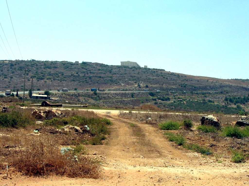
| Village Temains | Nimrin was completely obliterated and defaced. | |||||||||||||||||||||
| Ethnically Cleansing | Nimrin inhabitants were completely ethnically cleansed. | |||||||||||||||||||||
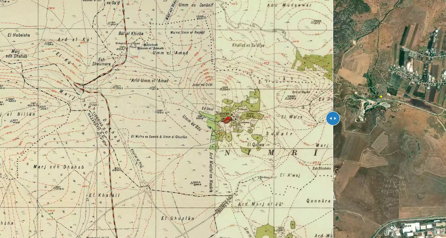
| Pre-Nakba Land Ownership |
**Town Lands' Demarcation Maps |
|||||||||||||||||||||
| Land Usage As of 1945 |
|
|||||||||||||||||||||
| Population |
|
|||||||||||||||||||||
| Number of Houses |
|
|||||||||||||||||||||
| Near By Towns |
||||||||||||||||||||||
|
||||||||||||||||||||||
| Schools | Nimrin an elementary school for boys which was founded by Ottoman, but it was closed during the British Mandate period. | |||||||||||||||||||||
| Exculsive Jewish Colonies Who Usurped Village Lands |
Achuzzat Naftali | |||||||||||||||||||||
| Featured Video | ||||||||||||||||||||||
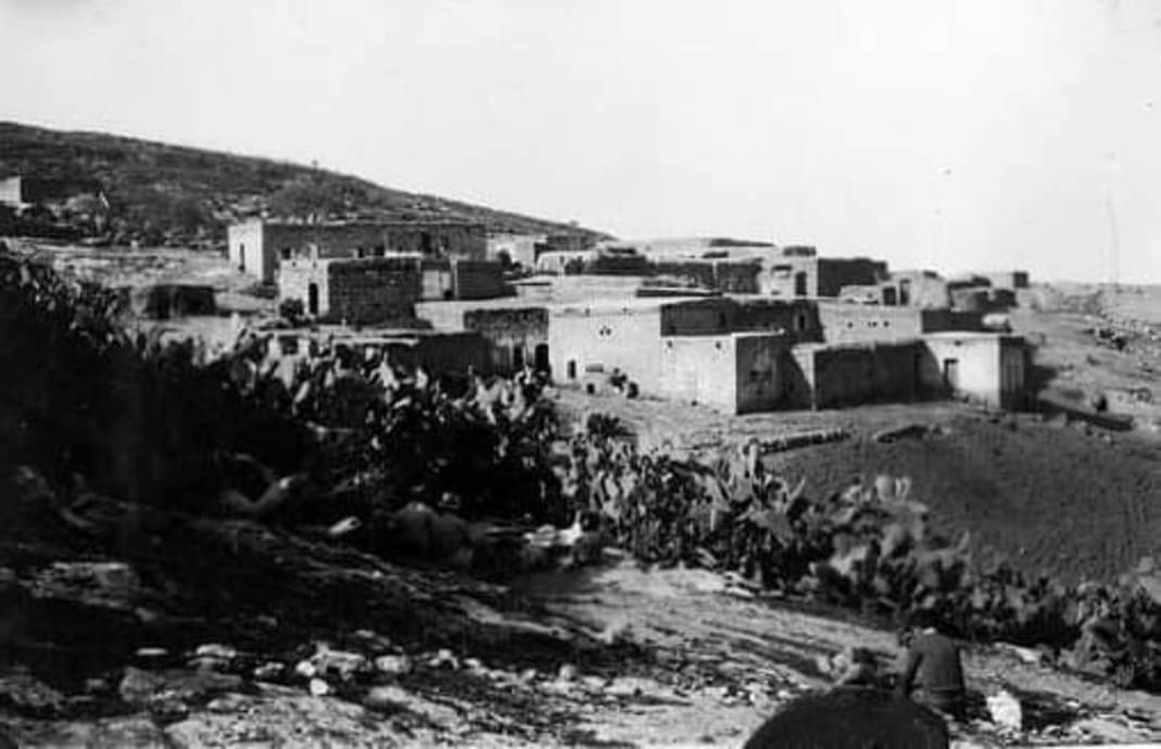
Village Before NakbaThe village was located on the saddle between two hills to the northwest and southeast. It faced the Tur'an Plain to the southwest. Mount Tabor (Jabal al-Tur) could be seen in the distance, to the south. In Roman times it was a settlement of priests known as Kefar Nimra. In 1596, Nimrin was a village in the nahiya of Tiberias (liwa' of Safad) with a population of 110. It paid taxes on a number of crops, including wheat, barley, and olives, as well as on other types of property, such as goats and beehives. [Hut. and Abd.:189]Nimrin was described in the late nineteenth century as a stone-built village on the slope of a hill, with a population of about 250. [SWP (1881) I:361] The village had a small oval core in which houses were densely clustered. New houses were scattered to the northeast of this core. The houses were built of stone, cement, mud, or concrete; their roofs were made of wood or reeds and covered with a layer of mud. The entire population was Muslim. An elementary school for boys was founded in Nimrin in the Ottoman period but was closed during the British Mandate. The villagers drew their drinking water from a well that was 1.5 km to the south and from cisterns that collected rainwater. The main economic pursuits were agriculture and livestock; grain was the most important crop, and vegetables were planted in small areas. In 1944/45 a total of 7,905 dunums was allotted to cereals and 335 dunums were irrigated or devoted to orchards, 300 dunums of which were for fruit-bearing olive trees. The village had one manual olive press. Nimrin was built over the remains of the Roman site; evidence of this could be seen in the rock-cut presses, tombs, and the remains of cisterns. Village Occupation and Ethnic CleaningThe fate of Nimrin was probably the same as that of Lubya and Hittin, villages in the vicinity that fell at the end of Operation Dekel (see 'Amqa, Acre sub-disctrict). Israeli historian Benny Morris indicates that the village fell on 16-17 July 1948, towards the end of the Ten Days that separated the two truces of the war. Morris does not describe the exact circumstances of its occupation and it is not clear what made the villagers leave.Zionists Colonies on Village LandsThe settlement of Achuzzat Naftali (194244) was built on village land in 1949.The site and a major part of the lands are surrounded by a fence.Village TodayThe site and a major part of the lands are surrounded by a fence.SourceDr. Walid al-Khalidi, 1992: All That Remains. |
||||||||||||||||||||||
| Related Maps | Town Lands' Demarcation Maps خرائط للقضاء توضح حدود القرى والاودية Town's map on MapQuest View from satellite Help us map this town at WikiMapia |
|||||||||||||||||||||
| Related Links | Wikipedia's Page Google Search Google For Images Google For Videos |
|||||||||||||||||||||
| More Information | في كتاب كي لا ننسى في كتاب بلادنا فلسطين المزيد من موقع هوية |
|||||||||||||||||||||
Want to browse more? 80,000 pictures were grouped in these gallaries:
| Display Name | Clan/Hamolah | Country of Residence |
| khaled ibrahim | نمرين | نمرين, نمرين |
| khaled alnmir | فلسطين | فلسطين, نمرين |
| العاصفة الحمراء | - | - |
| ابو علي | النمارنة | مخيم اليرموك, مخيم اليرموك |
| adham ebrahem | نمارنة | سوريا وقريبا انشاء الله بفلسطين |
| الجهادي | النمريني | سورية, سورية |
| سامي | - | - |
| احمد عليّان | - | - |
| ابو خالد | النمارنه | ابوظبي, الامارات |
| Nemer Khaled | - | - |
- الذاكرة مفتاح العودة-الحلقة 49- قرية نمرين Duration: 23 min 22 sec
No links have been shared yet, be free to the first to share the first link.
 Fake Valor: Why Did Zionist Jews Hoist Nazis Flag on Their Ships in the 1930s?
What is new?
-
Facts About Oct. 7th Gaza Raid
-
Remined Us Please:: Who Did Rape Who? Palestinians Raped Israelis? Or, was the other way around?
-
When Prof. Edward Said was invited to debate Bibi Netanyahu in the 1980s, watch what happened!
-
Ezra Klein of the NY Times on the "Jewish Race".
-
Abusing Blood Libel!
-
Zionist FAQ: Isn't it true that Palestinians don't want peace? Palestinians never accepted the two-state solution
- Facts about Haavara (Transfer) Agreement between Ben-Gurion & Hitler
-
Haavara FAQs: Why Did Zionist Jews Hoist Nazis' Flags on Their Ships in the 1930s?
- Haavara FAQs: When Chaim Weizmann met FDR in mid-1943, why was he silent about rescuing European Jewry?
-
Dear ChatGPT: How did Palestinians resist Napoleon's invasion of their country in 1799?
-
Dear ChatGPT: Gaza had a vibrant Jewish community in the mid-17th century. What happened to them?
-
Dear ChatGPT: Why did the Jewish Agency suppress news of the Holocaust during WWII?
-
Video Playlist: Jews share their DNA tests to end the conflict for good.
-
A Tale of Two Conflicts: Examining the Definition of Genocide
-
Prof. Abraham Polak And The Suppressed History of the Khazars and European Jewry
-
How Ronald Reagan would have framed the genocide in Gaza if he were still alive?
-
Haavara FAQs: Let us do the math: how many German Jews did The Haavara Agreement save?
-
Zionist FAQs: The Hebron Massacre of 1929, "clearly proves" that Palestinians are antisemitic, how could you deny it?
-
Zionist FAQs: Why Anti-Zionist Is Not Antisemitism?
-
Zionist FAQs: Isn't it true that the KGB create Palestinian Nationalism in the early 1960s?
- Zionist FAQs: Muslims are killing Muslims all the time; why are Israeli Jews being singled out in the media?
- Zionist FAQs: How is Israel an apartheid state when 20% of its citizens are Arabs who enjoy full rights?
-
Haavara FAQs: Analysis of Herzl's Uganda Scheme and how it could have saved millions of Jews.
-
Haavara FAQs: Why did Hayim Greenberg describe American Jewry as "morally bankrupt" in early 1943?
-
Haavara FAQs: What if the Evian Conference was a resounding success? What would have been the impact of saving European Jewry on Zionism?
- Haavara FAQs: What if the six million were saved, how that would have impacted the Zionist project?
-
Haavara FAQs: How did Zionist leaders react when Europe's Jews lingered in the DP camps after WWII ended?
-
Why does the American Jewish community repeat lies that David Ben-Gurion had debunked before he died?
-
Who has the power to rename the Tatar/Khazar Gene Marker to Jewish IV?
-
Zionist FAQs: Why won't Egypt, Syria, and Jordan take their people back? Jews are indigenous to Palestine, and Arabs immigrated after Jews developed the country. Arabs should leave.
-
Haavara FAQs: Did Hitler and the Nazis conflate between Judaism and Zionist? If that wasn't case, then why?
-
Haavara FAQs: Winston Churchill and antisemitism, a collection of articles written Churchill.
-
Haavara FAQs: Broken by country, how many Jews survived vs. killed during the Holocaust?
-
Haavara FAQs: Why did European Jews vote with their feet and to immigrated to the Americas, not Palestine, after WWII?
-
Watch this American Jewish Girl describing Israeli Jews' cognitive dissonance like no other in under two minutes
-
Haavara FAQs: When the Nazis went out of their way to hide the Holocaust, Israeli Jews did the exact opposite by broadcasting their genocide of Gazans. But why?
-
Haavara FAQs: How Zionist Jews went out of their to show their appreciation to Nazism and Fascism?
- Haavara FAQs: Why Zionist leaders were against bombing the death camps & the Railroads leading to them?
-
Haavara FAQs: Hitler's message to the British and American people: If Jews are such noble citizens and you care about them, how come you're not letting them in? I will gladly ship them to you at my expense, even on luxury liners!
-
A shortlist of Zionist and Israeli false flag operations in the name Jews.
-
The Most Moral Army
- The Land of Kapos (Israel): Where the brave are boycotted and Kapos walk free.
- Why did early Zionists often named their communal enterprises "colonial"?
- Zionist Relations with Nazi Germany by Faris Glubb
-
Two NY Times advertisements by Zionists in the early 1943 that exposes Zionists' treason at the height of the calamity
- Facts Not Lies about the Palestinian-Israeli Conflict.
- Site's pictures have been categorized
- Campgain Against Lice
- A Survey of Palestine, the official source about Palestine before Nakba produced by the British Mandate; over 1200 pages.
- Satellite View & Google Earth: Over 6,000 placemarks identifying all destroyed towns, W. Bank & Gaza Strip Towns, & refugee camps.
- PalestineRemembered.com and its Nakba Oral History Project were featured on al-Jazeera Satellite TV.
- Nakba Oral History Video Podcast:
 Over 700 Oral History interviews (including 3,500+ hours of recording) can be viewed online.
 - Palestine Village Statistics Project
- Gaza Jail Break
- النسخة العربية للموقع الان متوفرة
- Videos: Documenting the destroyed villages in video: Tracing all that remains since Nakba.
- Videos: Responding to Zionist Propaganda
- Interview: The ethnic cleansing of Palestine: George Galloway interviews Israeli Historian Ilan Pappe.
- For Palestinians, memory matters. It provides a blueprint for their future By George Bisharat.
- Zionist FAQ now available in Hebrew שאלות שציונים שואלים, עכשיו בעברית
- Video: The Stephen Walt and John Mearsheimer report on the influence of the Israel Lobby on U.S. Foreign Policy
- The Palestinian-Israeli conflict for beginners
