| PalestineRemembered | About Us | Oral History | العربية | |
| Pictures | Zionist FAQs | Haavara | Maps | |
| Search |
| Camps |
| Districts |
| Acre |
| Baysan |
| Beersheba |
| Bethlehem |
| Gaza |
| Haifa |
| Hebron |
| Jaffa |
| Jericho |
| Jerusalem |
| Jinin |
| Nablus |
| Nazareth |
| Ramallah |
| al-Ramla |
| Safad |
| Tiberias |
| Tulkarm |
| Donate |
| Contact |
| Profile |
| Videos |
Welcome To al-'Ubaydiyya - العبيدية (אל-עובידיה)
|
District of Tiberias
Ethnically cleansed days ago |
العربية Google Earth |
| Gallery (8) |
- Statistics & Facts
-
Before & After

- Satellite View
- Articles 1
- Pictures 8
- Oral History 2
- Members 2
- All That Remains
- Wikipedia
- Videos
- Guest Book 8
- Links
| Statistic & Fact | Value | ||||||||||||||||||||||||
| Occupation Date | March 3, 1948 | ||||||||||||||||||||||||
| Distance From District | 11 (km) South of Tiberias | ||||||||||||||||||||||||
| Elevation | -225 (meters) | ||||||||||||||||||||||||
| Before & After Nakba, Click Map For Details |
|||||||||||||||||||||||||

|
|||||||||||||||||||||||||
| Map Location | See location #20 on the map View from satellite |
||||||||||||||||||||||||
| Exodus Cause | Fear of Jewish attack, or of being caught in the fighting | ||||||||||||||||||||||||
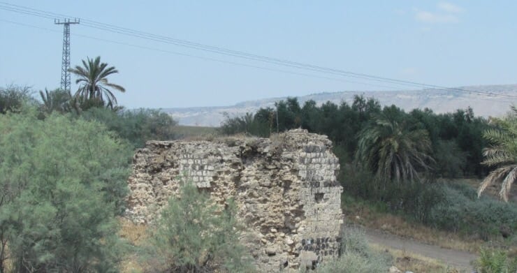
| Village Temains | al-'Ubaydiyya was completely destroyed, and only house rubble and the watermill left behind. | ||||||||||||||||||||||||
| Ethnically Cleansing | On March 3rd 1948, the inhabitants of al-'Ubaydiyya were intimidated into fleeing their homes and farms by the Haganah to Nazareth. | ||||||||||||||||||||||||
| Pre-Nakba Land Ownership |
**Town Lands' Demarcation Maps |
||||||||||||||||||||||||
| Land Usage As of 1945 |
|
||||||||||||||||||||||||
| Population |
|
||||||||||||||||||||||||
| Number of Houses |
|
||||||||||||||||||||||||
| Near By Towns |
|||||||||||||||||||||||||
|
|||||||||||||||||||||||||
| Town's Name Through History | The Canaanites referred to al-'Ubaydiyya by Bayt Shamash. | ||||||||||||||||||||||||
| Schools | al-'Ubaydiyya had an elementary school for boys which was founded by the Ottomans. | ||||||||||||||||||||||||
| Nearby Wadies & Rivers | al-'Ubaydiyya is situated close to the Jordan River. | ||||||||||||||||||||||||
| Water Supply | al-'Ubaydiyya had a water-driven mill, the water for which was brought in by an elevated canal. | ||||||||||||||||||||||||
| Exculsive Jewish Colonies Who Usurped Village Lands |
Beyt Zera' is nearby village lands. | ||||||||||||||||||||||||
| Featured Video | |||||||||||||||||||||||||
Village TodayAccording to the Palestinian historian Walid Khalid, all that remains of the village:-The remaining section of the walls of the canal (that provided the mill with water) is the most prominent indication of the former existence of the village. Ruins of houses, piles of stones, the bases of walls, terraces, and date palms can be seen on the site |
|||||||||||||||||||||||||
| Related Maps | Town Lands' Demarcation Maps خرائط للقضاء توضح حدود القرى والاودية Town's map on MapQuest View from satellite Help us map this town at WikiMapia |
||||||||||||||||||||||||
| Related Links | Wikipedia's Page Google Search Google For Images Google For Videos |
||||||||||||||||||||||||
| More Information | في كتاب كي لا ننسى في كتاب بلادنا فلسطين المزيد من موقع هوية |
||||||||||||||||||||||||
- General view of the village site looking northwest, 1987
Scanned from "All That Remains" by Dr. Walid Khalidi - General view of the village land looking at the Jordan River, 1987
Scanned from "All That Remains" by Dr. Walid Khalidi 3 - The remains of a wall supporting the water channel of the village water mill, 1987
Scanned from "All That Remains" by Dr. Walid Khalidi - A view of the Jordan river from al-'Ubaydiyya's site
- ما تبقى من القريه
Posted by abu raya - العبيديه
Posted by abu raya - صورة نادرة لقرية العبيدية
Posted by احمد فحماوي 1 - منظر عام لقرية العبيدة المهجرة قبل النكبة 1920
Want to browse more? 80,000 pictures were grouped in these gallaries:
| Display Name | Clan/Hamolah | Country of Residence |
| محمود داوود | - | - |
| لطفي الداوود | الداوود | Riyadh, Saudi Arabia |
No links have been shared yet, be free to the first to share the first link.


