| PalestineRemembered | About Us | Oral History | العربية | |
| Pictures | Zionist FAQs | Haavara | Maps | |
| Search |
| Camps |
| Districts |
| Acre |
| Baysan |
| Beersheba |
| Bethlehem |
| Gaza |
| Haifa |
| Hebron |
| Jaffa |
| Jericho |
| Jerusalem |
| Jinin |
| Nablus |
| Nazareth |
| Ramallah |
| al-Ramla |
| Safad |
| Tiberias |
| Tulkarm |
| Donate |
| Contact |
| Profile |
| Videos |
Welcome To al-Dalhamiyya - الدلهمية (א-דלהמיה)
|
District of Tiberias
Ethnically cleansed days ago |
العربية Google Earth |
 |
Gallery (8) |
- Statistics & Facts
-
Before & After

- Satellite View
- Articles 1
- Pictures 8
- Oral History 1
- Members
- All That Remains
- Wikipedia
- Videos
- Guest Book
- Links
| Statistic & Fact | Value | |||||||||||||||
| Occupation Date | April 15, 1948 | |||||||||||||||
| Distance From District | 14 (km) South of Tiberias | |||||||||||||||
| Elevation | -210 (meters) | |||||||||||||||
| Before & After Nakba, Click Map For Details |
||||||||||||||||
|
||||||||||||||||
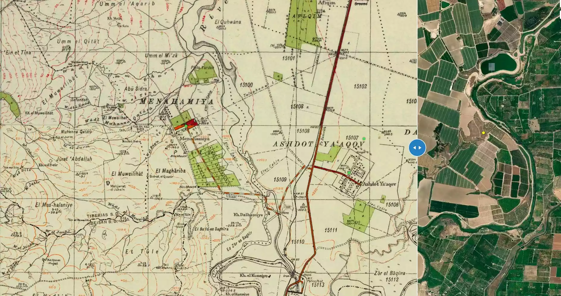
| Map Location | See location #25 on the map View from satellite |
|||||||||||||||
| Military Operation | Possibly Operation Gideon | |||||||||||||||
| Attacking Units | Possibly the Golani Brigade | |||||||||||||||
| Exodus Cause | Expulsion by Zionist troops | |||||||||||||||
| Village Temains | al-Dalhamiyya was completely obliterated and defaced. | |||||||||||||||
| Ethnically Cleansing | al-Dalhamiyya inhabitants were completely ethnically cleansed. | |||||||||||||||
| Pre-Nakba Land Ownership |
**Town Lands' Demarcation Maps |
|||||||||||||||
| Land Usage As of 1945 |
|
|||||||||||||||
| Population |
|
|||||||||||||||
| Number of Houses |
|
|||||||||||||||
| Near By Towns |
||||||||||||||||
|
||||||||||||||||
| Nearby Wadies & Rivers | al-Dalhamiyya is situated on the north bank of the Yarmuk River, on the Palestine-Jordan border. | |||||||||||||||
| Exculsive Jewish Colonies Who Usurped Village Lands |
Ashdot Ya'aqov, Ashdot Ya'aqov Me'uchad, and Menachemya. | |||||||||||||||
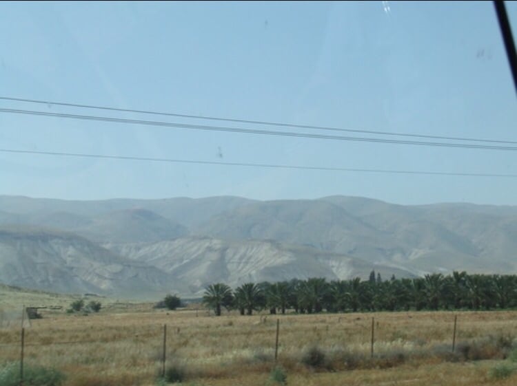
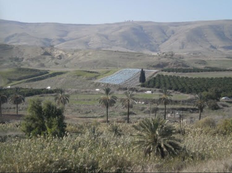
Village Before NakbaThe village was situated in a shallow depression on the north bank of the Yarmuk River, on the Palestine-Jordan border. A spur linked it to the highway between the al-Majami' bridge and the village of Samakh, and another road linked it to al-Baqura, an adjacent village (presently located in Jordan). Initially, al-Dalhamiyya was located on the eastern bank of the Jordan River, but as Zionist land reclamation projects near Lake Tiberias expanded the villagers were displaced, and so they relocated their village farther east, near the Yarmuk. The American biblical scholar and traveler Edward Robinson was told when he was in Palestine in 1838 that the village lay on the eastern bank of the Jordan. [[Robinson (1841) III:264, fn.1]] The village houses were built mostly of adobe brick, with roofing made of straw and reeds. Its population was predominantly Christian.Agriculture, the mainstay of al-Dalhamiyya's economic life, was based on vegetables and citrus. Lands to the north and west of the village were endowed with a silt-rich soil that enhanced their fertility. The villagers relied on the Yarmuk River for irrigation. In 1944/45 a total of 1,709 dunums was allocated to cereals; 29 dunums were irrigated or used for orchards. On the southwestern outskirts of the village was Khirbat al-Dalhamiyya (203228), a mound of ruins and potsherds. Village Occupation and Ethnic CleaningDetails of the occupation of al-Dalhamiyya are unavailable. It was probably captured some time between the attack on Tiberias in mid-April 1948, and the occupation of Baysan and the Baysan Valley in the first half of May. A few nearby villages were occupied at this time in preparation for the 'clearing' of the Baysan Valley. Neighboring Samakh was attacked on 28 April and by 3 May, Zionist settlers in the area told the Jewish National Fund that their surroundings (around the 'Sea of Galilee,' or Lake Tiberias) had been emptied of their Arab inhabitants. According to Israeli historian Benny Morris, these colonists demanded quick action to establish Jewish settlements in the newly depopulated villagesZionists Colonies on Village LandsZionists established the settlement of Ashdot Ya'aqov (204229) southwest of the village in 1933. Ashdot Ya'aqov Me'uchad (204230), founded in 1933, and Menachemya (202230), founded in 1902, are west of the former village. Although they are close to the village site, none are on village lands.Village TodayThe village has been obliterated. There is a banana grove on the site that belongs to the nearby kibbutz, Ashdot Ya'aqov (see photos section).SourceDr. Walid al-Khalidi, 1992: All That Remains. |
||||||||||||||||
| Related Maps | Town Lands' Demarcation Maps خرائط للقضاء توضح حدود القرى والاودية Town's map on MapQuest View from satellite Help us map this town at WikiMapia |
|||||||||||||||
| Related Links | Wikipedia's Page Google Search Google For Images Google For Videos |
|||||||||||||||
| More Information | في كتاب كي لا ننسى في كتاب بلادنا فلسطين المزيد من موقع هوية |
|||||||||||||||
- Village Land In 1990
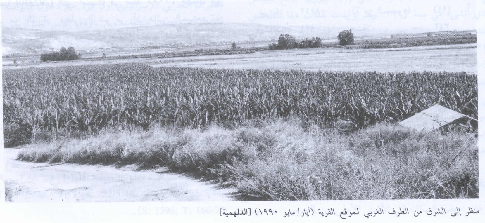
Scanned from "All That Remains" by Dr. Walid Khalidi - من اراضي القريه
Posted by abu raya - اراضي القريه ومن الشرق تظهر الحدود الاردنيه
Posted by abu raya - موقع القريه
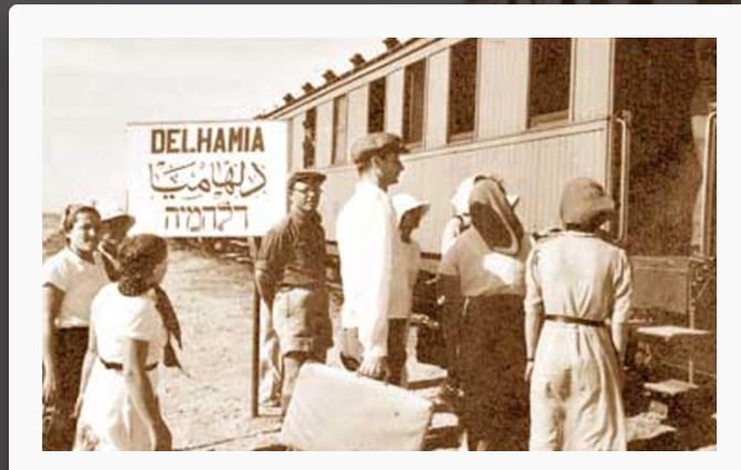
Posted by abu raya - محطه قطار الدلهميه قبل النكبه
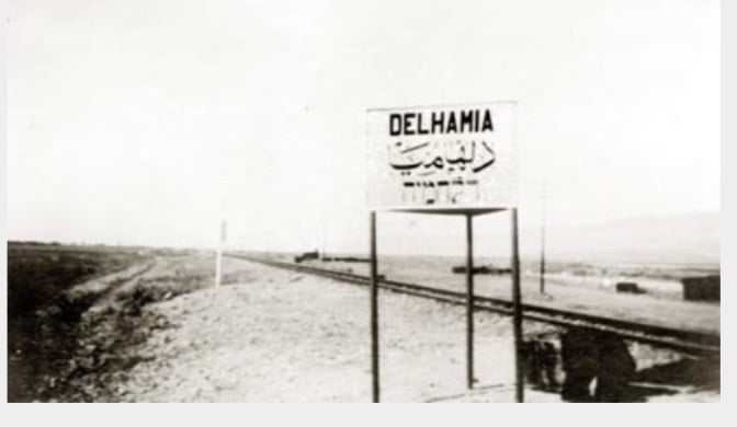
Posted by abu raya - سكه حديد القطار في الدلهميه
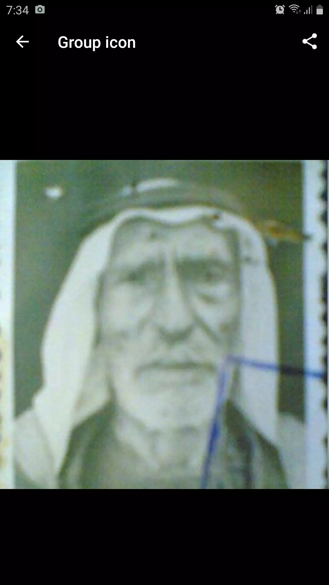
Posted by abu raya - صورة للشيخ الحاج محمد شامخ العلي الهنداوي جد عائلة الشوامخه الهنادي والذي عاش من ١٨٤٠ الى ان توفى بالاردن سنة ١٩٦٧
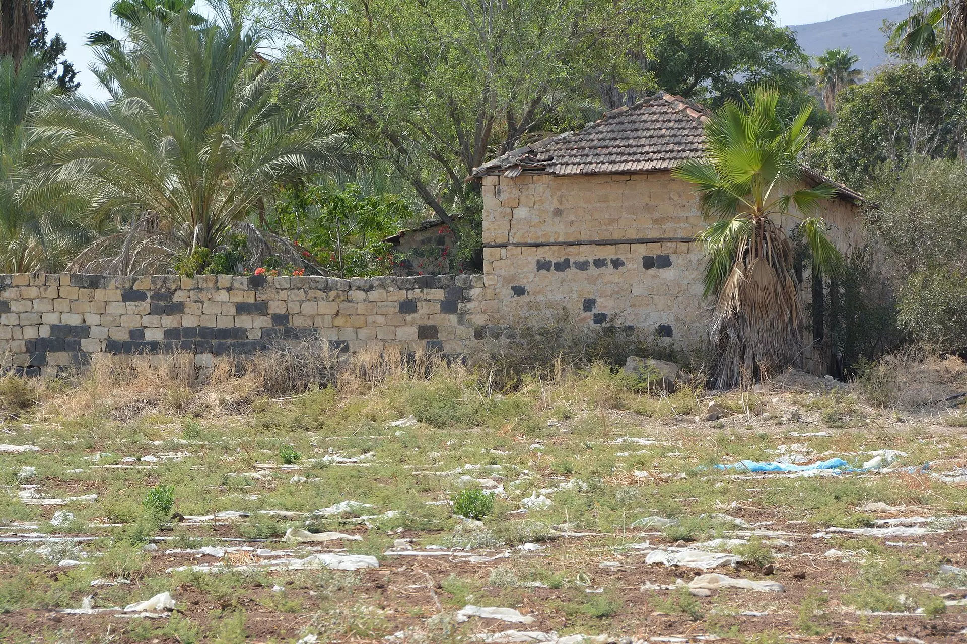
Posted by Majd Hendawi - That is how the "civilized" erased and replaced us: al-Dalhamiyya was completely obliterated except for one remaining structure, as you see -- الدلهمية باتت أثر بعد عين. من هنا مر الهمجّ
Want to browse more? 80,000 pictures were grouped in these gallaries:
| Display Name | Clan/Hamolah | Country of Residence |
No links have been shared yet, be free to the first to share the first link.
 Fake Valor: Why Did Zionist Jews Hoist Nazis Flag on Their Ships in the 1930s?
What is new?
-
Facts About Oct. 7th Gaza Raid
-
Remined Us Please:: Who Did Rape Who? Palestinians Raped Israelis? Or, was the other way around?
-
When Prof. Edward Said was invited to debate Bibi Netanyahu in the 1980s, watch what happened!
-
Ezra Klein of the NY Times on the "Jewish Race".
-
Abusing Blood Libel!
-
Did Israeli Soldiers Activate The Hanniba Direective On Oct. 7th? You Be The Judge
-
Zionist FAQ: Isn't it true that Palestinians don't want peace? Palestinians never accepted the two-state solution
- Facts about Haavara (Transfer) Agreement between Ben-Gurion & Hitler
-
Haavara FAQs: Why Did Zionist Jews Hoist Nazis' Flags on Their Ships in the 1930s?
- Haavara FAQs: When Chaim Weizmann met FDR in mid-1943, why was he silent about rescuing European Jewry?
-
Dear ChatGPT: How did Palestinians resist Napoleon's invasion of their country in 1799?
-
Dear ChatGPT: Gaza had a vibrant Jewish community in the mid-17th century. What happened to them?
-
Dear ChatGPT: Why did the Jewish Agency suppress news of the Holocaust during WWII?
-
Video Playlist: Jews share their DNA tests to end the conflict for good.
-
A Tale of Two Conflicts: Examining the Definition of Genocide
-
Prof. Abraham Polak And The Suppressed History of the Khazars and European Jewry
-
How Ronald Reagan would have framed the genocide in Gaza if he were still alive?
-
Haavara FAQs: Let us do the math: how many German Jews did The Haavara Agreement save?
-
Zionist FAQs: The Hebron Massacre of 1929, "clearly proves" that Palestinians are antisemitic, how could you deny it?
-
Zionist FAQs: Why Anti-Zionist Is Not Antisemitism?
-
Zionist FAQs: Isn't it true that the KGB created Palestinian Nationalism in the early 1960s?
- Zionist FAQs: Muslims are killing Muslims all the time; why are Israeli Jews being singled out in the media?
- Zionist FAQs: How is Israel an apartheid state when 20% of its citizens are Arabs who enjoy full rights?
-
Haavara FAQs: Why Did Dorothy Thompson Flip From A Zionist Advocate to A Silenced Dissenter?
-
Haavara FAQs: Analysis of Herzl's Uganda Scheme and how it could have saved millions of Jews.
-
Haavara FAQs: Why did Hayim Greenberg describe American Jewry as "morally bankrupt" in early 1943?
-
Haavara FAQs: What if the Evian Conference was a resounding success? What would have been the impact of saving European Jewry on Zionism?
- Haavara FAQs: What if the six million were saved, how that would have impacted the Zionist project?
-
Haavara FAQs: How did Zionist leaders react when Europe's Jews lingered in the DP camps after WWII ended?
-
Why does the American Jewish community repeat lies that David Ben-Gurion had debunked before he died?
-
Who has the power to rename the Tatar/Khazar Gene Marker to Jewish IV?
-
Zionist FAQs: Why won't Egypt, Syria, and Jordan take their people back? Jews are indigenous to Palestine, and Arabs immigrated after Jews developed the country. Arabs should leave.
-
Haavara FAQs: Did Hitler and the Nazis conflate between Judaism and Zionist? If that wasn't case, then why?
-
Haavara FAQs: Winston Churchill and antisemitism, a collection of articles written Churchill.
-
Haavara FAQs: Broken by country, how many Jews survived vs. killed during the Holocaust?
-
Haavara FAQs: Why did European Jews vote with their feet and to immigrated to the Americas, not Palestine, after WWII?
-
Watch this American Jewish Girl describing Israeli Jews' cognitive dissonance like no other in under two minutes
-
Haavara FAQs: When the Nazis went out of their way to hide the Holocaust, Israeli Jews did the exact opposite by broadcasting their genocide of Gazans. But why?
-
Haavara FAQs: How Zionist Jews went out of their to show their appreciation to Nazism and Fascism?
- Haavara FAQs: Why Zionist leaders were against bombing the death camps & the Railroads leading to them?
-
Haavara FAQs: Hitler's message to the British and American people: If Jews are such noble citizens and you care about them, how come you're not letting them in? I will gladly ship them to you at my expense, even on luxury liners!
-
A shortlist of Zionist and Israeli false flag operations in the name Jews.
-
The Most Moral Army
- The Land of Kapos (Israel): Where the brave are boycotted and Kapos walk free.
- Why did early Zionists often named their communal enterprises "colonial"?
- Zionist Relations with Nazi Germany by Faris Glubb
-
Two NY Times advertisements by Zionists in the early 1943 that exposes Zionists' treason at the height of the calamity
- Facts Not Lies about the Palestinian-Israeli Conflict.
- Site's pictures have been categorized
- Campgain Against Lice
- A Survey of Palestine, the official source about Palestine before Nakba produced by the British Mandate; over 1200 pages.
- Satellite View & Google Earth: Over 6,000 placemarks identifying all destroyed towns, W. Bank & Gaza Strip Towns, & refugee camps.
- PalestineRemembered.com and its Nakba Oral History Project were featured on al-Jazeera Satellite TV.
- Nakba Oral History Video Podcast:
 Over 700 Oral History interviews (including 3,500+ hours of recording) can be viewed online.
 - Palestine Village Statistics Project
- Gaza Jail Break
- النسخة العربية للموقع الان متوفرة
- Videos: Documenting the destroyed villages in video: Tracing all that remains since Nakba.
- Videos: Responding to Zionist Propaganda
- Interview: The ethnic cleansing of Palestine: George Galloway interviews Israeli Historian Ilan Pappe.
- For Palestinians, memory matters. It provides a blueprint for their future By George Bisharat.
- Zionist FAQ now available in Hebrew שאלות שציונים שואלים, עכשיו בעברית
- Video: The Stephen Walt and John Mearsheimer report on the influence of the Israel Lobby on U.S. Foreign Policy
- The Palestinian-Israeli conflict for beginners
