| PalestineRemembered | About Us | Oral History | العربية | |
| Pictures | Zionist FAQs | Haavara | Maps | |
| Search |
| Camps |
| Districts |
| Acre |
| Baysan |
| Beersheba |
| Bethlehem |
| Gaza |
| Haifa |
| Hebron |
| Jaffa |
| Jericho |
| Jerusalem |
| Jinin |
| Nablus |
| Nazareth |
| Ramallah |
| al-Ramla |
| Safad |
| Tiberias |
| Tulkarm |
| Donate |
| Contact |
| Profile |
| Videos |
Welcome To al-Hamra - الحمرا (אל-חמרא)
|
District of Baysan
Ethnically cleansed days ago |
العربية Google Earth |
| Gallery (7) |
- Statistics & Facts
-
Before & After

- Satellite View
- Articles 1
- Pictures 7
- Oral History 2
- Members 1
- All That Remains
- Wikipedia
- Videos 1
- Guest Book
- Links
| Statistic & Fact | Value | |||||||||||||||||||||
| Occupation Date | May 31, 1948 | |||||||||||||||||||||
| Distance From District | 7.5 (km) South of Baysan | |||||||||||||||||||||
| Elevation | -175 (meters) | |||||||||||||||||||||
| Before & After Nakba, Click Map For Details |
||||||||||||||||||||||

|
||||||||||||||||||||||
| Map Location | See location #27 on the map View from satellite |
|||||||||||||||||||||
| Military Operation | Operation Gideon | |||||||||||||||||||||
| Attacking Units | Possibly Fourth Battalion of Golani Brigade | |||||||||||||||||||||
| Exodus Cause | Influence of fall of, or exoduce from, neighboring town | |||||||||||||||||||||
| Village Temains | al-Hamra was completely obliterated and defaced. | |||||||||||||||||||||
| Ethnically Cleansing | al-Hamra inhabitants were completely ethnically cleansed. | |||||||||||||||||||||
| Pre-Nakba Land Ownership |
**Town Lands' Demarcation Maps |
|||||||||||||||||||||
| Land Usage As of 1945 |
|
|||||||||||||||||||||
| Population |
|
|||||||||||||||||||||
| Near By Towns |
||||||||||||||||||||||
|
|
||||||||||||||||||||||
| Town's Name Through History | The village was named after the Bedouin tribe who settled in the village lands many centuries ago. | |||||||||||||||||||||
| Archeological Sites | al-Hamra contains the following archeological sites dating back to Canaanites period: Tell al-Shuqaf, and Tell Abu Kharaj. | |||||||||||||||||||||
| Exculsive Jewish Colonies Who Usurped Village Lands |
No Israeli settlements on village lands. | |||||||||||||||||||||
| Featured Video | ||||||||||||||||||||||
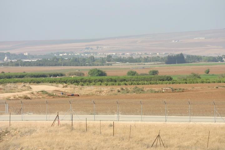
Village Before NakbaThe village, classified as a hamlet by the Palestine Index Gazetteer, was located on the lower slopes of the Golan Heights. It overlooked the al-Hula Plain on all sides except the east and faced the village of al-Muftakhira, about 1 km to the northwest. Wadi al-Dufayla, which drained the Golan Heights, flowed between the two villages in a northeast-southwest direction, turning sharply to the south below al-Muftakhira.Village Occupation and Ethnic CleaningIsraeli military intelligence claimed that the residents of al-Hamra', fearing an attack by Zionist forces, fled in panic on 1 May. The residents of Khiyam al-Walid and Ghuraba (1 km southeast and 3 km south of the village, respectively) left their villages on the same day. Al-Hamra' was seized during Operation Yiftach (see Abil al-Qamh, Safad sub-disctrict). No mention is made of the villagers' destination or the ultimate fate of the village itself.Zionists Colonies on Village LandsThe settlement of Shamir (212285), established in 1944, is about 2 km northeast of the site; it is not on village lands.Village TodayThe entire site is fenced in and serves as an Israeli cow pasture (see photo). Two houses built of stone without mortar stand on the site. The remains of some black basalt walls are also visible.SourceDr. Walid al-Khalidi, 1992: All That Remains. |
||||||||||||||||||||||
| Related Maps | Town Lands' Demarcation Maps خرائط للقضاء توضح حدود القرى والاودية Town's map on MapQuest View from satellite Help us map this town at WikiMapia |
|||||||||||||||||||||
| Related Links | Wikipedia's Page Google Search Google For Images Google For Videos |
|||||||||||||||||||||
| More Information | في كتاب كي لا ننسى المزيد من موقع هوية |
|||||||||||||||||||||
- التقطت هذة الصورة لقرية الحمرا بتاريخ 26/10/2007
Posted by مخلص الغرير 1 - موقع القريه تم تحويله الى اراضي زراعيه يستغلها المستوطنين
Posted by abu raya - اراضي القريه
Posted by abu raya - اراضي القريه
Posted by abu raya - عين الماء من شرق القريه
Posted by abu raya - عين مياه القريه
Posted by abu raya - اراضي القريه
Posted by abu raya
Want to browse more? 80,000 pictures were grouped in these gallaries:
| Display Name | Clan/Hamolah | Country of Residence |
| ركان محمود المريخات | الصقور | مخيم الحصن - إربد, الأردن |
- الذاكرة مفتاح العودة -الحلقة 73- قرية الحمرا Duration: 24 min 49 sec
No links have been shared yet, be free to the first to share the first link.


