| PalestineRemembered | About Us | Oral History | العربية | |
| Pictures | Zionist FAQs | Haavara | Maps | |
| Search |
| Camps |
| Districts |
| Acre |
| Baysan |
| Beersheba |
| Bethlehem |
| Gaza |
| Haifa |
| Hebron |
| Jaffa |
| Jericho |
| Jerusalem |
| Jinin |
| Nablus |
| Nazareth |
| Ramallah |
| al-Ramla |
| Safad |
| Tiberias |
| Tulkarm |
| Donate |
| Contact |
| Profile |
| Videos |
Welcome To al-Khunayzir - الخنيزر (ערב אל-ח'ניזיר)
|
District of Baysan
Ethnically cleansed days ago |
العربية Google Earth |
| Gallery (15) |
- Statistics & Facts
-
Before & After

- Satellite View
- Articles 1
- Pictures 15
- Aerial Views 1
- Oral History 1
- Members
- All That Remains
- Wikipedia
- Videos
- Guest Book
- Links
| Statistic & Fact | Value | ||||||||||||||||||
| Occupation Date | May 20, 1948 | ||||||||||||||||||
| Distance From District | 10 (km) South of Baysan | ||||||||||||||||||
| Elevation | -200 (meters) | ||||||||||||||||||
| Before & After Nakba, Click Map For Details |
|||||||||||||||||||

|
|||||||||||||||||||
| Map Location | See location #28 on the map View from satellite |
||||||||||||||||||
| Military Operation | Operation Gideon | ||||||||||||||||||
| Attacking Units | Golani Brigade | ||||||||||||||||||
| Exodus Cause | Influence of fall of, or exoduce from, neighboring town | ||||||||||||||||||
| Village Temains | The village was completely destroyed, and only the village cemetery remained. | ||||||||||||||||||
| Ethnically Cleansing | al-Khunayzir inhabitants were completely ethnically cleansed. | ||||||||||||||||||
| Pre-Nakba Land Ownership |
**Town Lands' Demarcation Maps |
||||||||||||||||||
| Land Usage As of 1945 |
|
||||||||||||||||||
| Population |
|
||||||||||||||||||
| Number of Houses |
|
||||||||||||||||||
| Near By Towns |
|||||||||||||||||||
|
|||||||||||||||||||
| Town's Name Through History | al-Khunayzir was also known by 'Arab al-Khunayzir. | ||||||||||||||||||
| Water Supply | The springs of 'Uyun Umm al-Faraj and 'Ayn al-Khanazir used to supply the village with its water supplies. | ||||||||||||||||||
| Archeological Sites | The village contains Tall Abu al-Fare which was used by the villagers as a cemetery. | ||||||||||||||||||
| Exculsive Jewish Colonies Who Usurped Village Lands |
Tirat Tzvi | ||||||||||||||||||
| Featured Video | |||||||||||||||||||
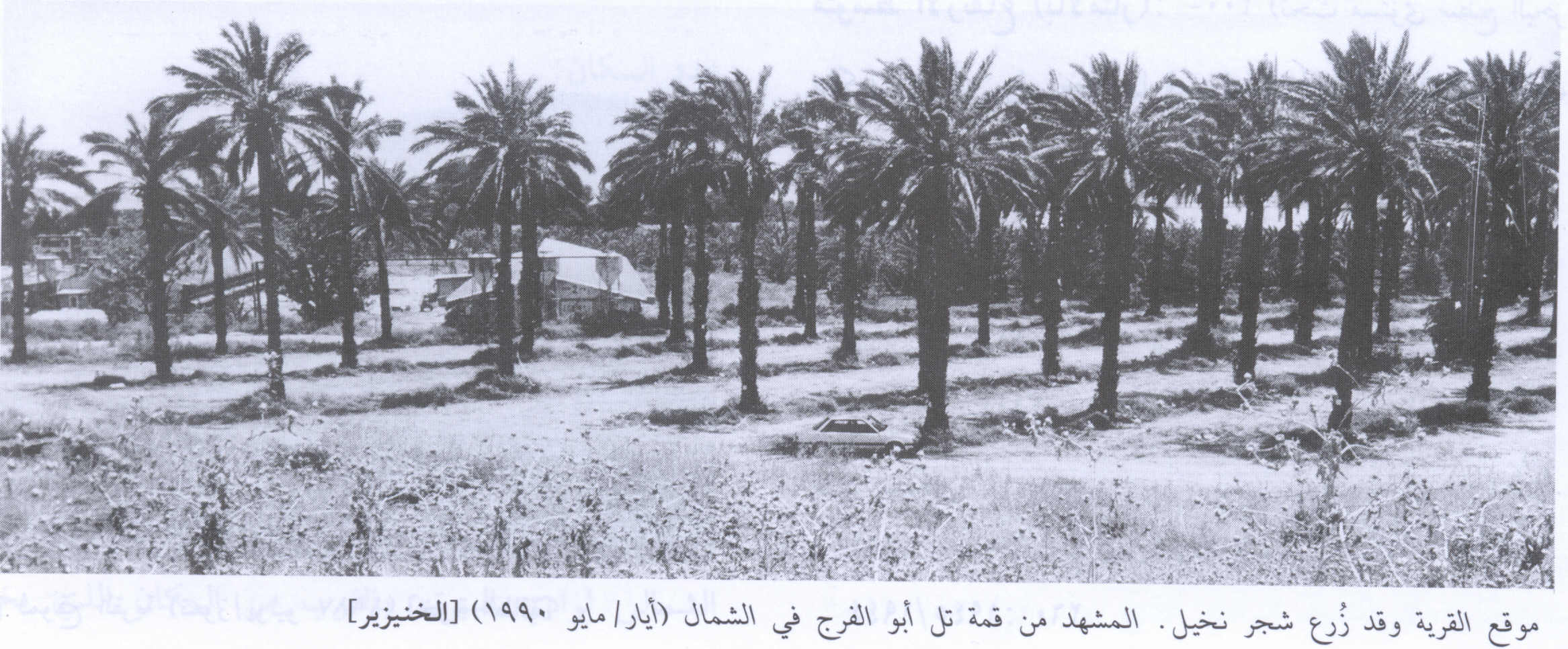
Village Before NakbaThe village stood on flat terrain on the western edge of the village of al-Zarra'a, which diminished in size after the establishment of the Jewish colony of Tirat Tzvi in 1937. A secondary road linked it to the Baysan-Jericho highway, and other roads connected it to adjacent villages. AI-Khunayzir was initially a seasonal campsite for nomadic Bedouin who eventually settled there year round. Their dwellings, both adobe houses and tents, were dispersed over a wide area. All of the people of al-Khunayzir were Muslims. They drew water from springs north and southeast of the site for domestic use as well as for crop irrigation. They grew fruit, vegetables, and grain. In 1944/45 a total of 18 dunums was devoted to citrus and bananas and 256 dunums were allocated to cereals; 1,658 dunums were irrigated or used for orchards.Zionists Colonies on Village LandsThe settlement of Tirat Tzvi was established on the lands of the villages of al-Khunayzir and al-Zarra'a in 1937.Village TodayThe only remaining landmark is a cemetery on Tall Abu al-Faraj , north of the site. To the north and west of this tell are the springs of Uyun Umm al-Faraj and Ayn al-Khanazir. Most of the village site and the land around it are covered with palm trees.SourceDr. Walid al-Khalidi, 1992: All That Remains. |
|||||||||||||||||||
| Related Maps | Town Lands' Demarcation Maps خرائط للقضاء توضح حدود القرى والاودية Town's map on MapQuest View from satellite Help us map this town at WikiMapia |
||||||||||||||||||
| Related Links | Wikipedia's Page Google Search Google For Images Google For Videos |
||||||||||||||||||
| More Information | في كتاب كي لا ننسى في كتاب بلادنا فلسطين المزيد من موقع هوية |
||||||||||||||||||
- Village Site in 1990
Scanned from "All That Remains" by Dr. Walid Khalidi - قرية الخنيزر التقطت الصورة بتاريخ 26/10/2007
Posted by مخلص الغرير - صوره لاحد سكان القريه برفقه سكان المستوطنه التي بقرب القريه
Posted by abu raya - اراضي القريه والمستوطنه التي بجانبها قبل النكبه
Posted by abu raya - القريه والمستوطنه القريبه منها
Posted by abu raya - صوره من القريه في بدايه قدوم المستوطنين
Posted by abu raya - البيوت العربيه التي استولى عليها المستوطنون
Posted by abu raya - المستوطنون عند قدومهم للقريه
Posted by abu raya - احد سكان القريه برفقه المستوطنين
Posted by abu raya - اراضي وموقع القريه والمستعمره المقامه عليها
Posted by abu raya - نبع الخنازير شمال القريه
Posted by abu raya - نبع الخنازير شمال القريه
Posted by abu raya - نبع الخنازير
Posted by abu raya - اراضي القريه يستغلها المستعمرون لزراعه النخيل
Posted by abu raya - نبع الخنازير شمال القريه
Posted by abu raya
Want to browse more? 80,000 pictures were grouped in these gallaries:
| Display Name | Clan/Hamolah | Country of Residence |
No links have been shared yet, be free to the first to share the first link.


