| PalestineRemembered | About Us | Oral History | العربية | |
| Pictures | Zionist FAQs | Haavara | Maps | |
| Search |
| Camps |
| Districts |
| Acre |
| Baysan |
| Beersheba |
| Bethlehem |
| Gaza |
| Haifa |
| Hebron |
| Jaffa |
| Jericho |
| Jerusalem |
| Jinin |
| Nablus |
| Nazareth |
| Ramallah |
| al-Ramla |
| Safad |
| Tiberias |
| Tulkarm |
| Donate |
| Contact |
| Profile |
| Videos |
Welcome To Sa'sa', Khirbat - خربة سعْسع (ח'ירבת סעסע)
|
District of Haifa
Ethnically cleansed days ago |
العربية Google Earth |
| Gallery (3) |
- Statistics & Facts
-
Before & After

- Satellite View
- Articles 1
- Pictures 3
- Oral History 3
- Members 3
- All That Remains
- Wikipedia
- Videos 1
- Guest Book
- Links
| Statistic & Fact | Value | ||||||||||
| Occupation Date | April 28, 1948 | ||||||||||
| Distance From District | 15 (km) East of Haifa | ||||||||||
| Elevation | 50 (meters) | ||||||||||
| Before & After Nakba, Click Map For Details |
|||||||||||

|
|||||||||||
| Map Location | See location #5 on the map View from satellite |
||||||||||
| Military Operation | Possibly Bi'ur Chametz | ||||||||||
| Attacking Units | Some unknown units from the Haganah. | ||||||||||
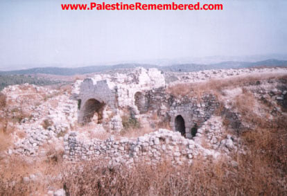
| Village Temains | The village has been completely destroyed, and only house rubble left behind. | ||||||||||
| Ethnically Cleansing | Sa'sa', Khirbat inhabitants were completely ethnically cleansed. | ||||||||||
| Population |
|
||||||||||
| Number of Houses | In (1931): 234 (includes Wa'arat al-Sarris and 8 other villages) | ||||||||||
| Near By Towns |
|||||||||||
|
|||||||||||
| Town's Name Through History | The Romans referred to the village by Kefar Sasai | ||||||||||
| Archeological Sites | Khirbat Sa'sa' contained building foundations, tombs carved in rocks, cisterns, and caves. Also Khirbat Jabyatha, an artificial mound with exposed wall fragments. | ||||||||||
| Exculsive Jewish Colonies Who Usurped Village Lands |
No settlements on the village lands | ||||||||||
| Featured Video | |||||||||||
Village Before NakbaThe village was located on a round, slightly elevated mound overlooking the eastern edge of the plain of Haifa. Since scholars have identified the site as that of Roman Kefar Sasai, it is probable that at least part of the ruins visible in Khirbat Sa'sa date to the early centuries A.D. Kefar Sasai is known to have been a village near the ancient boundary of Ptolemais (Acre) and Sepphoris (later Saffuriyya, in Nazareth sub-disctrict). Khirbat Sa'sa' was classified as a hamlet by the Palestine Index Gazetteer in the Mandate era. Ruins on the site included building foundations, tombs carved in rocks, cisterns, and caves. South of the village lay Khirbat Jabyatha, an artificial mound with exposed wall fragments.Village Occupation and Ethnic CleaningKhirbat Sa'sa' was in an area in which some other villages were seized in the early weeks of the war. However, the bulk of the communities in the vicinity were captured on the heels of the fall of Haifa, during the last week of April 1948. If the village remained unoccupied until the end of April, it was probably captured at this time by Haganah units who sought to consolidate their hold on Haifa.Zionists Colonies on Village LandsThere are no Israeli settlements on the village lands, which have been amalgamated with those of the Arab town of Shafa Amr.Village TodayCactuses and fig trees can be found scattered about the site. There are a number of partially collapsed stone walls, one with a large arched opening. The surrounding lands are used as a grazing area.SourceDr. Walid al-Khalidi, 1992: All That Remains. |
|||||||||||
| Related Maps | Town Lands' Demarcation Maps خرائط للقضاء توضح حدود القرى والاودية Town's map on MapQuest View from satellite Help us map this town at WikiMapia |
||||||||||
| Related Links | Wikipedia's Page Google Search Google For Images Google For Videos |
||||||||||
| More Information | في كتاب كي لا ننسى في كتاب بلادنا فلسطين المزيد من موقع هوية |
||||||||||
Want to browse more? 80,000 pictures were grouped in these gallaries:
| Display Name | Clan/Hamolah | Country of Residence |
| Ahmad Abou Alardat | Abou Alardat | Germany, Germany |
| Maher Abu Khazneh | - | - |
| Ayoub Abou Khazneh | Abou Khazneh | Denmark, Denmark |
- في موقع مقبرة خربة سعسع المهجرة (قضاء حيفا ) Duration: min 2 sec
No links have been shared yet, be free to the first to share the first link.


