| PalestineRemembered | About Us | Oral History | العربية | |
| Pictures | Zionist FAQs | Haavara | Maps | |
| Search |
| Camps |
| Districts |
| Acre |
| Baysan |
| Beersheba |
| Bethlehem |
| Gaza |
| Haifa |
| Hebron |
| Jaffa |
| Jericho |
| Jerusalem |
| Jinin |
| Nablus |
| Nazareth |
| Ramallah |
| al-Ramla |
| Safad |
| Tiberias |
| Tulkarm |
| Donate |
| Contact |
| Profile |
| Videos |
Welcome To Yajur - ياجور (יאג'ור)
|
District of Haifa
Ethnically cleansed days ago |
العربية Google Earth |
| Gallery (30) |
- Statistics & Facts
-
Before & After

- Satellite View
- Articles 5
- Pictures 30
- Aerial Views 1
- Land Deeds 1
- Oral History 3
- Members 18
- All That Remains
- Wikipedia
- Videos 3
- Guest Book 12
- Links 1
| Statistic & Fact | Value | |||||||||||||||||||||
| Occupation Date | April 25, 1948 | |||||||||||||||||||||
| Distance From District | 9.5 (km) South East of Haifa | |||||||||||||||||||||
| Elevation | 25 (meters) | |||||||||||||||||||||
| Before & After Nakba, Click Map For Details |
||||||||||||||||||||||

|
||||||||||||||||||||||
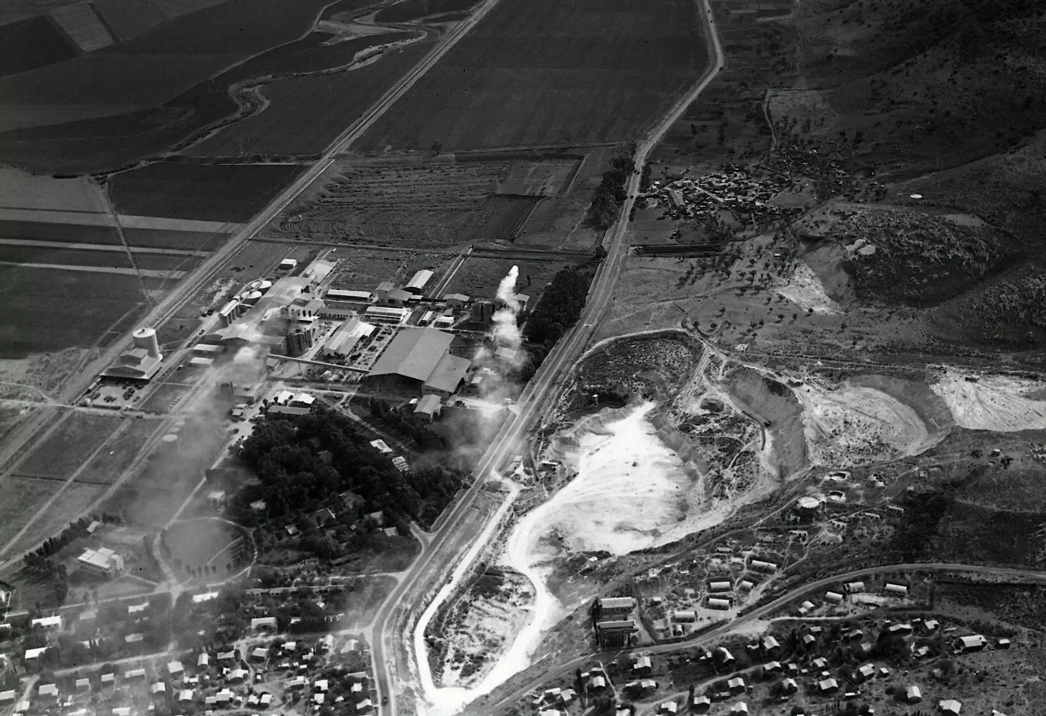
| Pre-Nakba Aerial View |
||||||||||||||||||||||

|
||||||||||||||||||||||
| Map Location | See location #7 on the map View from satellite |
|||||||||||||||||||||
| Military Operation | Possibly Operation Bi'ur Chametz | |||||||||||||||||||||
| Exodus Cause | Military assault by Zionist troops | |||||||||||||||||||||
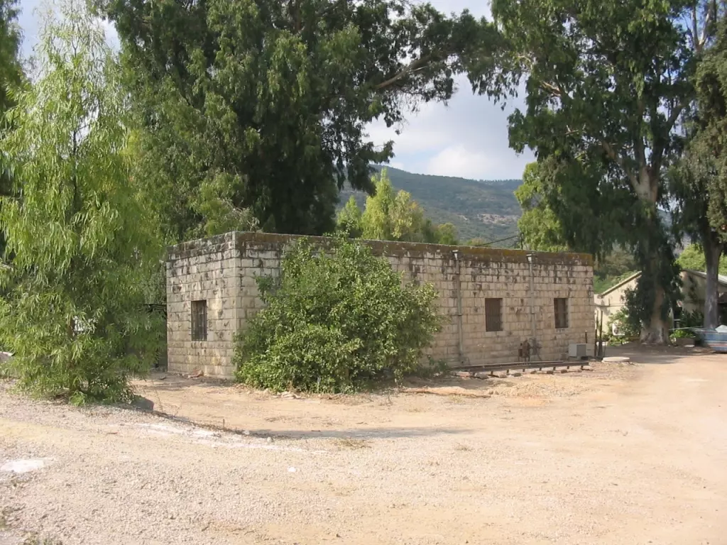
| Village Temains | The village has been completely obliterated | |||||||||||||||||||||
| Ethnically Cleansing | Yajur inhabitants were completely ethnically cleansed. | |||||||||||||||||||||
| Pre-Nakba Land Ownership |
**Town Lands' Demarcation Maps |
|||||||||||||||||||||
| Land Usage As of 1945 |
|
|||||||||||||||||||||
| Population |
|
|||||||||||||||||||||
| Number of Houses |
|
|||||||||||||||||||||
| Near By Towns |
||||||||||||||||||||||
|
||||||||||||||||||||||
| Archeological Sites | Yajur contained fragments of glass, building foundations, and tombs with sarcophagi. | |||||||||||||||||||||
| Exculsive Jewish Colonies Who Usurped Village Lands |
Yagur & Nesher | |||||||||||||||||||||
| Featured Video | ||||||||||||||||||||||
Village Before NakbaThe village stood on the lower slopes of Mount Carmel, facing northeast. The Haifa-Jenin highway passed northeast of it. Yajur was one of several villages whose lands were sold by the Ottoman government to two Lebanese merchants, Sursuq and Salim al-Khuri, in 1872. They in turn sold many of these lands to Zionists, who in 1922 established the settlement of Yagur on the land (see also Wadi al-Hawarith, Tulkarrn sub-disctrict). The Arab residents included 560 Muslims and 50 Christians in the mid-1940s; their houses were scattered across the mountain slopes. In 1944/45 a total of 261 dunums of their land was allotted to cereals 57 dunums were irrigated or used for orchards, of which 42 dunums were planted with olive trees. Although Yajur has not been identified with any ancient historical site, there is evidence of the village's antiquity, including fragments of glass, building foundations, and tombs with sarcophagi.Village Occupation and Ethnic CleaningYajur was one of the villages in the vicinity of Haifa that was captured immediately after the fall of the city. After the Haganah launched a major attack on Balad al-Shaykh, a large village just to the northeast of Yajur, the villagers decided not to wait for a similar assault. Israeli historian Benny Morris states that they evacuated on 24 or 25 April 1948, a couple of days after Haifa was captured. The New York Times reported a direct military strike against this village at the same time. The Times correspondent wrote that Yajur was one of three villages 'commanding' the eastern approaches to Haifa that was occupied on 24 April in order 'to create a protective zone and seal off Haifa from counter attacks.' After its occupation, the Haganah turned its attention further north, to Acre.Zionists Colonies on Village LandsZionists established the settlement of Yagur in 1922 on what were traditionally village lands. The settlement of Nesher , founded in 1925 on lands that formerly belonged to Balad al-Shaykh, is close by, to the north.Village TodayNo traces of the houses remain on the site, which is marked by numerous fig trees and a smaller number of olive trees. Cement factories occupy part of the surrounding lands. The Israeli settlement of Yagur occupies other parts of the land and uses them for agriculture.SourceDr. Walid al-Khalidi, 1992: All That Remains. |
||||||||||||||||||||||
| Related Maps | Town Lands' Demarcation Maps خرائط للقضاء توضح حدود القرى والاودية Town's map on MapQuest View from satellite Help us map this town at WikiMapia |
|||||||||||||||||||||
| Related Links | Wikipedia's Page Google Search Google For Images Google For Videos |
|||||||||||||||||||||
| More Information | في كتاب كي لا ننسى في كتاب بلادنا فلسطين المزيد من موقع هوية |
|||||||||||||||||||||
- General View Of Village Site In 1987
Scanned from "All That Remains" by Dr. Walid Khalidi - This is a Painting from my Onkel Ibrahim Kheite known as Ghannam
Posted by Hassan Kheite 3 - بيت متبقي في قرية الياجور والتي أقيم على أرضها اليوم كيبوتس ياغور 10/2004
Posted by Makbula Nassar 3 - Nasher cement factory looking northwest from Yajur, note the refinary in the background
2 - British map 1946
Posted by said - ما تبقى من بيوت القريه
Posted by abu raya - من بيوت القريه
Posted by abu raya - صبار القريه
Posted by abu raya - زيتون القريه
Posted by abu raya - ياجور
Posted by abu raya - ياجور
Posted by abu raya - مقبره القريه
Posted by abu raya - صورة نادرة من الياجور قضاء حيفا سنة 1936
- قرية الياجور المدمرة قضاء حيفا(صورة نادرة)سنة 1940
- Aerial View of Nesher plant showing Yajur at the top right hand corner (southwest),_1946
- كوشان ارض لمحمد حصري في قرية للياجور المهجرة
- في موقع قرية الياجور (قضاء حيفا ) ومقبرتها
- في موقع قرية الياجور (قضاء حيفا ) ومقبرتها #2
- السجلات العثمانية _ سجل نفوس رب الاسرة من سجلات المخاتير العثمانية ياجور
Posted by Wadi Alhawarith - السجلات العثمانية _ سجل نفوس رب الاسرة من سجلات المخاتير العثمانية ياجور
Posted by Wadi Alhawarith - جولة في المقبرة
- جولة في المقبرة #2
- جولة في المقبرة #3
- جولة في المقبرة #4
- جولة في المقبرة #5
- جولة في المقبرة #6
- That is how the "civilized" erased and replaced us: Yajur was completely obliterated, as you see -- ياجور باتت أثر بعد عين. من هنا مر الهمجّ
- That is how the "civilized" erased and replaced us: Yajur was completely obliterated, as you see -- ياجور باتت أثر بعد عين. من هنا مر الهمجّ
#2
- That is how the "civilized" erased and replaced us: Yajur was completely obliterated, as you see -- ياجور باتت أثر بعد عين. من هنا مر الهمجّ
#3
- That is how the "civilized" erased and replaced us: Yajur was completely obliterated, as you see -- ياجور باتت أثر بعد عين. من هنا مر الهمجّ
#4
Want to browse more? 80,000 pictures were grouped in these gallaries:
| Display Name | Clan/Hamolah | Country of Residence |
| khodor | chehadi | - |
| abo rayan | - | baalbeck |
| Nahed Kheite | دار منصور | NRW, GERMANY |
| انس البعجاوي | البعجاوي | المنسي, المنسي |
| محمد ابو حشمه | ابو حشمه | - |
| FADI | fadi al audi | shouf, lebanon |
| ابوكرم | حجاب | jordan |
| ابوعدنان | حجاب | irbid, jordan |
| Yousef Khalil | - | Abudhabi, United Arab Emirates |
| Amani Khalil | - | Abudhabi, United Arab Emirates |
| Dana Khalil | - | Abudhabi, UAE |
| jomaa | - | sweden |
| Mustafa Chehade | - | - |
| mohammed abo shakra | - | DANMARK |
| Hossam | - | UK, UK |
| AOK | - | Kuala Lumpur, Malaysia |
| saleh | yaior | bekaa, lebanon |
| Hassan Kheite | - | NRW, Germany |
- Ibrahim Ghannam About Al-Yajour
- ياجور...وطني
- ياجور 2012 Duration: 12 min 38 sec


