| PalestineRemembered | About Us | Oral History | العربية | |
| Pictures | Zionist FAQs | Haavara | Maps | |
| Search |
| Camps |
| Districts |
| Acre |
| Baysan |
| Beersheba |
| Bethlehem |
| Gaza |
| Haifa |
| Hebron |
| Jaffa |
| Jericho |
| Jerusalem |
| Jinin |
| Nablus |
| Nazareth |
| Ramallah |
| al-Ramla |
| Safad |
| Tiberias |
| Tulkarm |
| Donate |
| Contact |
| Profile |
| Videos |
Welcome To Saliha - صلحة (צאלחה)
|
District of Safad
Ethnically cleansed days ago |
العربية Google Earth |
| Gallery (32) |
- Statistics & Facts
-
Before & After

- Satellite View
- Articles 3
- Pictures 32
- Aerial Views 1
- Oral History 5
- Members 4
- All That Remains
- Wikipedia
- Videos
- Guest Book 9
- Links
| Statistic & Fact | Value | ||||||||||||||
| Occupation Date | October 30, 1948 | ||||||||||||||
| Distance From District | 12 (km) North of Safad | ||||||||||||||
| Elevation | 675 (meters) | ||||||||||||||
| Before & After Nakba, Click Map For Details |
|||||||||||||||

|
|||||||||||||||
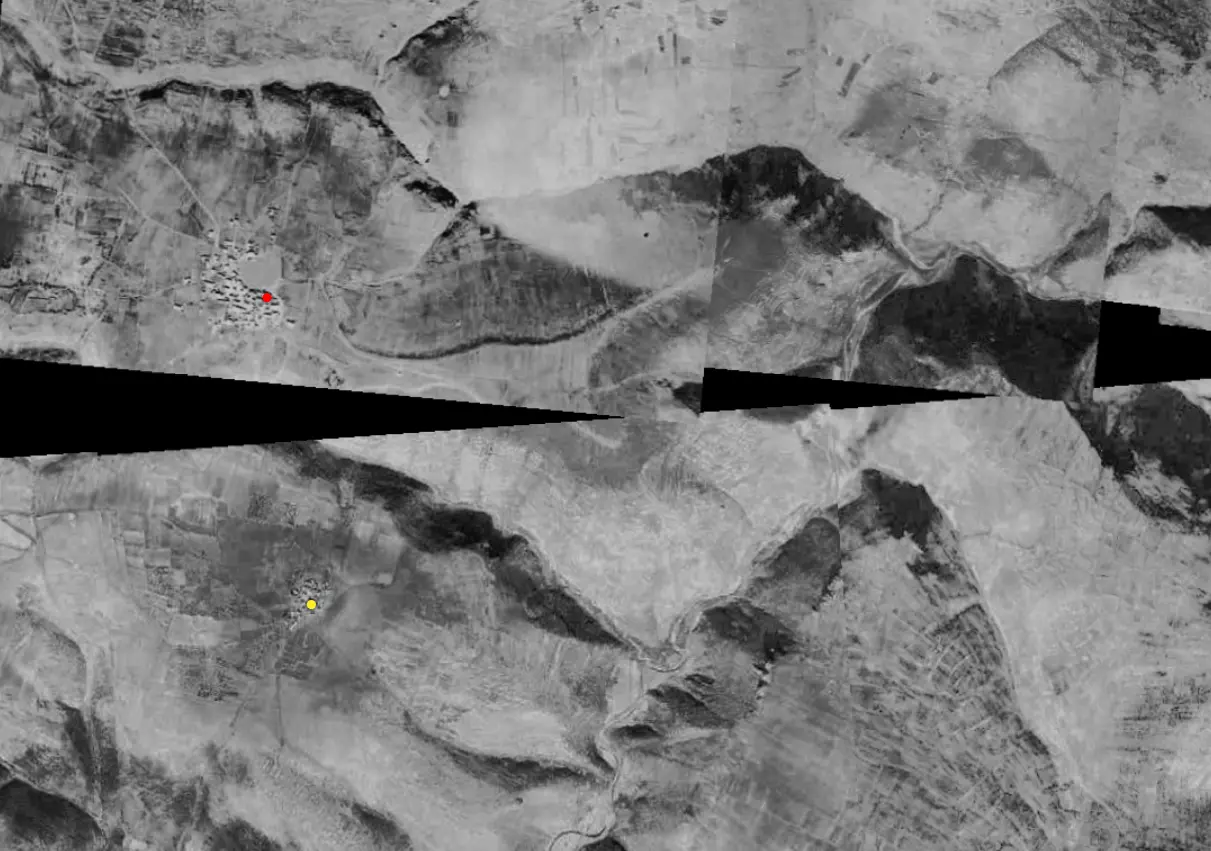
| Pre-Nakba Aerial View |
|||||||||||||||

|
|||||||||||||||
| Map Location | See location #35 on the map View from satellite |
||||||||||||||
| Military Operation | Operation Hiram | ||||||||||||||
| Attacking Units | The massacre of 94 people by the terror soldiers of Sheva' (Seventh) Brigade | ||||||||||||||
| Acts of Terror | Massacre occured by Zionist troops against the town's inhabitants. | ||||||||||||||
| Exodus Cause | Military assault by Zionist troops | ||||||||||||||
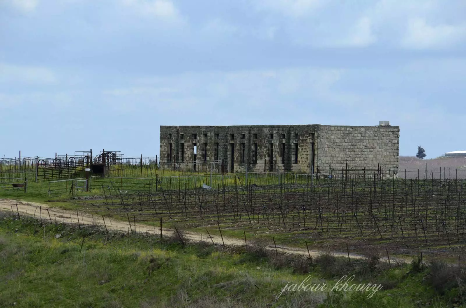
| Village Temains | The village has been mostly destroyed with the exception of the deserted village school | ||||||||||||||
| Ethnically Cleansing | Saliha inhabitants were completely ethnically cleansed. | ||||||||||||||
| Pre-Nakba Land Ownership |
**Town Lands' Demarcation Maps |
||||||||||||||
| Land Usage As of 1945 |
|
||||||||||||||
| Population |
|
||||||||||||||
| Number of Houses |
|
||||||||||||||
| Schools | Saliha had an elementary school for boys. | ||||||||||||||
| Nearby Wadies & Rivers | The village stood on a plain at the edge of a steep wadi, called Wadi Saliha. | ||||||||||||||
| Exculsive Jewish Colonies Who Usurped Village Lands |
Yir'on and Avivim | ||||||||||||||
Village Before NakbaThe village stood on a plain at the edge of a steep wadi, called Wadi Saliha; it was in the Upper Galilee Mountains, next to the Lebanese border. A path linked it to two roads, one leading to the coastal highway and another going to Safad. In the late nineteenth century Saliha was a village of about 200 people who cultivated gardens in the surrounding area and built their homes out of basalt stones mortared with mud. They took their drinking water from several cisterns and a large pond. [SWP (1881) I:202-3] Its population was predominantly Muslim. It had an elementary school for boys. In 1944/45 a total of 7,401 dunums of its land was allocated to cereals; 422 dunums were irrigated or used for orchards. Artifacts in the village included rock-cut tombs, traces of mosaic floors, and oil presses. The nearby Khirbat al-Sanifa also contained ancient relics, such as a circular pressing floor.Village Occupation and Ethnic CleaningCiting Arab military sources in Amman, the United Press reported that Saliha (along with Kafr Bir'im) was occupied by Israeli forces on 18 May. The occupation may have been only temporary, because Israeli sources cited by historian Benny Morris state that a massacre was perpetrated at Saliha on 30 October 1948, at the end of Operation Hiram (see 'Arab al-Samniyya, Acre sub-disctrict).An account of the October massacre was given by Israel Galili, the former head of the Haganah National Staff, to a meeting of Mapam party officials. Galili briefed the meeting on a number of atrocities committed during Operation Hiram, especially by the Sheva' (Seventh) Brigade. He said that at Saliha, ninety-four people 'were blown up with a house.' The Sheva' Brigade had been ordered to proceed from the village of Sa'sa' in a northeast direction, to occupy al-Malikiyya. Along the way, its forces 'encountered light resistance' near Saliha, according to the History of the War of Independence. But the Haganah account gives no details of the military action taken in response. If any villagers survived the Saliha massacre, they were probably expelled, along with the residents of most border villages. [M:230; NYT:19/5/48; T:325‒26] Zionists Colonies on Village LandsIsrael founded the settlement of Yir'on (192275) on the village site in 1949. In 1960, the settlement of Avivim (194277) was constructed on village lands, northeast of the village site. [M:xx]Village TodayThe only remaining landmark is a long building (which may have been a school) with many high windows. The site is a flat, mostly cultivated area. The bulk of surrounding land is planted by Israeli farmers with apple trees.SourceDr. Walid al-Khalidi, 1992: All That Remains. |
|||||||||||||||
| Related Maps | Town Lands' Demarcation Maps خرائط للقضاء توضح حدود القرى والاودية Town's map on MapQuest View from satellite Help us map this town at WikiMapia |
||||||||||||||
| Related Links | Wikipedia's Page Google Search Google For Images Google For Videos |
||||||||||||||
| More Information | في كتاب كي لا ننسى في كتاب بلادنا فلسطين المزيد من موقع هوية |
||||||||||||||
- saliha
Posted by ziad sukkar - الجهه الشرقيه من التله التي كان يقع عليها مركز القريه
Posted by Jabour Khoury - المنحدرات الشرقيه للتله التي كانت تقع عليها القريه وقد تم شق شارع واسع يقسم التله الى قسمين
Posted by Jabour Khoury - المنحدرات الشرقيه للقريه وفي المقابل اراضي قريه فاره ويمر بينهما وادي فاره
Posted by Jabour Khoury - الاراضي في الجهه الشرقيه من القريه بعض ردم البيوت واشجار اللوز المزهر
Posted by Jabour Khoury - الجهه الشرقيه الشماليه وتظهر اشجار الزيتون ونبات الصبار وبقايا احد البيوت
Posted by Jabour Khoury - بقايا البيت الظاهر في الصوره السابقه عن قرب
Posted by Jabour Khoury - نبات الصبار المحيط بمستوطنه يارؤن المقامه على اراضي القريه
Posted by Jabour Khoury - مدرسه القريه البناء الوحيد المتبقى وتقع الى الشرق من القريه
Posted by Jabour Khoury - مدرسه القريه
Posted by Jabour Khoury 1 - اراضي القريه المزروعه بكروم العنب
Posted by Jabour Khoury - اشجار الزيتزن والرمان والتين في الجهه الغربيه من القريه وعلى التل المقابل تظهر بلده يارون اللبنانيه
Posted by Jabour Khoury - اشجار التين والزيتون في الجهه الغربيه من القريه
Posted by Jabour Khoury - مركز القريه والسياج المضروب حولها ويمنع الدخول اليها وهي تقع في مركز المستوطنه المقامه على اراضيها
Posted by Jabour Khoury - مركز القريه وأثار ردم البيوت والمباني في المكان الذي اقيمت به متنزه وحديقه حيوان مصغره
Posted by Jabour Khoury - مركز القريه نظره من الشمال الى الجنوب
Posted by Jabour Khoury - بقايا احد البيوت في مركز القريه
Posted by Jabour Khoury - مركز القريه
Posted by Jabour Khoury - اثاث احد البيوت المهدم وسرير محطم
Posted by Jabour Khoury - منظر من شمال القريه
Posted by abu raya - اشجار الزيتون في الصالحه
Posted by abu raya - اراضي القريه يستغلها المستوطنون لزراعه العنب
Posted by abu raya - بقايا بيوت القريه واراضيها
Posted by abu raya - اراضي القريه وجبالها
Posted by abu raya - مدرسه القريه
Posted by abu raya - مغر القريه
Posted by abu raya - منظر من جنوب القريه
Posted by abu raya - شمال القريه تم تحويله الى حديقه حيوانات
Posted by abu raya - جنوب القريه
Posted by abu raya - الربيع في القريه
Posted by abu raya - صوره قديمه يظهر بها اهالي الصالحه يرفعون الاعلام البيضاء قبل المجزره
Posted by abu raya - Pre-Nakba Aerial view of the village / صورة من الجو للقرية اخذت قبل النكبة
Want to browse more? 80,000 pictures were grouped in these gallaries:
| Display Name | Clan/Hamolah | Country of Residence |
| Fatima Saleh | - | Sydney, Australia |
| Ali Aoun | - | - |
| samer mostafa | - | - |
| kholoud Abed Ahmed kassir | - | Jeddah, Saudi Arabia |
No links have been shared yet, be free to the first to share the first link.


