| PalestineRemembered | About Us | Oral History | العربية | |
| Pictures | Zionist FAQs | Haavara | Maps | |
| Search |
| Camps |
| Districts |
| Acre |
| Baysan |
| Beersheba |
| Bethlehem |
| Gaza |
| Haifa |
| Hebron |
| Jaffa |
| Jericho |
| Jerusalem |
| Jinin |
| Nablus |
| Nazareth |
| Ramallah |
| al-Ramla |
| Safad |
| Tiberias |
| Tulkarm |
| Donate |
| Contact |
| Profile |
| Videos |
Welcome To Hulayqat - حليقات (חוליקאת)
|
District of Gaza
Ethnically cleansed days ago |
العربية Google Earth |
 |
Gallery (11) |
- Statistics & Facts
-
Before & After

- Satellite View
- Articles 2
- Pictures 11
- Oral History 1
- Members 13
- All That Remains
- Wikipedia
- Videos 1
- Guest Book 2
- Links 1
| Statistic & Fact | Value | ||||||||||||
| Occupation Date | May 12, 1948 | ||||||||||||
| Distance From District | 20.5 (km) North East of Gaza | ||||||||||||
| Elevation | 100 (meters) | ||||||||||||
| Before & After Nakba, Click Map For Details |
|||||||||||||
|
|||||||||||||
| Map Location | See location #37 on the map View from satellite |
||||||||||||
| Military Operation | Operation Barak | ||||||||||||
| Attacking Units | Giv'ati Brigade | ||||||||||||
| Defenders | Egyptian Army | ||||||||||||
| Exodus Cause | Influence of fall of, or exoduce from, neighboring town | ||||||||||||
| Village Temains | The village was completely defaced. | ||||||||||||
| Ethnically Cleansing | Hulayqat inhabitants were completely ethnically cleansed. | ||||||||||||
| Pre-Nakba Land Ownership |
**Town Lands' Demarcation Maps |
||||||||||||
| Land Usage As of 1945 |
|
||||||||||||
| Population |
|
||||||||||||
| Number of Houses |
|
||||||||||||
| Near By Towns |
|||||||||||||
|
|||||||||||||
| Archeological Sites | Hulayqat had many khirbats which contained cisterns, a pool, and fragments of marble and pottery | ||||||||||||
| Exculsive Jewish Colonies Who Usurped Village Lands |
No settlements on village lands | ||||||||||||
| Featured Video | |||||||||||||
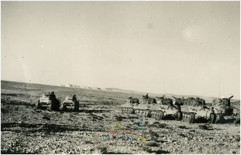
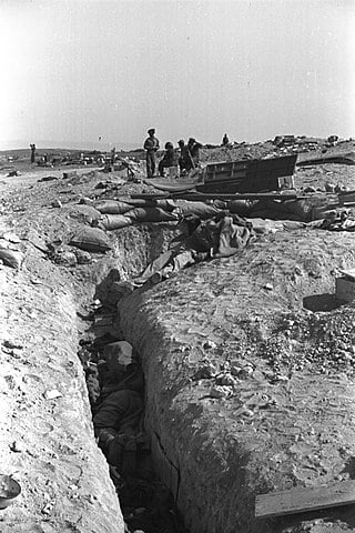
Village Before NakbaThe village was situated in an area of rolling hills on the coastal plain. It stood on the east bank of a wadi, immediately to the west of the Gaza–Julis highway, which ran parallel to the main coastal highway. Secondary roads linked it to a number of surrounding villages. In the late nineteenth century, Hulayqat was a small village on a gentle slope, flanked by a high sandy hill and a garden to the west. The village, which expanded toward the end of the Mandate, was rectangular in shape, with the long side of the rectangle extending along the highway. Its adobe houses stood close together and were interspersed with some small shops. The villagers were Muslims, and they obtained their domestic water from two wells inside the village. They worked mainly in rainfed agriculture, growing grain and fruit. Fruit cultivation was concentrated in the northwestern lands. In 1944/45 a total of 6,636 dunums was allotted to cereals; 115 dunums were irrigated or used for orchards. In addition to agriculture, people worked with the British-Iraq Petroleum Company after it began exploring the region for oil. Close to Hulayqat lay several khirbas that contained cisterns, a pool, and fragments of marble and pottery.Village Occupation and Ethnic CleaningThe History of the Haganah states that when the Palmach's Negev Brigade destroyed the village of Burayr, 'the peasants from the adjacent villages of Huleiqat and Kawkaba began to flee in the direction of the Hebron hills.' This occurred on 13 May 1948, during Operation Barak . The Palmach established a position in the village. But Egyptian writer Muhammad Abd al-Mun'im states that Hulayqat was recaptured by Egyptian forces on 8 July, just before the first truce of the war expired. Egyptian armored vehicles took the village in a surprise attack from the north and held onto it until the second truce. Abd al-Mun'im states that the operation was in response to encroachment by Zionist forces in the area.Some villagers apparently remained throughout the second truce, when heavy fighting between Egyptian and Israeli forces led to another exodus. Hulayqat was reoccupied on 19–20 October, the History of the War of Independence relates, in a two-pronged attack from Bayt Tima in the northwest and Kawkaba in the north. The battle between the Giv'ati Brigade and Egyptian forces involved combat at close quarters in some places. Israeli historian Benny Morris insists: 'There had been no expulsions; the locals had simply fled in face of the approaching hostilities.' On 20 October, the New York Times correspondent wrote that Hulayqat, 'the most southerly point held by the Egyptians in the desert proper, fell last night after the heaviest battle of the campaign….' The village was defended by 600 Egyptian regulars; around 100 of them were killed and a similar number taken prisoner, according to the Times. Egyptian writer Abd al-Mun'im adds that with the occupation of Hulayqat, 'the enemy was able to open a road to his southern settlements and became a dangerous threat to our forces.' Zionists Colonies on Village LandsThere are no Israeli settlements on village lands.Village TodayThe site is partially forested. There are sycamore and Christ's-thorn trees and cactuses growing on the site. One of the old roads has been covered by a modern street.SourceDr. Walid al-Khalidi, 1992: All That Remains. |
|||||||||||||
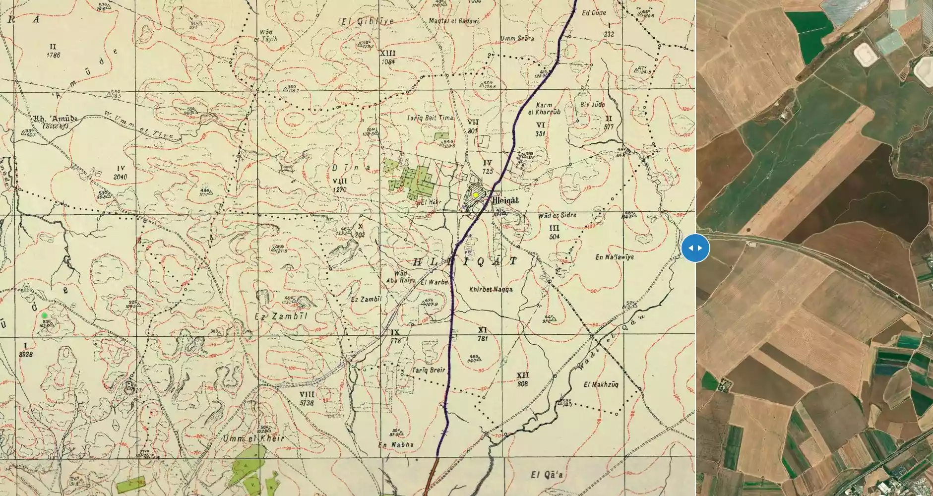
| Related Maps | Town Lands' Demarcation Maps خرائط للقضاء توضح حدود القرى والاودية Town's map on MapQuest View from satellite Help us map this town at WikiMapia |
||||||||||||
| Related Links | Wikipedia's Page Google Search Google For Images Google For Videos |
||||||||||||
| More Information | في كتاب كي لا ننسى في كتاب بلادنا فلسطين المزيد من موقع هوية |
||||||||||||
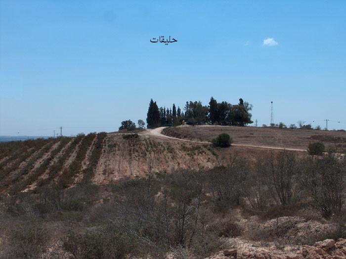
- منظر عام لموقع القرية المدمرة
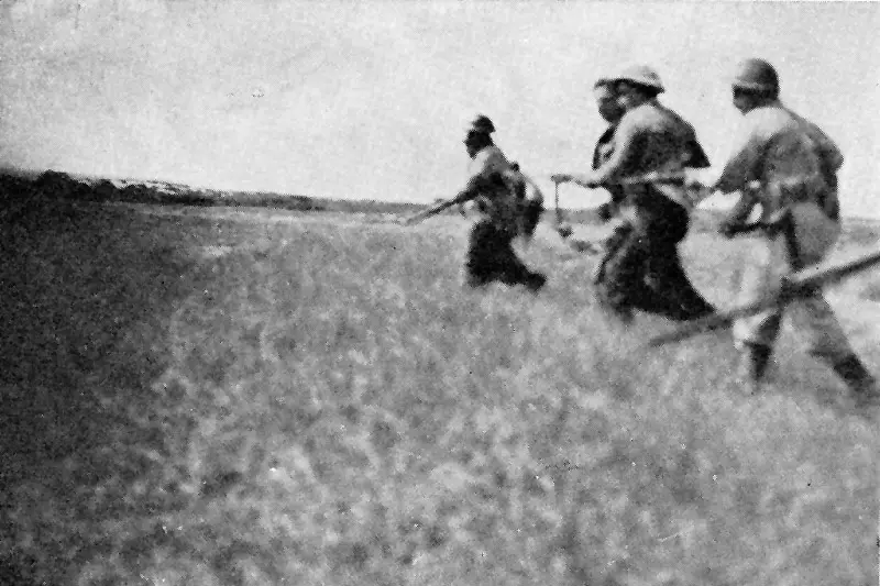
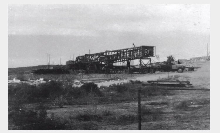
Posted by محمد ألأعسم 9 - لحظة الهجوم الصهيوني على حليقات - المصدر: موقع لواء غفعاتي الصهيوني
Posted by M. S. - قريه حليقات قبل النكبه
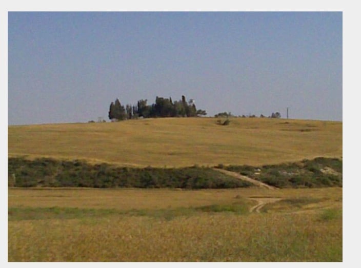
Posted by abu raya - موقع القريه
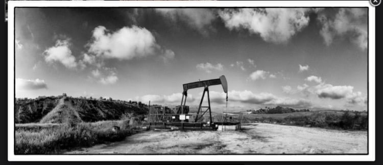
Posted by abu raya - خطوط النفط في حليقات
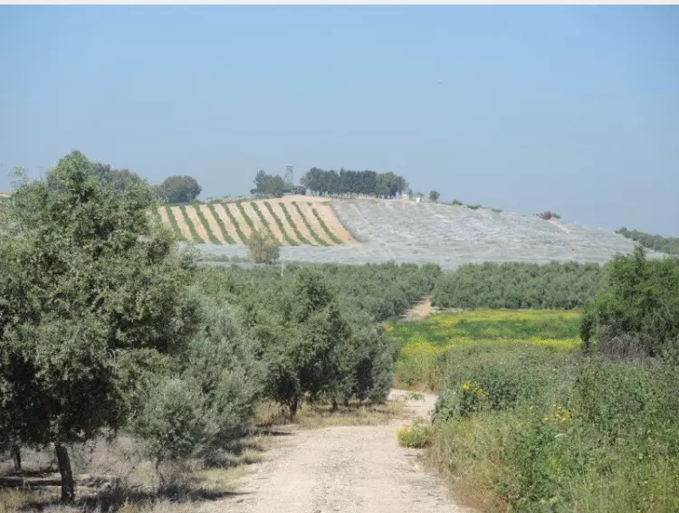
Posted by abu raya - موقع واراضي القريه
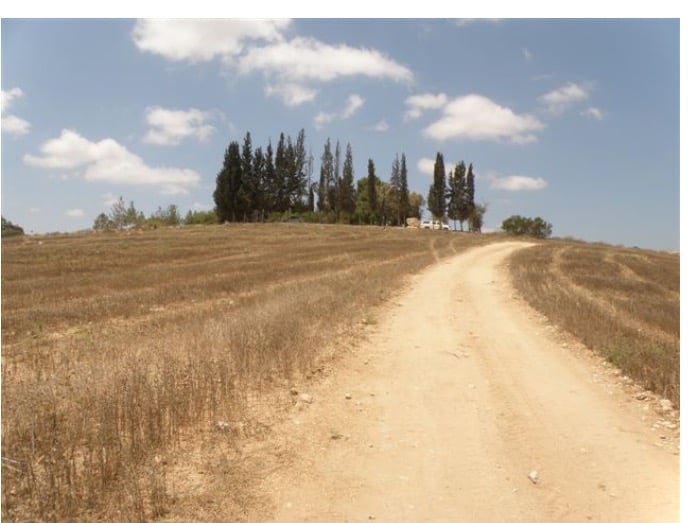
Posted by abu raya - موقع القريه
Posted by abu raya - خطوط النفط في القريه
Posted by abu raya - الحليقات بعد الإحتلال 1948
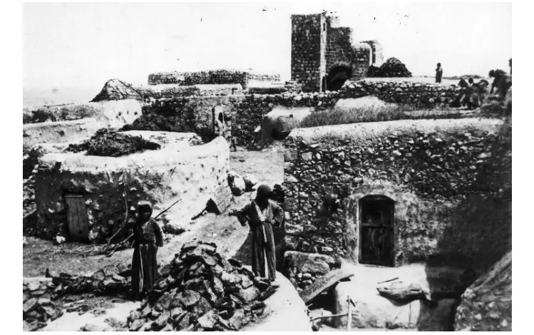
Posted by أبو اليزن السعافين - شهداء الجيش المصري في الخنادق في الحليقات بعد الإحتلال 1948
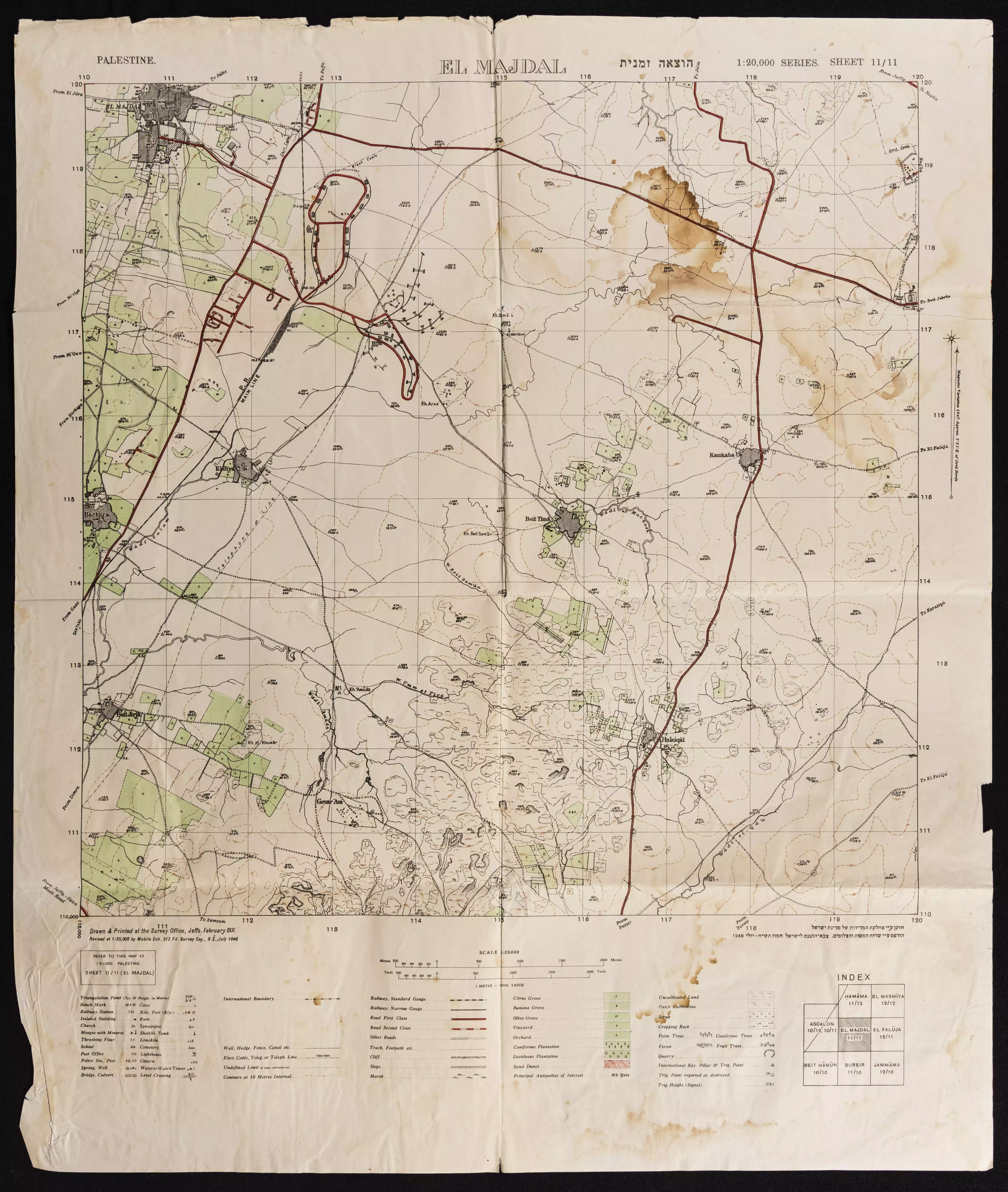
Posted by أبو اليزن السعافين - خارطة تُظهِر الحدود والطرق بأنواعها والأماكن المقدسة والطبيعة الطوبغرافية من تلال وسهول ومنحدرات والتشكيلة الطبيعية للأرض وأنواع المزروعات. نُشرت الخريطة فترة الانتداب البريطاني، تم إضافة تعديلات عليها من قِبَل خدمة الخرائط والصور التابعة للقوات العسكرية الاسرائيلية فترة الأربعينيات.
Want to browse more? 80,000 pictures were grouped in these gallaries:
| Display Name | Clan/Hamolah | Country of Residence |
| حقي هو عودتي | - | فلسطين المحتلة, فلسطين المحتلة |
| محمود أحمد مصطفى رزق صالح | صالح | Palestin - Gaza - Rafah, حليقات |
| احمد87 | - | غزة, حليقات |
| أحمد مصطفى رزق صالح | رزق | الشابورة.Rafa7 |
| عبد الحميد خليل | صالح | طرابلس, ليبيا |
| فايز سليم صالح | صالح | الرياض, السعودية |
| محمود فايز صالح | صالح | الرياض, السعودية |
| علاء فايز صالح | حليقات | الشابورة, فلسطين |
| Usama Saleh | - | Riyadh, Saudi Arabia |
| وسام | خليل | دمشق |
| ABU HUSAM | SALAH | - |
| محمد صالح | - | غزة, فلسطين |
| Ayman abdallah khaleel | Khaleel | Amman, Jordan |
- برنامج ::#أهل_البلاد::"قرية حليقات الفلسطينية" من انتاج قناة القدس اليوم الفضايئة. Duration: 19 min 50 sec
 Fake Valor: Why Did Zionist Jews Hoist Nazis Flag on Their Ships in the 1930s?
What is new?
-
Facts About Oct. 7th Gaza Raid
-
Remined Us Please:: Who Did Rape Who? Palestinians Raped Israelis? Or, was the other way around?
-
When Prof. Edward Said was invited to debate Bibi Netanyahu in the 1980s, watch what happened!
-
Ezra Klein of the NY Times on the "Jewish Race".
-
Abusing Blood Libel!
-
Did Israeli Soldiers Activate The Hanniba Direective On Oct. 7th? You Be The Judge
-
Zionist FAQ: Isn't it true that Palestinians don't want peace? Palestinians never accepted the two-state solution
- Facts about Haavara (Transfer) Agreement between Ben-Gurion & Hitler
-
Haavara FAQs: Why Did Zionist Jews Hoist Nazis' Flags on Their Ships in the 1930s?
- Haavara FAQs: When Chaim Weizmann met FDR in mid-1943, why was he silent about rescuing European Jewry?
-
Dear ChatGPT: How did Palestinians resist Napoleon's invasion of their country in 1799?
-
Dear ChatGPT: Gaza had a vibrant Jewish community in the mid-17th century. What happened to them?
-
Dear ChatGPT: Why did the Jewish Agency suppress news of the Holocaust during WWII?
-
Video Playlist: Jews share their DNA tests to end the conflict for good.
-
A Tale of Two Conflicts: Examining the Definition of Genocide
-
Prof. Abraham Polak And The Suppressed History of the Khazars and European Jewry
-
How Ronald Reagan would have framed the genocide in Gaza if he were still alive?
-
Haavara FAQs: Let us do the math: how many German Jews did The Haavara Agreement save?
-
Zionist FAQs: The Hebron Massacre of 1929, "clearly proves" that Palestinians are antisemitic, how could you deny it?
-
Zionist FAQs: Why Anti-Zionist Is Not Antisemitism?
-
Zionist FAQs: Isn't it true that the KGB created Palestinian Nationalism in the early 1960s?
- Zionist FAQs: Muslims are killing Muslims all the time; why are Israeli Jews being singled out in the media?
- Zionist FAQs: How is Israel an apartheid state when 20% of its citizens are Arabs who enjoy full rights?
-
Haavara FAQs: Why Did Dorothy Thompson Flip From A Zionist Advocate to A Silenced Dissenter?
-
Haavara FAQs: Analysis of Herzl's Uganda Scheme and how it could have saved millions of Jews.
-
Haavara FAQs: Why did Hayim Greenberg describe American Jewry as "morally bankrupt" in early 1943?
-
Haavara FAQs: What if the Evian Conference was a resounding success? What would have been the impact of saving European Jewry on Zionism?
- Haavara FAQs: What if the six million were saved, how that would have impacted the Zionist project?
-
Haavara FAQs: How did Zionist leaders react when Europe's Jews lingered in the DP camps after WWII ended?
-
Why does the American Jewish community repeat lies that David Ben-Gurion had debunked before he died?
-
Who has the power to rename the Tatar/Khazar Gene Marker to Jewish IV?
-
Zionist FAQs: Why won't Egypt, Syria, and Jordan take their people back? Jews are indigenous to Palestine, and Arabs immigrated after Jews developed the country. Arabs should leave.
-
Haavara FAQs: Did Hitler and the Nazis conflate between Judaism and Zionist? If that wasn't case, then why?
-
Haavara FAQs: Winston Churchill and antisemitism, a collection of articles written Churchill.
-
Haavara FAQs: Broken by country, how many Jews survived vs. killed during the Holocaust?
-
Haavara FAQs: Why did European Jews vote with their feet and to immigrated to the Americas, not Palestine, after WWII?
-
Watch this American Jewish Girl describing Israeli Jews' cognitive dissonance like no other in under two minutes
-
Haavara FAQs: When the Nazis went out of their way to hide the Holocaust, Israeli Jews did the exact opposite by broadcasting their genocide of Gazans. But why?
-
Haavara FAQs: How Zionist Jews went out of their to show their appreciation to Nazism and Fascism?
- Haavara FAQs: Why Zionist leaders were against bombing the death camps & the Railroads leading to them?
-
Haavara FAQs: Hitler's message to the British and American people: If Jews are such noble citizens and you care about them, how come you're not letting them in? I will gladly ship them to you at my expense, even on luxury liners!
-
A shortlist of Zionist and Israeli false flag operations in the name Jews.
-
The Most Moral Army
- The Land of Kapos (Israel): Where the brave are boycotted and Kapos walk free.
- Why did early Zionists often named their communal enterprises "colonial"?
- Zionist Relations with Nazi Germany by Faris Glubb
-
Two NY Times advertisements by Zionists in the early 1943 that exposes Zionists' treason at the height of the calamity
- Facts Not Lies about the Palestinian-Israeli Conflict.
- Site's pictures have been categorized
- Campgain Against Lice
- A Survey of Palestine, the official source about Palestine before Nakba produced by the British Mandate; over 1200 pages.
- Satellite View & Google Earth: Over 6,000 placemarks identifying all destroyed towns, W. Bank & Gaza Strip Towns, & refugee camps.
- PalestineRemembered.com and its Nakba Oral History Project were featured on al-Jazeera Satellite TV.
- Nakba Oral History Video Podcast:
 Over 700 Oral History interviews (including 3,500+ hours of recording) can be viewed online.
 - Palestine Village Statistics Project
- Gaza Jail Break
- النسخة العربية للموقع الان متوفرة
- Videos: Documenting the destroyed villages in video: Tracing all that remains since Nakba.
- Videos: Responding to Zionist Propaganda
- Interview: The ethnic cleansing of Palestine: George Galloway interviews Israeli Historian Ilan Pappe.
- For Palestinians, memory matters. It provides a blueprint for their future By George Bisharat.
- Zionist FAQ now available in Hebrew שאלות שציונים שואלים, עכשיו בעברית
- Video: The Stephen Walt and John Mearsheimer report on the influence of the Israel Lobby on U.S. Foreign Policy
- The Palestinian-Israeli conflict for beginners
