| PalestineRemembered | About Us | Oral History | العربية | |
| Pictures | Zionist FAQs | Haavara | Maps | |
| Search |
| Camps |
| Districts |
| Acre |
| Baysan |
| Beersheba |
| Bethlehem |
| Gaza |
| Haifa |
| Hebron |
| Jaffa |
| Jericho |
| Jerusalem |
| Jinin |
| Nablus |
| Nazareth |
| Ramallah |
| al-Ramla |
| Safad |
| Tiberias |
| Tulkarm |
| Donate |
| Contact |
| Profile |
| Videos |
Welcome To Qira - قيرة وقامون (קירה וקאמון)
|
District of Haifa
Ethnically cleansed days ago |
العربية Google Earth |
 |
Gallery (9) |
- Statistics & Facts
-
Before & After

- Satellite View
- Articles 1
- Pictures 9
- Oral History 2
- Members 2
- All That Remains
- Wikipedia
- Videos
- Guest Book
- Links
| Statistic & Fact | Value | ||||||||||
| Occupation Date | March 1, 1948 | ||||||||||
| Distance From District | 23 (km) South East of Haifa | ||||||||||
| Elevation | 200 (meters) | ||||||||||
| Before & After Nakba, Click Map For Details |
|||||||||||
|
|||||||||||
| Map Location | See location #23 on the map View from satellite |
||||||||||
| Attacking Units | Terror campaign by a Haganah intelligence unit. | ||||||||||
| Exodus Cause | Haganah 'Wispering' campaign (psychological warfare) | ||||||||||
| Village Temains | The village has been completely obliterated with the exception of some house rubble. | ||||||||||
| Ethnically Cleansing |
In early March 1948, Qira and Qamun were both ethnically cleansed based on the the orders of Yosef Weitz (a JNF official), and soon after the houses and crops of these villages were destroyed to make sure that the inhabitants do not come back. |
||||||||||
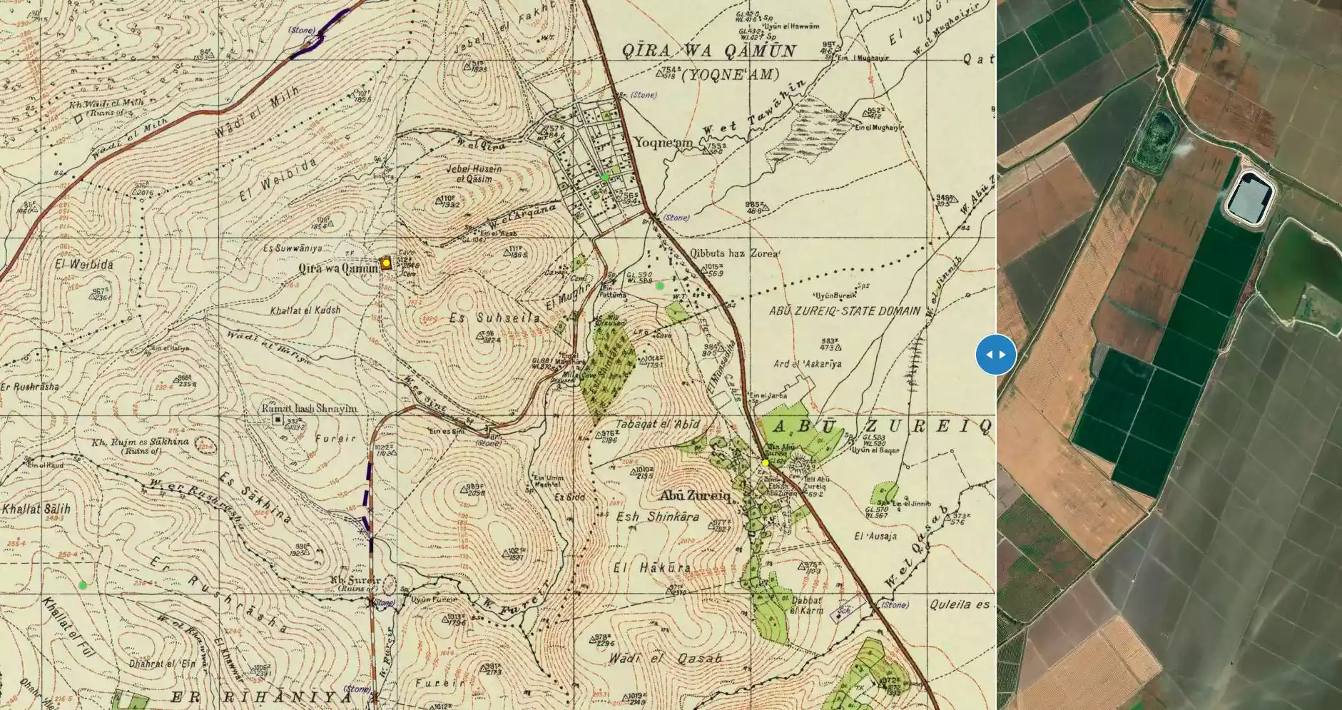
| Pre-Nakba Land Ownership |
**Town Lands' Demarcation Maps |
||||||||||
| Population |
|
||||||||||
| Number of Houses |
|
||||||||||
| Near By Towns |
|||||||||||
|
|||||||||||
| Town's Name Through History | The Canaanites referred to Qira by Yokneam, the Roman called it Cimona, and before occupation the village was known by Qira wa Qamun (closely related to the nearby village of Qamun). | ||||||||||
| Nearby Wadies & Rivers | The village was situated 6 km north of al-Muqatta' River. | ||||||||||
| Archeological Sites | Qira contained at least 19 archeological sites in its lands, and the most famous sites are Tel Qiri and Tel Qamun. | ||||||||||
| Exculsive Jewish Colonies Who Usurped Village Lands |
Yoqne'am, Yoqne'am 'Illit, & Kibbutz ha-Zore'a. | ||||||||||
| Featured Video | |||||||||||
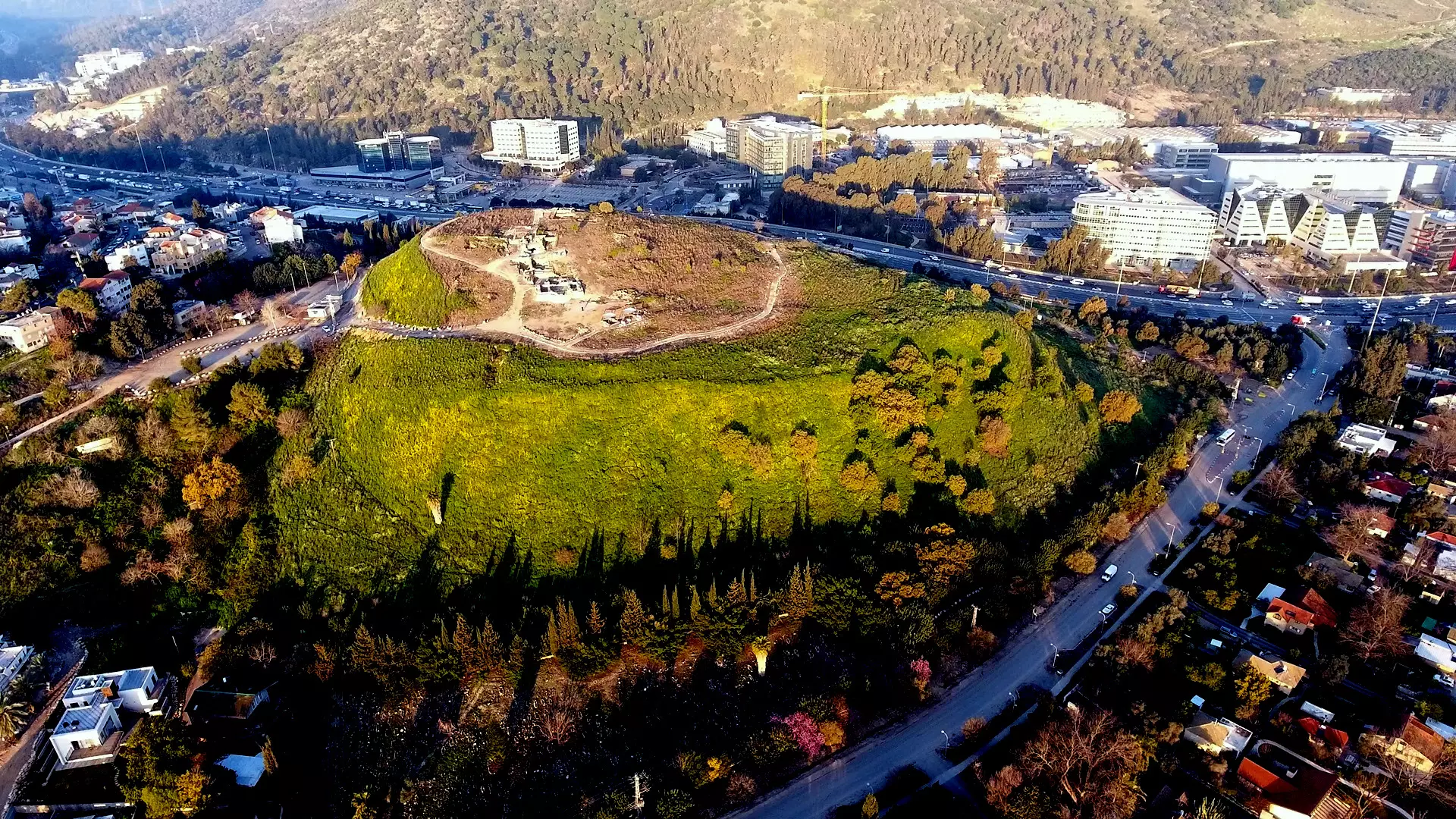
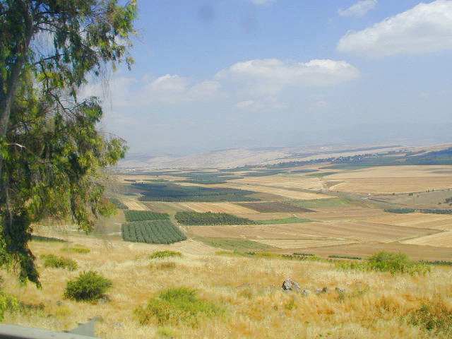
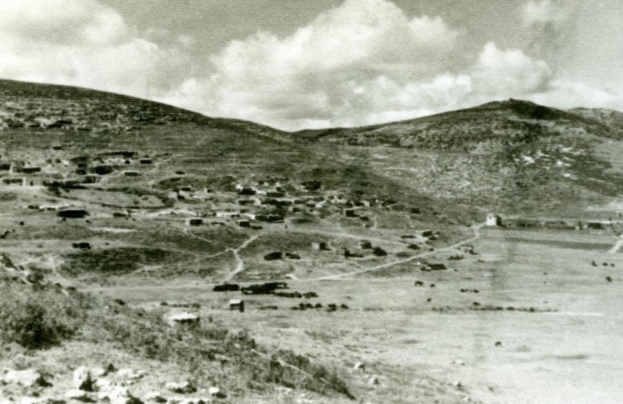
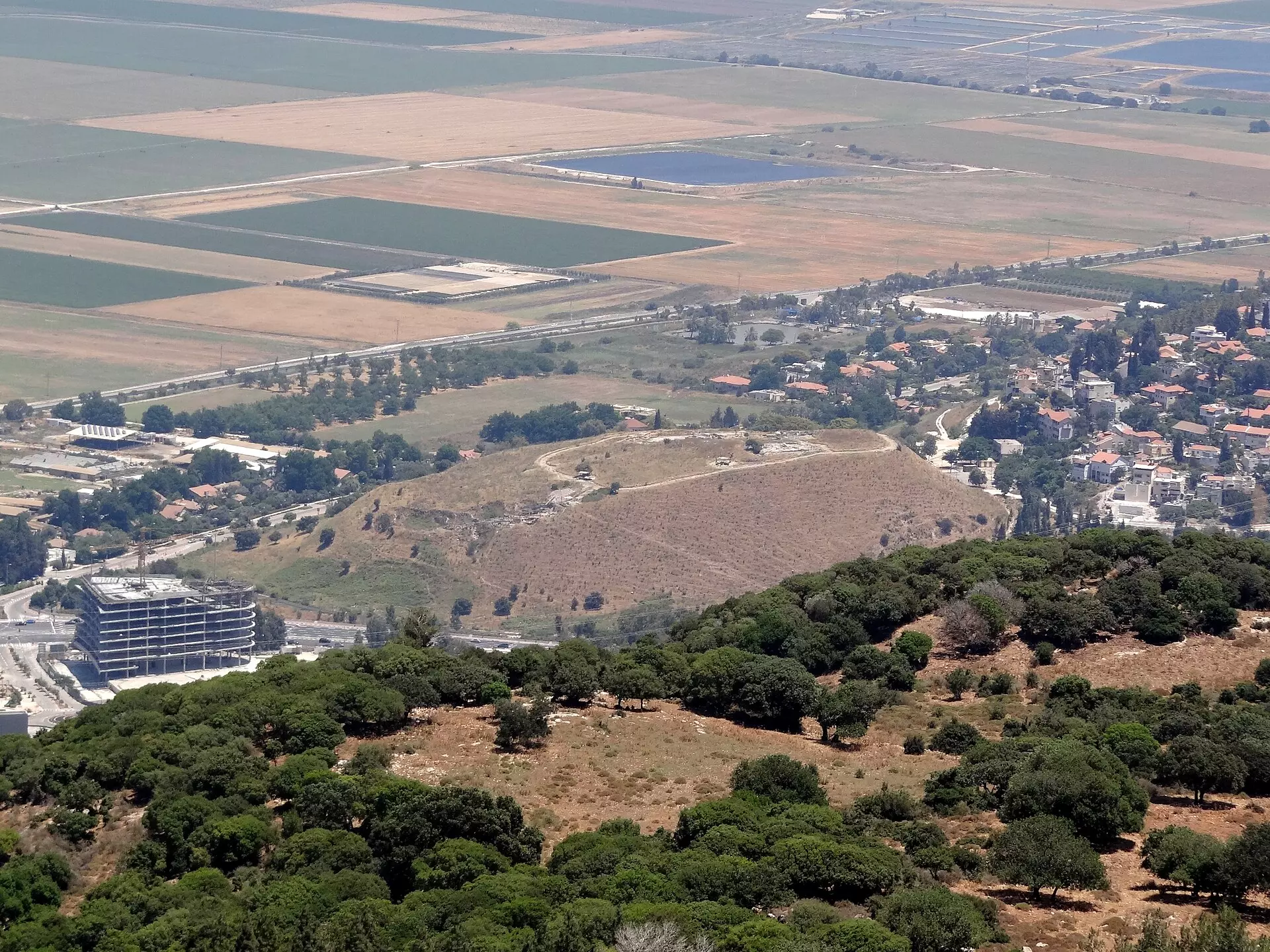
Village Before NakbaThe village was situated on the western, rocky bank of Wadi Qira and overlooked the plain of Marj ibn Amir. A closely related community, Tall Qamun , lay only 2 km to the northeast, and because the two were so closely associated, some people in the region spoke of them as 'Qira wa Qamun,' (Qira and Qamun). The al-Muqatta' River, which was 4 km to the north, formed the northern border of Qira's lands. Qamun was number 113 in the list of towns conquered by the Egyptian Pharaoh Thutmose Ill in 1468 B.C. It was probably the site of the royal Canaanite city of Yokneam, which fell to Joshua (Joshua 12:22), and the Roman city of Cimona. The Crusaders built the castle of Caymont on the tell where Qamun stood.Qira (wa Qamun), classified as a hamlet by the Mandate-era Palestine Index Gazetteer, had a square layout; its houses were made either of cement or of stone and mud. Bedouin pitched their tents in Qira during the sedentary months of their migratory cycle. Its population was Muslim, and it had several springs in various parts of its lands. Its agricultural economy was based on grain, which was planted on 261 dunums in 1944/45. The villagers also planted vegetables on small plots of land and earned extra income from livestock breeding. From the archaeological evidence on the surface of the site, it appears that Qira wa Qamun was built over an earlier settlement. Surveys of the region have produced evidence of at least nineteen archaeological sites in the area east of the village. The most important of these are Tall Qiri and Tall Qamun, both of which were excavated by the Hebrew University in Jerusalem. Village Occupation and Ethnic CleaningThe people of Qira wa Qamun were targeted for eviction by the Jewish National Fund (JNF) in March 1948, on the grounds that they were tenant farmers working on Jewish owned lands. A top official in the JNF's Lands Department, Yosef Weitz, told a Haganah intelligence officer to 'advise' the inhabitants of the village to leave. When they did, Weitz and other officials in the JNF decided to raze their homes and destroy their crops, later offering them compensation for the losses. Israeli historian Benny Morris says that this took place in late March, but says nothing about the destination of the villagers or the fate of the village lands.Zionists Colonies on Village LandsThe settlement of Yoqne'am was established in 1935 on what were traditionally village lands, northeast of the village site. By 1945, the settlers owned all the lands of the village. An extension of the settlement, Yoqne'am 'Illit, was established in 1950. Kibbutz ha-Zore'a was established in 1936 on the border between Qira wa Qamun's lands and those of Abu Zurayq.Village TodayRubble from village homes can be seen among the bushes and pine trees that have been planted on the village site. A spring still flows through a rock-cut channel. The area around it has been turned into an Israeli park. Almond, pomegranate, and fig trees grow on the site, and pine trees cover the hilly lands surrounding it. The other lands are planted in grain.Related Places SourceDr. Walid al-Khalidi, 1992: All That Remains. |
|||||||||||
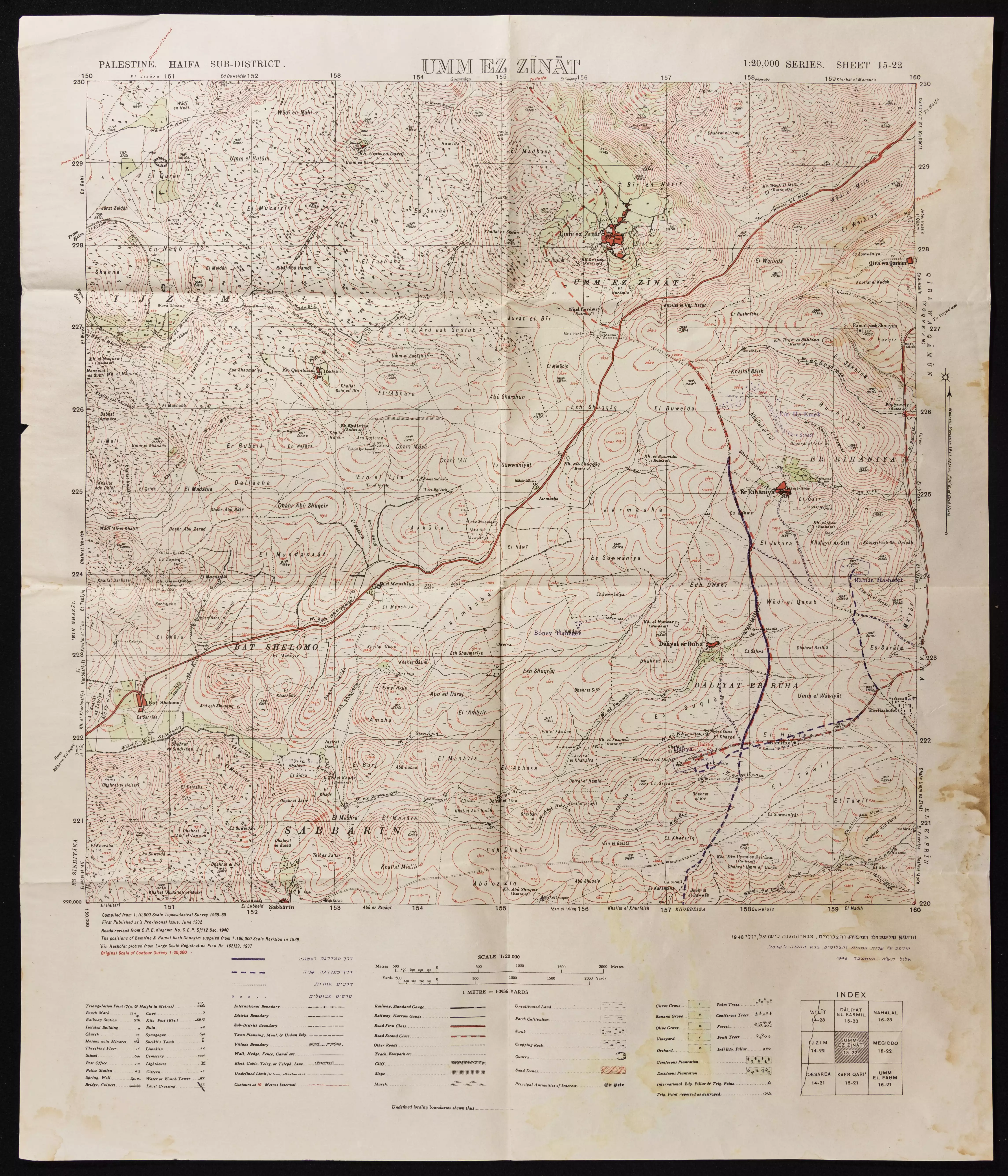
| Related Maps | Town Lands' Demarcation Maps خرائط للقضاء توضح حدود القرى والاودية Town's map on MapQuest View from satellite Help us map this town at WikiMapia |
||||||||||
| Related Links | Wikipedia's Page Google Search Google For Images Google For Videos |
||||||||||
| More Information | في كتاب كي لا ننسى في كتاب بلادنا فلسطين المزيد من موقع هوية |
||||||||||
- A view of Qira's land, 2000
Posted by Nur al-Irani 10 - صورة نادرة للقرية قيرة 1935
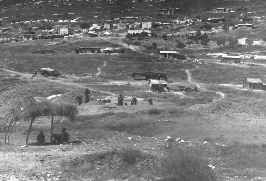
Posted by احمد فحماوي - منظر عام للمنطقة وللقرية عام 1935
Posted by احمد فحماوي - A view where the village used to stand. As you see, the most "civilized" obliterated the village. That is exactly how the Jews will be great again!
- الموقع الاثري الموجودة على التلة ويحتوي على بقايا كنيسة صليبية
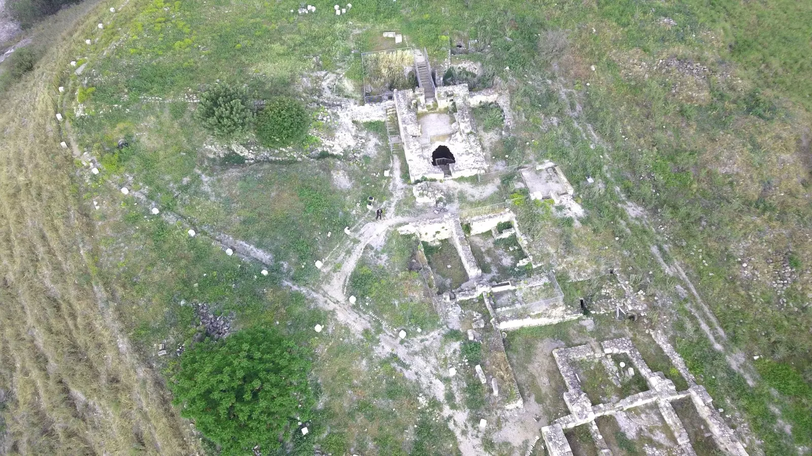
- الموقع الاثري الموجودة على التلة ويحتوي على بقايا كنيسة صليبية
#2
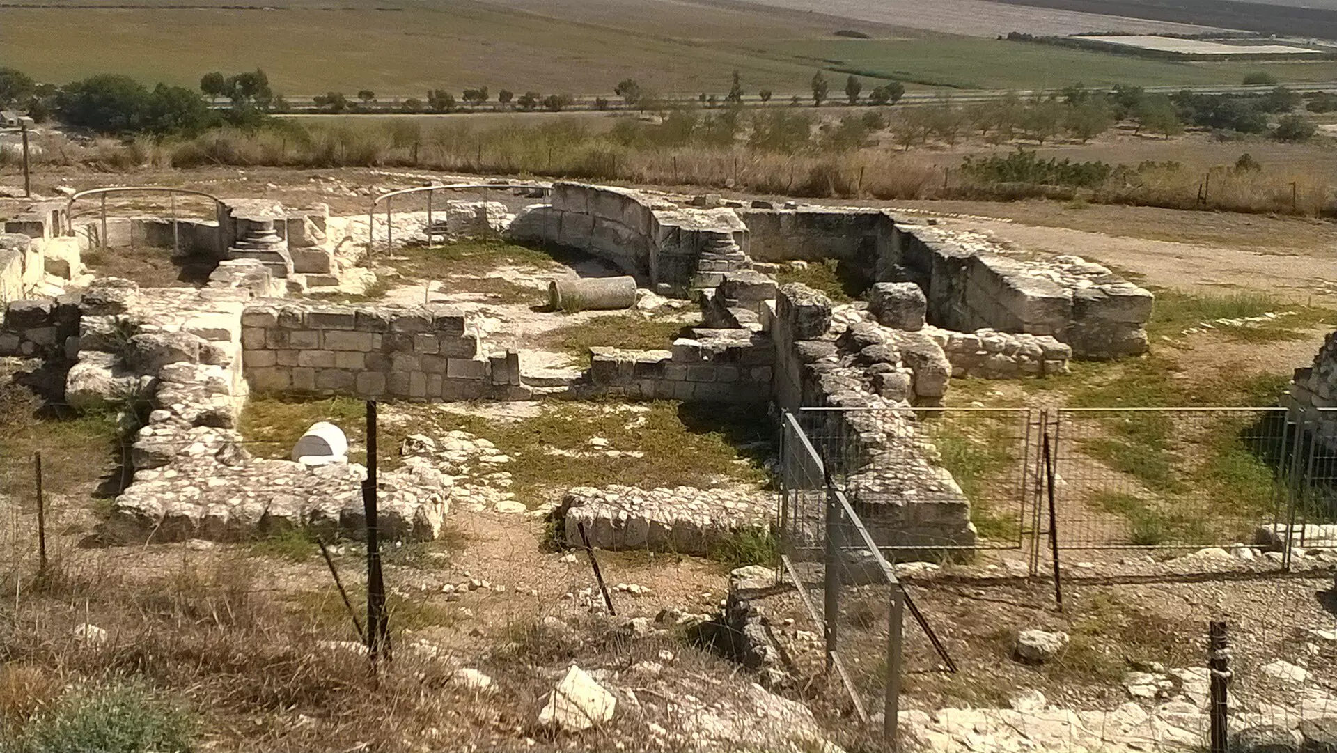
- الموقع الاثري الموجودة على التلة ويحتوي على بقايا كنيسة صليبية
#3
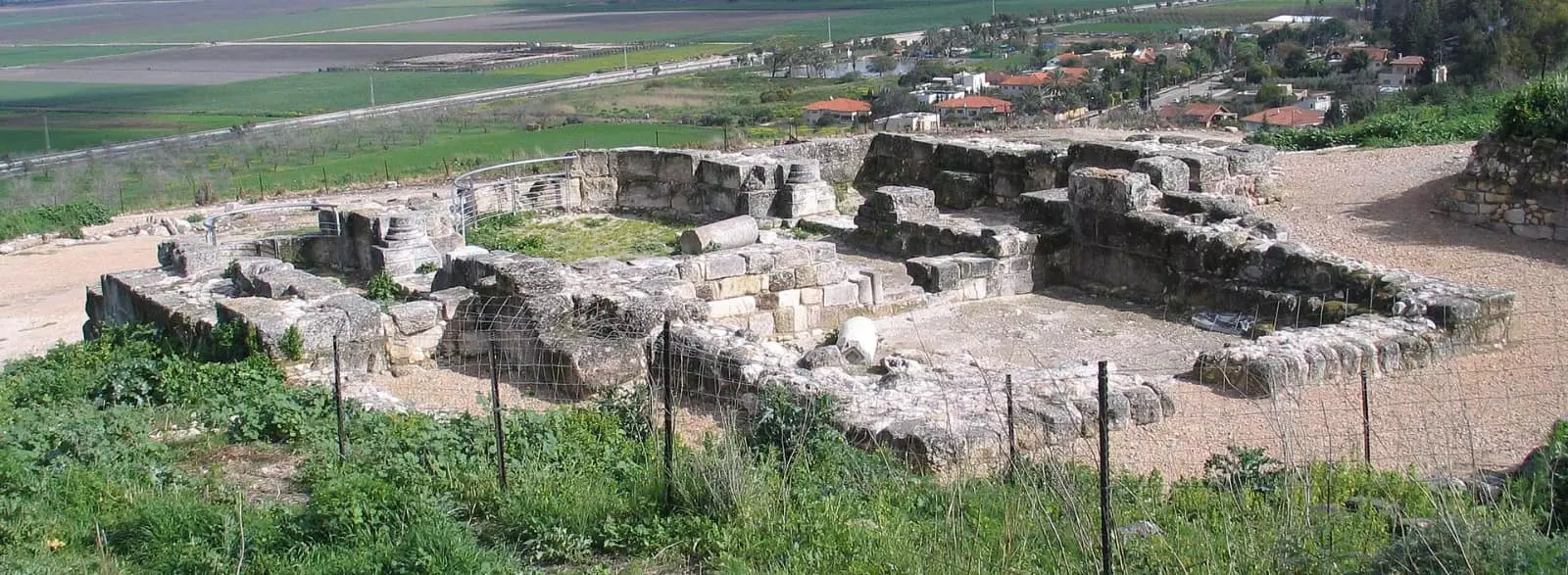
- الموقع الاثري الموجودة على التلة ويحتوي على بقايا كنيسة صليبية #4
- خارطة تُظهِر الحدود والطرق بأنواعها والأماكن المقدسة والطبيعة الطوبغرافية من تلال وسهول ومنحدرات والتشكيلة الطبيعية للأرض وأنواع المزروعات. نُشرت الخريطة فترة الانتداب البريطاني، تم إضافة تعديلات عليها من قِبَل خدمة الخرائط والصور التابعة للقوات العسكرية الاسرائيلية فترة الأربعينيات.
Want to browse more? 80,000 pictures were grouped in these gallaries:
| Display Name | Clan/Hamolah | Country of Residence |
| بيسان | - | الاردن |
| حمزة الجنيدي | الجنيدي | الاردن, الاردن |
No links have been shared yet, be free to the first to share the first link.
 Fake Valor: Why Did Zionist Jews Hoist Nazis Flag on Their Ships in the 1930s?
What is new?
-
Facts About Oct. 7th Gaza Raid
-
Remined Us Please: Who Did Rape Whom? Was it Palestinians who raped Israelis? Or, was the other way around? You'll be the judge
-
When Prof. Edward Said was invited to debate Bibi Netanyahu in the 1980s, watch what happened!
-
Ezra Klein of the NY Times on the "Jewish Race".
-
Abusing Blood Libel!
-
How and why Israeli Jewry has become the most hated cult?
-
Did Israeli Soldiers Activate The Hannibal Direective On Oct. 7th? You Be The Judge
-
Zionist FAQ: Isn't it true that Palestinians don't want peace? Palestinians never accepted the two-state solution
- Facts about Haavara (Transfer) Agreement between Ben-Gurion & Hitler
-
Haavara FAQs: Why Did Zionist Jews Hoist Nazis' Flags on Their Ships in the 1930s?
- Haavara FAQs: When Chaim Weizmann met FDR in mid-1943, why was he silent about rescuing European Jewry?
-
Dear ChatGPT: How did Palestinians resist Napoleon's invasion of their country in 1799?
-
Dear ChatGPT: Gaza had a vibrant Jewish community in the mid-17th century. What happened to them?
-
Dear ChatGPT: Why did the Jewish Agency suppress news of the Holocaust during WWII?
-
Video Playlist: Jews share their DNA tests to end the conflict for good.
-
A Tale of Two Conflicts: Examining the Definition of Genocide
-
Prof. Abraham Polak And The Suppressed History of the Khazars and European Jewry
-
How Ronald Reagan would have framed the genocide in Gaza if he were still alive?
-
Haavara FAQs: Let us do the math: how many German Jews did The Haavara Agreement save?
-
Zionist FAQs: The Hebron Massacre of 1929, "clearly proves" that Palestinians are antisemitic, how could you deny it?
-
Zionist FAQs: Why Anti-Zionist Is Not Antisemitism?
-
Zionist FAQs: Isn't it true that the KGB created Palestinian Nationalism in the early 1960s?
- Zionist FAQs: Muslims are killing Muslims all the time; why are Israeli Jews being singled out in the media?
- Zionist FAQs: How is Israel an apartheid state when 20% of its citizens are Arabs who enjoy full rights?
-
Haavara FAQs: Why Did Dorothy Thompson Flip From A Zionist Advocate to A Silenced Dissenter?
-
Haavara FAQs: Analysis of Herzl's Uganda Scheme and how it could have saved millions of Jews.
-
Haavara FAQs: Why did Hayim Greenberg describe American Jewry as "morally bankrupt" in early 1943?
-
Haavara FAQs: What if the Evian Conference was a resounding success? What would have been the impact of saving European Jewry on Zionism?
- Haavara FAQs: What if the six million were saved, how that would have impacted the Zionist project?
-
Haavara FAQs: How did Zionist leaders react when Europe's Jews lingered in the DP camps after WWII ended?
-
Why does the American Jewish community repeat lies that David Ben-Gurion had debunked before he died?
-
Who has the power to rename the Tatar/Khazar Gene Marker to Jewish IV?
-
Zionist FAQs: Why won't Egypt, Syria, and Jordan take their people back? Jews are indigenous to Palestine, and Arabs immigrated after Jews developed the country. Arabs should leave.
-
Haavara FAQs: Did Hitler and the Nazis conflate between Judaism and Zionist? If that wasn't case, then why?
-
Haavara FAQs: Winston Churchill and antisemitism, a collection of articles written Churchill.
-
Haavara FAQs: Broken by country, how many Jews survived vs. killed during the Holocaust?
-
Haavara FAQs: Why did European Jews vote with their feet and to immigrated to the Americas, not Palestine, after WWII?
-
Watch this American Jewish Girl describing Israeli Jews' cognitive dissonance like no other in under two minutes
-
Haavara FAQs: When the Nazis went out of their way to hide the Holocaust, Israeli Jews did the exact opposite by broadcasting their genocide of Gazans. But why?
-
Haavara FAQs: How Zionist Jews went out of their to show their appreciation to Nazism and Fascism?
- Haavara FAQs: Why Zionist leaders were against bombing the death camps & the Railroads leading to them?
-
Haavara FAQs: Hitler's message to the British and American people: If Jews are such noble citizens and you care about them, how come you're not letting them in? I will gladly ship them to you at my expense, even on luxury liners!
-
A shortlist of Zionist and Israeli false flag operations in the name Jews.
-
The Most Moral Army
- The Land of Kapos (Israel): Where the brave are boycotted and Kapos walk free.
- Why did early Zionists often named their communal enterprises "colonial"?
- Zionist Relations with Nazi Germany by Faris Glubb
-
Two NY Times advertisements by Zionists in the early 1943 that exposes Zionists' treason at the height of the calamity
- Facts Not Lies about the Palestinian-Israeli Conflict.
- Site's pictures have been categorized
- Campgain Against Lice
- A Survey of Palestine, the official source about Palestine before Nakba produced by the British Mandate; over 1200 pages.
- Satellite View & Google Earth: Over 6,000 placemarks identifying all destroyed towns, W. Bank & Gaza Strip Towns, & refugee camps.
- PalestineRemembered.com and its Nakba Oral History Project were featured on al-Jazeera Satellite TV.
- Nakba Oral History Video Podcast:
 Over 700 Oral History interviews (including 3,500+ hours of recording) can be viewed online.
 - Palestine Village Statistics Project
- Gaza Jail Break
- النسخة العربية للموقع الان متوفرة
- Videos: Documenting the destroyed villages in video: Tracing all that remains since Nakba.
- Videos: Responding to Zionist Propaganda
- Interview: The ethnic cleansing of Palestine: George Galloway interviews Israeli Historian Ilan Pappe.
- For Palestinians, memory matters. It provides a blueprint for their future By George Bisharat.
- Zionist FAQ now available in Hebrew שאלות שציונים שואלים, עכשיו בעברית
- Video: The Stephen Walt and John Mearsheimer report on the influence of the Israel Lobby on U.S. Foreign Policy
- The Palestinian-Israeli conflict for beginners
