| PalestineRemembered | About Us | Oral History | العربية | |
| Pictures | Zionist FAQs | Haavara | Maps | |
| Search |
| Camps |
| Districts |
| Acre |
| Baysan |
| Beersheba |
| Bethlehem |
| Gaza |
| Haifa |
| Hebron |
| Jaffa |
| Jericho |
| Jerusalem |
| Jinin |
| Nablus |
| Nazareth |
| Ramallah |
| al-Ramla |
| Safad |
| Tiberias |
| Tulkarm |
| Donate |
| Contact |
| Profile |
| Videos |
Welcome To al-Sammu'i - السموعي (א-סמועי)
|
District of Safad
Ethnically cleansed days ago |
العربية Google Earth |
 |
Gallery (35) |
- Statistics & Facts
-
Before & After

- Satellite View
- Articles 9
- Pictures 35
- Aerial Views 4
- Oral History 2
- Members 13
- Families
- All That Remains
- Town's Map
- Wikipedia
- Videos 2
- Guest Book 16
- Links
| Statistic & Fact | Value | ||||||||||||||||
| Occupation Date | May 12, 1948 | ||||||||||||||||
| Distance From District | 4 (km) West of Safad | ||||||||||||||||
| Elevation | 675 (meters) | ||||||||||||||||
| Before & After Nakba, Click Map For Details |
|||||||||||||||||
|
|||||||||||||||||
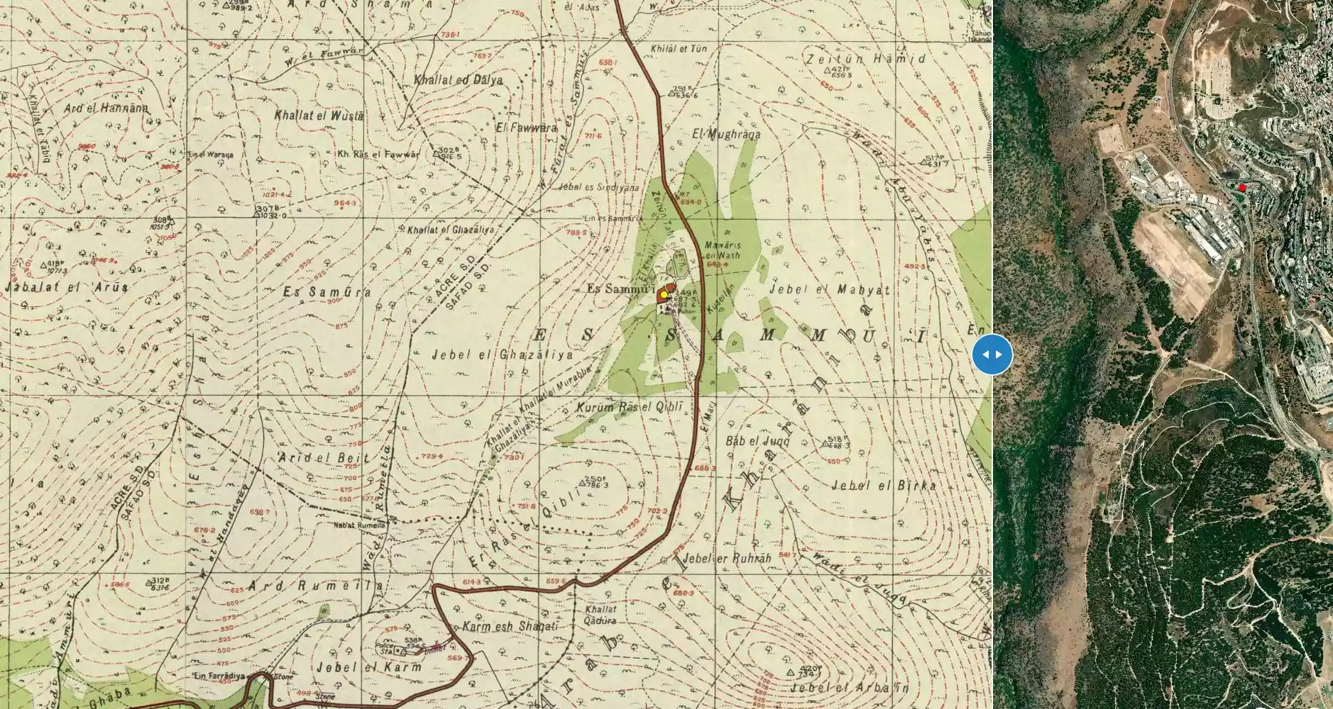
| Map Location | See location #68 on the map View from satellite |
||||||||||||||||
| Military Operation | Operation Hiram | ||||||||||||||||
| Exodus Cause | Influence of fall of, or exoduce from, neighboring town | ||||||||||||||||
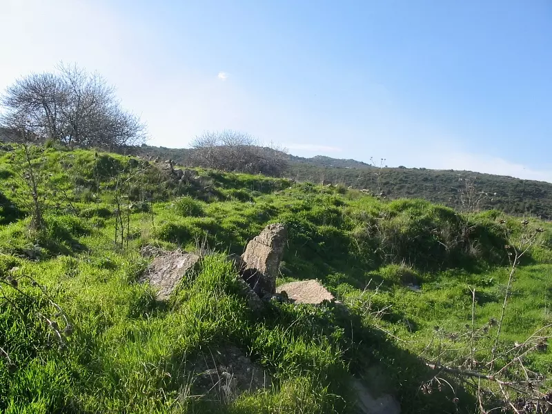
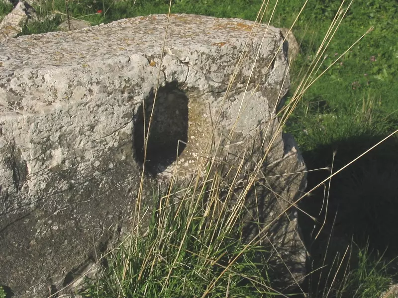
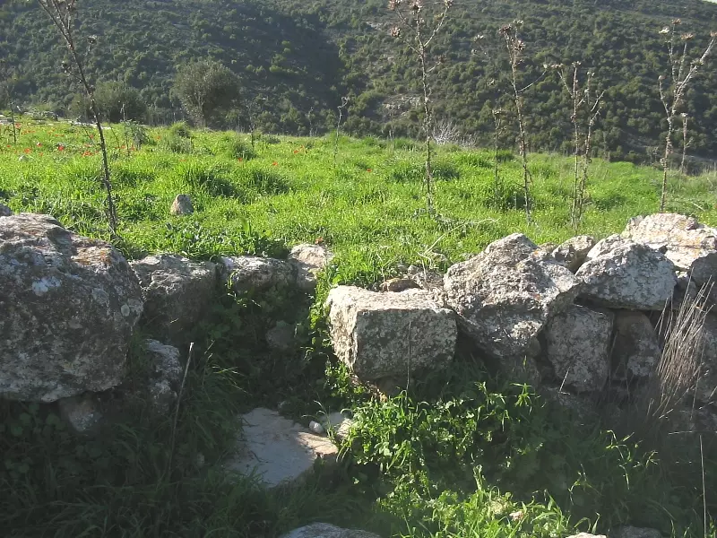
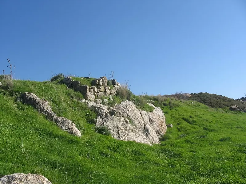
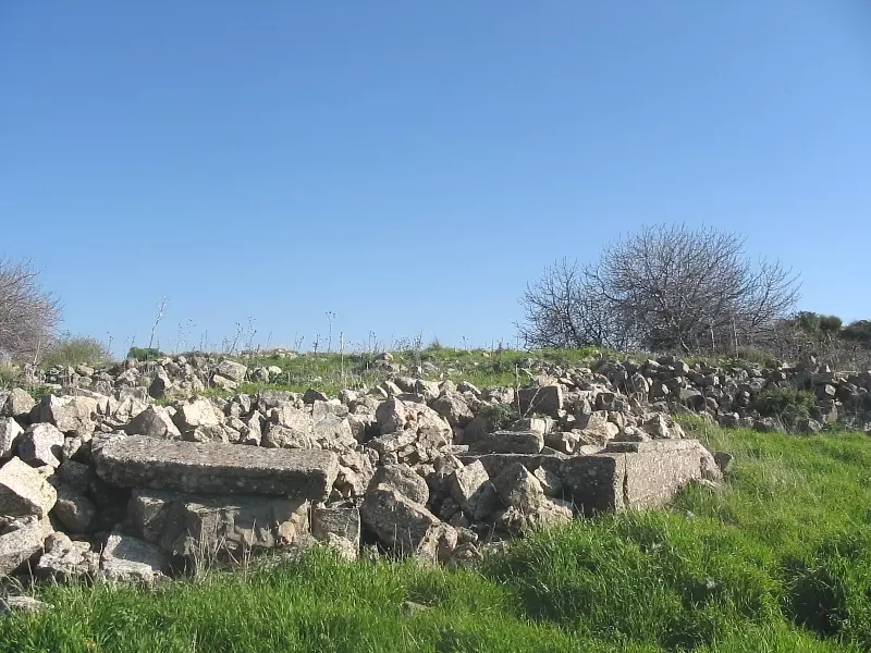
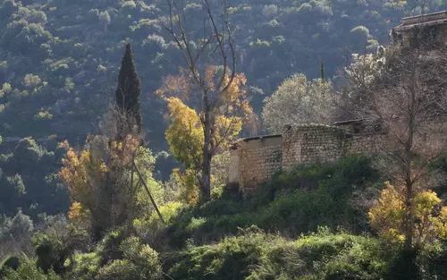
| Village Temains | The village has been completely destroyed, with the exception of some sections of stone walls, a well, and a canal | ||||||||||||||||
| Ethnically Cleansing | The village has been mostly ethnically cleansed on 12th of May 1948 | ||||||||||||||||
| Pre-Nakba Land Ownership |
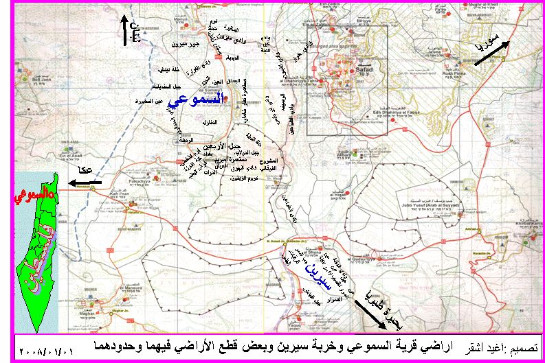
**Town Lands' Demarcation Maps |
||||||||||||||||
| Land Usage As of 1945 |
|
||||||||||||||||
| Population |
|
||||||||||||||||
| Number of Houses |
|
||||||||||||||||
| Near By Towns |
|||||||||||||||||
|
|
|||||||||||||||||
| Places of Warship | One mosque | ||||||||||||||||
| Shrines / Maqams | A shrine for a local sage known by al-Shaykh Muhammad al-'Ajami | ||||||||||||||||
| Nearby Wadies & Rivers | The village had number of springs terminated into a water tank | ||||||||||||||||
| Exculsive Jewish Colonies That Usurped Village Lands |
Kefar Shammay and Amirim | ||||||||||||||||
| Featured Video | |||||||||||||||||
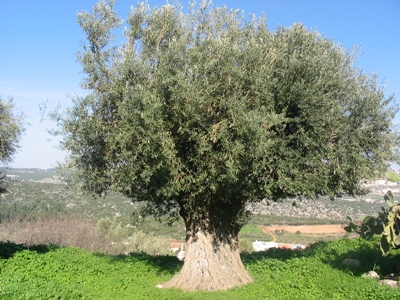
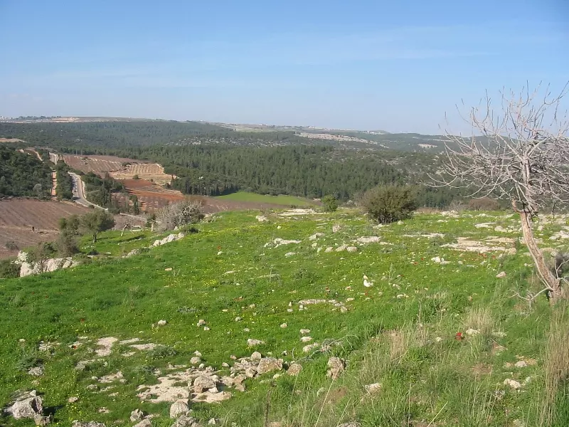
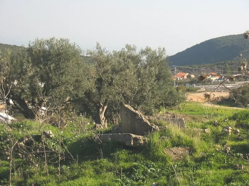
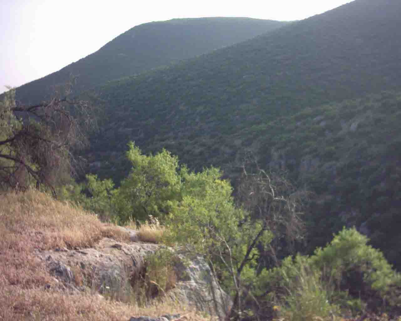
Village Before NakbaThe village stood on the eastern slope of Mount Zabud, and overlooked Safad to the east. It was about 100 m west of the Safad-Acre highway. In 1596, al-Sammu'i was a village in the nahiya of Jira (liwa' of Safad) with a population of 308. It paid taxes on a number of crops, including wheat, barley, and olives, as well as on other types of produce and property, such as goats, beehives, vineyards, and a press which was used for processing either olives or grapes. [Hut. and Abd.:177] The American biblical scholar Edward Robinson was told that al-Sammu'i lay on a 'comparatively level and easy' road when he passed through the region in the mid-nineteenth century. [Robinson 1856:72] Guérin, who saw the village in 1852, said that it was populated by 100 Muslims. When the authors of the Survey of Western Palestine reached the village, in 1877, it had 200 residents and was situated on a hill. There was a shrine for a Shaykh Muhammad al-'Ajami in the village as well as a number of cisterns. Many of al-Sammu'i's stone houses appeared to have been built of ancient materials. [SWP (1881) I:200,256]The outline of al-Sammu'i was a narrow rectangle. The 'Arab al-Madariba Bedouin pitched their tents southeast of the village every year when they passed by it in the course of their migratory cycle. Al-Sammu'i had a mosque―its population was predominantly Muslim―and a number of springs. One of them, on the north side, supplied drinking water, which was stored in three water tanks built by the villagers. Fruit and olive orchards were planted on the land south of the village; in the 1942/43 season 170 dunums were planted with olive trees. In 1944/45 a total of 4,204 dunums was allotted to cereals and 422 dunums were irrigated or used for orchards. Antiquities inspectors noted that there was a columned building in al-Sammu'i that was in ruins; this and other architectural fragments pointed to an earlier habitation of the site . Village Occupation and Ethnic CleaningIsraeli historian Benny Morris indicates that al-Sammu'i was wholly or partially evacuated in May 1948, but it was not occupied until October of that year. The initial flight, on 12 May, could have been caused by the fall of the city of Safad on the tenth of that month. This fact, together with the Haganah's psychological warfare campaign and mortaring of the villages in the area led to the exodus of many communities from the upper Galilee at this time. [M:123]At the end of October, al-Sammu'i fell within a pocket formed by converging units of the Israeli army during Operation Hiram (see 'Arab al-Samniyya, Acre sub-district). According to Morris, the village put up some resistance to the Israeli attack. As evidence, he cites the Israeli Minority Affairs Ministry's reference to al-Sammu'i as an example of a village which resisted and was therefore 'depopulated ―either by flight or by partial flight plus expulsion.' No further details are given. Zionists Colonies on Village LandsIsrael established the settlement of Kefar Shammay (193262) in 1949 on village lands,just to the east of the village site. Also on village lands, but further to the south, was the settlement of Amirim (192260), founded in 1950.Village TodayThe site is deserted. All that remains of the buildings are some sections of stone walls, a well, and a canal. A few olive and fig trees grow on the site, and the surrounding land is mostly used by Israeli farmers for grazing.SourceDr. Walid al-Khalidi, 1992: All That Remains. |
|||||||||||||||||
| Related Maps | Town Lands' Demarcation Maps خرائط للقضاء توضح حدود القرى والاودية Town's map on MapQuest View from satellite Help us map this town at WikiMapia |
||||||||||||||||
| Related Links | Wikipedia's Page Facebook Page Google Search Google For Images Google For Videos |
||||||||||||||||
| More Information | مخطط البلد في كتاب كي لا ننسى في كتاب بلادنا فلسطين المزيد من موقع هوية |
||||||||||||||||
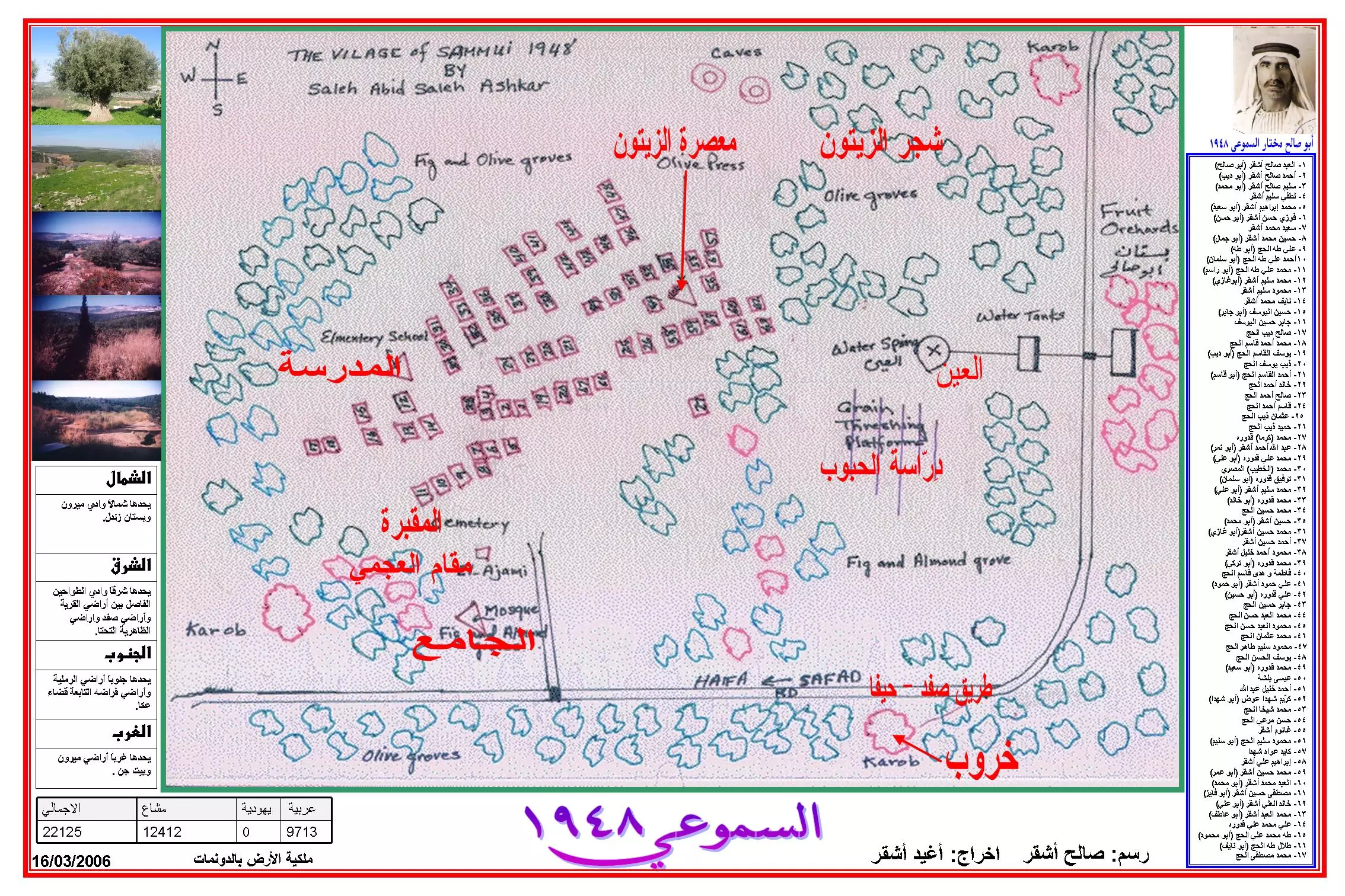
- مذكرات لقرية السموعي لمصلح الأشقر
- History of Al-Sammu'i as told by my grandparents .
- Map and family list available for uploading
- list of heads of families in Sammu'i - 1948 - accompanies the map
- *** الأرض الغائبة من الذاكرة**** سيرين
- إهداء وشكر إلى الأستاذ الدكتور حميد أحمد الحاج :بقلم محمـد ادغـيم
- نبذة تاريخية عن قرية السموعي (قضاء صفد) من كتاب (
كي لا ننسى ) - كتاب قرية السموعي بالإنجليزي
- Alsamoui book On English
- referance map, based on memories
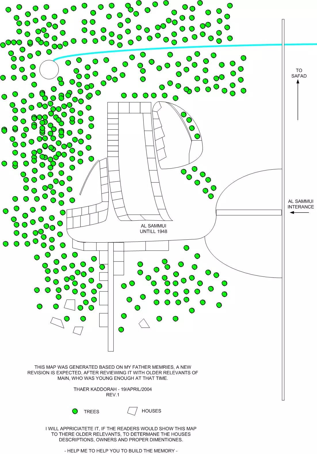
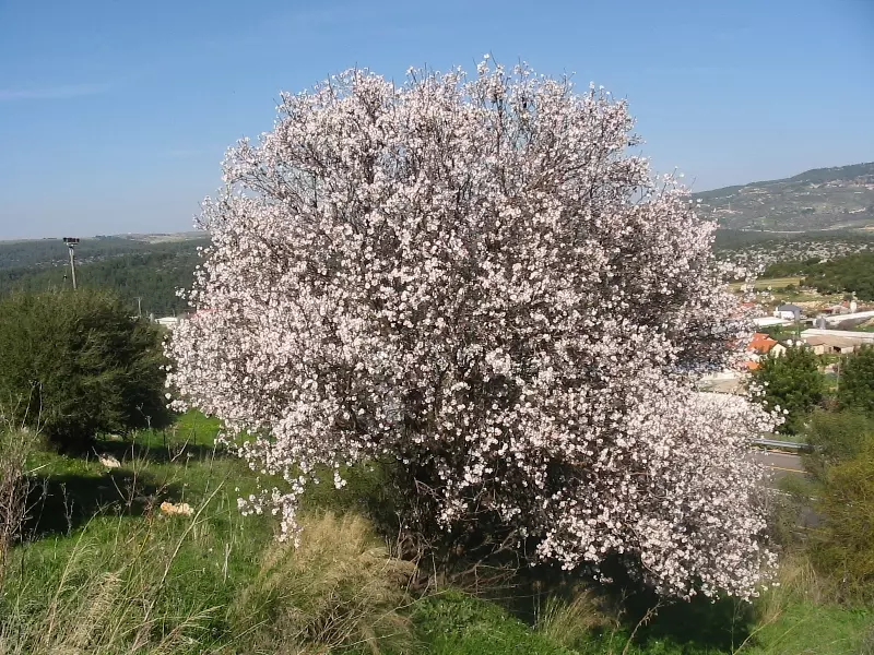
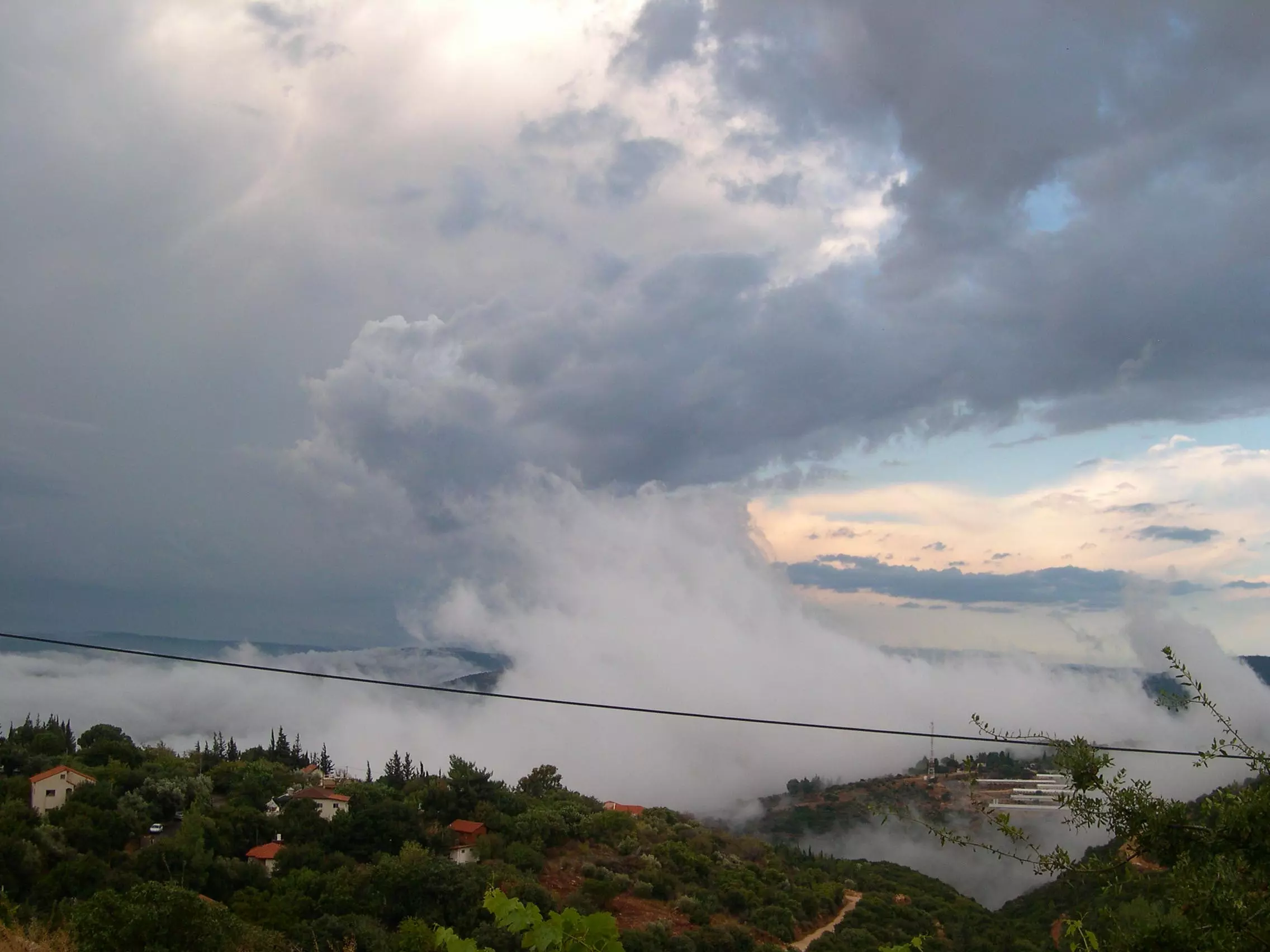
Posted by Thaer Kaddorah 1 - لوز السموعية , 28/2/2005 - تصوير مقبولة نصار
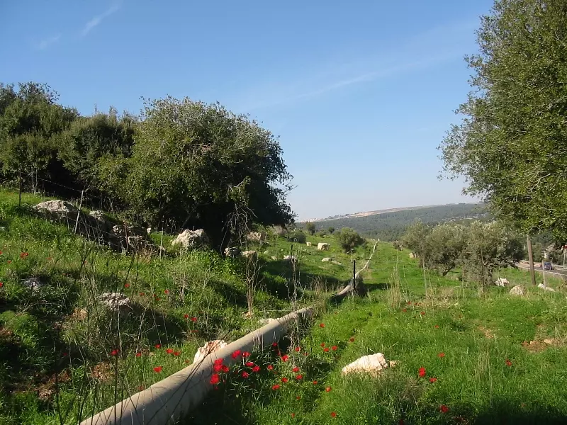
Posted by Makbula Nassar 1 - منظر عام محاذي لشارع صفد, 28/2/2005 - تصوير مقبولة نصار
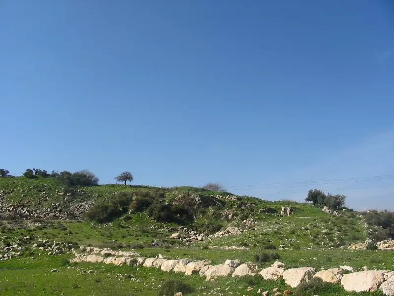
Posted by Makbula Nassar - التلة المقابلة تحوي اثار قليلة من القرية, الصورة من الجهة الجنوبية , 28/2/2005 - تصوير مقبولة نصار
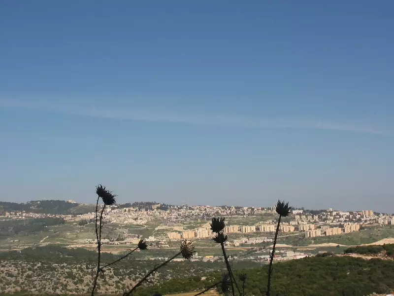
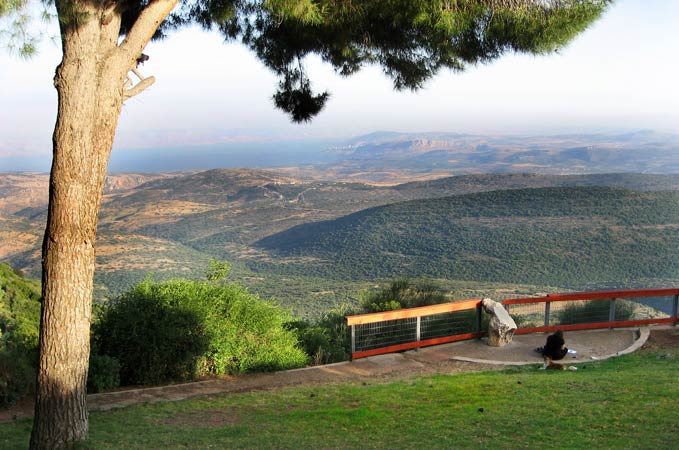
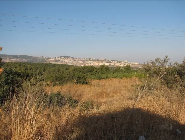
Posted by Makbula Nassar - مدينة صفد كما نراها من السموعية, 28/2/2005 - تصوير مقبولة نصار
Posted by Makbula Nassar - سنبقى ما بقي الزيتون - 22/2/2005 - تصوير مقبولة نصار
Posted by Makbula Nassar 1 - اطلال القرية, 28/2/2005 - تصوير مقبولة نصار
Posted by Makbula Nassar - اطلال القرية - 22/2/2005 - تصوير مقبولة نصار
Posted by Makbula Nassar - اطلال القرية, 28/2/2005 - تصوير مقبولة نصار
Posted by Makbula Nassar - اطلال القرية - 22/2/2005 - تصوير مقبولة نصار
Posted by Makbula Nassar - اطلال القرية, 28/2/2005 - تصوير مقبولة نصار
Posted by Makbula Nassar - اطلال القرية - 22/2/2005 - تصوير مقبولة نصار
Posted by Makbula Nassar - اطلال القرية, 28/2/2005 - تصوير مقبولة نصار
Posted by Makbula Nassar - map of Sammu'i in 1948 - drawn by a lifelong resident
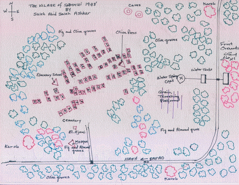
Posted by Saleh Al-Ashkar - خارطة السموعي وحدودها
Posted by Agiad Ashkar - خارطة توزيع المنازل ، أنقر الخارطة لتكبيرها - 1948
Posted by Agiad Ashkar 2 - جبل الأربعين التابع للسموعي جنوب القرية وجنوب طريق صفد عكا
Posted by Agiad Ashkar - جبل الأربعين جنوب القرية
Posted by Agiad Ashkar - بداية وادي الطواحين بين صفد واراضي السموعي (شرق السموعي) الطواحين كانت هنا فسمي وادي الطواحين
Posted by Agiad Ashkar - وادي الليمون وفي الأعلى جبل الدولاب وهو امتداد لجبل الأربعين المقامة عليه مستعمرة اميريم
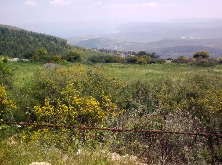
Posted by Agiad Ashkar - منظر من اراضي السموعي باتجاه صفد
Posted by abu raya - شمال القريه
Posted by abu raya - شرق القريه
Posted by abu raya - جنوب القريه
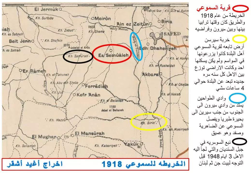
Posted by abu raya - قرية السموعي 1918
Posted by Agiad Ashkar - خارطة السموعي وأسماء الاوديه والاراضي فيها
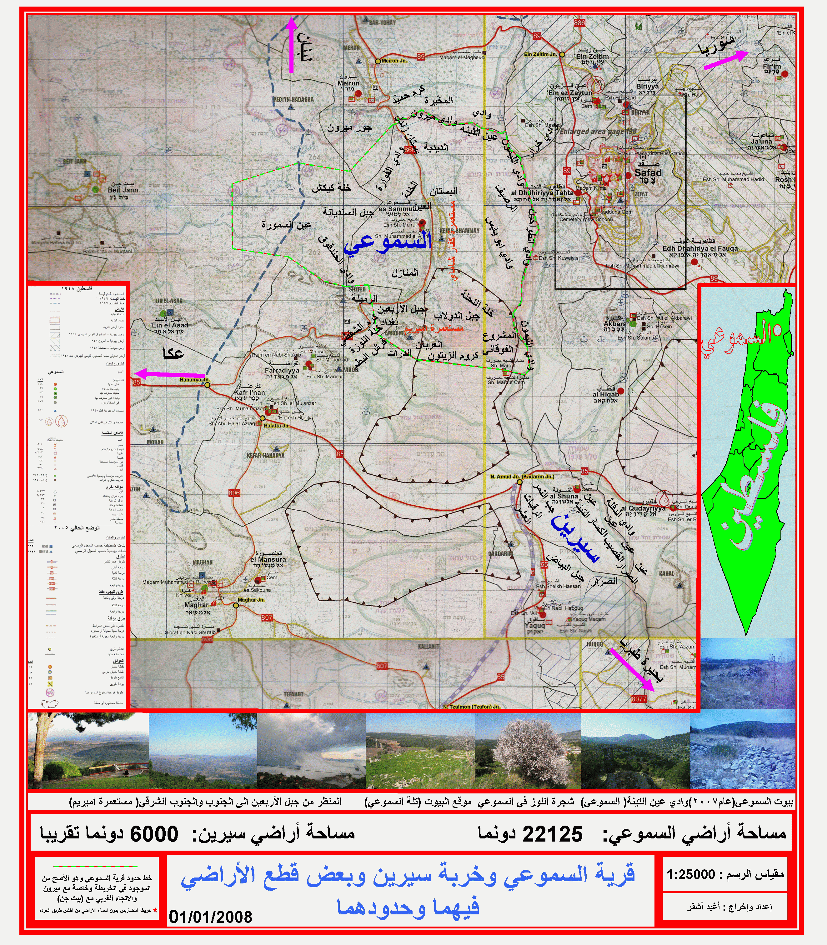
Posted by Agiad Ashkar - السموعي وخربة سيرين التابعه لأهالي السموعي

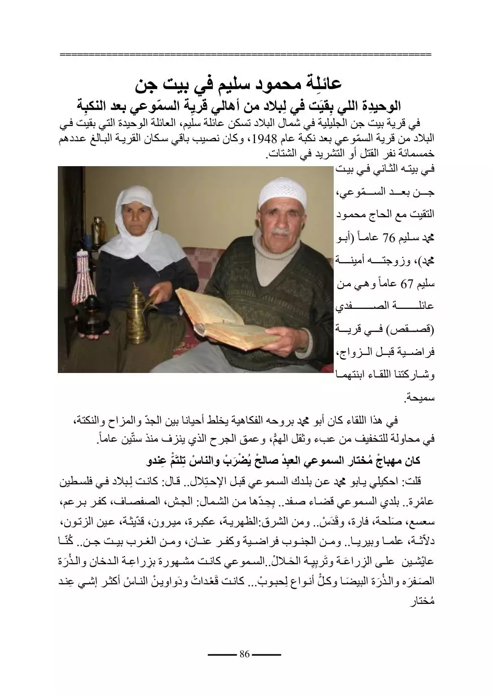
Posted by Agiad Ashkar - عائلة محمود سليم في بيت جن وهو الوحيد من الذين بقيوا في البلاد من اهالي قرية السموعي المهجرة
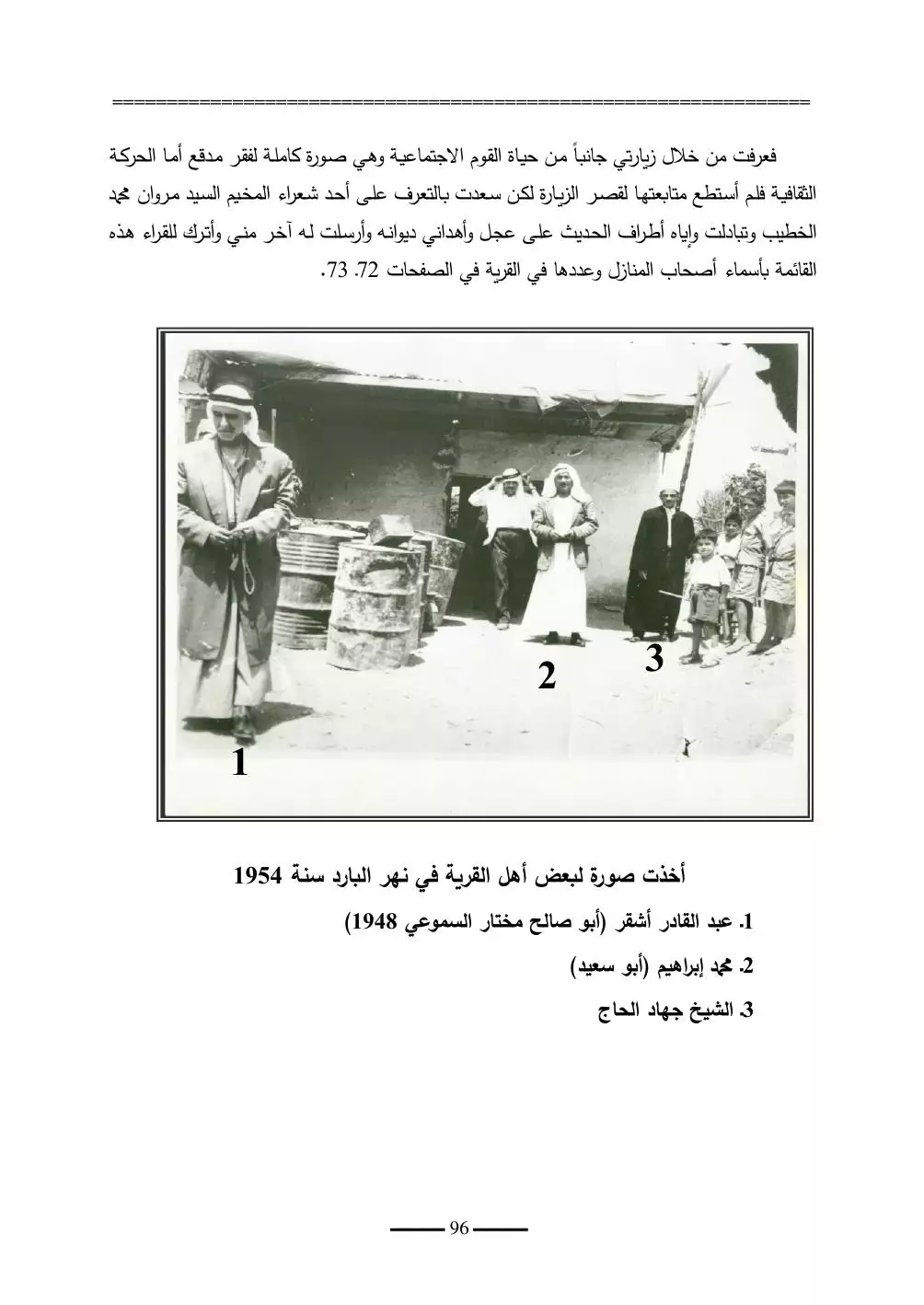
- صورة لبعض اهالي القرية في نهر البارد سنة 1954
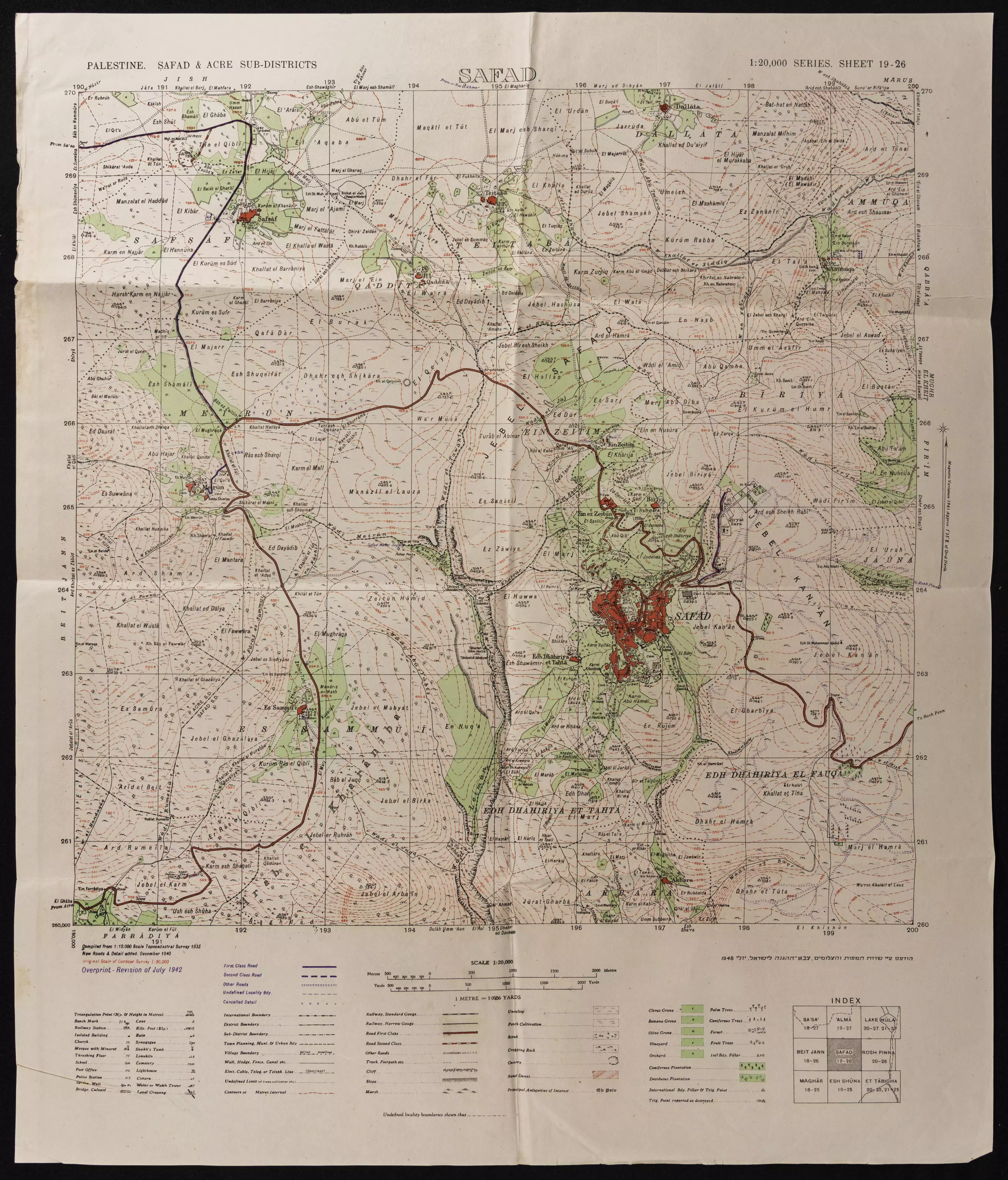
- خارطة تُظهِر الحدود والطرق بأنواعها والأماكن المقدسة والطبيعة الطوبغرافية من تلال وسهول ومنحدرات والتشكيلة الطبيعية للأرض وأنواع المزروعات. نُشرت الخريطة فترة الانتداب البريطاني، تم إضافة تعديلات عليها من قِبَل خدمة الخرائط والصور التابعة للقوات العسكرية الاسرائيلية فترة الأربعينيات.
-
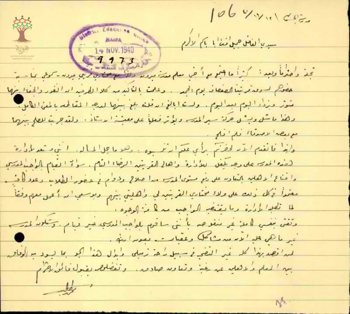
رسالة من المعلم محمد حمد -- من الصفصاف -- الى مفتش المعارف يطلب فيها تعيينه مديرا في مدرسة ميرون نظرا للخلافات بين مختاري قرية ميرون وقرية سموعي ما يؤثر على -- أداء المعلمين في المدرسة -- 14-11-1940
-
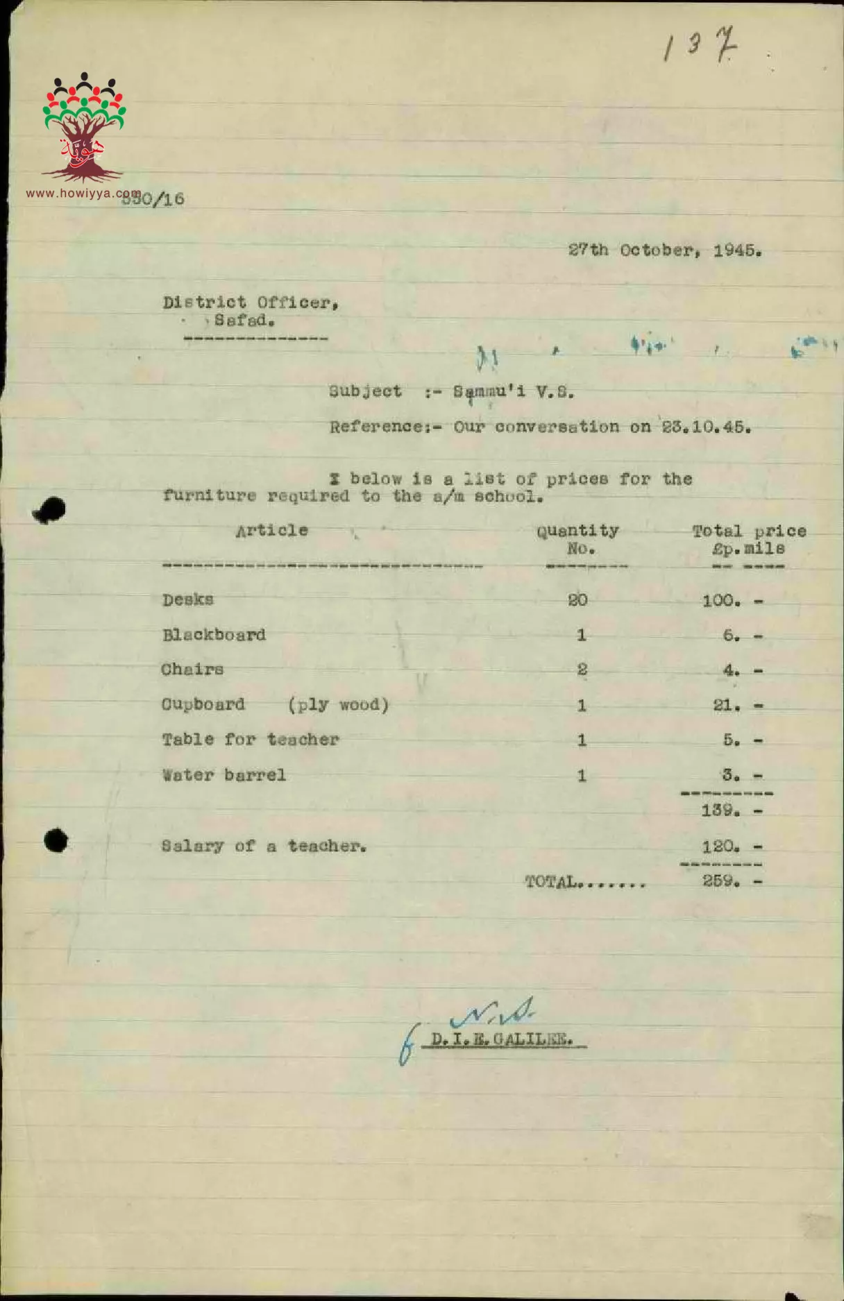
قائمة بأسعار الأثاث لمدرسة السموعي -- 26 -10-1945
-
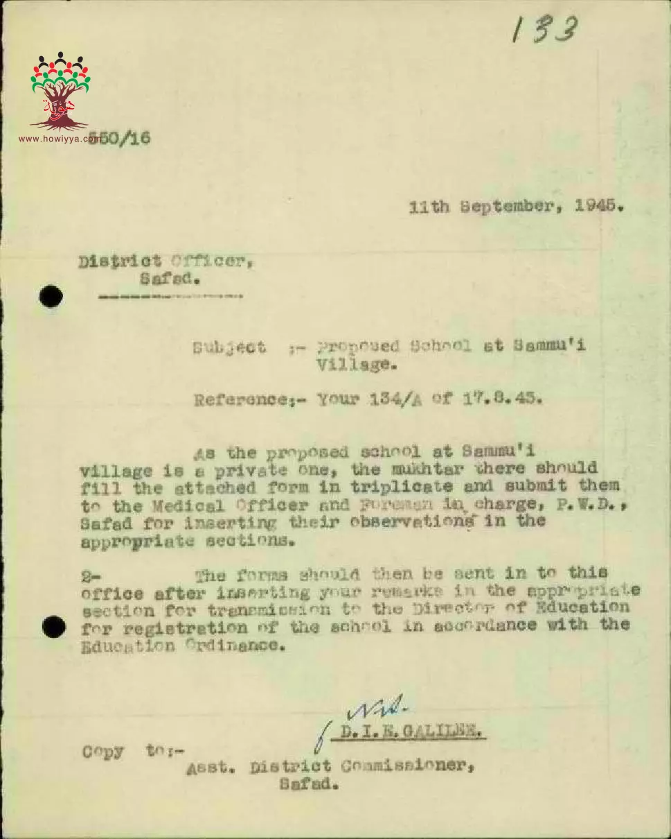
رسالة من مفتش المعارف الى مدير منطقة صفد بخصوص ضرورة تسجيل مدرسة قرية السموعي -- 11-09-1945
-
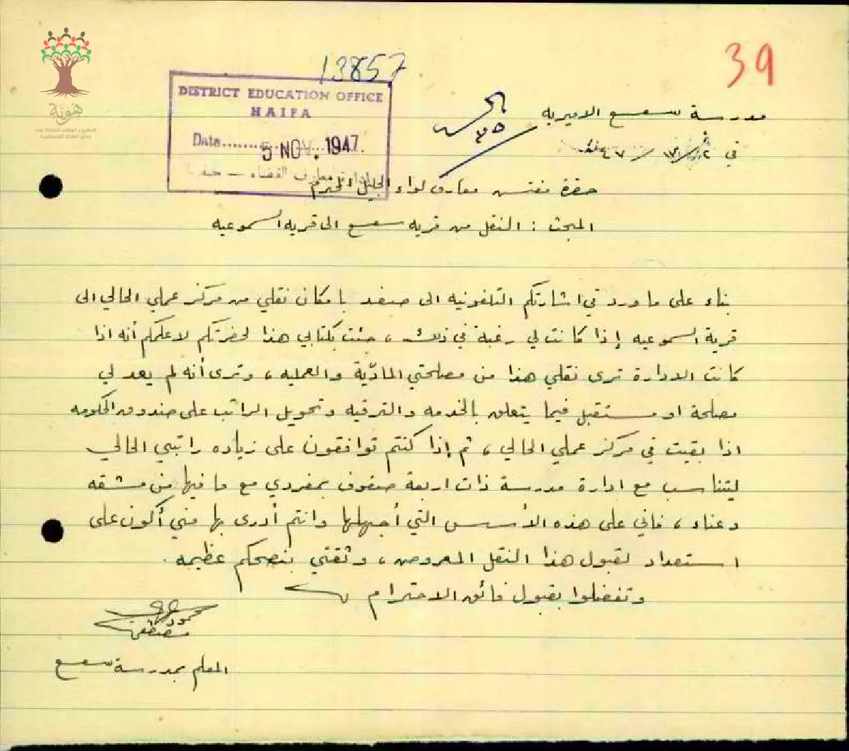
رسالة من المعلم مصطفى عرابي الى مفتش المعارف بناء على ورد في اشارتكم التنقلوني الى صفد بامكان نقلي من مركز عملي الحالي الى قرية السموعية --02-07-1947
-
شهادة من مختار السموعي لـ خليل حسن الذي هاجر الى الارجنتين ووالده حسن محمد الحسن من مواليد السموعي، ووالدته عمشة الحاج توفيت في السموعي وذلك ب شهادة المختار، اخوته: يوسف والعبد وعبد الله ومحمد الحسن. -- 02-04-1944
Want to browse more? 80,000 pictures were grouped in these gallaries:
| Display Name | Clan/Hamolah | Country of Residence |
| أنور ابو القآسم | - | Palestine |
| Nabeel Elhaj | - | - |
| abw kefah | - | السموعي, فلسطين |
| ابن السموعي من اليمن | - | مديرية يريم/مدينة كتاب, اليمن |
| ليلى مصطفى قدورة | قدورة | الرياض السعودية |
| أحمد حميد أحمد علي طه قاسم أحمد قاسم الحاج | الحاج | GA, USA |
| محمد أشقر | - | النرويج |
| ayman achkar | الاشقر | - |
| raghd al hajj | al hajj | lebanon, lebanon |
| Randa Ahmad Achkar | ashkar | GERMANY |
| Agiad Ashkar | Ashkar | Norway |
| Nabil Ashkar | Ashkar | Doha, Qatar |
| Ghazi El-Ashker | Al Ashker | Canada |
- الذاكرة مفتاح العودة - الحلقة 6 - قرية السموعي Duration: 23 min 22 sec
- مقابلة مع الحاج مرعي حسن مرعي الحاج مواليد 1941 السموعي قضاء صفد: يا ريت أرجع إلى تراب فلسطين وأموت ولا أقبل التعويض Duration: 10 min 20 sec
No links have been shared yet, be free to the first to share the first link.
 Fake Valor: Why Did Zionist Jews Hoist Nazis Flag on Their Ships in the 1930s?
What is new?
-
Facts About Oct. 7th Gaza Raid
-
Remined Us Please: Who Did Rape Whom? Was it Palestinians who raped Israelis? Or, was the other way around? You'll be the judge
-
When Prof. Edward Said was invited to debate Bibi Netanyahu in the 1980s, watch what happened!
-
Ezra Klein of the NY Times on the "Jewish Race".
-
Abusing Blood Libel!
-
How and why Israeli Jewry has become the most hated cult?
-
Did Israeli Soldiers Activate The Hannibal Direective On Oct. 7th? You Be The Judge
-
Zionist FAQ: Isn't it true that Palestinians don't want peace? Palestinians never accepted the two-state solution
- Facts about Haavara (Transfer) Agreement between Ben-Gurion & Hitler
-
Haavara FAQs: Why Did Zionist Jews Hoist Nazis' Flags on Their Ships in the 1930s?
- Haavara FAQs: When Chaim Weizmann met FDR in mid-1943, why was he silent about rescuing European Jewry?
-
Dear ChatGPT: How did Palestinians resist Napoleon's invasion of their country in 1799?
-
Dear ChatGPT: Gaza had a vibrant Jewish community in the mid-17th century. What happened to them?
-
Dear ChatGPT: Why did the Jewish Agency suppress news of the Holocaust during WWII?
-
Video Playlist: Jews share their DNA tests to end the conflict for good.
-
A Tale of Two Conflicts: Examining the Definition of Genocide
-
Prof. Abraham Polak And The Suppressed History of the Khazars and European Jewry
-
How Ronald Reagan would have framed the genocide in Gaza if he were still alive?
-
Haavara FAQs: Let us do the math: how many German Jews did The Haavara Agreement save?
-
Zionist FAQs: The Hebron Massacre of 1929, "clearly proves" that Palestinians are antisemitic, how could you deny it?
-
Zionist FAQs: Why Anti-Zionist Is Not Antisemitism?
-
Zionist FAQs: Isn't it true that the KGB created Palestinian Nationalism in the early 1960s?
- Zionist FAQs: Muslims are killing Muslims all the time; why are Israeli Jews being singled out in the media?
- Zionist FAQs: How is Israel an apartheid state when 20% of its citizens are Arabs who enjoy full rights?
-
Haavara FAQs: Why Did Dorothy Thompson Flip From A Zionist Advocate to A Silenced Dissenter?
-
Haavara FAQs: Analysis of Herzl's Uganda Scheme and how it could have saved millions of Jews.
-
Haavara FAQs: Why did Hayim Greenberg describe American Jewry as "morally bankrupt" in early 1943?
-
Haavara FAQs: What if the Evian Conference was a resounding success? What would have been the impact of saving European Jewry on Zionism?
- Haavara FAQs: What if the six million were saved, how that would have impacted the Zionist project?
-
Haavara FAQs: How did Zionist leaders react when Europe's Jews lingered in the DP camps after WWII ended?
-
Why does the American Jewish community repeat lies that David Ben-Gurion had debunked before he died?
-
Who has the power to rename the Tatar/Khazar Gene Marker to Jewish IV?
-
Zionist FAQs: Why won't Egypt, Syria, and Jordan take their people back? Jews are indigenous to Palestine, and Arabs immigrated after Jews developed the country. Arabs should leave.
-
Haavara FAQs: Did Hitler and the Nazis conflate between Judaism and Zionist? If that wasn't case, then why?
-
Haavara FAQs: Winston Churchill and antisemitism, a collection of articles written Churchill.
-
Haavara FAQs: Broken by country, how many Jews survived vs. killed during the Holocaust?
-
Haavara FAQs: Why did European Jews vote with their feet and to immigrated to the Americas, not Palestine, after WWII?
-
Watch this American Jewish Girl describing Israeli Jews' cognitive dissonance like no other in under two minutes
-
Haavara FAQs: When the Nazis went out of their way to hide the Holocaust, Israeli Jews did the exact opposite by broadcasting their genocide of Gazans. But why?
-
Haavara FAQs: How Zionist Jews went out of their to show their appreciation to Nazism and Fascism?
- Haavara FAQs: Why Zionist leaders were against bombing the death camps & the Railroads leading to them?
-
Haavara FAQs: Hitler's message to the British and American people: If Jews are such noble citizens and you care about them, how come you're not letting them in? I will gladly ship them to you at my expense, even on luxury liners!
-
A shortlist of Zionist and Israeli false flag operations in the name Jews.
-
The Most Moral Army
- The Land of Kapos (Israel): Where the brave are boycotted and Kapos walk free.
- Why did early Zionists often named their communal enterprises "colonial"?
- Zionist Relations with Nazi Germany by Faris Glubb
-
Two NY Times advertisements by Zionists in the early 1943 that exposes Zionists' treason at the height of the calamity
- Facts Not Lies about the Palestinian-Israeli Conflict.
- Site's pictures have been categorized
- Campgain Against Lice
- A Survey of Palestine, the official source about Palestine before Nakba produced by the British Mandate; over 1200 pages.
- Satellite View & Google Earth: Over 6,000 placemarks identifying all destroyed towns, W. Bank & Gaza Strip Towns, & refugee camps.
- PalestineRemembered.com and its Nakba Oral History Project were featured on al-Jazeera Satellite TV.
- Nakba Oral History Video Podcast:
 Over 700 Oral History interviews (including 3,500+ hours of recording) can be viewed online.
 - Palestine Village Statistics Project
- Gaza Jail Break
- النسخة العربية للموقع الان متوفرة
- Videos: Documenting the destroyed villages in video: Tracing all that remains since Nakba.
- Videos: Responding to Zionist Propaganda
- Interview: The ethnic cleansing of Palestine: George Galloway interviews Israeli Historian Ilan Pappe.
- For Palestinians, memory matters. It provides a blueprint for their future By George Bisharat.
- Zionist FAQ now available in Hebrew שאלות שציונים שואלים, עכשיו בעברית
- Video: The Stephen Walt and John Mearsheimer report on the influence of the Israel Lobby on U.S. Foreign Policy
- The Palestinian-Israeli conflict for beginners
