| PalestineRemembered | About Us | Oral History | العربية | |
| Pictures | Zionist FAQs | Haavara | Maps | |
| Search |
| Camps |
| Districts |
| Acre |
| Baysan |
| Beersheba |
| Bethlehem |
| Gaza |
| Haifa |
| Hebron |
| Jaffa |
| Jericho |
| Jerusalem |
| Jinin |
| Nablus |
| Nazareth |
| Ramallah |
| al-Ramla |
| Safad |
| Tiberias |
| Tulkarm |
| Donate |
| Contact |
| Profile |
| Videos |
Welcome To Bayt Lid, Khirbat - خربة بيت ليد (ח'ירבת בית ליד)
|
District of Tulkarm
Ethnically cleansed days ago |
العربية Google Earth |
 |
Gallery (28) |
- Statistics & Facts
-
Before & After

- Satellite View
- Articles 3
- Pictures 28
- Land Deeds 16
- Members 6
- All That Remains
- Wikipedia
- Videos 1
- Guest Book 1
- Links
| Statistic & Fact | Value | |||||||||||||||||||||
| Occupation Date | April 5, 1948 | |||||||||||||||||||||
| Distance From District | 12 (km) West of Tulkarm | |||||||||||||||||||||
| Elevation | 25 (meters) | |||||||||||||||||||||
| Before & After Nakba, Click Map For Details |
||||||||||||||||||||||

|
||||||||||||||||||||||
| Map Location | See location #10 on the map View from satellite |
|||||||||||||||||||||
| Military Operation | Coastal Clearing | |||||||||||||||||||||
| Attacking Units | Alexandroni Brigade | |||||||||||||||||||||
| Exodus Cause | Fear of Jewish attack, or of being caught in the fighting | |||||||||||||||||||||
| Village Temains | Khirbat Beit Lid was completely destroyed and defaced. | |||||||||||||||||||||
| Ethnically Cleansing | Bayt Lid, Khirbat inhabitants were completely ethnically cleansed. | |||||||||||||||||||||
| Pre-Nakba Land Ownership |
**Town Lands' Demarcation Maps |
|||||||||||||||||||||
| Land Usage As of 1945 |
|
|||||||||||||||||||||
| Population |
|
|||||||||||||||||||||
| Number of Houses |
|
|||||||||||||||||||||
| Town's Name Through History | The Crusaders referred to KhirbatBeit Lid by Arthabec. | |||||||||||||||||||||
| Schools | Khirbat Bayt Lid had an elementary school for boys which was solely financed by the villagers. | |||||||||||||||||||||
| Inhabitants Place of Origin | The village was founded by Palestinian Arabs from the nearby village of Bayt Lid. | |||||||||||||||||||||
| Places of Warship | One mosque | |||||||||||||||||||||
| Exculsive Jewish Colonies That Usurped Village Lands |
Nordiyya and Gannot Radar | |||||||||||||||||||||
| Featured Video | ||||||||||||||||||||||
Village Before NakbaThe village lay on a slightly elevated hill on undulating terrain that overlooked the coastal plain. Secondary roads linked the village to two nearby highways that crossed the country from north to south and from east to west, providing the village with a connection to Tulkarm. The village was established by people from the village of Bayt Lid who moved to the nearby lower plain in order to exploit the agricultural lands there. They eventually settled on the archaeological site of Khirbat Hunnuna, which came to be known as Khirbat Bayt Lid, after the mother village. The nearby site of al-Mughayr, less than 0.5 km to the north, is identified with the Crusader village of Arthabec (140192). AI-Mughayr was described by the late nineteenth-century British surveyors of Palestine as a small village with olive trees to the north and south.The people of Khirbat Bayt Lid were Muslims and maintained a mosque. The village also had a community elementary school maintained totally by the residents; this was unusual, as village schools in Palestine even when established by the villagers themselves were subsequently integrated into the public school system and maintained by the government. The residents obtained their domestic water from a deep well. They earned their living primarily from agriculture, which was based on grain, melons, peanuts, potatoes, and olives. Olive trees covered about 50 dunums of land. In 1944/45 a total of 2,877 dunums was allocated to cereals; 64 dunums were irrigated or used for orchards. Village Occupation and Ethnic CleaningThe earliest incident at the village during the war was reported on 14 February by the Palestinian press. On that date, the newspaper Filastin stated that a village woman was shot and wounded by unknown assailants. Tensions generally ran high in the vicinity of this village in the early weeks of the war. The village was located east of the Jewish settlement of Netanya in an area (between Tel Aviv and Zikhron Ya'aqov) which the Haganah General Staff decided to 'clear' of Arabs before 15 May 1948, in anticipation of the declaration of the Jewish state. Israeli historian Benny Morris says that the villagers of Khirbat Bayt Lid evacuated' out of fear and isolation' on 5 April. But many residents of the coastal area were forcibly expelled over the coming few weeks, and the village had already been targeted by Plan Dalet for occupation by the Alexandroni Brigade.Zionists Colonies on Village LandsThe settlement of Nordiyya (140191) was established on the village site in 1948. Gannot Hadar (140192), established in 1964, is about 0.5 km northeast of the village site; it is not on village land.Village TodayThe village site is covered with orchards (mainly citrus). A few olive trees remain. The surrounding land is planted in citrus and other fruits.SourceDr. Walid al-Khalidi, 1992: All That Remains. |
||||||||||||||||||||||
| Related Maps | Town Lands' Demarcation Maps خرائط للقضاء توضح حدود القرى والاودية Town's map on MapQuest View from satellite Help us map this town at WikiMapia |
|||||||||||||||||||||
| Related Links | Wikipedia's Page Facebook Page Google Search Google For Images Google For Videos |
|||||||||||||||||||||
| More Information | في كتاب كي لا ننسى في كتاب بلادنا فلسطين المزيد من موقع هوية |
|||||||||||||||||||||
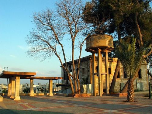
- The house stands near the police fort, now used as prison by the public works dept.
Posted by Uri Zackhem - The house stands near the police fort, now used as prison by the public works dept. #2
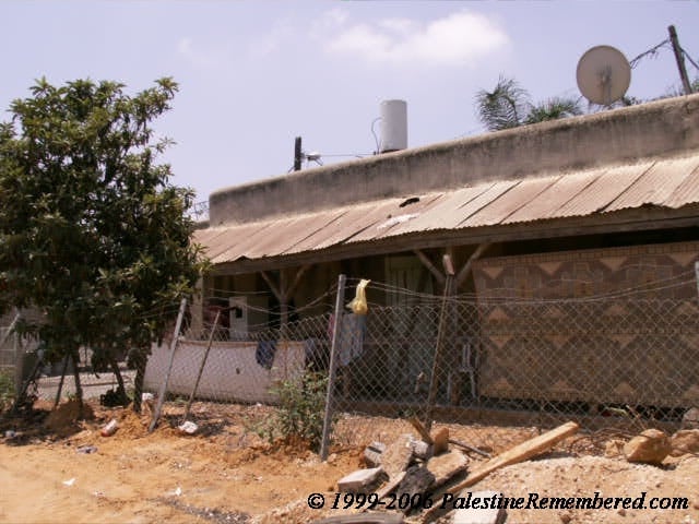
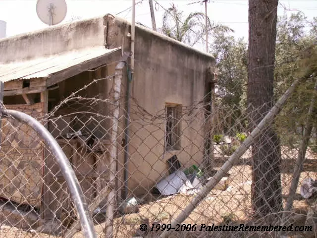
Posted by Uri Zackhem 1 - بيت النابلسي في مستعمرة كفار يونا
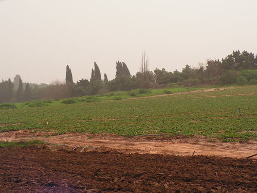
Posted by Wadina - الحقول حول خربة بيت ليد وكفار يونا
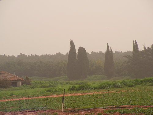
Posted by Wadina - الحقول في الأراضي المحيطة بخربة بيت ليد وكفار يونا
Posted by Wadina - اراضي في منطقة خربة بيت ليد
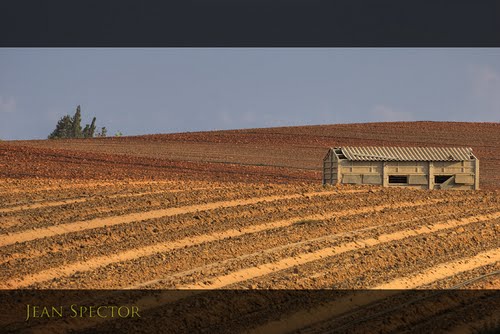
Posted by Wadina - اراضي زراعية - كفار يونا قرب خربة بيت ليد
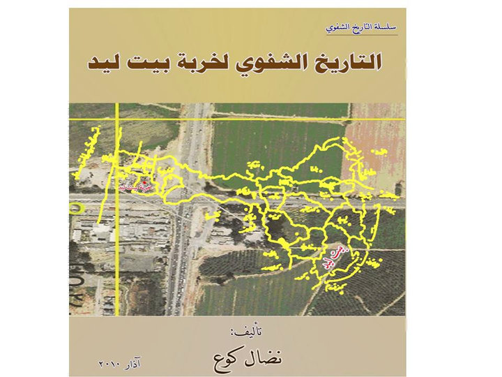
Posted by Wadina - الكتاب هو ثمرة جهود متواصلة من سلسلة التاريخ الشفوي وهو الأول من نوعه عن خربة بيت ليد المهجرة، منذ نكبة فلسطين منذ عام 1948م
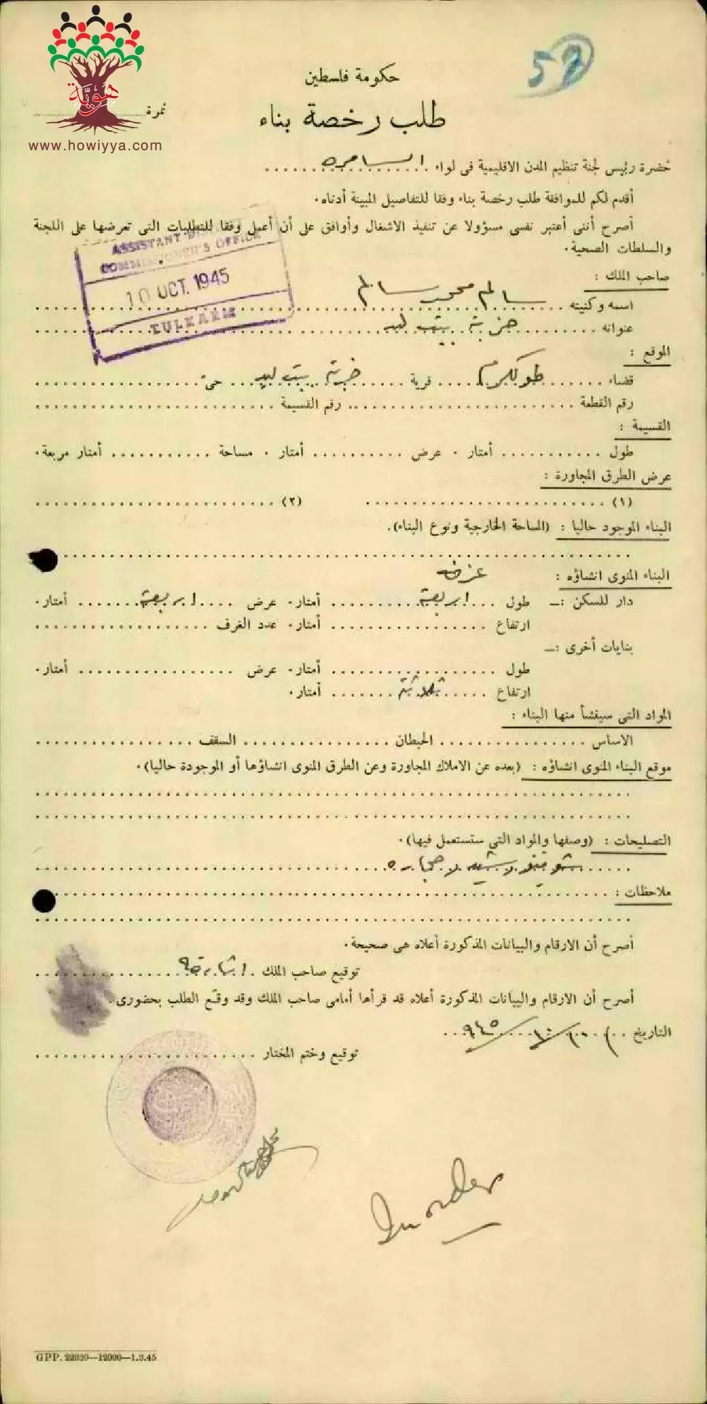
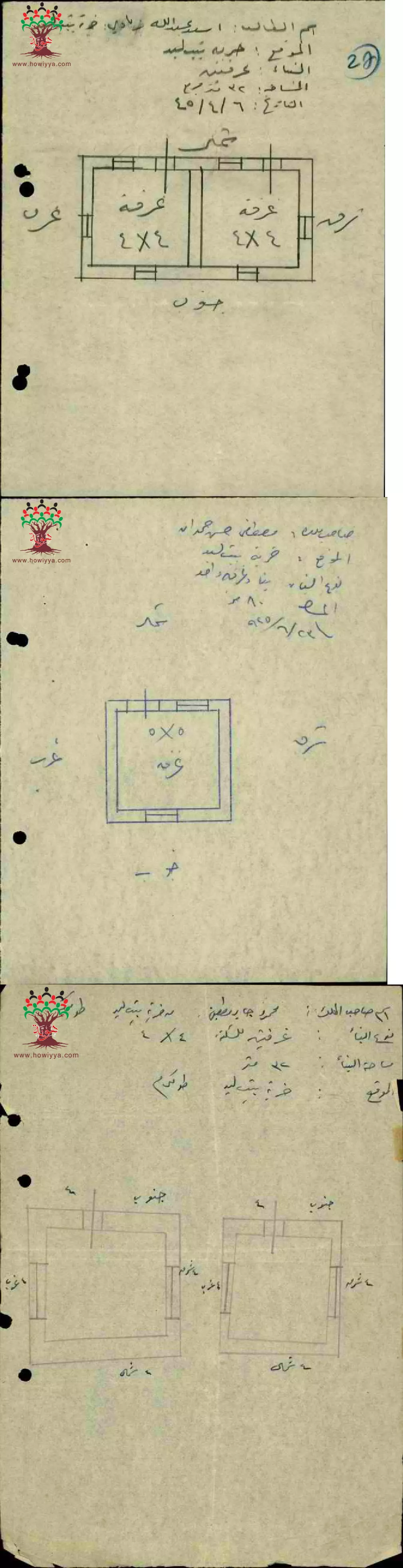
2 - طلب رخصة بناء للمواطن سالم محمد سالم-خربة بيت ليد
تاريخ الوثيقة: 09/10/1945
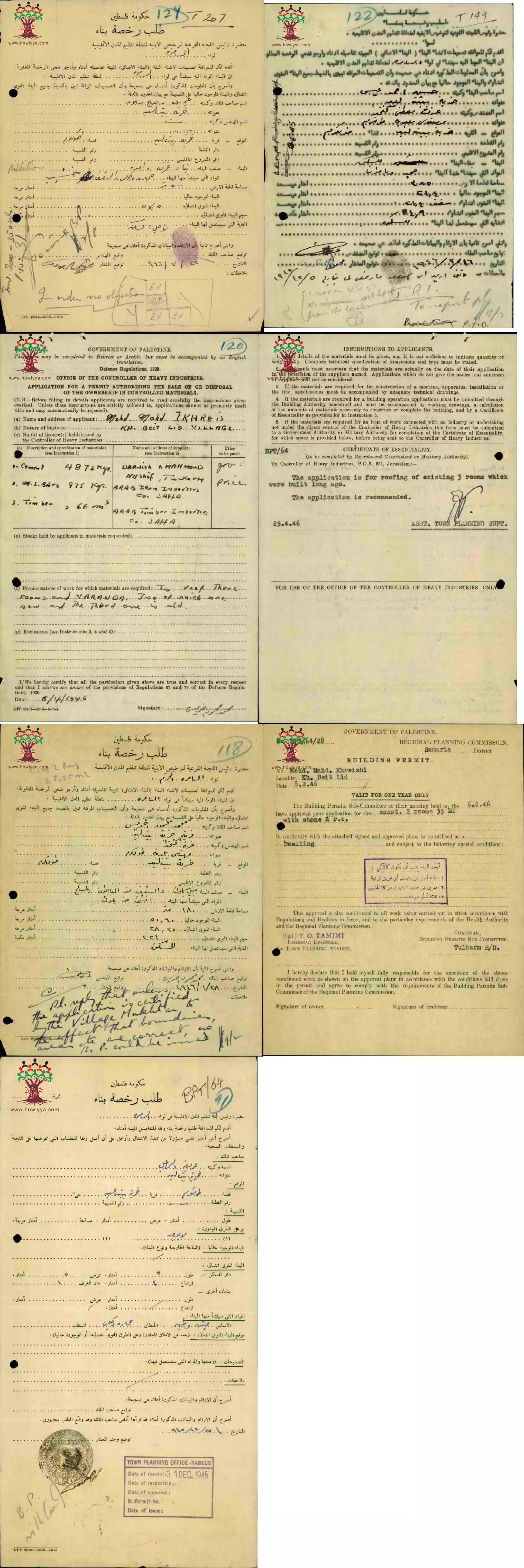
- طلب رخصة بناء للمواطن محمد خريشي-خربة بيت ليد-تاريخ --لوثيقة: 06/02/1946

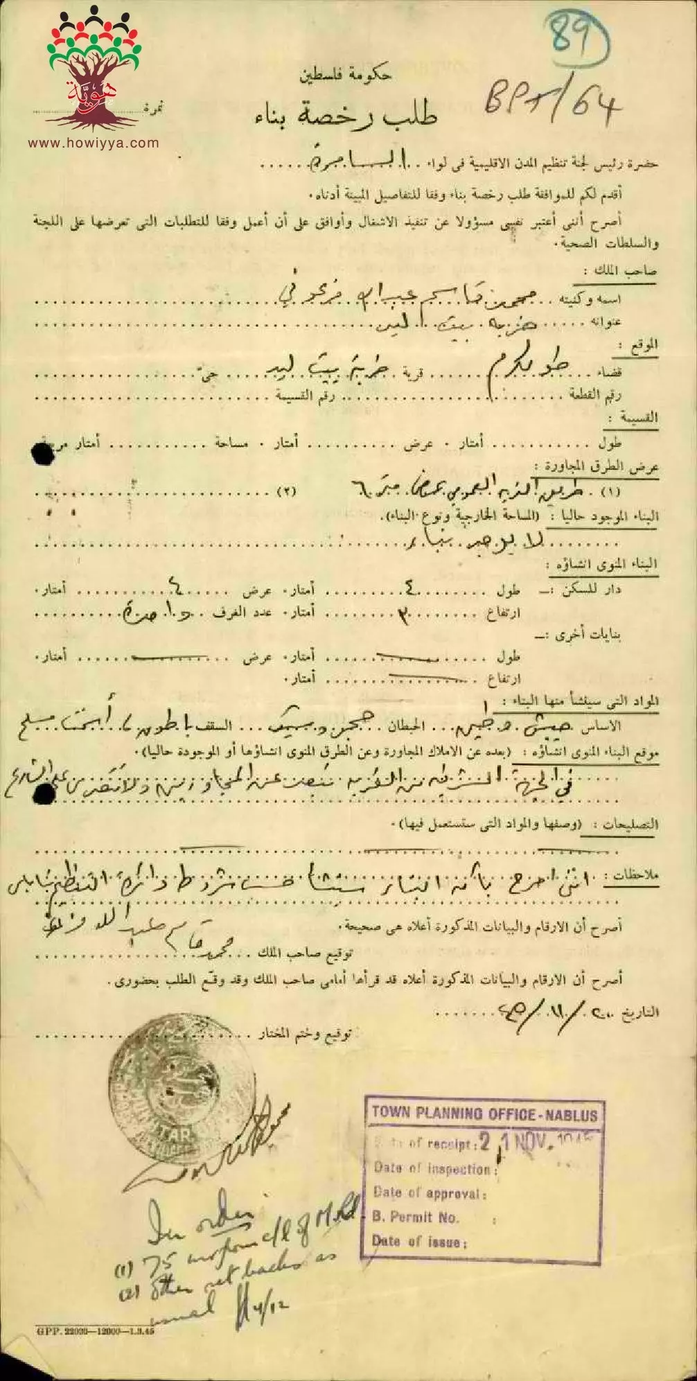
- طلب رخصة بناء للمواطن محمد قاسم عبد الله فرعوني-خربة بيت ليد-تاريخ الوثيقة: 19/11/1945
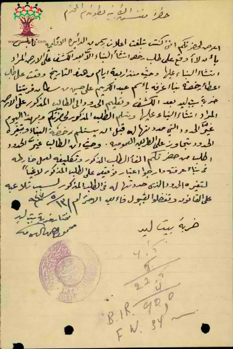
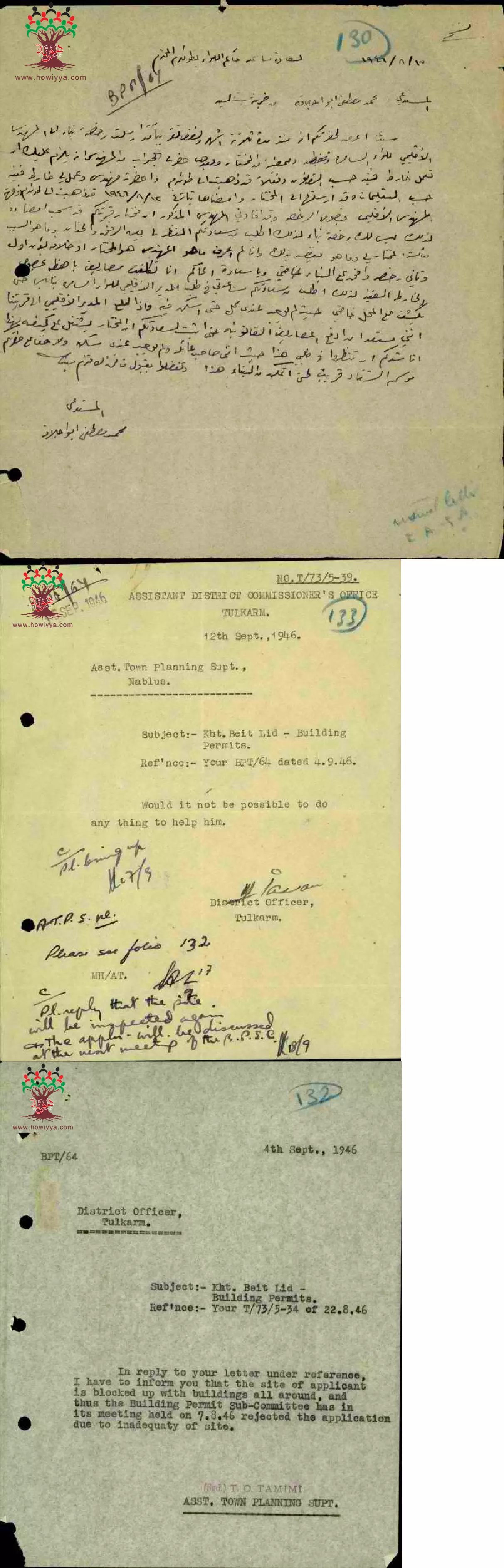
- رسالة من مختار قرية خربة بيت ليد الى مفتش الأبنية بطولكرم بخصوص تغيير عبد الكريم علي حسن لخرائط البناء --13-05-1947
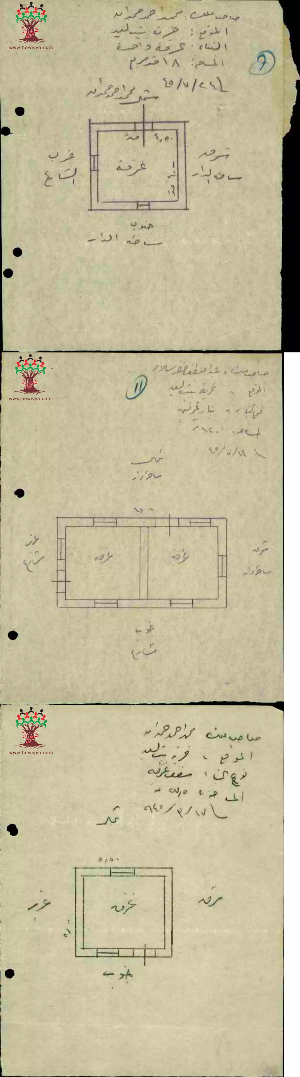
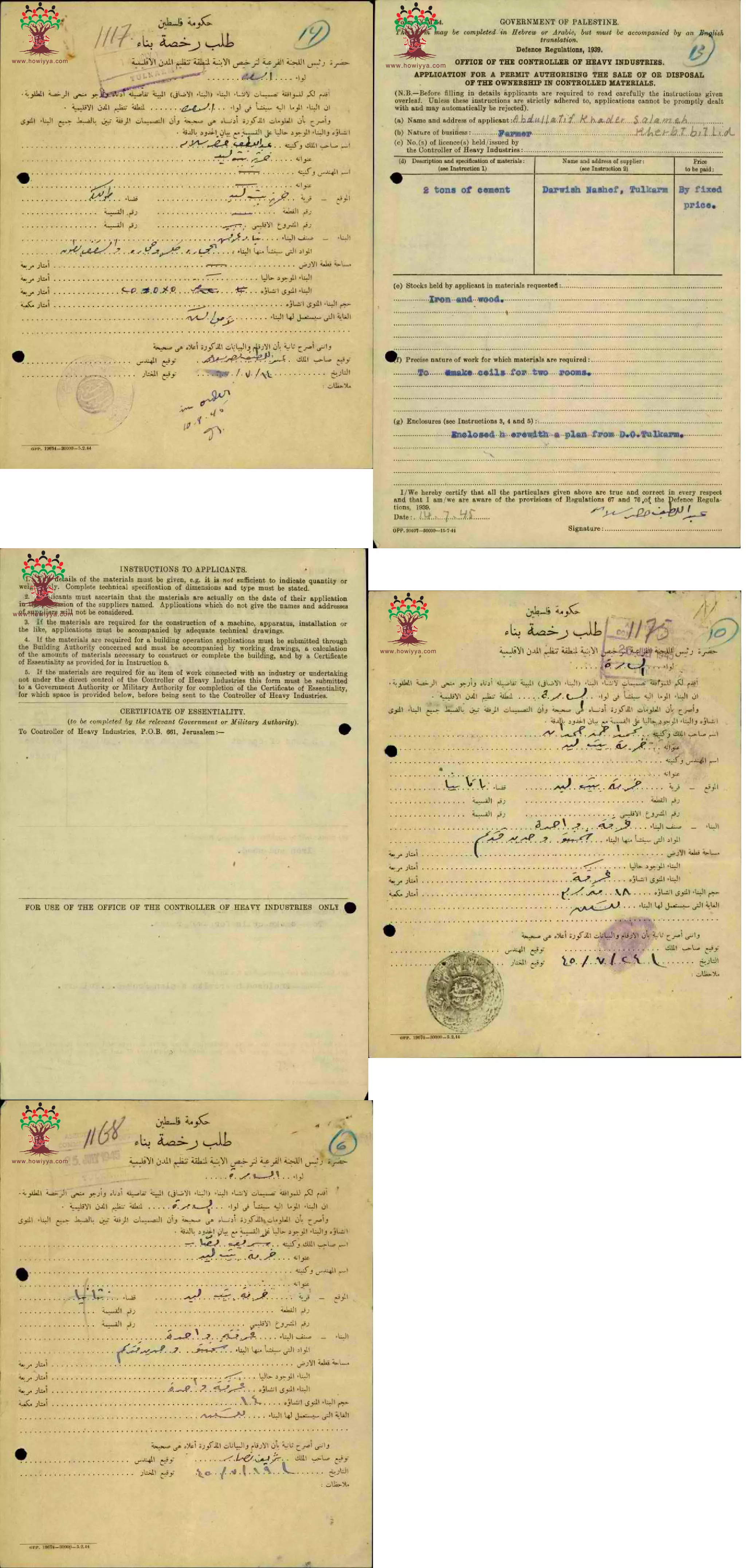
- خرائط بناء ل محمد أحمد حمدان و ل عبد اللطيف خضر سلامة في خربة بيت ليد -- 1945 --أنقر الصورة لتكبيرها
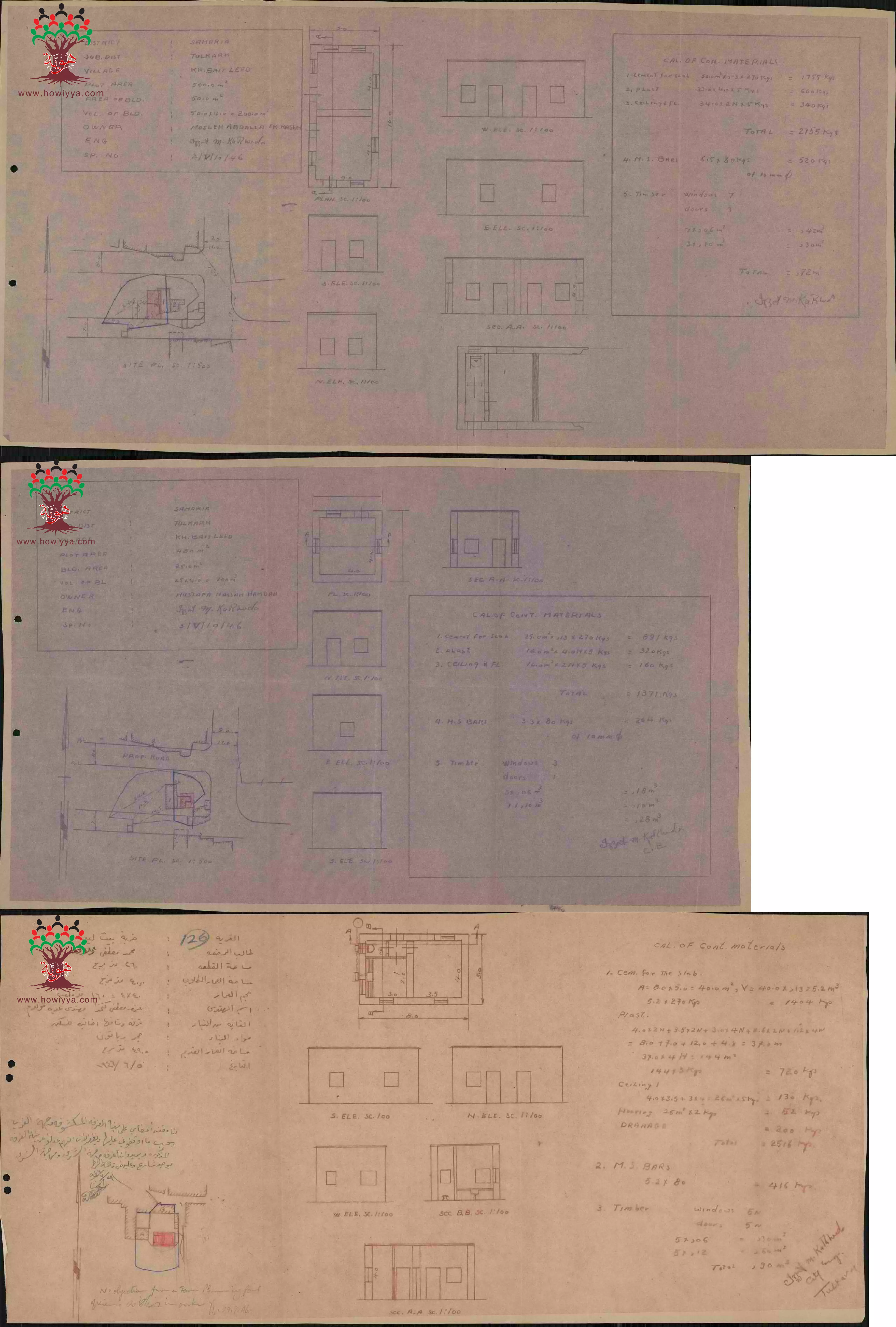
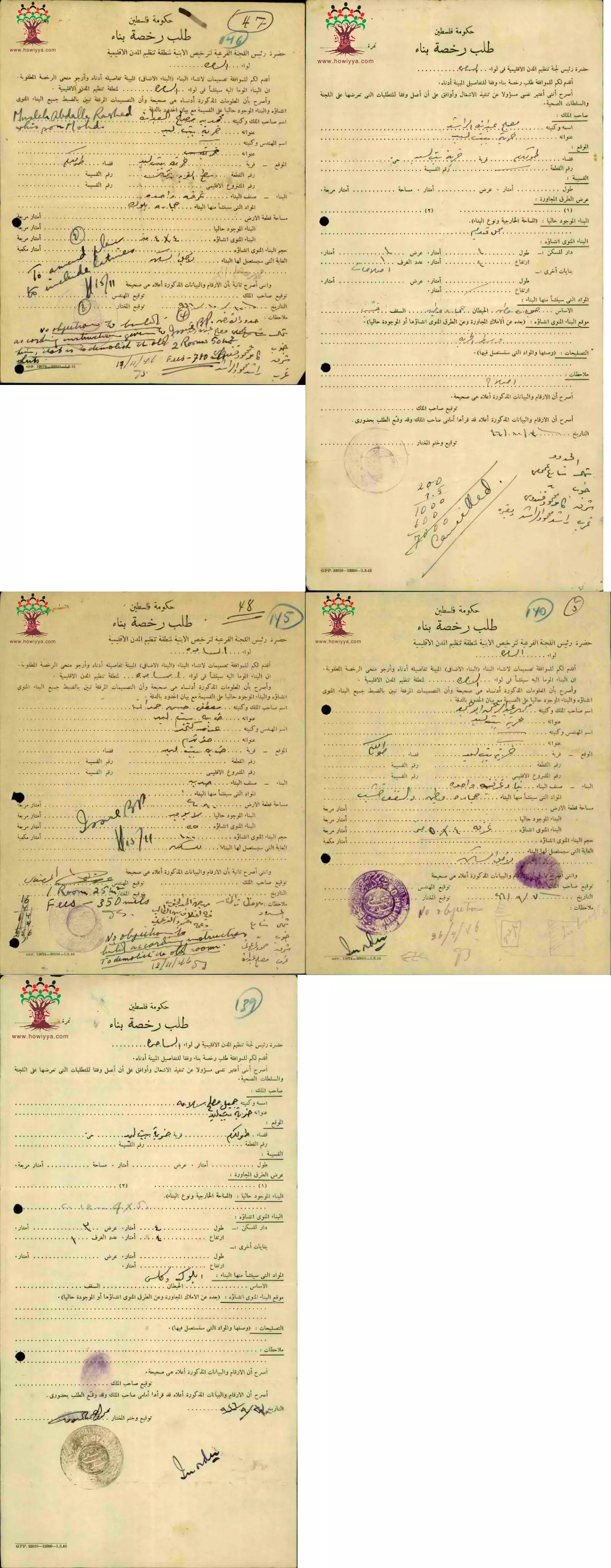
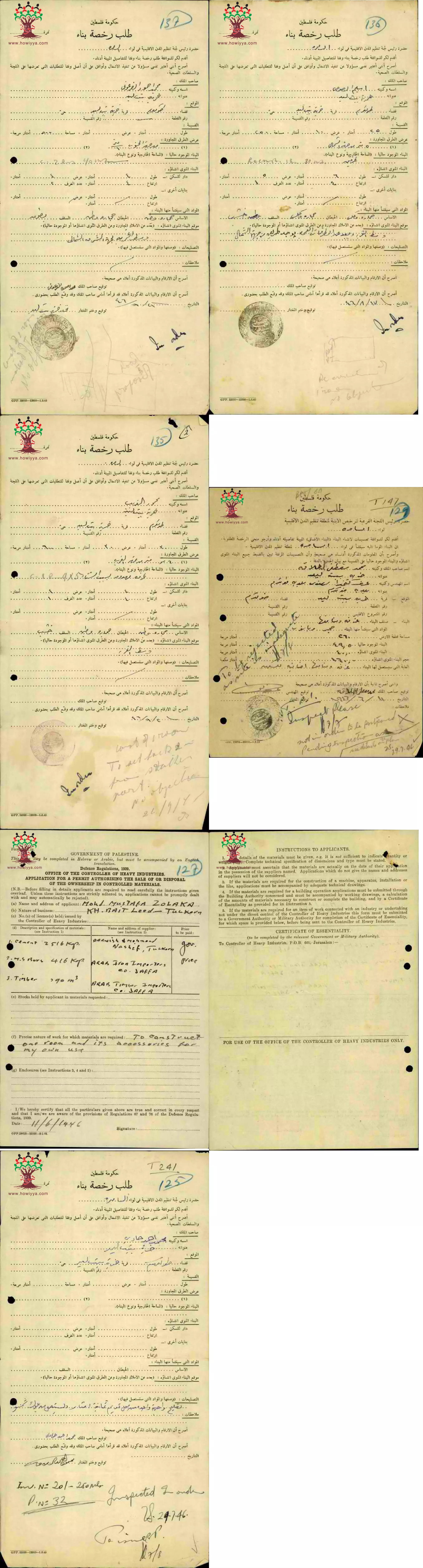
- خرائط بناء ل مصلح عبد الله الراشد و ل مصطفى حسن حمدان و ل محمد مصطفى زحلاقة في خربة بيت ليد -- 1946 -- أنقر الصورة لتكبيرها
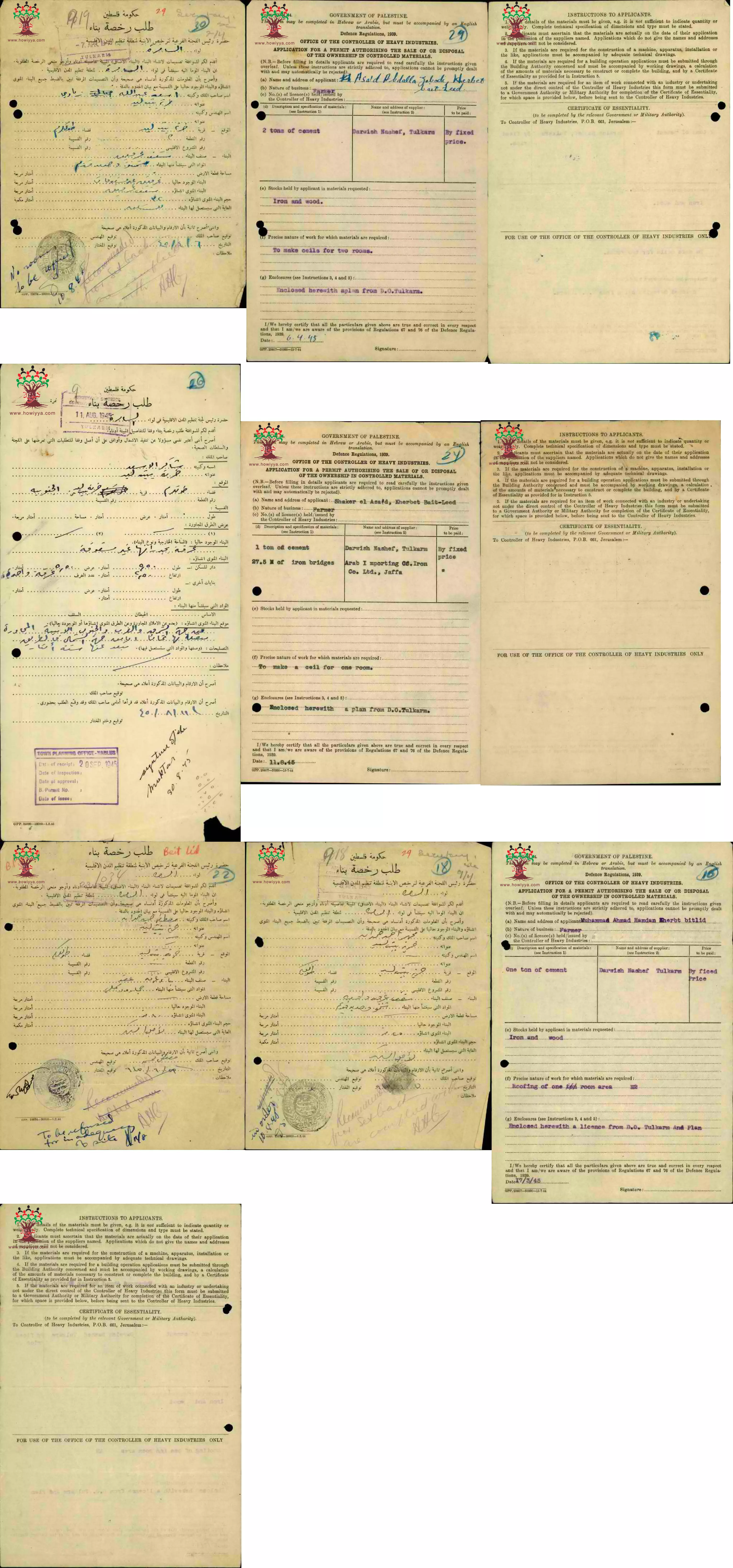
- خرائط بناء ل أسعد عبد الله زبادي و ل صطفى حسن حمدان و ل محمود جابر مصطفى في خربة بيت ليد -- 1945 -- أنقر الصورة لتكبيرها
- مجموعة رسائل بخصوص سحب مختار خربة بيت ليد امضائه عن خريطة بناء محمد مصطفى زحلاقة -- 1946 -- أنقر الصورة لتكبيرها
-
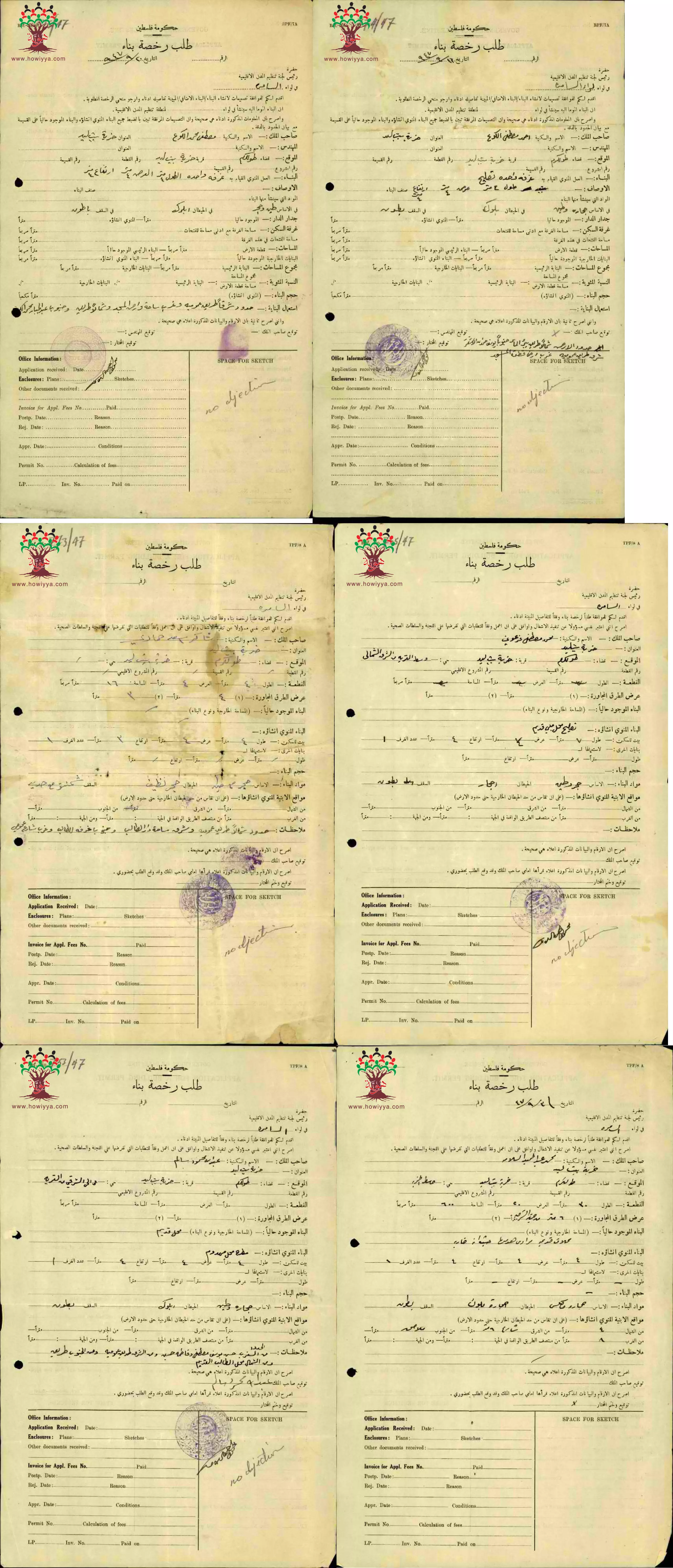
مجموعة طلبات لرخص بناء ل محمد مصطفى الكوع و ل أحمد مصطفى الكوع و ل محمد مصطفى الفرعوني و ل عبد الله محمود سالم و ل محمد عبد الحميد سلامة -- 1947 -- أنقر الصورة لتكبيرها
- مجموعة طلبات لرخص بناء ل عارف عبد الحميد سلامة و ل عيد علي حسين -- 1947 -- أنقر الصورة لتكبيرها
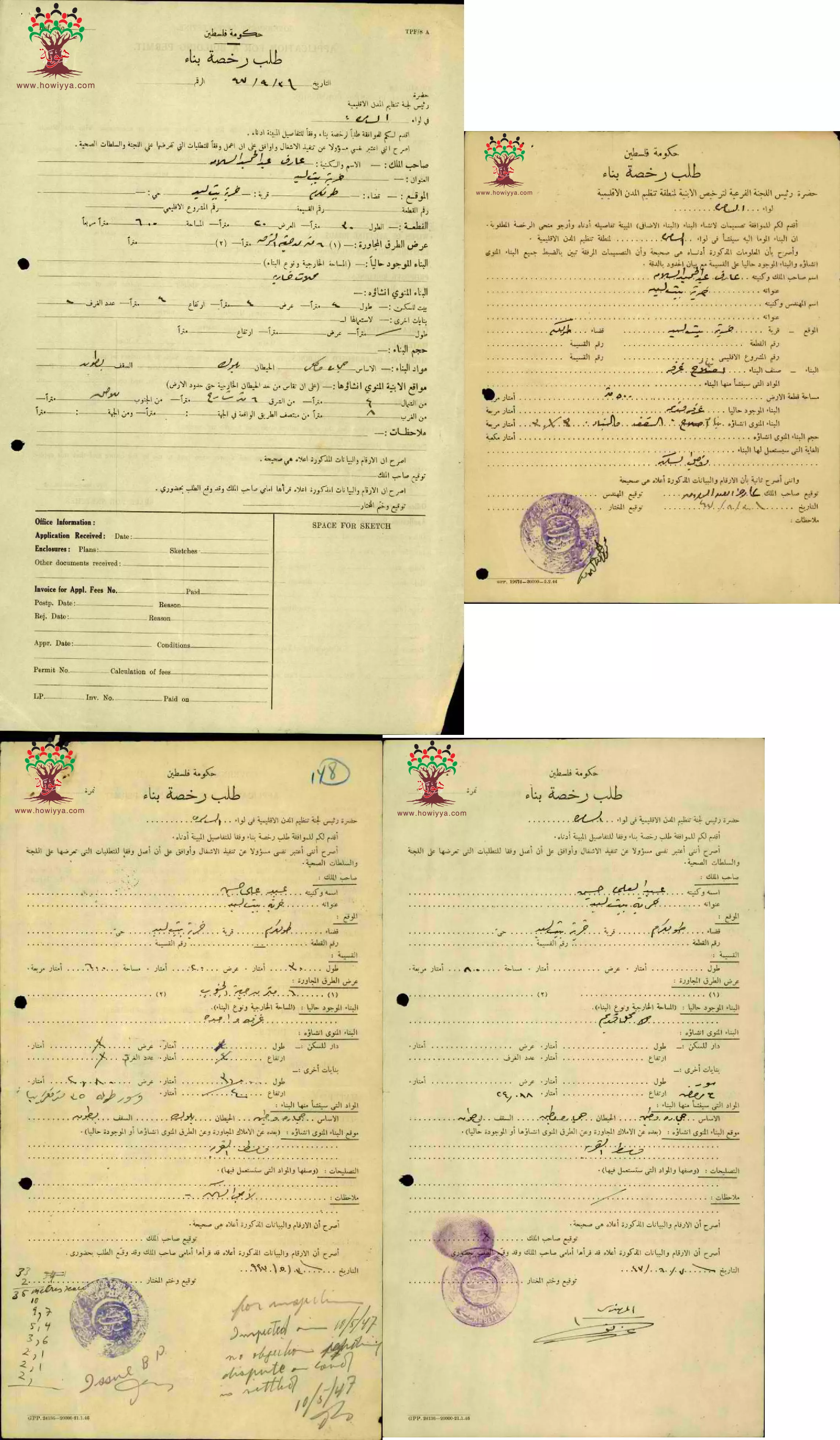
- مجموعة طلبات لرخص بناء ل مصلح عبد الله الراشد و ل مصطفى حسن حمدان و ل محمد عبد الرحمن ابو حميد و ل جميل مصلح سلامة في خربة بيت ليد-- 1946 -- أنقر الصورة لتكبيرها
- مجموعة طلبات لرخص بناء ل حمد الفرعوني و ل سليم الصوص و ل محمود الغريب و ل محمد مصطفى زحلاقة ول محمد أحمد حمادي في خربة بيت ليد-- 1946 -- أنقر الصورة لتكبيرها
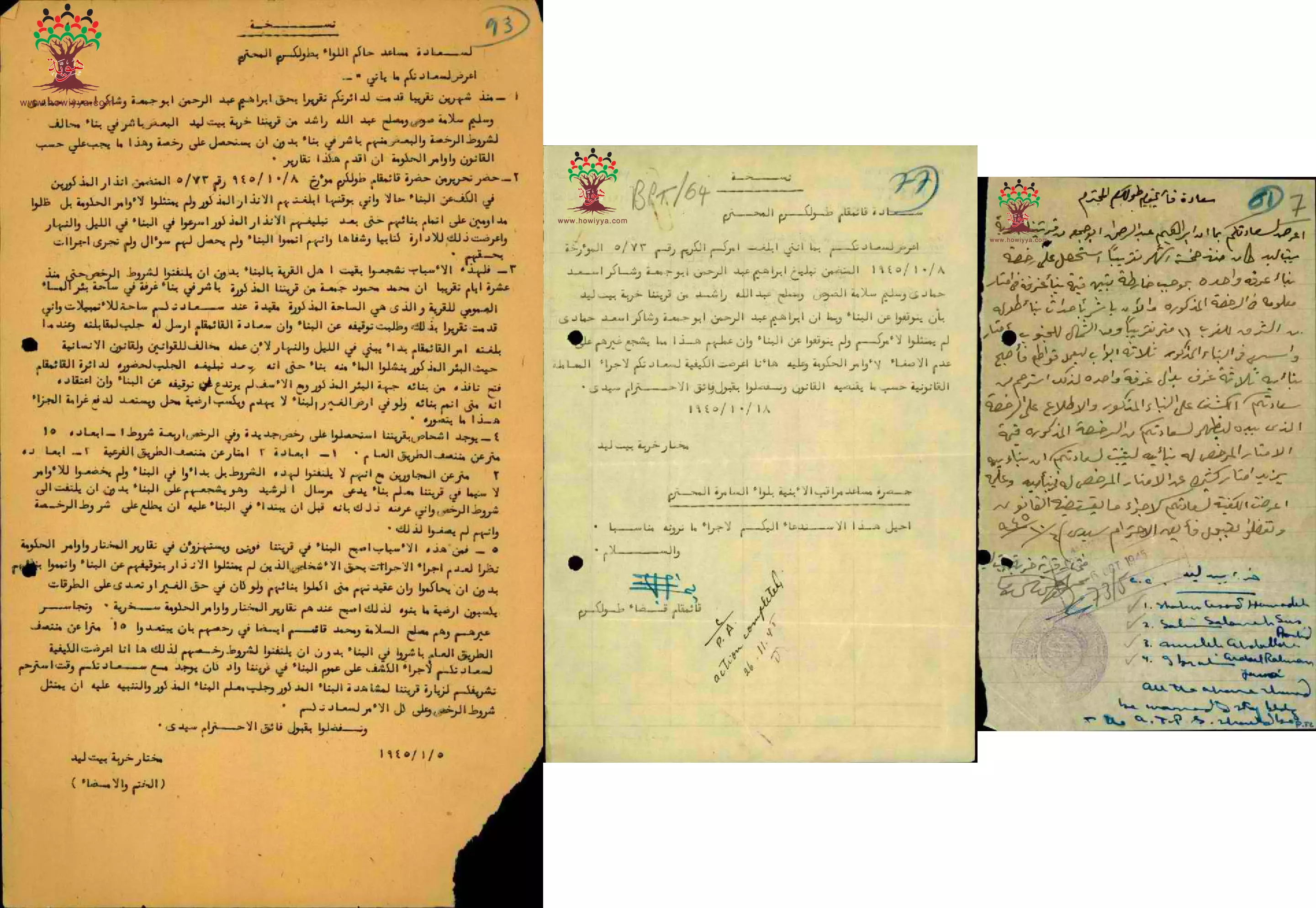
- رسائل من مختار خربة بيت ليد الى حاكم اللواء ب طولكرم بخصوص مخالفات بعض الأشخاص لشروط رخصة البناء -- 1945 -- أنقر الصورة لتكبيرها
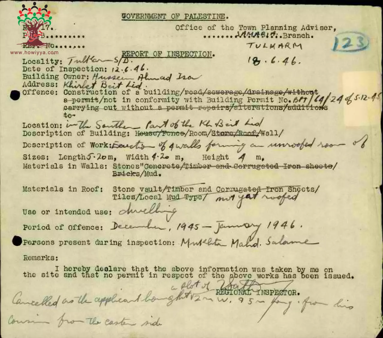
- تقرير الكشف على بناء حسين أحمد عيسى -- 1946
- مجموعة طلبات لرخص بناء ل جميل مصلح سلامة و ل حسين أحمد عيسى و ل حمد محمود خريس و ل عريفة اسماعيل في خربة بيت ليد-- 1946 -- أنقر الصورة لتكبيرها
- مجموعة طلبات لرخص بناء ل عبد الرحمن جابر الكوع و ل محمد قاسم عبد الله فرعوني و ل عبد الرحمن ابراهيم أبو جمعة و ل حمود عبد الرحمن زبادي في خربة بيت ليد-- 1946 -- أنقر الصورة لتكبيرها
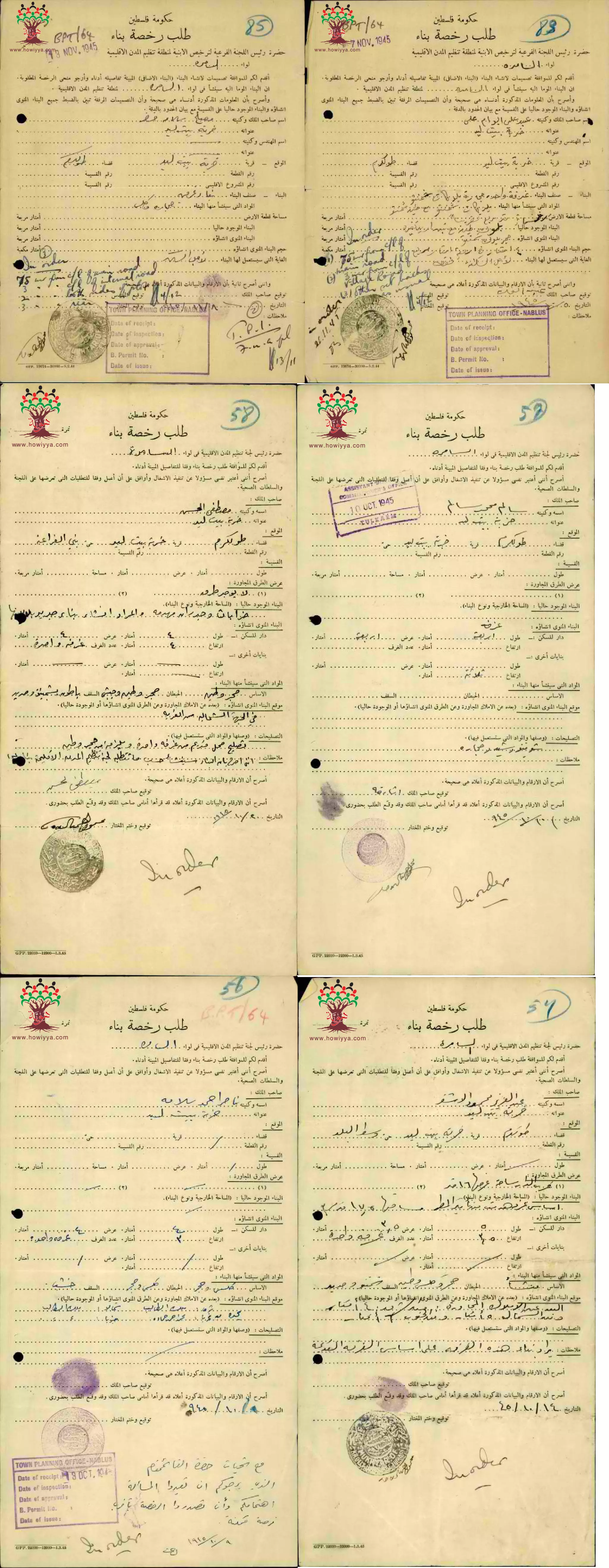
- مجموعة طلبات لرخص بناء ل مصلح سلامة خضر و ل عبد علي علي و ل صطفى الحسن و ل سالم محمد سالم و ل ناصر أحمد سلامة و ل عبد العزيز محمود الأشقر- في خربة بيت ليد-- 1946 -- أنقر الصورة لتكبيرها
- مجموعة طلبات لرخص بناء ل أحمد محمود الحمدان و ل أحمد محمد همشري و ل شريف نصار و ل يسى مسعود أبو زهرة و ل عبد الرحيم جابر الكوع و ل عبد الله أحمد جمعة في خربة بيت ليد-- 1946 -- أنقر الصورة لتكبيرها
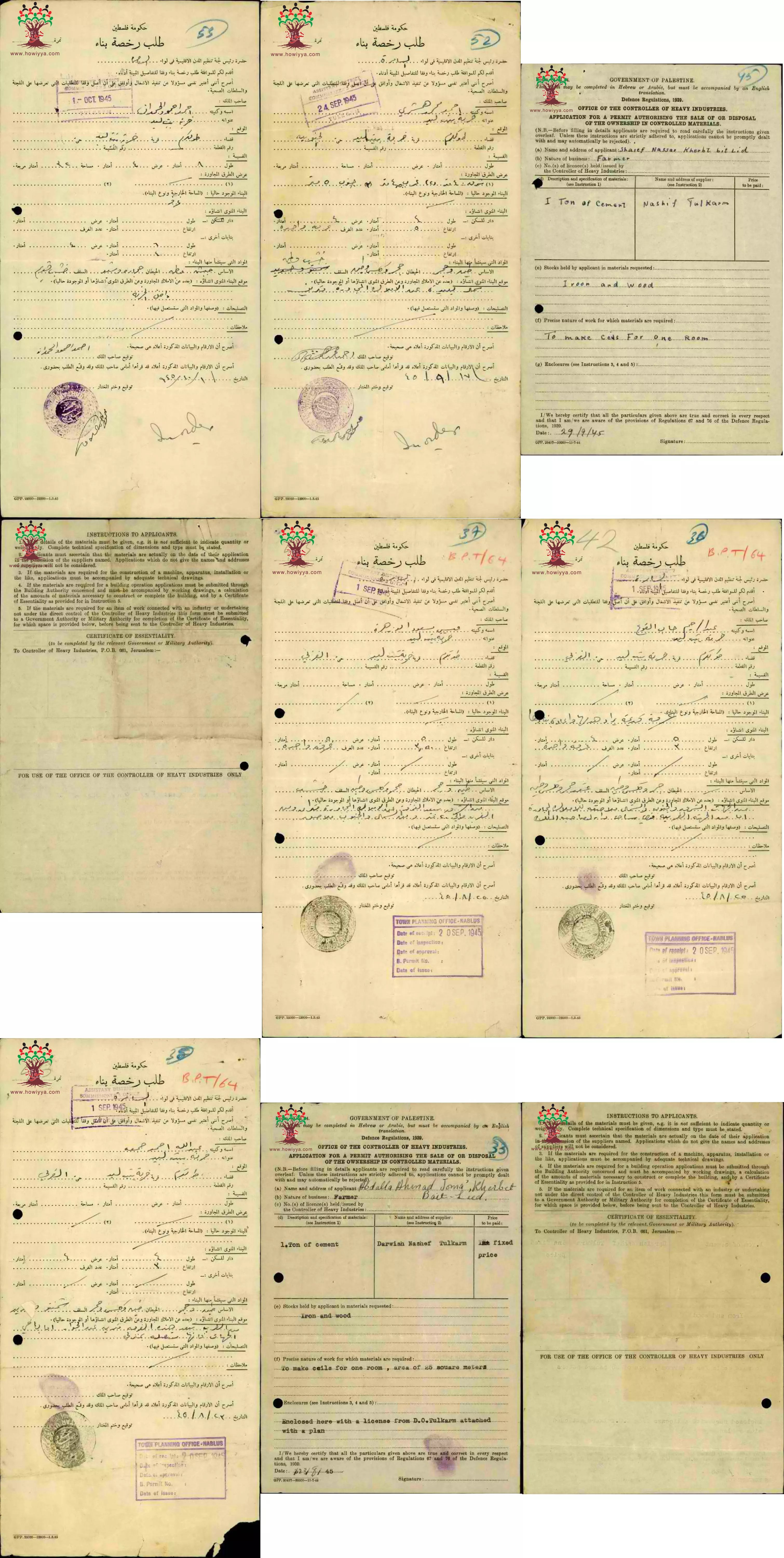
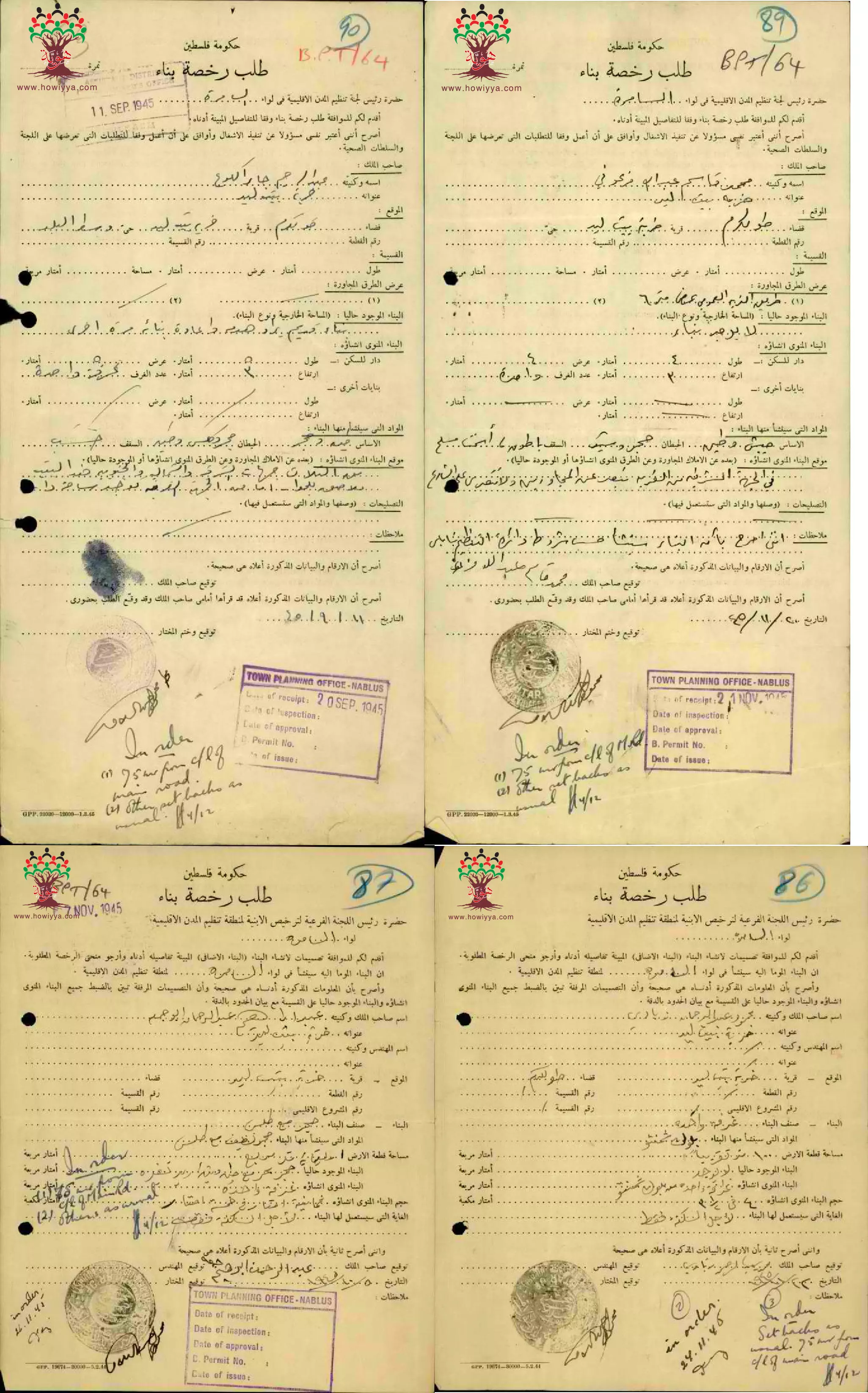
- مجموعة طلبات لرخص بناء ل أسعد عبد الله زبادي و ل شاكر الأسعد و ل شاكر الأسعد و ل مصطفى حسن حمدان ول محمد أحمد حمدان في خربة بيت ليد-- 1945 -- أنقر الصورة لتكبيرها
- مجموعة طلبات لرخص بناء ل عبد اللطيف خضر سلامة و ل محمد أحمد حمدان و ل شريف نصار في خربة بيت ليد-- 1945 -- أنقر الصورة لتكبيرها
Want to browse more? 80,000 pictures were grouped in these gallaries:
- طلب رخصة بناء للمواطن سالم محمد سالم-خربة بيت ليد
تاريخ الوثيقة: 09/10/1945
- طلب رخصة بناء للمواطن محمد خريشي-خربة بيت ليد-تاريخ --لوثيقة: 06/02/1946
- طلب رخصة بناء للمواطن محمد قاسم عبد الله فرعوني-خربة بيت ليد-تاريخ الوثيقة: 19/11/1945
- خرائط بناء ل محمد أحمد حمدان و ل عبد اللطيف خضر سلامة في خربة بيت ليد -- 1945 --أنقر الصورة لتكبيرها
- خرائط بناء ل مصلح عبد الله الراشد و ل مصطفى حسن حمدان و ل محمد مصطفى زحلاقة في خربة بيت ليد -- 1946 -- أنقر الصورة لتكبيرها
- مجموعة رسائل بخصوص سحب مختار خربة بيت ليد امضائه عن خريطة بناء محمد مصطفى زحلاقة -- 1946 -- أنقر الصورة لتكبيرها
-
مجموعة طلبات لرخص بناء ل محمد مصطفى الكوع و ل أحمد مصطفى الكوع و ل محمد مصطفى الفرعوني و ل عبد الله محمود سالم و ل محمد عبد الحميد سلامة -- 1947 -- أنقر الصورة لتكبيرها
- مجموعة طلبات لرخص بناء ل عارف عبد الحميد سلامة و ل عيد علي حسين -- 1947 -- أنقر الصورة لتكبيرها
- مجموعة طلبات لرخص بناء ل مصلح عبد الله الراشد و ل مصطفى حسن حمدان و ل محمد عبد الرحمن ابو حميد و ل جميل مصلح سلامة في خربة بيت ليد-- 1946 -- أنقر الصورة لتكبيرها
- مجموعة طلبات لرخص بناء ل حمد الفرعوني و ل سليم الصوص و ل محمود الغريب و ل محمد مصطفى زحلاقة ول محمد أحمد حمادي في خربة بيت ليد-- 1946 -- أنقر الصورة لتكبيرها
- مجموعة طلبات لرخص بناء ل جميل مصلح سلامة و ل حسين أحمد عيسى و ل حمد محمود خريس و ل عريفة اسماعيل في خربة بيت ليد-- 1946 -- أنقر الصورة لتكبيرها
- مجموعة طلبات لرخص بناء ل عبد الرحمن جابر الكوع و ل محمد قاسم عبد الله فرعوني و ل عبد الرحمن ابراهيم أبو جمعة و ل حمود عبد الرحمن زبادي في خربة بيت ليد-- 1946 -- أنقر الصورة لتكبيرها
- مجموعة طلبات لرخص بناء ل مصلح سلامة خضر و ل عبد علي علي و ل صطفى الحسن و ل سالم محمد سالم و ل ناصر أحمد سلامة و ل عبد العزيز محمود الأشقر- في خربة بيت ليد-- 1946 -- أنقر الصورة لتكبيرها
- مجموعة طلبات لرخص بناء ل أحمد محمود الحمدان و ل أحمد محمد همشري و ل شريف نصار و ل يسى مسعود أبو زهرة و ل عبد الرحيم جابر الكوع و ل عبد الله أحمد جمعة في خربة بيت ليد-- 1946 -- أنقر الصورة لتكبيرها
- مجموعة طلبات لرخص بناء ل أسعد عبد الله زبادي و ل شاكر الأسعد و ل شاكر الأسعد و ل مصطفى حسن حمدان ول محمد أحمد حمدان في خربة بيت ليد-- 1945 -- أنقر الصورة لتكبيرها
- مجموعة طلبات لرخص بناء ل عبد اللطيف خضر سلامة و ل محمد أحمد حمدان و ل شريف نصار في خربة بيت ليد-- 1945 -- أنقر الصورة لتكبيرها
| Display Name | Clan/Hamolah | Country of Residence |
| العنقاء | سلامة | - |
| احمد | السلامه | اربد, الاردن |
| علم | ال عامر | طولكرم, بيت ليد |
| طارق جابر | جابر | Zarqa |
| monther abu shayeb | - | ABU DHAB |
| abu almajd | Al-Shareef | - |
No links have been shared yet, be free to the first to share the first link.
 Fake Valor: Why Did Zionist Jews Hoist Nazis Flag on Their Ships in the 1930s?
What is new?
-
Facts About Oct. 7th Gaza Raid
-
Remined Us Please: Who Did Rape Whom? Was it Palestinians who raped Israelis? Or, was the other way around? You'll be the judge
-
When Prof. Edward Said was invited to debate Bibi Netanyahu in the 1980s, watch what happened!
-
Ezra Klein of the NY Times on the "Jewish Race".
-
Abusing Blood Libel!
-
How and why Israeli Jewry has become the most hated cult?
-
Did Israeli Soldiers Activate The Hannibal Direective On Oct. 7th? You Be The Judge
-
Zionist FAQ: Isn't it true that Palestinians don't want peace? Palestinians never accepted the two-state solution
- Facts about Haavara (Transfer) Agreement between Ben-Gurion & Hitler
-
Haavara FAQs: Why Did Zionist Jews Hoist Nazis' Flags on Their Ships in the 1930s?
- Haavara FAQs: When Chaim Weizmann met FDR in mid-1943, why was he silent about rescuing European Jewry?
-
Dear ChatGPT: How did Palestinians resist Napoleon's invasion of their country in 1799?
-
Dear ChatGPT: Gaza had a vibrant Jewish community in the mid-17th century. What happened to them?
-
Dear ChatGPT: Why did the Jewish Agency suppress news of the Holocaust during WWII?
-
Video Playlist: Jews share their DNA tests to end the conflict for good.
-
A Tale of Two Conflicts: Examining the Definition of Genocide
-
Prof. Abraham Polak And The Suppressed History of the Khazars and European Jewry
-
How Ronald Reagan would have framed the genocide in Gaza if he were still alive?
-
Haavara FAQs: Let us do the math: how many German Jews did The Haavara Agreement save?
-
Zionist FAQs: The Hebron Massacre of 1929, "clearly proves" that Palestinians are antisemitic, how could you deny it?
-
Zionist FAQs: Why Anti-Zionist Is Not Antisemitism?
-
Zionist FAQs: Isn't it true that the KGB created Palestinian Nationalism in the early 1960s?
- Zionist FAQs: Muslims are killing Muslims all the time; why are Israeli Jews being singled out in the media?
- Zionist FAQs: How is Israel an apartheid state when 20% of its citizens are Arabs who enjoy full rights?
-
Haavara FAQs: Why Did Dorothy Thompson Flip From A Zionist Advocate to A Silenced Dissenter?
-
Haavara FAQs: Analysis of Herzl's Uganda Scheme and how it could have saved millions of Jews.
-
Haavara FAQs: Why did Hayim Greenberg describe American Jewry as "morally bankrupt" in early 1943?
-
Haavara FAQs: What if the Evian Conference was a resounding success? What would have been the impact of saving European Jewry on Zionism?
- Haavara FAQs: What if the six million were saved, how that would have impacted the Zionist project?
-
Haavara FAQs: How did Zionist leaders react when Europe's Jews lingered in the DP camps after WWII ended?
-
Why does the American Jewish community repeat lies that David Ben-Gurion had debunked before he died?
-
Who has the power to rename the Tatar/Khazar Gene Marker to Jewish IV?
-
Zionist FAQs: Why won't Egypt, Syria, and Jordan take their people back? Jews are indigenous to Palestine, and Arabs immigrated after Jews developed the country. Arabs should leave.
-
Haavara FAQs: Did Hitler and the Nazis conflate between Judaism and Zionist? If that wasn't case, then why?
-
Haavara FAQs: Winston Churchill and antisemitism, a collection of articles written Churchill.
-
Haavara FAQs: Broken by country, how many Jews survived vs. killed during the Holocaust?
-
Haavara FAQs: Why did European Jews vote with their feet and to immigrated to the Americas, not Palestine, after WWII?
-
Watch this American Jewish Girl describing Israeli Jews' cognitive dissonance like no other in under two minutes
-
Haavara FAQs: When the Nazis went out of their way to hide the Holocaust, Israeli Jews did the exact opposite by broadcasting their genocide of Gazans. But why?
-
Haavara FAQs: How Zionist Jews went out of their to show their appreciation to Nazism and Fascism?
- Haavara FAQs: Why Zionist leaders were against bombing the death camps & the Railroads leading to them?
-
Haavara FAQs: Hitler's message to the British and American people: If Jews are such noble citizens and you care about them, how come you're not letting them in? I will gladly ship them to you at my expense, even on luxury liners!
-
A shortlist of Zionist and Israeli false flag operations in the name Jews.
-
The Most Moral Army
- The Land of Kapos (Israel): Where the brave are boycotted and Kapos walk free.
- Why did early Zionists often named their communal enterprises "colonial"?
- Zionist Relations with Nazi Germany by Faris Glubb
-
Two NY Times advertisements by Zionists in the early 1943 that exposes Zionists' treason at the height of the calamity
- Facts Not Lies about the Palestinian-Israeli Conflict.
- Site's pictures have been categorized
- Campgain Against Lice
- A Survey of Palestine, the official source about Palestine before Nakba produced by the British Mandate; over 1200 pages.
- Satellite View & Google Earth: Over 6,000 placemarks identifying all destroyed towns, W. Bank & Gaza Strip Towns, & refugee camps.
- PalestineRemembered.com and its Nakba Oral History Project were featured on al-Jazeera Satellite TV.
- Nakba Oral History Video Podcast:
 Over 700 Oral History interviews (including 3,500+ hours of recording) can be viewed online.
 - Palestine Village Statistics Project
- Gaza Jail Break
- النسخة العربية للموقع الان متوفرة
- Videos: Documenting the destroyed villages in video: Tracing all that remains since Nakba.
- Videos: Responding to Zionist Propaganda
- Interview: The ethnic cleansing of Palestine: George Galloway interviews Israeli Historian Ilan Pappe.
- For Palestinians, memory matters. It provides a blueprint for their future By George Bisharat.
- Zionist FAQ now available in Hebrew שאלות שציונים שואלים, עכשיו בעברית
- Video: The Stephen Walt and John Mearsheimer report on the influence of the Israel Lobby on U.S. Foreign Policy
- The Palestinian-Israeli conflict for beginners
