| PalestineRemembered | About Us | Oral History | العربية | |
| Pictures | Zionist FAQs | Haavara | Maps | |
| Search |
| Camps |
| Districts |
| Acre |
| Baysan |
| Beersheba |
| Bethlehem |
| Gaza |
| Haifa |
| Hebron |
| Jaffa |
| Jericho |
| Jerusalem |
| Jinin |
| Nablus |
| Nazareth |
| Ramallah |
| al-Ramla |
| Safad |
| Tiberias |
| Tulkarm |
| Donate |
| Contact |
| Profile |
| Videos |
Welcome To al-Manshiyya - المنشية (ח'ירבת מנשיה)
|
District of Tulkarm
Ethnically cleansed days ago |
العربية Google Earth |
 |
Gallery (3) |
- Statistics & Facts
-
Before & After

- Satellite View
- Articles 2
- Pictures 3
- Aerial Views 1
- Members 1
- All That Remains
- Wikipedia
- Videos
- Guest Book 2
- Links
| Statistic & Fact | Value | ||||||||||||||||||
| Occupation Date | April 15, 1948 | ||||||||||||||||||
| Distance From District | 12.5 (km) Northwest of Tulkarm | ||||||||||||||||||
| Elevation | 25 (meters) | ||||||||||||||||||
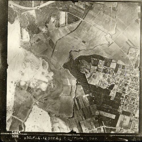
| Before & After Nakba, Click Map For Details |
|||||||||||||||||||
|
|||||||||||||||||||
| Map Location | See location #5 on the map View from satellite |
||||||||||||||||||
| Military Operation | Coastal Clearing | ||||||||||||||||||
| Exodus Cause | Fear of Jewish attack, or of being caught in the fighting | ||||||||||||||||||
| Village Temains | Soon after occupation, al-Manshiyya was completely obliterated, and only house rubble left behind. | ||||||||||||||||||
| Ethnically Cleansing | Based on alleged security concerns, the Jewish National Fund encouraged the Hanaganh to ethnically cleanse the area. We hope one day Palestinians will be more organized and start taking the JNF to court in the US and Europe for war crimes against humanity. | ||||||||||||||||||
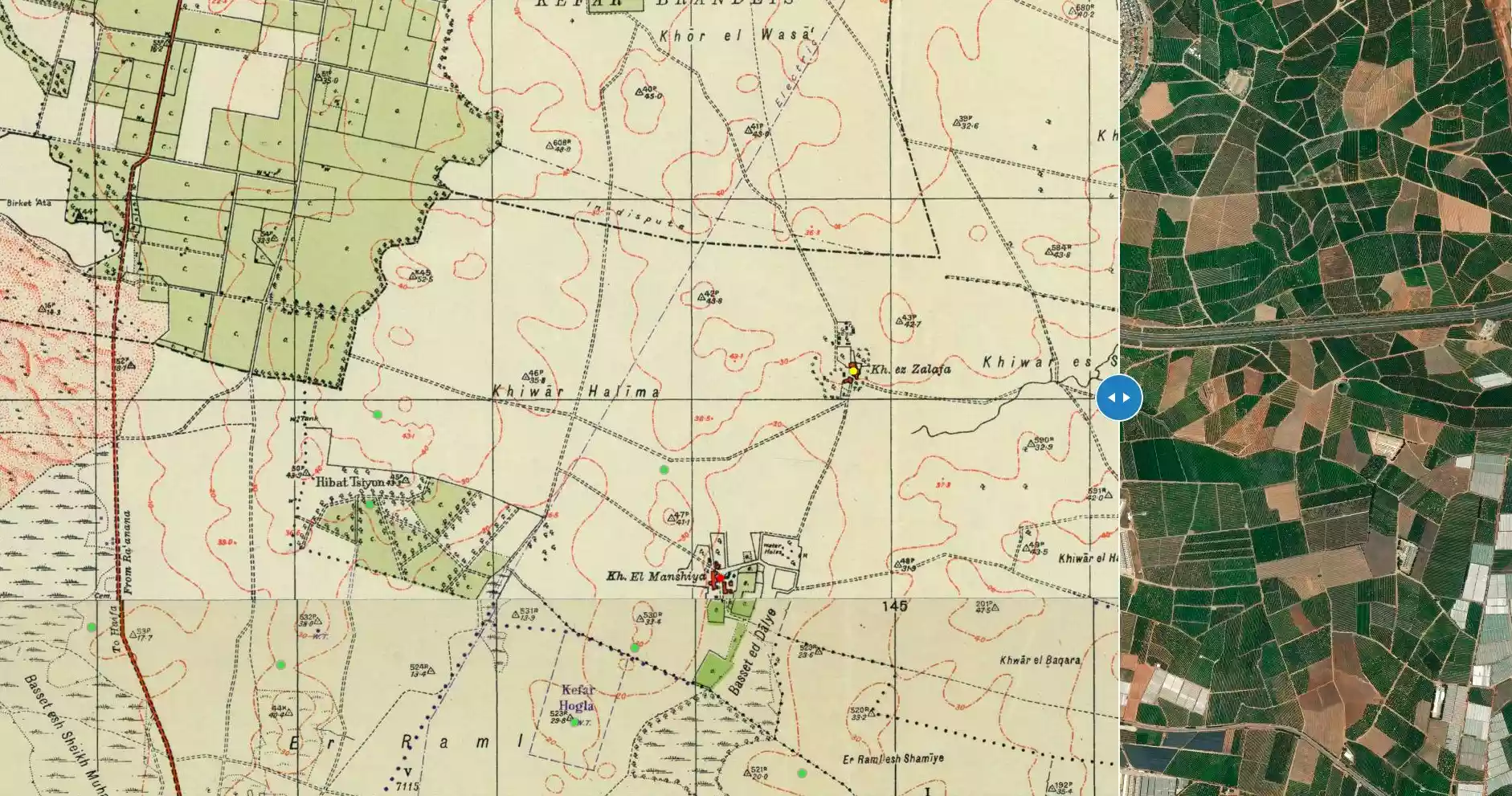
| Pre-Nakba Land Ownership |
**Town Lands' Demarcation Maps |
||||||||||||||||||
| Land Usage As of 1945 |
|
||||||||||||||||||
| Population |
|
||||||||||||||||||
| Near By Towns |
|||||||||||||||||||
|
|||||||||||||||||||
| Inhabitants Place of Origin | al-Manshiyya inhabitants trace their roots to the village of 'Abasan, Gaza. | ||||||||||||||||||
| Exculsive Jewish Colonies Who Usurped Village Lands |
'En ha-Choresh, Giv'at Chayyirn, and Achituv. | ||||||||||||||||||
Village Before NakbaAl-Manshiyya stood on a low, gradually sloping hill in the middle of a wide plain. It was located close to the administrative border between the sub-disctricts of Tulkarm and Haifa. The village lay 3 km east of the coastal highway, to which it was linked by a secondary road. Secondary roads also linked it to other villages. Al-Manshiyya's layout was rectangular. Some houses were built along the road to the village of Qaqun, in the south. The villagers traced their origin to the village of Abasan. Water for drinking and irrigation came from several wells around the site. Agriculture was based primarily on grain, although other fruits, including melons, were planted as well. In 1944/45 only 1 dunum was devoted to citrus and bananas and 12,485 dunums were allocated to cereals; 12 dunums were irrigated or used for orchards. Woodlands spread west and south of the village.Village Occupation and Ethnic CleaningAs early as 13 April, Haganah chief Israel Galili wrote to the Jewish National Fund that it was 'important to security' for settlements to be established at several sites on Haganah-occupied territory, including al-Manshiyya.'On or about' 15 April 1948, the residents of al-Manshiyya evacuated their village and moved eastwards, according to Israeli historian Benny Morris. Morris interviewed the local Haganah intelligence officer in 1985, who claimed that he had pleaded with the villagers to remain and to accept Haganah protection. On their departure, the villagers had reached an agreement with Haganah representatives that local Jewish settlements would safeguard their property and allow them to return to their homes after the war. But by the end of the month, Morris notes, Haganah units were already at work systematically destroying their homes, with the assistance of Jewish settlements in the area. The Haganah General Staff had earlier decided that the whole area between Tel Aviv and the coastal settlement of Hadera (south of Haifa) should be empty of Arabs by 15 May. Zionists Colonies on Village LandsThe settlements of En ha-Choresh, founded in 1931, and Giv'at Chayyim, founded in 1932, were built on what was traditionally village land. Achituv, founded in 1951, is also on village land, east of the village site.Village TodayA paved street bisects the site. The Israeli settlement of Giv'at Chayyim lies on both sides of this street, and there is a large cow barn at the southern end of it. Cactuses grow near the village entrance. Stones from the destroyed village houses are used as boundaries between flower beds, especially those lying along the street. Cotton, pistachios, and fruits are grown on the surrounding land.SourceDr. Walid al-Khalidi, 1992: All That Remains. |
|||||||||||||||||||
| Related Maps | Town Lands' Demarcation Maps خرائط للقضاء توضح حدود القرى والاودية Town's map on MapQuest View from satellite Help us map this town at WikiMapia |
||||||||||||||||||
| Related Links | Wikipedia's Page Google Search Google For Images Google For Videos |
||||||||||||||||||
| More Information | في كتاب كي لا ننسى في كتاب بلادنا فلسطين المزيد من موقع هوية |
||||||||||||||||||
Want to browse more? 80,000 pictures were grouped in these gallaries:
| Display Name | Clan/Hamolah | Country of Residence |
| بحر الحكايات | - | طولكرم |
No links have been shared yet, be free to the first to share the first link.
 Fake Valor: Why Did Zionist Jews Hoist Nazis Flag on Their Ships in the 1930s?
What is new?
-
Facts About Oct. 7th Gaza Raid
-
Remined Us Please:: Who Did Rape Who? Palestinians Raped Israelis? Or, was the other way around?
-
When Prof. Edward Said was invited to debate Bibi Netanyahu in the 1980s, watch what happened!
-
Ezra Klein of the NY Times on the "Jewish Race".
-
Abusing Blood Libel!
-
Did Israeli Soldiers Activate The Hanniba Direective On Oct. 7th? You Be The Judge
-
Zionist FAQ: Isn't it true that Palestinians don't want peace? Palestinians never accepted the two-state solution
- Facts about Haavara (Transfer) Agreement between Ben-Gurion & Hitler
-
Haavara FAQs: Why Did Zionist Jews Hoist Nazis' Flags on Their Ships in the 1930s?
- Haavara FAQs: When Chaim Weizmann met FDR in mid-1943, why was he silent about rescuing European Jewry?
-
Dear ChatGPT: How did Palestinians resist Napoleon's invasion of their country in 1799?
-
Dear ChatGPT: Gaza had a vibrant Jewish community in the mid-17th century. What happened to them?
-
Dear ChatGPT: Why did the Jewish Agency suppress news of the Holocaust during WWII?
-
Video Playlist: Jews share their DNA tests to end the conflict for good.
-
A Tale of Two Conflicts: Examining the Definition of Genocide
-
Prof. Abraham Polak And The Suppressed History of the Khazars and European Jewry
-
How Ronald Reagan would have framed the genocide in Gaza if he were still alive?
-
Haavara FAQs: Let us do the math: how many German Jews did The Haavara Agreement save?
-
Zionist FAQs: The Hebron Massacre of 1929, "clearly proves" that Palestinians are antisemitic, how could you deny it?
-
Zionist FAQs: Why Anti-Zionist Is Not Antisemitism?
-
Zionist FAQs: Isn't it true that the KGB created Palestinian Nationalism in the early 1960s?
- Zionist FAQs: Muslims are killing Muslims all the time; why are Israeli Jews being singled out in the media?
- Zionist FAQs: How is Israel an apartheid state when 20% of its citizens are Arabs who enjoy full rights?
-
Haavara FAQs: Why Did Dorothy Thompson Flip From A Zionist Advocate to A Silenced Dissenter?
-
Haavara FAQs: Analysis of Herzl's Uganda Scheme and how it could have saved millions of Jews.
-
Haavara FAQs: Why did Hayim Greenberg describe American Jewry as "morally bankrupt" in early 1943?
-
Haavara FAQs: What if the Evian Conference was a resounding success? What would have been the impact of saving European Jewry on Zionism?
- Haavara FAQs: What if the six million were saved, how that would have impacted the Zionist project?
-
Haavara FAQs: How did Zionist leaders react when Europe's Jews lingered in the DP camps after WWII ended?
-
Why does the American Jewish community repeat lies that David Ben-Gurion had debunked before he died?
-
Who has the power to rename the Tatar/Khazar Gene Marker to Jewish IV?
-
Zionist FAQs: Why won't Egypt, Syria, and Jordan take their people back? Jews are indigenous to Palestine, and Arabs immigrated after Jews developed the country. Arabs should leave.
-
Haavara FAQs: Did Hitler and the Nazis conflate between Judaism and Zionist? If that wasn't case, then why?
-
Haavara FAQs: Winston Churchill and antisemitism, a collection of articles written Churchill.
-
Haavara FAQs: Broken by country, how many Jews survived vs. killed during the Holocaust?
-
Haavara FAQs: Why did European Jews vote with their feet and to immigrated to the Americas, not Palestine, after WWII?
-
Watch this American Jewish Girl describing Israeli Jews' cognitive dissonance like no other in under two minutes
-
Haavara FAQs: When the Nazis went out of their way to hide the Holocaust, Israeli Jews did the exact opposite by broadcasting their genocide of Gazans. But why?
-
Haavara FAQs: How Zionist Jews went out of their to show their appreciation to Nazism and Fascism?
- Haavara FAQs: Why Zionist leaders were against bombing the death camps & the Railroads leading to them?
-
Haavara FAQs: Hitler's message to the British and American people: If Jews are such noble citizens and you care about them, how come you're not letting them in? I will gladly ship them to you at my expense, even on luxury liners!
-
A shortlist of Zionist and Israeli false flag operations in the name Jews.
-
The Most Moral Army
- The Land of Kapos (Israel): Where the brave are boycotted and Kapos walk free.
- Why did early Zionists often named their communal enterprises "colonial"?
- Zionist Relations with Nazi Germany by Faris Glubb
-
Two NY Times advertisements by Zionists in the early 1943 that exposes Zionists' treason at the height of the calamity
- Facts Not Lies about the Palestinian-Israeli Conflict.
- Site's pictures have been categorized
- Campgain Against Lice
- A Survey of Palestine, the official source about Palestine before Nakba produced by the British Mandate; over 1200 pages.
- Satellite View & Google Earth: Over 6,000 placemarks identifying all destroyed towns, W. Bank & Gaza Strip Towns, & refugee camps.
- PalestineRemembered.com and its Nakba Oral History Project were featured on al-Jazeera Satellite TV.
- Nakba Oral History Video Podcast:
 Over 700 Oral History interviews (including 3,500+ hours of recording) can be viewed online.
 - Palestine Village Statistics Project
- Gaza Jail Break
- النسخة العربية للموقع الان متوفرة
- Videos: Documenting the destroyed villages in video: Tracing all that remains since Nakba.
- Videos: Responding to Zionist Propaganda
- Interview: The ethnic cleansing of Palestine: George Galloway interviews Israeli Historian Ilan Pappe.
- For Palestinians, memory matters. It provides a blueprint for their future By George Bisharat.
- Zionist FAQ now available in Hebrew שאלות שציונים שואלים, עכשיו בעברית
- Video: The Stephen Walt and John Mearsheimer report on the influence of the Israel Lobby on U.S. Foreign Policy
- The Palestinian-Israeli conflict for beginners
