| PalestineRemembered | About Us | Oral History | العربية | |
| Pictures | Zionist FAQs | Haavara | Maps | |
| Search |
| Camps |
| Districts |
| Acre |
| Baysan |
| Beersheba |
| Bethlehem |
| Gaza |
| Haifa |
| Hebron |
| Jaffa |
| Jericho |
| Jerusalem |
| Jinin |
| Nablus |
| Nazareth |
| Ramallah |
| al-Ramla |
| Safad |
| Tiberias |
| Tulkarm |
| Donate |
| Contact |
| Profile |
| Videos |
Welcome To Kharruba - خروبة (ח'רובה)
|
District of al-Ramla
Ethnically cleansed days ago |
العربية Google Earth |
| Gallery (3) |
- Statistics & Facts
-
Before & After

- Satellite View
- Articles 1
- Pictures 3
- Members
- All That Remains
- Wikipedia
- Videos
- Guest Book 3
- Links
| Statistic & Fact | Value | ||||||||||||
| Occupation Date | July 12, 1948 | ||||||||||||
| Distance From District | 8 (km) East of al-Ramla | ||||||||||||
| Elevation | 175 (meters) | ||||||||||||
| Before & After Nakba, Click Map For Details |
|||||||||||||

|
|||||||||||||
| Map Location | See location #21 on the map View from satellite |
||||||||||||
| Attacking Units | Yiftach Brigade | ||||||||||||
| Exodus Cause | Military assault by Zionist troops | ||||||||||||
| Village Temains | Kharruba was completely destroyed soon after occupation, and only house rubble left behind. | ||||||||||||
| Ethnically Cleansing | Kharruba inhabitants were completely ethnically cleansed. | ||||||||||||
| Pre-Nakba Land Ownership |
**Town Lands' Demarcation Maps |
||||||||||||
| Land Usage As of 1945 |
|
||||||||||||
| Population |
|
||||||||||||
| Number of Houses |
|
||||||||||||
| Near By Towns |
|||||||||||||
|
|||||||||||||
| Exculsive Jewish Colonies Who Usurped Village Lands |
No Israeli settlements on village lands. | ||||||||||||
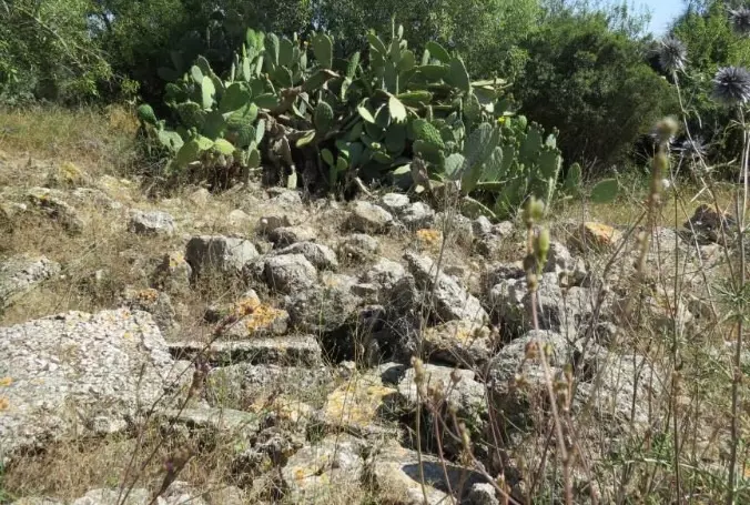
Village Before NakbaThe village was situated in a flat area on the central coastal plain, less than 4 km northeast of the Ramla-Jerusalem highway. Paths linked it to neighboring villages, especially 'Innaba, from which secondary roads led to Ramla, either directly or via the Ramla-Jerusalem highway. Some of the village lands were covered by forests, comprised mainly of oak and carob (kharrub in Arabic) trees. (The village name was probably a reference to the carob trees.) The French traveler Guérin, who visited Palestine several times in the mid-nineteenth century, described Kharruba as a hamlet , and it was later classified as a hamlet by the Mandate-era Palestine Index Gazetteer. Its adobe houses, closely packed together in no particular pattern, were separated by narrow alleys. Its population was predominantly Muslim. The residents purchased basic staples from the marketplaces of surrounding villages, where they also sold their goods. Kharruba's economy expanded toward the end of the Mandate and house-building increased. The villagers cultivated grain, vegetables, and fruits. Fruit groves were concentrated along the northeast and southwest sides of the village. In 1944/45 a total of 1,629 dunums was allocated to cereals; 25 dunums were irrigated or used for orchards.Village Occupation and Ethnic CleaningThe Israeli army's Yiftach Brigade reported on 10 July 1948 that its units had occupied Kharruba, blowing up houses and 'cleaning up' the village in the process. The next day the Yiftach units received orders 'to dig in in every place captured and to destroy every house not intended for occupation [by Israeli troops].' Israeli historian Benny Morris relates that these tasks were carried out as part of Operation Dani (see Abu al-Fadl, Ramla sub-disctrict), in which a force of almost four brigades moved to encircle and occupy the towns of Lydda and Ramla and their surrounding villages.Zionists Colonies on Village LandsThere are no Israeli settlements on village lands.Village TodayThe site is covered with the stone rubble of the destroyed houses, overgrown with vegetation. Many of the plants that grow on the site are ones that Palestinians traditionally planted near their homes: cactuses, castor oil (ricinus) plants, and cypress, Christ's-thorn, and olive trees. The surrounding land is used by Israelis as a grazing ground.SourceDr. Walid al-Khalidi, 1992: All That Remains. |
|||||||||||||
| Related Maps | Town Lands' Demarcation Maps خرائط للقضاء توضح حدود القرى والاودية Town's map on MapQuest View from satellite Help us map this town at WikiMapia |
||||||||||||
| Related Links | Wikipedia's Page Google Search Google For Images Google For Videos |
||||||||||||
| More Information | في كتاب كي لا ننسى في كتاب بلادنا فلسطين المزيد من موقع هوية |
||||||||||||
Want to browse more? 80,000 pictures were grouped in these gallaries:
| Display Name | Clan/Hamolah | Country of Residence |
No links have been shared yet, be free to the first to share the first link.


