| PalestineRemembered | About Us | Oral History | العربية | |
| Pictures | Zionist FAQs | Haavara | Maps | |
| Search |
| Camps |
| Districts |
| Acre |
| Baysan |
| Beersheba |
| Bethlehem |
| Gaza |
| Haifa |
| Hebron |
| Jaffa |
| Jericho |
| Jerusalem |
| Jinin |
| Nablus |
| Nazareth |
| Ramallah |
| al-Ramla |
| Safad |
| Tiberias |
| Tulkarm |
| Donate |
| Contact |
| Profile |
| Videos |
Welcome To Bayt 'Affa - بيت عفا (בית עפא)
|
District of Gaza
Ethnically cleansed days ago |
العربية Google Earth |
 |
Gallery (8) |
- Statistics & Facts
-
Before & After

- Satellite View
- Articles 3
- Pictures 8
- Aerial Views 1
- Oral History 3
- Members 8
- Families
- All That Remains
- Wikipedia
- Videos 1
- Guest Book 9
- Links
| Statistic & Fact | Value | ||||||||||||||
| Occupation Date | January 10, 1948 | ||||||||||||||
| Distance From District | 29 (km) North East of Gaza | ||||||||||||||
| Elevation | 100 (meters) | ||||||||||||||
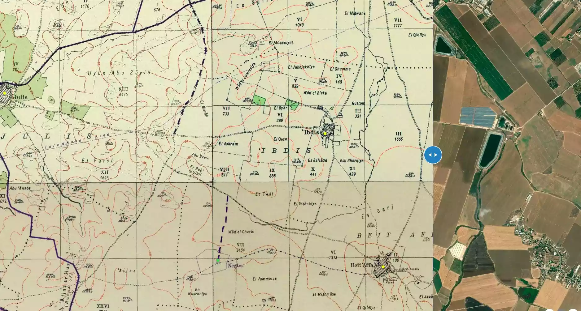
| Before & After Nakba, Click Map For Details |
|||||||||||||||
|
|||||||||||||||
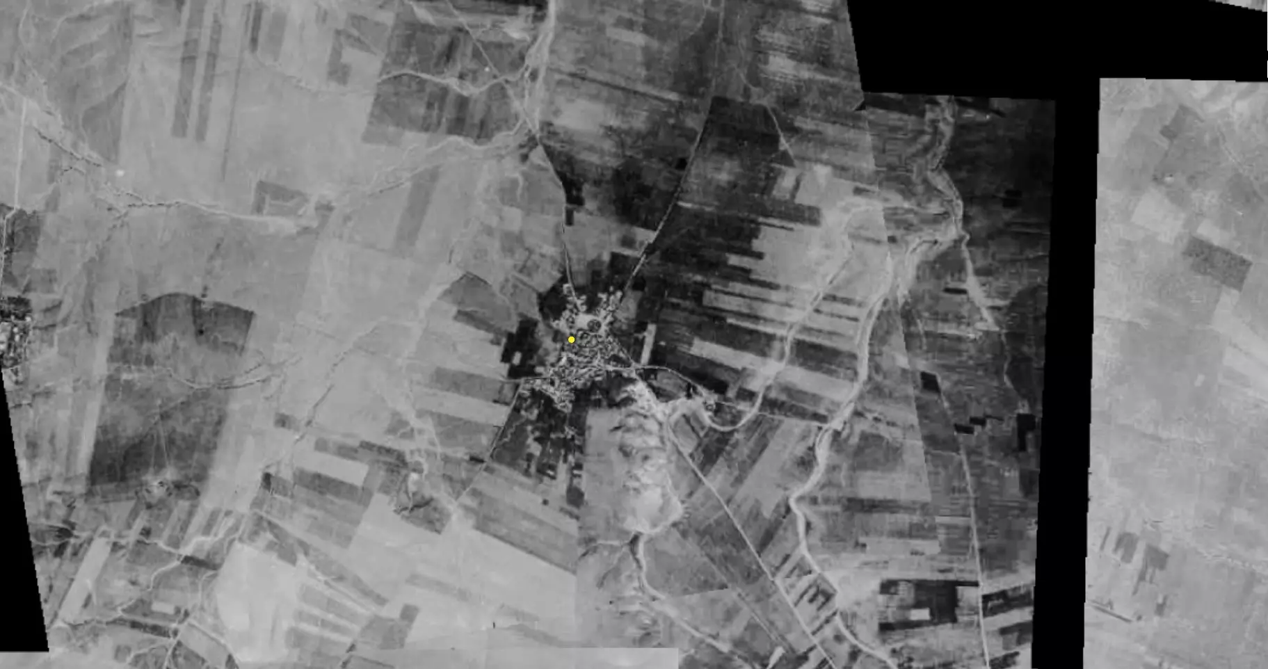
| Pre-Nakba Aerial View |
|||||||||||||||
|
|||||||||||||||
| Map Location | See location #22 on the map View from satellite |
||||||||||||||
| Military Operation | Operation Barak (lightening) | ||||||||||||||
| Attacking Units | Giv'ati Brigade's Second Battalion | ||||||||||||||
| Defenders | Egyptian and Sudanese soldiers | ||||||||||||||
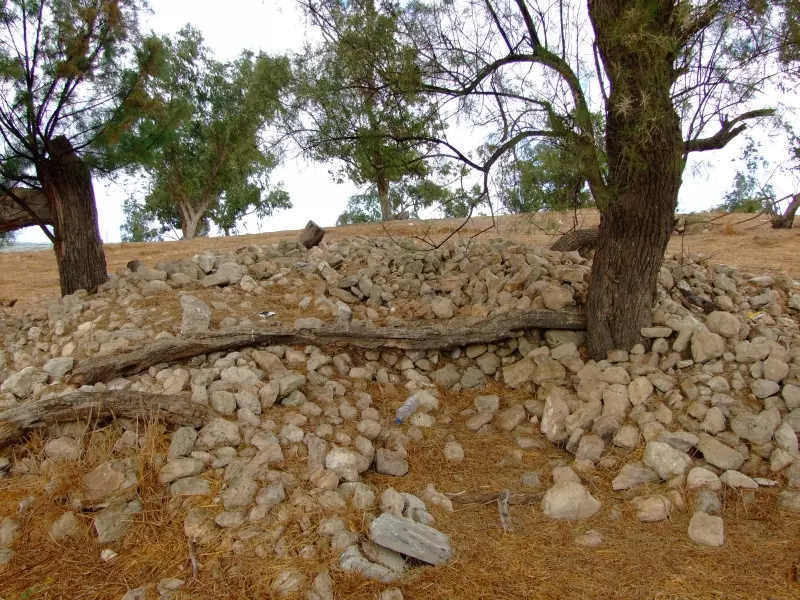
| Village Temains | The village was completely obliterated | ||||||||||||||
| Ethnically Cleansing | Bayt 'Affa inhabitants were completely ethnically cleansed. | ||||||||||||||
| Pre-Nakba Land Ownership |
|
||||||||||||||
| Land Usage As of 1945 |
|
||||||||||||||
| Population |
|
||||||||||||||
| Number of Houses |
|
||||||||||||||
| Near By Towns |
|||||||||||||||
|
|||||||||||||||
| Shrines / Maqams | Bayt 'Affa had a shrine for the Arab prophet (al-Nabi) Salih. | ||||||||||||||
| Nearby Wadies & Rivers | Wadi al-Rana ran just East of the village. | ||||||||||||||
| Archeological Sites | The village had a khirba which contained the remains of walls made of uncut stones, a well, and ancient columns. | ||||||||||||||
| Exculsive Jewish Colonies Who Usurped Village Lands |
Yad Natan | ||||||||||||||
| Featured Video | |||||||||||||||
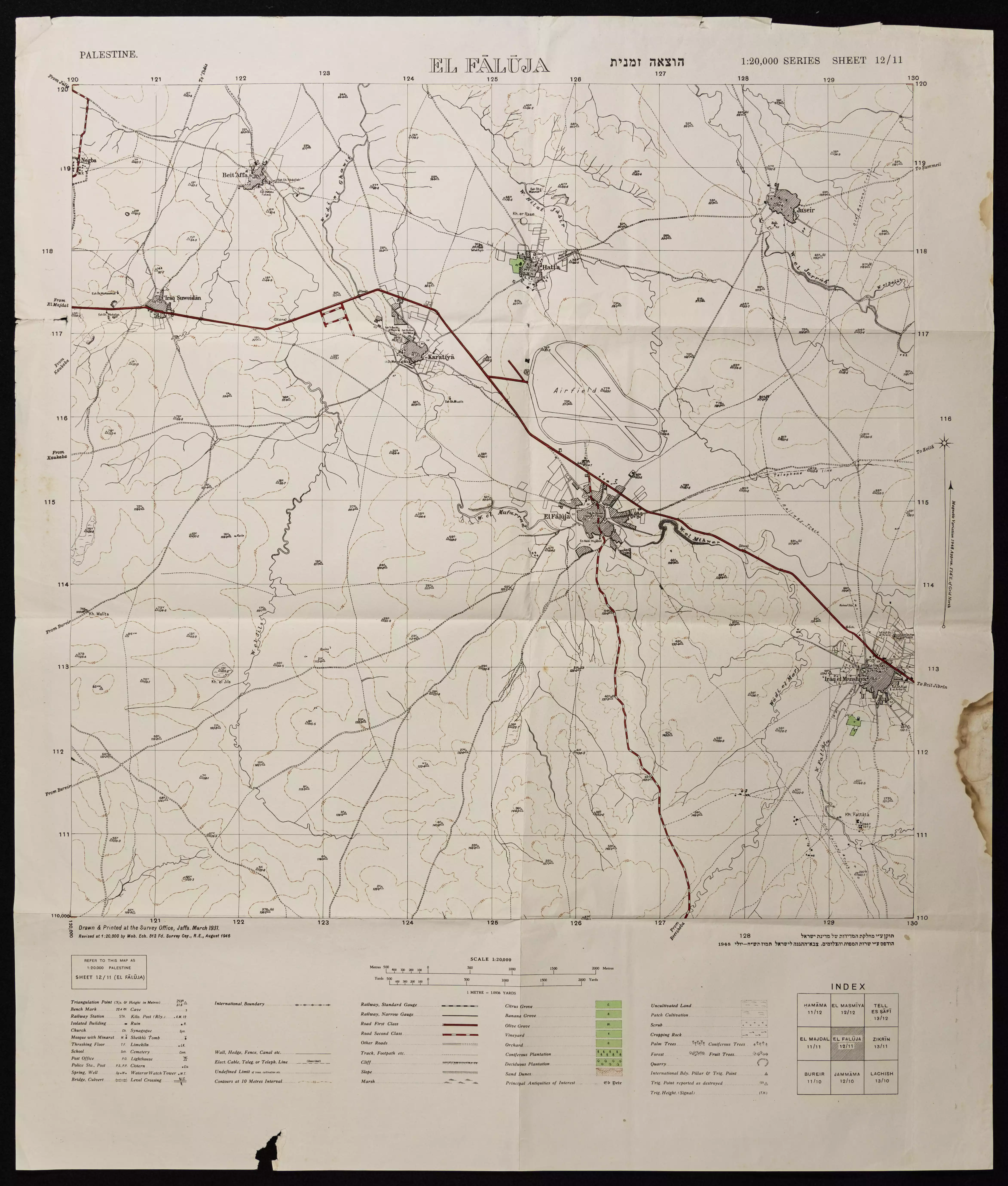
Village Before NakbaThe village stood on a small hill in a slightly elevated area adjacent to the coastal plain. Secondary roads linked it to two highways, one to the north and the other to the south, that led to al-Majdal on the coastal highway. Bayt Affa was the residence of the Sufi master al-Faluji―who migrated to Palestine from Iraq in the fourteenth century―before he moved to what was to become al-Faluja. In 1596, Bayt affa was a village in the nahiya of Gaza (liwa' of Gaza), with a population of 143. It paid taxes on a number of crops, including wheat, barley, and fruit, as well as on other types of produce and property, such as goats, beehives, and vineyards.In the late nineteenth century, Bayt Affa was a moderate-sized village built of adobe brick. The people of Bayt Affa were Muslims and maintained a shrine for a man whom they believed to be the Muslim prophet Salih. According to the Qur'an (suras al-A'raf, al-Qamr, and al-Shu'ara' ), Salih preached to the peoples of northwestern Arabia in ancient times. There was another, major shrine for Salih in the city of Ramla. The village relied on al-Faluja, a large village to the southeast, for commercial and educational services. Its inhabitants worked primarily in rainfed agriculture, cultivating grain and grapes. In 1944/45 a total of 5,657 dunums was allotted to cereals; 14 dunums were irrigated or used for orchards. Some villagers also bred animals, pasturing them on the rangeland between Bayt Affa and Kawkaba, to the southwest. Bayt Affa was built on the site of an ancient settlement. Archaeologists have noted a shrine and architectural fragments to the east, in Wadi al-Rana. A khirba lay on its land and contained the remains of walls made of uncut stone, a well, and columns Village Occupation and Ethnic CleaningAccording to a report in the Palestinian newspaper Filastin, a unit of Zionist militiamen penetrated into the outskirts of the village at midnight on 27 January 1948 and tried to mine some of the outlying houses. But the raiders were detected by village guards, who clashed with them for two hours, forcing them to withdraw to the settlement of Negba.There are divergent accounts of the occupation of Bayt Affa; the village seems to have changed hands at least twice during the course of the war. Israeli historian Benny Morris writes that it was occupied on 14-15 July 1948, during the period known as the Ten Days between the two truces of the war. According to Morris, it was overrun by units of the Giv'ati Brigade in the second phase of an offensive which extended the brigade's area of control southwards to the approaches to the Negev. This agrees with a New York Times report that stated it was occupied on 15 July. However, the History of the War of Independence states that the village was already in Israeli hands on 9 July, as the first truce ended. Held by a platoon of the Giv'ati Brigade's Second Battalion, it was captured by the Egyptian army on that date after applying 'pressure which lasted the whole morning.' The Haganah account states that Giv'ati's Fourth Battalion tried and failed to reoccupy the village a week later on 17–18 July, although it had the assistance of a naval landing party. The account adds that 'the Egyptians were aware of the vital importance of the village, so they fortified it well.' However, Egyptian writer Muhammad Abd al-Mun'im states that the Israeli occupation took place two days later, during the night of 10–11 July, when the village was taken from Palestinian militiamen assigned to defend it. Abd al-Mun'im adds that regular Egyptian forces recaptured it the following morning (11 July). A report carried by the New York Times confirms this last account, stating that Bayt Affa was first seized by the Israelis on 9 July, along with Iraq Suwaydan and Ibdis, and that it was lost the following day to Arab forces. After that battle, the Israelis claimed to have killed 300 Egyptian and Sudanese soldiers and to have captured 200 others. Despite the slight discrepancy in the dates, the latter version, which states that the village was seized and lost by the Israelis during the Ten Days between the two truces, seems more reliable. Bayt Affa was probably recaptured by Israeli forces for the last time in the second half of October, during Operation Yoav. But the villagers are likely to have been displaced at the time of the first occupation. Zionists Colonies on Village LandsThe settlement of Yad Natan was established close to the village site in 1953 on the land of Iraq Suwaydan, northwest of Bayt Affa.Village TodayThere are no traces of village houses; only sycamore and carob trees and cactuses mark the site. Fruit trees, especially citrus, are planted on the surrounding land and are irrigated from the Jordan River diversion canal.SourceDr. Walid al-Khalidi, 1992: All That Remains. |
|||||||||||||||
| Related Maps | Town Lands' Demarcation Maps خرائط للقضاء توضح حدود القرى والاودية Town's map on MapQuest View from satellite Help us map this town at WikiMapia |
||||||||||||||
| Related Links | Wikipedia's Page Google Search Google For Images Google For Videos |
||||||||||||||
| More Information | في كتاب كي لا ننسى في كتاب بلادنا فلسطين المزيد من موقع هوية |
||||||||||||||
- Village Land In 1987
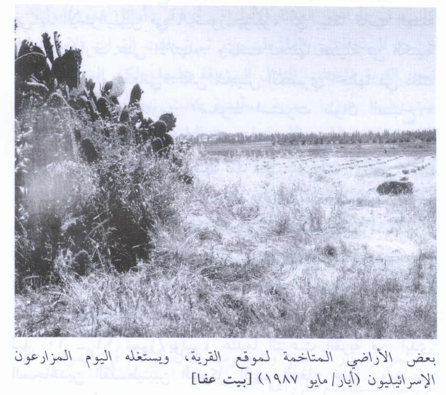
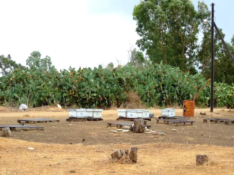
Scanned from "All That Remains" by Dr. Walid Khalidi 4 - Cacti and beehives on the village site 27/09/08
Posted by Uri Zackhem 2 - Tamarisk and rubble, 27/09/08
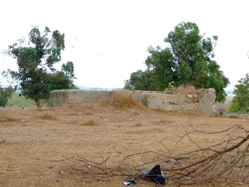
Posted by Uri Zackhem 2 - The only remaining structure: a well and irrigation pool, 27/09/08
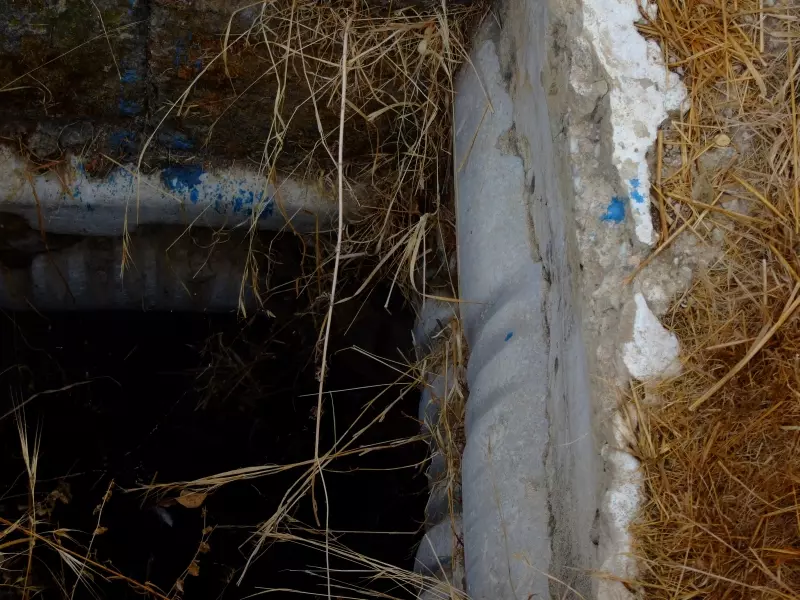
Posted by Uri Zackhem - Note the rope marks on the well sides, 27/09/08
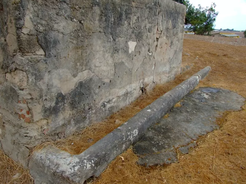
Posted by Uri Zackhem - A drinking trough by the well, 27/09/08
Posted by Uri Zackhem - Pre-Nakba Aerial view of the village / صورة من الجو للقرية اخذت قبل النكبة
- خارطة تُظهِر الحدود والطرق بأنواعها والأماكن المقدسة والطبيعة الطوبغرافية من تلال وسهول ومنحدرات والتشكيلة الطبيعية للأرض وأنواع المزروعات. نُشرت الخريطة فترة الانتداب البريطاني، تم إضافة تعديلات عليها من قِبَل خدمة الخرائط والصور التابعة للقوات العسكرية الاسرائيلية فترة الأربعينيات.
Want to browse more? 80,000 pictures were grouped in these gallaries:
| Display Name | Clan/Hamolah | Country of Residence |
| صلاح عبدالله ابوكف | ابوكف | مادبا |
| عبدالله صالح ابوكف | ابوكف | مادبا |
| عائدون | النجار | عمان, عمان |
| احمد النجار | النجار | عمان, الاردن |
| عفاوي | وشاح | غزة |
| مارشال | - | - |
| نبيل النجار | النجار | - |
| خليلية | خليلية | جبع |
No links have been shared yet, be free to the first to share the first link.
 Fake Valor: Why Did Zionist Jews Hoist Nazis Flag on Their Ships in the 1930s?
What is new?
-
Facts About Oct. 7th Gaza Raid
-
Remined Us Please:: Who Did Rape Who? Palestinians Raped Israelis? Or, was the other way around?
-
When Prof. Edward Said was invited to debate Bibi Netanyahu in the 1980s, watch what happened!
-
Ezra Klein of the NY Times on the "Jewish Race".
-
Abusing Blood Libel!
-
Did Israeli Soldiers Activate The Hanniba Direective On Oct. 7th? You Be The Judge
-
Zionist FAQ: Isn't it true that Palestinians don't want peace? Palestinians never accepted the two-state solution
- Facts about Haavara (Transfer) Agreement between Ben-Gurion & Hitler
-
Haavara FAQs: Why Did Zionist Jews Hoist Nazis' Flags on Their Ships in the 1930s?
- Haavara FAQs: When Chaim Weizmann met FDR in mid-1943, why was he silent about rescuing European Jewry?
-
Dear ChatGPT: How did Palestinians resist Napoleon's invasion of their country in 1799?
-
Dear ChatGPT: Gaza had a vibrant Jewish community in the mid-17th century. What happened to them?
-
Dear ChatGPT: Why did the Jewish Agency suppress news of the Holocaust during WWII?
-
Video Playlist: Jews share their DNA tests to end the conflict for good.
-
A Tale of Two Conflicts: Examining the Definition of Genocide
-
Prof. Abraham Polak And The Suppressed History of the Khazars and European Jewry
-
How Ronald Reagan would have framed the genocide in Gaza if he were still alive?
-
Haavara FAQs: Let us do the math: how many German Jews did The Haavara Agreement save?
-
Zionist FAQs: The Hebron Massacre of 1929, "clearly proves" that Palestinians are antisemitic, how could you deny it?
-
Zionist FAQs: Why Anti-Zionist Is Not Antisemitism?
-
Zionist FAQs: Isn't it true that the KGB created Palestinian Nationalism in the early 1960s?
- Zionist FAQs: Muslims are killing Muslims all the time; why are Israeli Jews being singled out in the media?
- Zionist FAQs: How is Israel an apartheid state when 20% of its citizens are Arabs who enjoy full rights?
-
Haavara FAQs: Why Did Dorothy Thompson Flip From A Zionist Advocate to A Silenced Dissenter?
-
Haavara FAQs: Analysis of Herzl's Uganda Scheme and how it could have saved millions of Jews.
-
Haavara FAQs: Why did Hayim Greenberg describe American Jewry as "morally bankrupt" in early 1943?
-
Haavara FAQs: What if the Evian Conference was a resounding success? What would have been the impact of saving European Jewry on Zionism?
- Haavara FAQs: What if the six million were saved, how that would have impacted the Zionist project?
-
Haavara FAQs: How did Zionist leaders react when Europe's Jews lingered in the DP camps after WWII ended?
-
Why does the American Jewish community repeat lies that David Ben-Gurion had debunked before he died?
-
Who has the power to rename the Tatar/Khazar Gene Marker to Jewish IV?
-
Zionist FAQs: Why won't Egypt, Syria, and Jordan take their people back? Jews are indigenous to Palestine, and Arabs immigrated after Jews developed the country. Arabs should leave.
-
Haavara FAQs: Did Hitler and the Nazis conflate between Judaism and Zionist? If that wasn't case, then why?
-
Haavara FAQs: Winston Churchill and antisemitism, a collection of articles written Churchill.
-
Haavara FAQs: Broken by country, how many Jews survived vs. killed during the Holocaust?
-
Haavara FAQs: Why did European Jews vote with their feet and to immigrated to the Americas, not Palestine, after WWII?
-
Watch this American Jewish Girl describing Israeli Jews' cognitive dissonance like no other in under two minutes
-
Haavara FAQs: When the Nazis went out of their way to hide the Holocaust, Israeli Jews did the exact opposite by broadcasting their genocide of Gazans. But why?
-
Haavara FAQs: How Zionist Jews went out of their to show their appreciation to Nazism and Fascism?
- Haavara FAQs: Why Zionist leaders were against bombing the death camps & the Railroads leading to them?
-
Haavara FAQs: Hitler's message to the British and American people: If Jews are such noble citizens and you care about them, how come you're not letting them in? I will gladly ship them to you at my expense, even on luxury liners!
-
A shortlist of Zionist and Israeli false flag operations in the name Jews.
-
The Most Moral Army
- The Land of Kapos (Israel): Where the brave are boycotted and Kapos walk free.
- Why did early Zionists often named their communal enterprises "colonial"?
- Zionist Relations with Nazi Germany by Faris Glubb
-
Two NY Times advertisements by Zionists in the early 1943 that exposes Zionists' treason at the height of the calamity
- Facts Not Lies about the Palestinian-Israeli Conflict.
- Site's pictures have been categorized
- Campgain Against Lice
- A Survey of Palestine, the official source about Palestine before Nakba produced by the British Mandate; over 1200 pages.
- Satellite View & Google Earth: Over 6,000 placemarks identifying all destroyed towns, W. Bank & Gaza Strip Towns, & refugee camps.
- PalestineRemembered.com and its Nakba Oral History Project were featured on al-Jazeera Satellite TV.
- Nakba Oral History Video Podcast:
 Over 700 Oral History interviews (including 3,500+ hours of recording) can be viewed online.
 - Palestine Village Statistics Project
- Gaza Jail Break
- النسخة العربية للموقع الان متوفرة
- Videos: Documenting the destroyed villages in video: Tracing all that remains since Nakba.
- Videos: Responding to Zionist Propaganda
- Interview: The ethnic cleansing of Palestine: George Galloway interviews Israeli Historian Ilan Pappe.
- For Palestinians, memory matters. It provides a blueprint for their future By George Bisharat.
- Zionist FAQ now available in Hebrew שאלות שציונים שואלים, עכשיו בעברית
- Video: The Stephen Walt and John Mearsheimer report on the influence of the Israel Lobby on U.S. Foreign Policy
- The Palestinian-Israeli conflict for beginners
