| PalestineRemembered | About Us | Oral History | العربية | |
| Pictures | Zionist FAQs | Haavara | Maps | |
| Search |
| Camps |
| Districts |
| Acre |
| Baysan |
| Beersheba |
| Bethlehem |
| Gaza |
| Haifa |
| Hebron |
| Jaffa |
| Jericho |
| Jerusalem |
| Jinin |
| Nablus |
| Nazareth |
| Ramallah |
| al-Ramla |
| Safad |
| Tiberias |
| Tulkarm |
| Donate |
| Contact |
| Profile |
| Videos |
Welcome To Karatiyya - كرتيا (כרתיא)
|
District of Gaza
Ethnically cleansed days ago |
العربية Google Earth |
| Gallery (5) |
- Statistics & Facts
-
Before & After

- Satellite View
- Articles 1
- Pictures 5
- Aerial Views 1
- Oral History 2
- Members 11
- All That Remains
- Town's Map
- Wikipedia
- Videos 2
- Guest Book 11
- Links 1
| Statistic & Fact | Value | ||||||||||||||
| Occupation Date | July 17, 1948 | ||||||||||||||
| Distance From District | 29 (km) North East of Gaza | ||||||||||||||
| Elevation | 100 (meters) | ||||||||||||||
| Before & After Nakba, Click Map For Details |
|||||||||||||||

|
|||||||||||||||
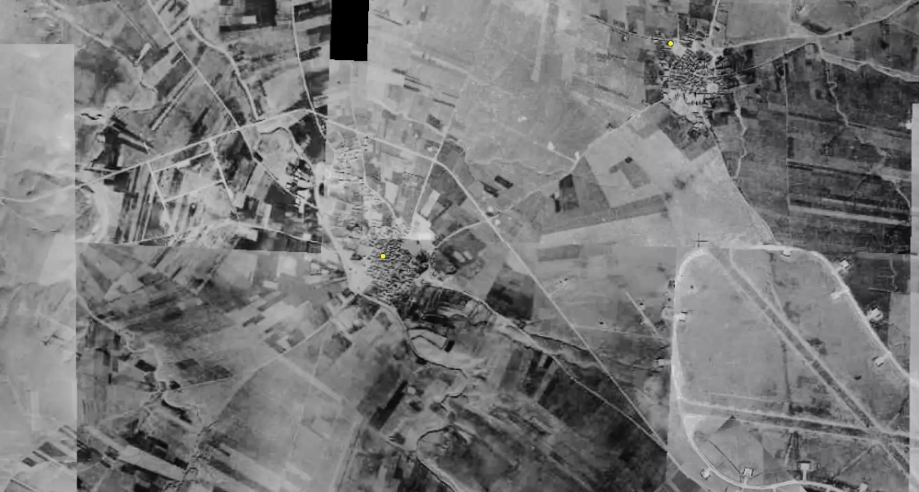
| Pre-Nakba Aerial View |
|||||||||||||||

|
|||||||||||||||
| Map Location | See location #26 on the map View from satellite |
||||||||||||||
| Military Operation | Either Operation Barak or Operation Ya'ov | ||||||||||||||
| Attacking Units | Third Battalion of the Giv'ati Brigade and the Ninth Commando Battalion of the Armored Brigade. | ||||||||||||||
| Defenders | Egyptian Army | ||||||||||||||
| Exodus Cause | Military assault by Zionist troops | ||||||||||||||
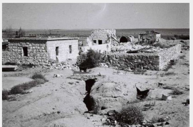
| Village Temains | The village was completely destroyed and only house rubble left behind. | ||||||||||||||
| Ethnically Cleansing | Karatiyya inhabitants were completely ethnically cleansed. | ||||||||||||||
| Pre-Nakba Land Ownership |
**Town Lands' Demarcation Maps |
||||||||||||||
| Land Usage As of 1945 |
|
||||||||||||||
| Population |
|
||||||||||||||
| Number of Houses |
|
||||||||||||||
| Near By Towns |
|||||||||||||||
|
|||||||||||||||
| Town's Name Through History | The Crusades built in Karatiyya a castle which was known by Galatie, from which it may have picked its name from. | ||||||||||||||
| Schools | Karatiyya had an elementary school for boys which was founded in 1922, and in 1945 it had an enrollment of 128 students. | ||||||||||||||
| Places of Warship | One mosque | ||||||||||||||
| Nearby Wadies & Rivers | Wadi al-Mufrid bordered the village from the east. | ||||||||||||||
| Archeological Sites | Karatiyya contained number of khirbats dating from the days of the Mamluks and the Crusades periods. | ||||||||||||||
| Exculsive Jewish Colonies Who Usurped Village Lands |
Qomemiyyut, Nehora, and Rewacha. | ||||||||||||||
| Featured Video | |||||||||||||||
Village TodayAccording to the Palestinian historian Walid Khalidi, the village remaining structures on the village land are:"Piles of debris are scattered on the site, and a destroyed cemetery (partially hidden among eucalyptus trees) can be seen. An agricultural road runs through it." |
|||||||||||||||
| Related Maps | Town Lands' Demarcation Maps خرائط للقضاء توضح حدود القرى والاودية Town's map on MapQuest View from satellite Help us map this town at WikiMapia |
||||||||||||||
| Related Links | Wikipedia's Page Facebook Page Google Search Google For Images Google For Videos |
||||||||||||||
| More Information | مخطط البلد في كتاب كي لا ننسى المزيد من موقع هوية |
||||||||||||||
- Village Rubble In 1987
Scanned from "All That Remains" by Dr. Walid Khalidi 6 - مخطط قرية كرتيا قبل النكبة، إعداد محمد وناهد مغازي
2 - قريه كرتيا بعد احتلالها
Posted by abu raya - Pre-Nakba Aerial view of the village / صورة من الجو للقرية اخذت قبل النكبة
- خارطة تُظهِر الحدود والطرق بأنواعها والأماكن المقدسة والطبيعة الطوبغرافية من تلال وسهول ومنحدرات والتشكيلة الطبيعية للأرض وأنواع المزروعات. نُشرت الخريطة فترة الانتداب البريطاني، تم إضافة تعديلات عليها من قِبَل خدمة الخرائط والصور التابعة للقوات العسكرية الاسرائيلية فترة الأربعينيات.
Want to browse more? 80,000 pictures were grouped in these gallaries:
| Display Name | Clan/Hamolah | Country of Residence |
| هيام جوده | جوده | الامارات, الامارات |
| مؤنس فروانه | فروانه | - |
| khaled isamil almghari | المغاري | dair elbalah |
| فارس فلسطين | المغاري | كرتيا |
| الحميدي | الحميدي | غزة, فلسطين |
| Ahmed Abu Saada | أبو سعده | MO, USA |
| Abu Tareq | الخالدي | - |
| طلال | ارشيد | - |
| ابو عبدالله ابو لمظي | ابو لمظي | غزة, فلسطين |
| akram abahre | عباهره | - |
| Hasan Fayyad | Fayyad | - |
- برنامج شاهد على النكبة الحلقة الأولى - كرتيا Duration: 6 min 54 sec
- الذاكرة مفتاح العودة--الحلقة 38- قرية كرتيا Duration: 23 min 22 sec


