| PalestineRemembered | About Us | Oral History | العربية | |
| Pictures | Zionist FAQs | Haavara | Maps | |
| Search |
| Camps |
| Districts |
| Acre |
| Baysan |
| Beersheba |
| Bethlehem |
| Gaza |
| Haifa |
| Hebron |
| Jaffa |
| Jericho |
| Jerusalem |
| Jinin |
| Nablus |
| Nazareth |
| Ramallah |
| al-Ramla |
| Safad |
| Tiberias |
| Tulkarm |
| Donate |
| Contact |
| Profile |
| Videos |
Welcome To al-Batani al-Gharbi - البطاني الغربي (אל-בטאני אל-ע'רבי)
|
District of Gaza
Ethnically cleansed days ago |
العربية Google Earth |
 |
Gallery (7) |
- Statistics & Facts
-
Before & After

- Satellite View
- Articles 1
- Pictures 7
- Aerial Views 1
- Members 9
- All That Remains
- Wikipedia
- Videos 1
- Guest Book 2
- Links 1
| Statistic & Fact | Value | ||||||||||||||
| Occupation Date | May 13, 1948 | ||||||||||||||
| Distance From District | 36 (km) North East of Gaza | ||||||||||||||
| Elevation | 25 (meters) | ||||||||||||||
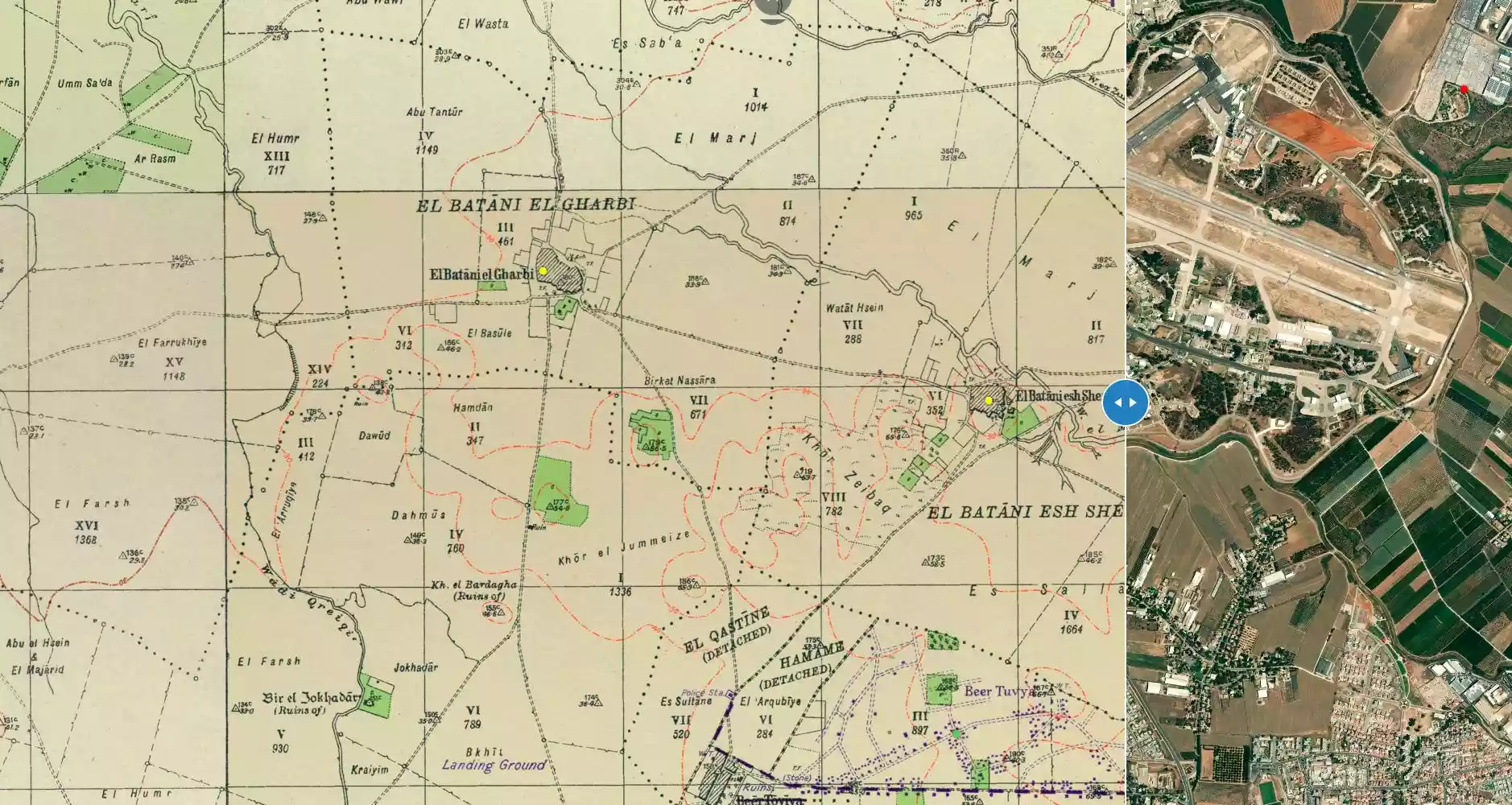
| Before & After Nakba, Click Map For Details |
|||||||||||||||
|
|||||||||||||||
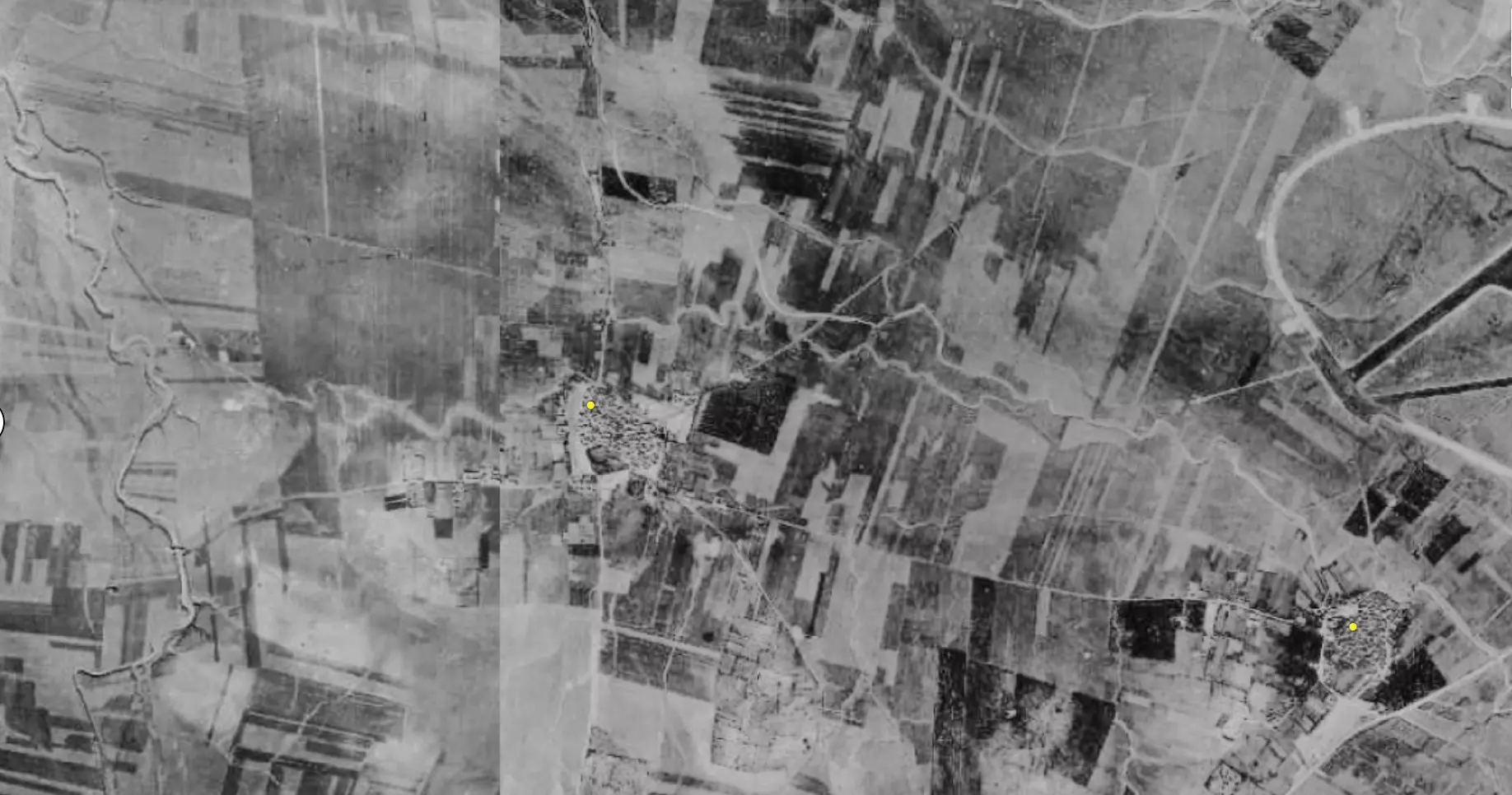
| Pre-Nakba Aerial View |
|||||||||||||||
|
|||||||||||||||
| Map Location | See location #5 on the map View from satellite |
||||||||||||||
| Military Operation | Operation Barak (lightening) | ||||||||||||||
| Attacking Units | Giv'ati Brigade | ||||||||||||||
| Exodus Cause | Military assault by Zionist troops | ||||||||||||||
| Village Temains | The village was completely obliterated. | ||||||||||||||
| Ethnically Cleansing | al-Batani al-Gharbi inhabitants were completely ethnically cleansed. | ||||||||||||||
| Pre-Nakba Land Ownership |
|
||||||||||||||
| Land Usage As of 1945 |
|
||||||||||||||
| Population |
|
||||||||||||||
| Number of Houses |
|
||||||||||||||
| Near By Towns |
|||||||||||||||
|
|||||||||||||||
| Schools | al-Batani al-Gharbi had an elementary school for boys founded in 1947, and it had an initial enrollment of 119 students. It should be noted that students from the nearby villages of Barqa and al-Batini al-Sharqi used to attend the same school too. | ||||||||||||||
| Places of Warship | One mosque | ||||||||||||||
| Exculsive Jewish Colonies Who Usurped Village Lands |
No settlements on village land. | ||||||||||||||
| Featured Video | |||||||||||||||
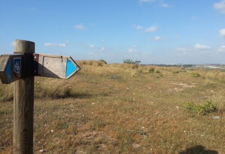
Village Before NakbaThe village stood on flat terrain on the southern coastal plain. It was one of two villages named al-Batani. Its twin, al-Batani al-Sharqi, lay to the east. The names of the two villages identified one as 'eastern' (sharqi) and the other as 'western' (gharbi). A military airport was built during the Mandate on flat land about 2 km south of the village. Secondary roads linked al-Batani al-Gharbi to adjacent villages, including Yasur and Isdud on the coastal highway. The earliest available reference to al-Batani indicates that it was originally founded as a 'ranch' for the first Umayyad caliph, Mu'awiya ibn Abi Sufyan (A.D. 661–680)In the late nineteenth century, the village of al-Batani al-Gharbi was situated on low ground and had a rectangular shape, extending along a southeast–northwest line. Construction initially expanded along the two short sides of the rectangle, then along the roads to other villages. The village houses, made of adobe brick with wood and cane roofs, were built close together, separated by narrow alleys. Along with a pond and a few wells, scattered patches of garden could be seen on the village lands. The two al-Batanis shared an elementary school that was opened in 1947 with an initial enrollment of 119 students. The population was Muslim, and the village had its own mosque as well as a number of small shops. The villagers worked mainly in agriculture, cultivating, among other crops, grain and citrus. In 1944/45 a total of 170 dunums was devoted to citrus and bananas and 4,152 dunums were allotted to cereals; 95 dunums were irrigated or used for orchards. Agriculture was both rainfed and irrigated from wells that were scattered across the landscape. These wells also supplied water for domestic use. In addition to crop cultivation, the community engaged in animal husbandry and poultry raising Village Occupation and Ethnic CleaningAl-Batani al-Gharbi was one of four villages occupied on 18 May 1948 during the second stage of Operation Barak. It was occupied a few days after the fall of al-Batani al-Sharqi. Israeli historian Benny Morris states that 'most of the inhabitants of these villages had fled either before or during the attack; a few were probably expelled.'Zionists Colonies on Village LandsThere are no Israeli settlements on village land. The settlement of Azriqam, established in 1950, is close to the village site, to the south, on the land of Bayt Daras.Village TodayCactuses and fig and sycamore trees grow on the site, and some of the village streets are still clearly recognizable. The adjacent land is partially cultivated by the nearby kibbutz. A stone quarry is also located on village lands.SourceDr. Walid al-Khalidi, 1992: All That Remains. |
|||||||||||||||
| Related Maps | Town Lands' Demarcation Maps خرائط للقضاء توضح حدود القرى والاودية Town's map on MapQuest View from satellite Help us map this town at WikiMapia |
||||||||||||||
| Related Links | Wikipedia's Page Google Search Google For Images Google For Videos |
||||||||||||||
| More Information | في كتاب كي لا ننسى في كتاب بلادنا فلسطين المزيد من موقع هوية |
||||||||||||||
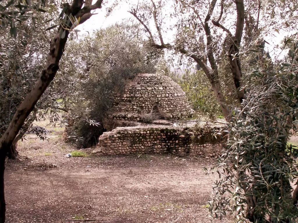
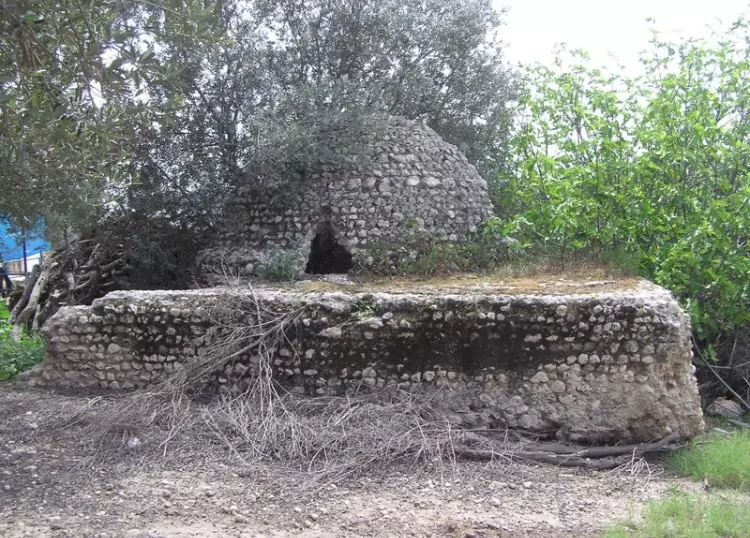
- A domed building (a shrine?). It is made of local sandstone bricks and cemented with a lot of shells in the cement. It is in Moshav Azrikam. I've seen no other buildings.
Posted by Uri Zackhem 6 - من موقع القريه
Posted by abu raya - موقع القريه ومقام الشيخ يوسف
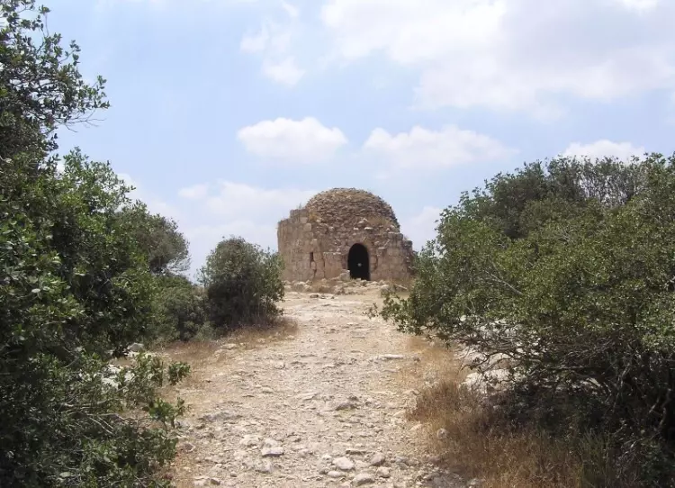
Posted by abu raya - مقام الشيخ يوسف في القريه
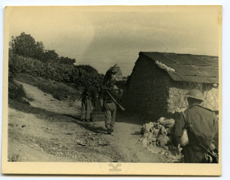
Posted by abu raya - صورة نادرة عقب دخول اليهود البلد و نهب الحلال 1948 -1
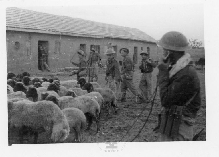
Posted by أبو اليزن السعافين - صورة نادرة عقب دخول اليهود البطاني و نهب الحلال 1948 -1
Posted by أبو اليزن السعافين - Pre-Nakba Aerial view of the village / صورة من الجو للقرية اخذت قبل النكبة
Want to browse more? 80,000 pictures were grouped in these gallaries:
| Display Name | Clan/Hamolah | Country of Residence |
| Sami | Hasanain | London, Canada |
| أحمد الدربي | الدربي | غزه |
| A Alnawajha | النواجحه | - |
| رزق أبورزق | النواجحة | - |
| نعيم الدويك | الدويك | - |
| أبو عبيدة | المدلل | غزة, فلسطين |
| Khaled Halabi | الحلبي | قطاع غزة, فلسطين |
| al-jub | al-jub | singl, jordan |
| Rushdi | KHALAF | ONTARIO , CANADA |
- في موقع قرية البطاني المهجرة (قضاء الر ملة ) Duration: min 56 sec
 Fake Valor: Why Did Zionist Jews Hoist Nazis Flag on Their Ships in the 1930s?
What is new?
-
Facts About Oct. 7th Gaza Raid
-
Remined Us Please:: Who Did Rape Who? Palestinians Raped Israelis? Or, was the other way around?
-
When Prof. Edward Said was invited to debate Bibi Netanyahu in the 1980s, watch what happened!
-
Ezra Klein of the NY Times on the "Jewish Race".
-
Abusing Blood Libel!
-
Did Israeli Soldiers Activate The Hanniba Direective On Oct. 7th? You Be The Judge
-
Zionist FAQ: Isn't it true that Palestinians don't want peace? Palestinians never accepted the two-state solution
- Facts about Haavara (Transfer) Agreement between Ben-Gurion & Hitler
-
Haavara FAQs: Why Did Zionist Jews Hoist Nazis' Flags on Their Ships in the 1930s?
- Haavara FAQs: When Chaim Weizmann met FDR in mid-1943, why was he silent about rescuing European Jewry?
-
Dear ChatGPT: How did Palestinians resist Napoleon's invasion of their country in 1799?
-
Dear ChatGPT: Gaza had a vibrant Jewish community in the mid-17th century. What happened to them?
-
Dear ChatGPT: Why did the Jewish Agency suppress news of the Holocaust during WWII?
-
Video Playlist: Jews share their DNA tests to end the conflict for good.
-
A Tale of Two Conflicts: Examining the Definition of Genocide
-
Prof. Abraham Polak And The Suppressed History of the Khazars and European Jewry
-
How Ronald Reagan would have framed the genocide in Gaza if he were still alive?
-
Haavara FAQs: Let us do the math: how many German Jews did The Haavara Agreement save?
-
Zionist FAQs: The Hebron Massacre of 1929, "clearly proves" that Palestinians are antisemitic, how could you deny it?
-
Zionist FAQs: Why Anti-Zionist Is Not Antisemitism?
-
Zionist FAQs: Isn't it true that the KGB created Palestinian Nationalism in the early 1960s?
- Zionist FAQs: Muslims are killing Muslims all the time; why are Israeli Jews being singled out in the media?
- Zionist FAQs: How is Israel an apartheid state when 20% of its citizens are Arabs who enjoy full rights?
-
Haavara FAQs: Why Did Dorothy Thompson Flip From A Zionist Advocate to A Silenced Dissenter?
-
Haavara FAQs: Analysis of Herzl's Uganda Scheme and how it could have saved millions of Jews.
-
Haavara FAQs: Why did Hayim Greenberg describe American Jewry as "morally bankrupt" in early 1943?
-
Haavara FAQs: What if the Evian Conference was a resounding success? What would have been the impact of saving European Jewry on Zionism?
- Haavara FAQs: What if the six million were saved, how that would have impacted the Zionist project?
-
Haavara FAQs: How did Zionist leaders react when Europe's Jews lingered in the DP camps after WWII ended?
-
Why does the American Jewish community repeat lies that David Ben-Gurion had debunked before he died?
-
Who has the power to rename the Tatar/Khazar Gene Marker to Jewish IV?
-
Zionist FAQs: Why won't Egypt, Syria, and Jordan take their people back? Jews are indigenous to Palestine, and Arabs immigrated after Jews developed the country. Arabs should leave.
-
Haavara FAQs: Did Hitler and the Nazis conflate between Judaism and Zionist? If that wasn't case, then why?
-
Haavara FAQs: Winston Churchill and antisemitism, a collection of articles written Churchill.
-
Haavara FAQs: Broken by country, how many Jews survived vs. killed during the Holocaust?
-
Haavara FAQs: Why did European Jews vote with their feet and to immigrated to the Americas, not Palestine, after WWII?
-
Watch this American Jewish Girl describing Israeli Jews' cognitive dissonance like no other in under two minutes
-
Haavara FAQs: When the Nazis went out of their way to hide the Holocaust, Israeli Jews did the exact opposite by broadcasting their genocide of Gazans. But why?
-
Haavara FAQs: How Zionist Jews went out of their to show their appreciation to Nazism and Fascism?
- Haavara FAQs: Why Zionist leaders were against bombing the death camps & the Railroads leading to them?
-
Haavara FAQs: Hitler's message to the British and American people: If Jews are such noble citizens and you care about them, how come you're not letting them in? I will gladly ship them to you at my expense, even on luxury liners!
-
A shortlist of Zionist and Israeli false flag operations in the name Jews.
-
The Most Moral Army
- The Land of Kapos (Israel): Where the brave are boycotted and Kapos walk free.
- Why did early Zionists often named their communal enterprises "colonial"?
- Zionist Relations with Nazi Germany by Faris Glubb
-
Two NY Times advertisements by Zionists in the early 1943 that exposes Zionists' treason at the height of the calamity
- Facts Not Lies about the Palestinian-Israeli Conflict.
- Site's pictures have been categorized
- Campgain Against Lice
- A Survey of Palestine, the official source about Palestine before Nakba produced by the British Mandate; over 1200 pages.
- Satellite View & Google Earth: Over 6,000 placemarks identifying all destroyed towns, W. Bank & Gaza Strip Towns, & refugee camps.
- PalestineRemembered.com and its Nakba Oral History Project were featured on al-Jazeera Satellite TV.
- Nakba Oral History Video Podcast:
 Over 700 Oral History interviews (including 3,500+ hours of recording) can be viewed online.
 - Palestine Village Statistics Project
- Gaza Jail Break
- النسخة العربية للموقع الان متوفرة
- Videos: Documenting the destroyed villages in video: Tracing all that remains since Nakba.
- Videos: Responding to Zionist Propaganda
- Interview: The ethnic cleansing of Palestine: George Galloway interviews Israeli Historian Ilan Pappe.
- For Palestinians, memory matters. It provides a blueprint for their future By George Bisharat.
- Zionist FAQ now available in Hebrew שאלות שציונים שואלים, עכשיו בעברית
- Video: The Stephen Walt and John Mearsheimer report on the influence of the Israel Lobby on U.S. Foreign Policy
- The Palestinian-Israeli conflict for beginners
