| PalestineRemembered | About Us | Oral History | العربية | |
| Pictures | Zionist FAQs | Haavara | Maps | |
| Search |
| Camps |
| Districts |
| Acre |
| Baysan |
| Beersheba |
| Bethlehem |
| Gaza |
| Haifa |
| Hebron |
| Jaffa |
| Jericho |
| Jerusalem |
| Jinin |
| Nablus |
| Nazareth |
| Ramallah |
| al-Ramla |
| Safad |
| Tiberias |
| Tulkarm |
| Donate |
| Contact |
| Profile |
| Videos |
Welcome To al-Batani al-Sharqi - البطاني الشرقي (אל-בטאני א-שרקי)
|
District of Gaza
Ethnically cleansed days ago |
العربية Google Earth |
 |
Gallery (7) |
- Statistics & Facts
-
Before & After

- Satellite View
- Articles 2
- Pictures 7
- Aerial Views 1
- Members 15
- All That Remains
- Wikipedia
- Videos
- Guest Book 4
- Links 1
| Statistic & Fact | Value | |||||||||||||||||||||
| Occupation Date | May 13, 1948 | |||||||||||||||||||||
| Distance From District | 36.5 (km) North East of Gaza | |||||||||||||||||||||
| Elevation | 50 (meters) | |||||||||||||||||||||
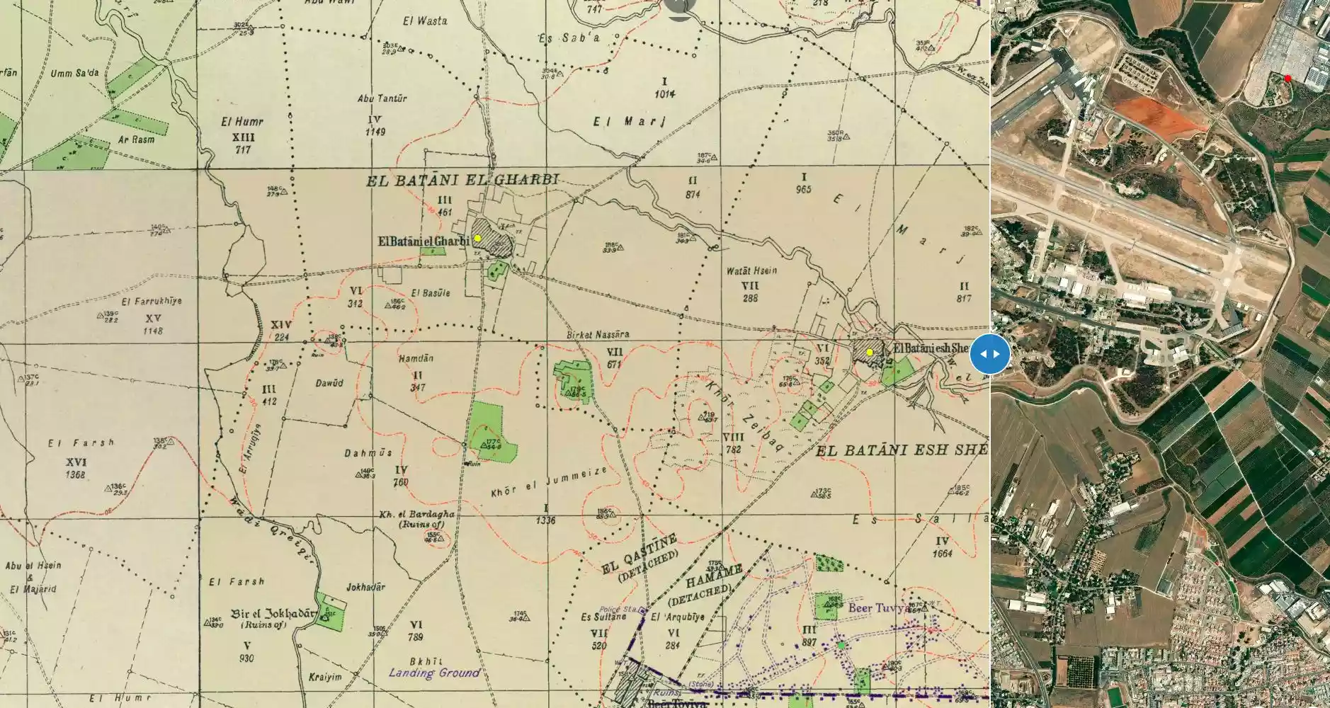
| Before & After Nakba, Click Map For Details |
||||||||||||||||||||||
|
||||||||||||||||||||||
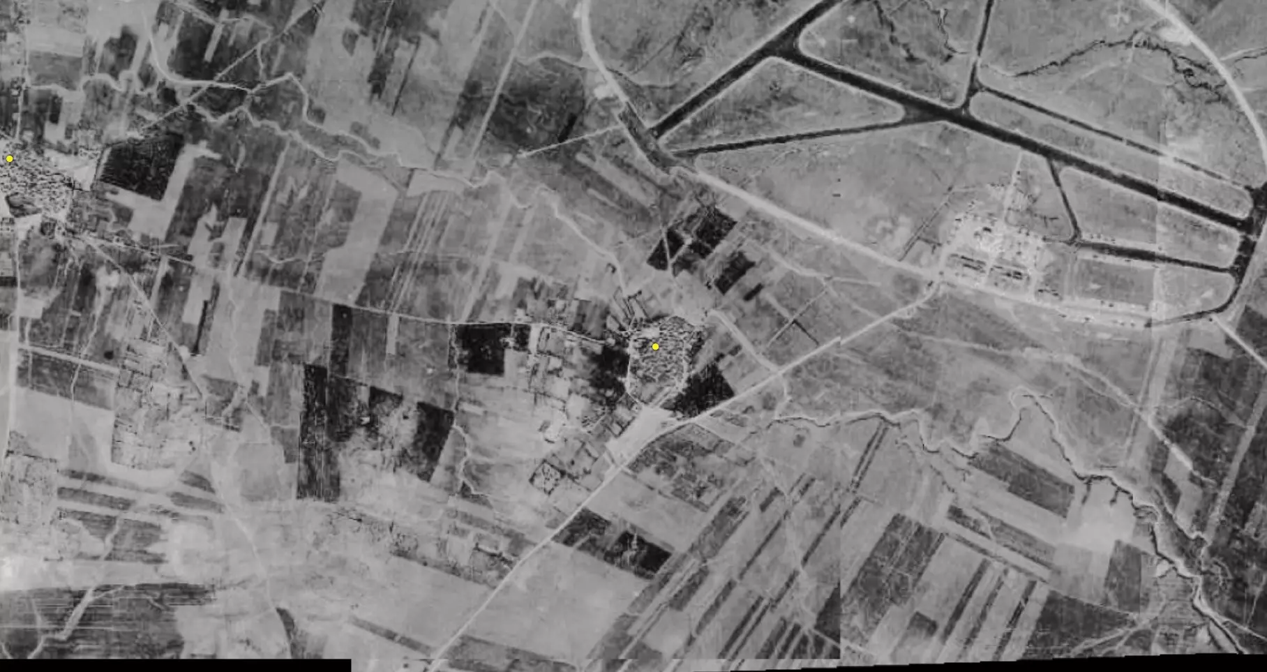
| Pre-Nakba Aerial View |
||||||||||||||||||||||
|
||||||||||||||||||||||
| Map Location | See location #6 on the map View from satellite |
|||||||||||||||||||||
| Military Operation | Operation Barak (lightening) | |||||||||||||||||||||
| Attacking Units | Eighth Battalion of Giv'ati Brigade | |||||||||||||||||||||
| Defenders | Egyptian Army, and some local Palestinian militia | |||||||||||||||||||||
| Exodus Cause | Military assault by Zionist troops | |||||||||||||||||||||
| Village Temains | The village was completely obliterated. | |||||||||||||||||||||
| Ethnically Cleansing | al-Batani al-Sharqi inhabitants were completely ethnically cleansed. | |||||||||||||||||||||
| Pre-Nakba Land Ownership |
|
|||||||||||||||||||||
| Land Usage As of 1945 |
|
|||||||||||||||||||||
| Population |
|
|||||||||||||||||||||
| Number of Houses |
|
|||||||||||||||||||||
| Near By Towns |
||||||||||||||||||||||
|
||||||||||||||||||||||
| Schools | al-Batani al-Sharqi shared an elementary school with it sister village al-Batini al-Gharbi. | |||||||||||||||||||||
| Places of Warship | One mosque | |||||||||||||||||||||
| Archeological Sites | The village contained relics such as a mosaic floor, a basin, the foundations of ancient buildings, and pottery fragments. | |||||||||||||||||||||
| Exculsive Jewish Colonies Who Usurped Village Lands |
No settlements on village lands. | |||||||||||||||||||||
Village Before NakbaThe village stood on flat terrain on the southern coastal plain and was bordered on the east by Wadi al-Mari. Secondary roads linked it to adjacent villages, such as Yasur and Isdud, on the coastal highway. A military airport was constructed near the village during the Mandate; it was built on flat land to the southwest of al-Batani al-Sharqi, due south of its twin village, al-Batani al-Gharbi. The earliest mention of al-Batani indicated that it was originally founded as a 'ranch' for the first Umayyad caliph, Mu'awiya ibn Abi Sufyan (A.D. 661–680) In 1596, al-Batani al-Sharqi was a village in the nahiya of Gaza (liwa' of Gaza) with a population of thirty-nine. It paid taxes on a number of crops, including wheat, barley, and fruit, as well as on other types of produce and property, such as goats, beehives, and vineyards.In the late nineteenth century, the village of al-Batani al-Sharqi was situated on low ground and extended from east to west in a rectangular shape. Patches of gardens and a number of wells surrounded the village. Construction expanded westward―the wadi's winter flooding impeded eastward expansion―along the road that linked it to al-Batani al-Gharbi until the distance between the two villages shrank to less than 2 km. Village houses, made of adobe, with wood-and-cane roofs, were built close together along narrow alleys. The two al-Batanis shared an elementary school that was opened in 1947; its initial enrollment was 119 students. The population was Muslim, and the village had a mosque and a number of small shops. The inhabitants worked mainly as grain and citrus farmers. In 1944/45 a total of 319 dunums was devoted to citrus and bananas and 4,663 dunums were allocated to cereals; 474 dunums were irrigated or used for orchards. Agriculture was both rainfed and irrigated from the many wells on the village land, which also supplied drinking water. In addition to crop cultivation, the community engaged in animal husbandry and poultry raising. An archaeological site in al-Batani al-Sharqi contained relics such as a mosaic floor, a basin, the foundations of ancient buildings, and pottery fragments. Village Occupation and Ethnic CleaningTogether with Bashshit and Barqa, the village was occupied by the Haganah's Giv'ati Brigade, just before the end of the British Mandate over Palestine (see al-Batani al-Gharbi, Gaza sub-disctrict). According to historian Benny Morris, al-Batani al-Sharqi fell under Israeli control on 13 May 1948, as Giv'ati expanded southwards in anticipation of an engagement with Egyptian forces. But the History of the War of Independence puts the event almost a full month later, on 10–11 June, and attributes the occupation to the Eighth Battalion of the same brigade. This may mean that the village briefly changed hands in the course of Israeli-Egyptian battles on the southern front and that the Israelis finally captured it before the first truce went into effect on 11 June.Zionists Colonies on Village LandsThere are no settlements on village lands.Village TodayOnly a dilapidated police station from the Mandate period survives. It is a complex of three single-storey, concrete flat-roofed buildings. One of the buildings is higher than the other two; all three have rectangular doors and windows. A village street is clearly visible. Cactuses and fig, eucalyptus, and sycamore trees are scattered over the site. Israeli farmers cultivate citrus on the adjacent lands.SourceDr. Walid al-Khalidi, 1992: All That Remains. |
||||||||||||||||||||||
| Related Maps | Town Lands' Demarcation Maps خرائط للقضاء توضح حدود القرى والاودية Town's map on MapQuest View from satellite Help us map this town at WikiMapia |
|||||||||||||||||||||
| Related Links | Wikipedia's Page Google Search Google For Images Google For Videos |
|||||||||||||||||||||
| More Information | في كتاب كي لا ننسى في كتاب بلادنا فلسطين المزيد من موقع هوية |
|||||||||||||||||||||
- سنعود
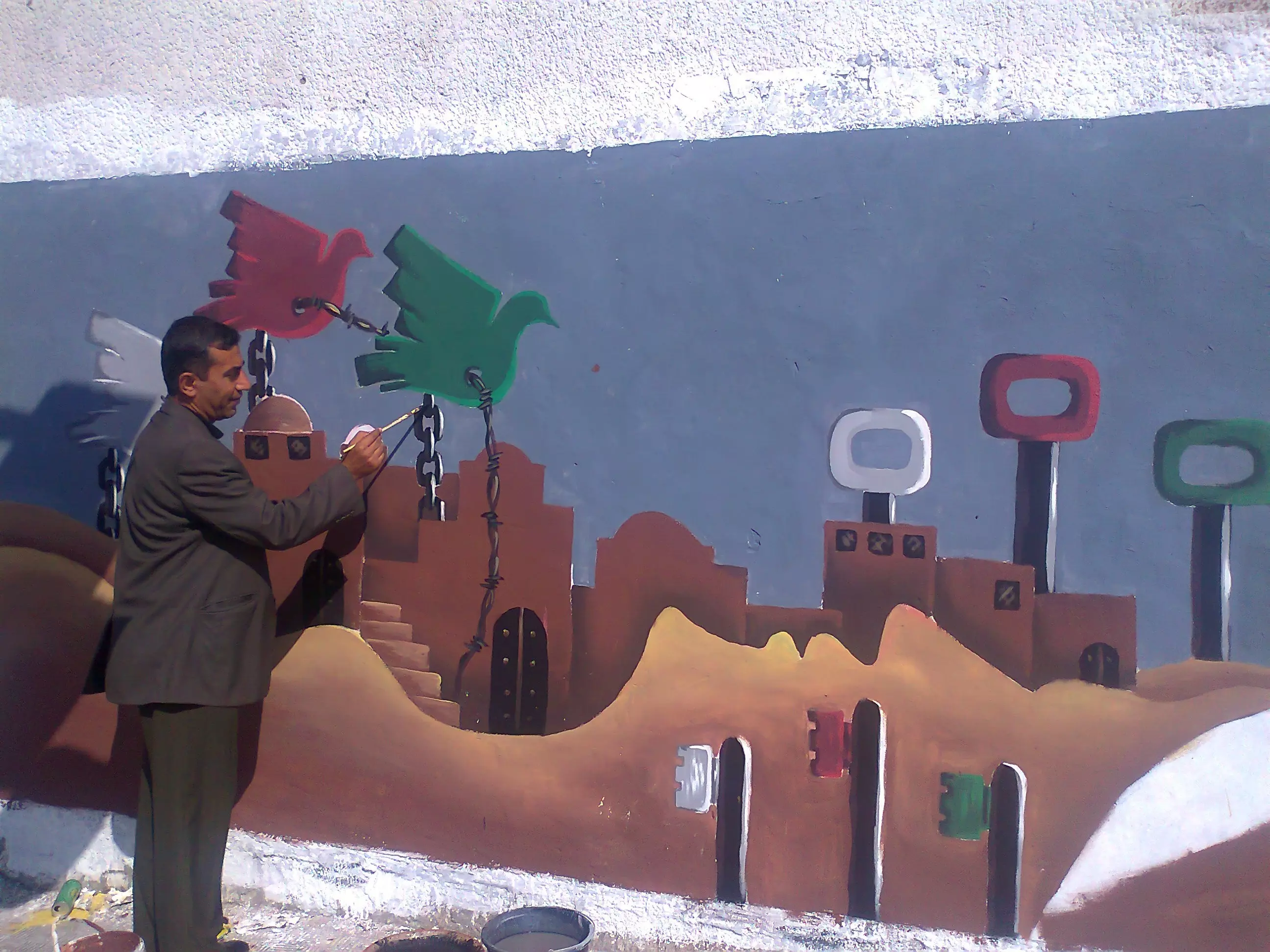
Posted by ابو محمد - العودة
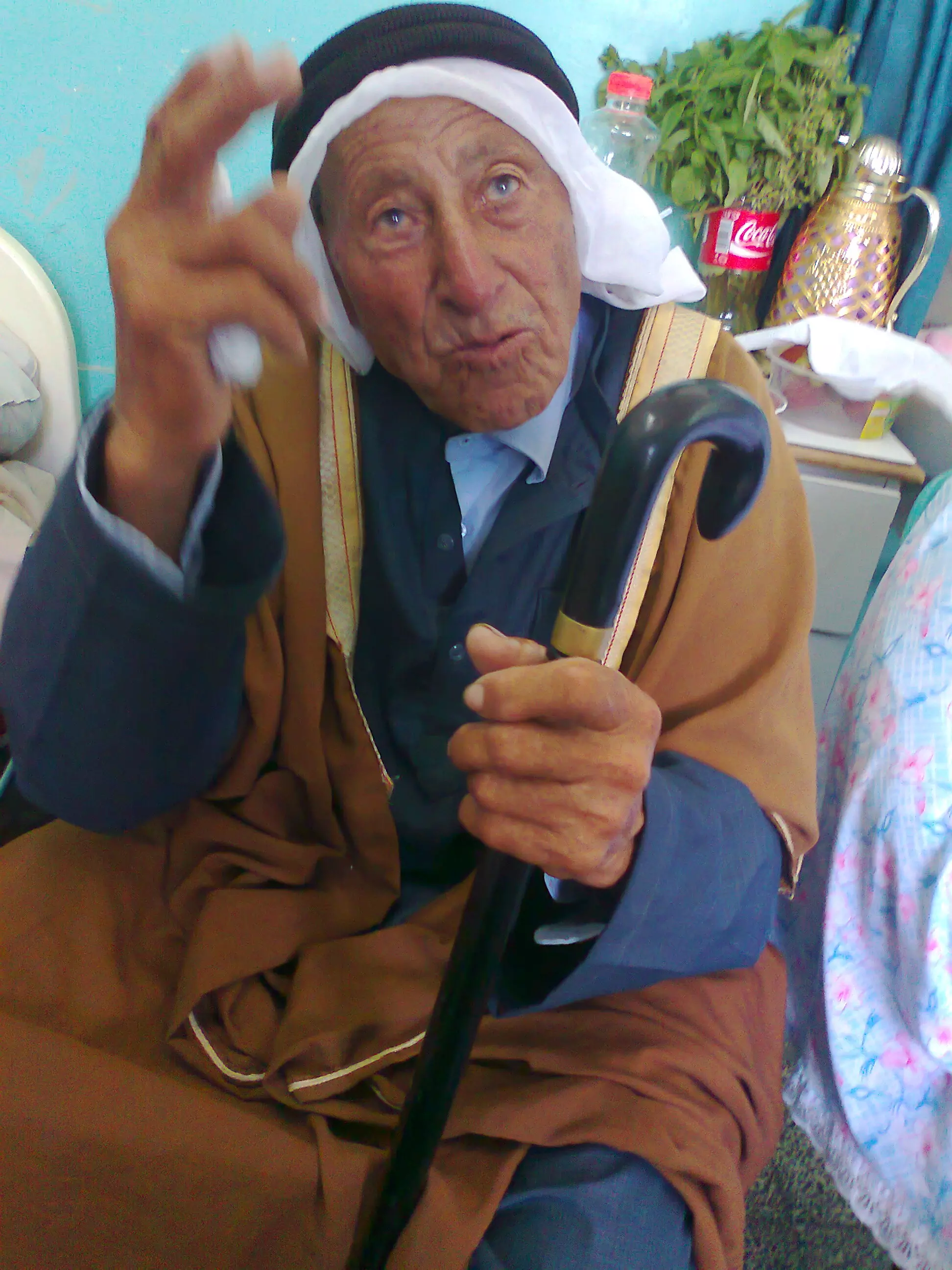
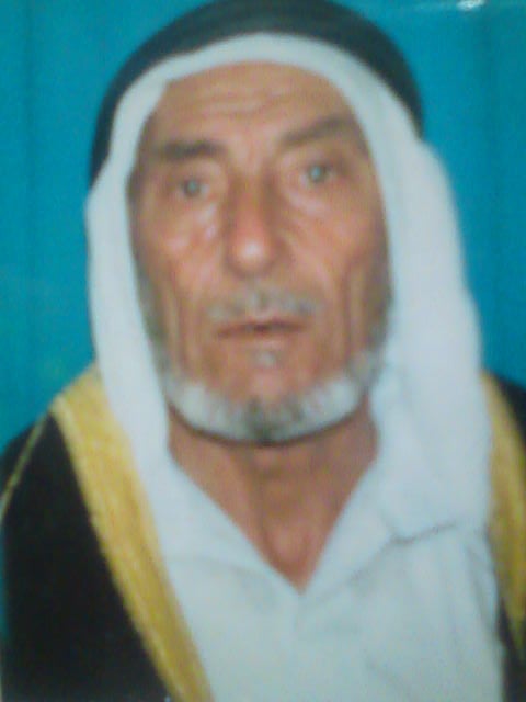
Posted by القاسم - الحاج المناضل المرحوم مختار ال قاسم وسالم / محمد يوسف عايش قاسم مواليد 1927م وتوفي 2006م
Posted by القاسم 7 - الحاج / يونس محمد عبد الرحمن منصور مواليد البطاني الشرقي
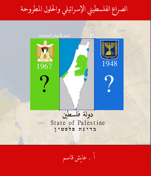
Posted by القاسم 5 - كتاب الصراع الفلسطيني الاسرائيلي
Posted by القاسم - Pre-Nakba Aerial view of the village / صورة من الجو للقرية اخذت قبل النكبة
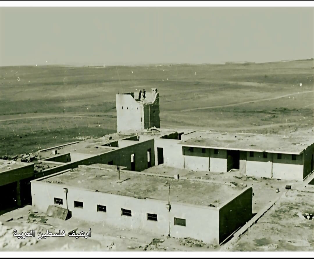
- مركز شرطة قرية البطاني الشرقي قضاء غزة بعد عامين من تهجير الأهالي، الصورة عام 1950..
Want to browse more? 80,000 pictures were grouped in these gallaries:
| Display Name | Clan/Hamolah | Country of Residence |
| Abu Ali Qasem | قاسم | - |
| Eyad Musallam | - | Riyadh, K.S.A |
| غازي | مصلح | غزة, فلسطين |
| أبو محمد | مصلح | غزة, فلسطين |
| ابو سهيل | خلف | اسطنبول, تركيا |
| ابوخالد ؛يونس؛ | منصور | الشارقه, الامارات |
| ابو عمر | منصور | جرش, الاردن |
| أبو أنس | حمدان | الوسطى |
| القاسم | - | فلسطين, م جباليا |
| f9fadi | odeh | baqaa camp, baqaa camp |
| يوسف مصلح | مصلح | Berlin |
| محمد ابراهيم | مصلح | عمان, الاردن |
| Abdul Raheem | Musleh | Abu Dhabi, UAE |
| Ali Musallam | Musallam | - |
| Mohammad Gazal | Gazal | Rhiyad, KSA |
 Fake Valor: Why Did Zionist Jews Hoist Nazis Flag on Their Ships in the 1930s?
What is new?
-
Facts About Oct. 7th Gaza Raid
-
Remined Us Please:: Who Did Rape Who? Palestinians Raped Israelis? Or, was the other way around?
-
When Prof. Edward Said was invited to debate Bibi Netanyahu in the 1980s, watch what happened!
-
Ezra Klein of the NY Times on the "Jewish Race".
-
Abusing Blood Libel!
-
Did Israeli Soldiers Activate The Hanniba Direective On Oct. 7th? You Be The Judge
-
Zionist FAQ: Isn't it true that Palestinians don't want peace? Palestinians never accepted the two-state solution
- Facts about Haavara (Transfer) Agreement between Ben-Gurion & Hitler
-
Haavara FAQs: Why Did Zionist Jews Hoist Nazis' Flags on Their Ships in the 1930s?
- Haavara FAQs: When Chaim Weizmann met FDR in mid-1943, why was he silent about rescuing European Jewry?
-
Dear ChatGPT: How did Palestinians resist Napoleon's invasion of their country in 1799?
-
Dear ChatGPT: Gaza had a vibrant Jewish community in the mid-17th century. What happened to them?
-
Dear ChatGPT: Why did the Jewish Agency suppress news of the Holocaust during WWII?
-
Video Playlist: Jews share their DNA tests to end the conflict for good.
-
A Tale of Two Conflicts: Examining the Definition of Genocide
-
Prof. Abraham Polak And The Suppressed History of the Khazars and European Jewry
-
How Ronald Reagan would have framed the genocide in Gaza if he were still alive?
-
Haavara FAQs: Let us do the math: how many German Jews did The Haavara Agreement save?
-
Zionist FAQs: The Hebron Massacre of 1929, "clearly proves" that Palestinians are antisemitic, how could you deny it?
-
Zionist FAQs: Why Anti-Zionist Is Not Antisemitism?
-
Zionist FAQs: Isn't it true that the KGB created Palestinian Nationalism in the early 1960s?
- Zionist FAQs: Muslims are killing Muslims all the time; why are Israeli Jews being singled out in the media?
- Zionist FAQs: How is Israel an apartheid state when 20% of its citizens are Arabs who enjoy full rights?
-
Haavara FAQs: Why Did Dorothy Thompson Flip From A Zionist Advocate to A Silenced Dissenter?
-
Haavara FAQs: Analysis of Herzl's Uganda Scheme and how it could have saved millions of Jews.
-
Haavara FAQs: Why did Hayim Greenberg describe American Jewry as "morally bankrupt" in early 1943?
-
Haavara FAQs: What if the Evian Conference was a resounding success? What would have been the impact of saving European Jewry on Zionism?
- Haavara FAQs: What if the six million were saved, how that would have impacted the Zionist project?
-
Haavara FAQs: How did Zionist leaders react when Europe's Jews lingered in the DP camps after WWII ended?
-
Why does the American Jewish community repeat lies that David Ben-Gurion had debunked before he died?
-
Who has the power to rename the Tatar/Khazar Gene Marker to Jewish IV?
-
Zionist FAQs: Why won't Egypt, Syria, and Jordan take their people back? Jews are indigenous to Palestine, and Arabs immigrated after Jews developed the country. Arabs should leave.
-
Haavara FAQs: Did Hitler and the Nazis conflate between Judaism and Zionist? If that wasn't case, then why?
-
Haavara FAQs: Winston Churchill and antisemitism, a collection of articles written Churchill.
-
Haavara FAQs: Broken by country, how many Jews survived vs. killed during the Holocaust?
-
Haavara FAQs: Why did European Jews vote with their feet and to immigrated to the Americas, not Palestine, after WWII?
-
Watch this American Jewish Girl describing Israeli Jews' cognitive dissonance like no other in under two minutes
-
Haavara FAQs: When the Nazis went out of their way to hide the Holocaust, Israeli Jews did the exact opposite by broadcasting their genocide of Gazans. But why?
-
Haavara FAQs: How Zionist Jews went out of their to show their appreciation to Nazism and Fascism?
- Haavara FAQs: Why Zionist leaders were against bombing the death camps & the Railroads leading to them?
-
Haavara FAQs: Hitler's message to the British and American people: If Jews are such noble citizens and you care about them, how come you're not letting them in? I will gladly ship them to you at my expense, even on luxury liners!
-
A shortlist of Zionist and Israeli false flag operations in the name Jews.
-
The Most Moral Army
- The Land of Kapos (Israel): Where the brave are boycotted and Kapos walk free.
- Why did early Zionists often named their communal enterprises "colonial"?
- Zionist Relations with Nazi Germany by Faris Glubb
-
Two NY Times advertisements by Zionists in the early 1943 that exposes Zionists' treason at the height of the calamity
- Facts Not Lies about the Palestinian-Israeli Conflict.
- Site's pictures have been categorized
- Campgain Against Lice
- A Survey of Palestine, the official source about Palestine before Nakba produced by the British Mandate; over 1200 pages.
- Satellite View & Google Earth: Over 6,000 placemarks identifying all destroyed towns, W. Bank & Gaza Strip Towns, & refugee camps.
- PalestineRemembered.com and its Nakba Oral History Project were featured on al-Jazeera Satellite TV.
- Nakba Oral History Video Podcast:
 Over 700 Oral History interviews (including 3,500+ hours of recording) can be viewed online.
 - Palestine Village Statistics Project
- Gaza Jail Break
- النسخة العربية للموقع الان متوفرة
- Videos: Documenting the destroyed villages in video: Tracing all that remains since Nakba.
- Videos: Responding to Zionist Propaganda
- Interview: The ethnic cleansing of Palestine: George Galloway interviews Israeli Historian Ilan Pappe.
- For Palestinians, memory matters. It provides a blueprint for their future By George Bisharat.
- Zionist FAQ now available in Hebrew שאלות שציונים שואלים, עכשיו בעברית
- Video: The Stephen Walt and John Mearsheimer report on the influence of the Israel Lobby on U.S. Foreign Policy
- The Palestinian-Israeli conflict for beginners
