| PalestineRemembered | About Us | Oral History | العربية | |
| Pictures | Zionist FAQs | Haavara | Maps | |
| Search |
| Camps |
| Districts |
| Acre |
| Baysan |
| Beersheba |
| Bethlehem |
| Gaza |
| Haifa |
| Hebron |
| Jaffa |
| Jericho |
| Jerusalem |
| Jinin |
| Nablus |
| Nazareth |
| Ramallah |
| al-Ramla |
| Safad |
| Tiberias |
| Tulkarm |
| Donate |
| Contact |
| Profile |
| Videos |
Welcome To Bayt Daras - بيت دراس (בית דראס)
|
District of Gaza
Ethnically cleansed days ago |
العربية Google Earth |
 |
Gallery (17) |
- Statistics & Facts
-
Before & After

- Satellite View
- Articles 5
- Pictures 17
- Aerial Views 3
- Oral History 3
- Members 49
- Families
- All That Remains
- Wikipedia
- Videos 2
- Guest Book 111
- Links 4
| Statistic & Fact | Value | ||||||||||||||
| Occupation Date | May 11, 1948 | ||||||||||||||
| Distance From District | 32 (km) North East of Gaza | ||||||||||||||
| Elevation | 50 (meters) | ||||||||||||||
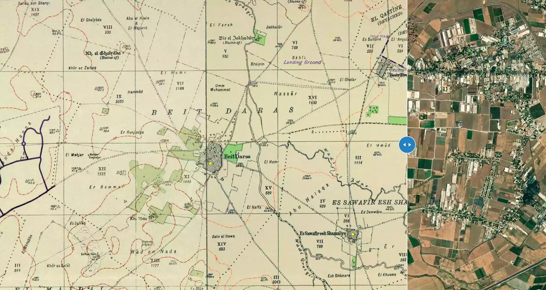
| Before & After Nakba, Click Map For Details |
|||||||||||||||
|
|||||||||||||||
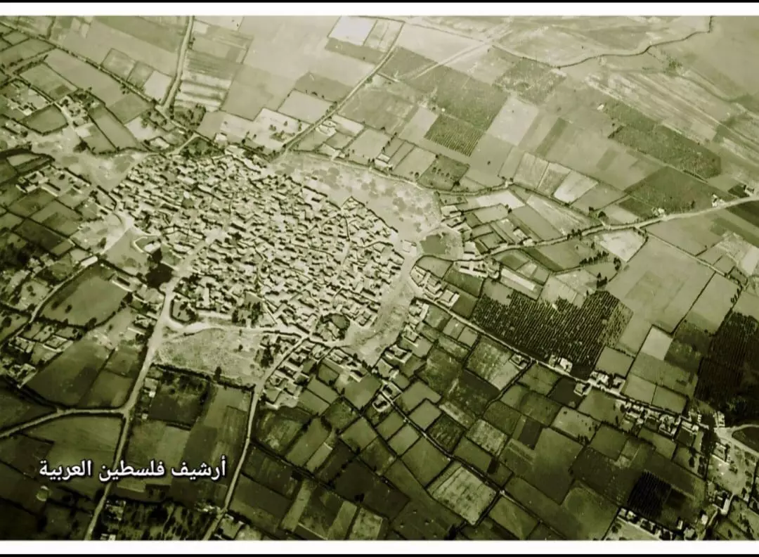
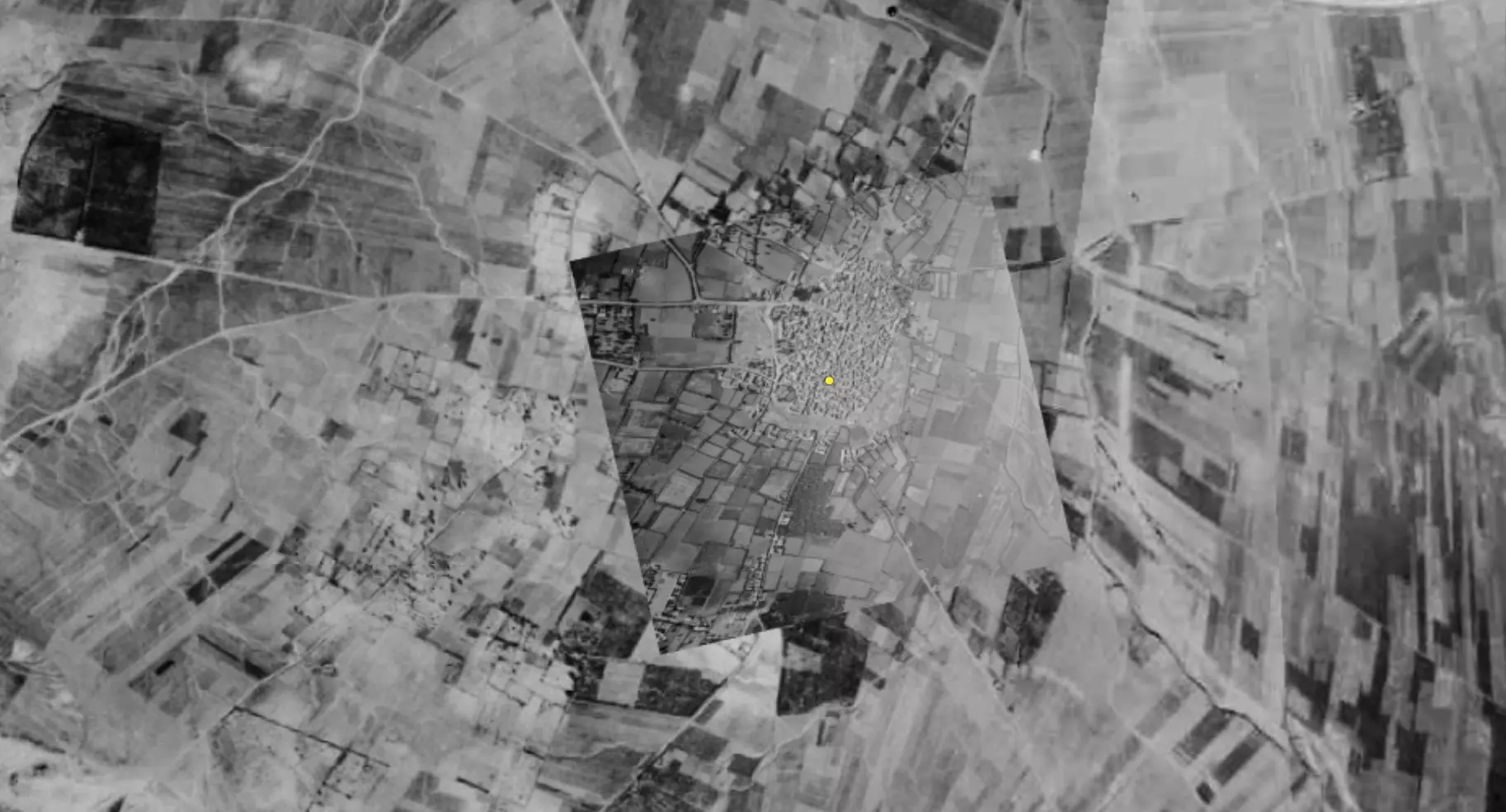
| Pre-Nakba Aerial View |
|||||||||||||||
|
|||||||||||||||
| Map Location | See location #11 on the map View from satellite |
||||||||||||||
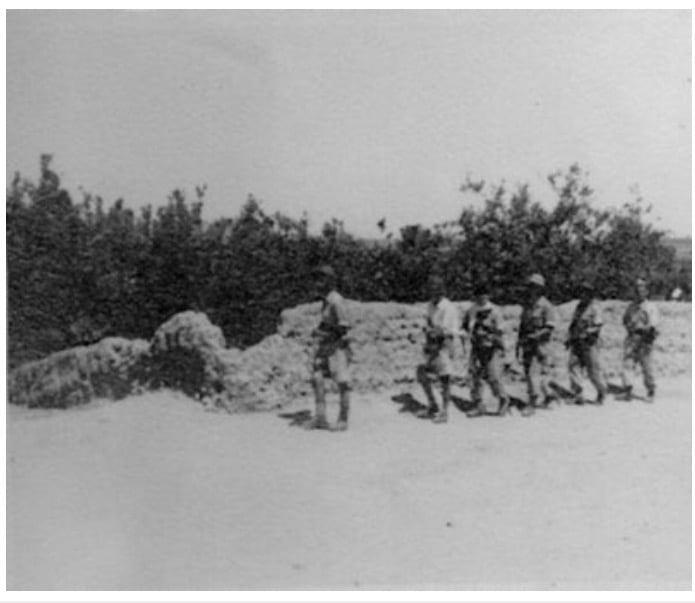
| Military Operation | Operation Barak (lightening) | ||||||||||||||
| Attacking Units | Giv'ati Brigade | ||||||||||||||
| Defenders | Sudanese Army soldiers. | ||||||||||||||
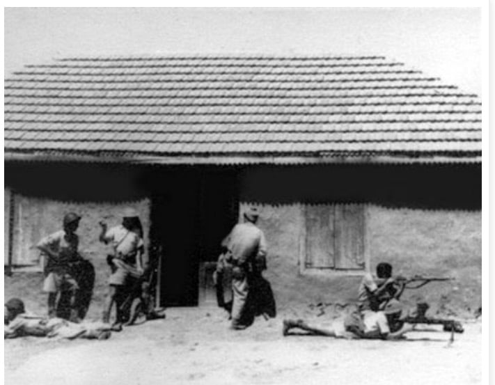
| Acts of Terror | Massacre occured by Zionist troops against the town's inhabitants. | ||||||||||||||
| Exodus Cause | Military assault by Zionist troops | ||||||||||||||
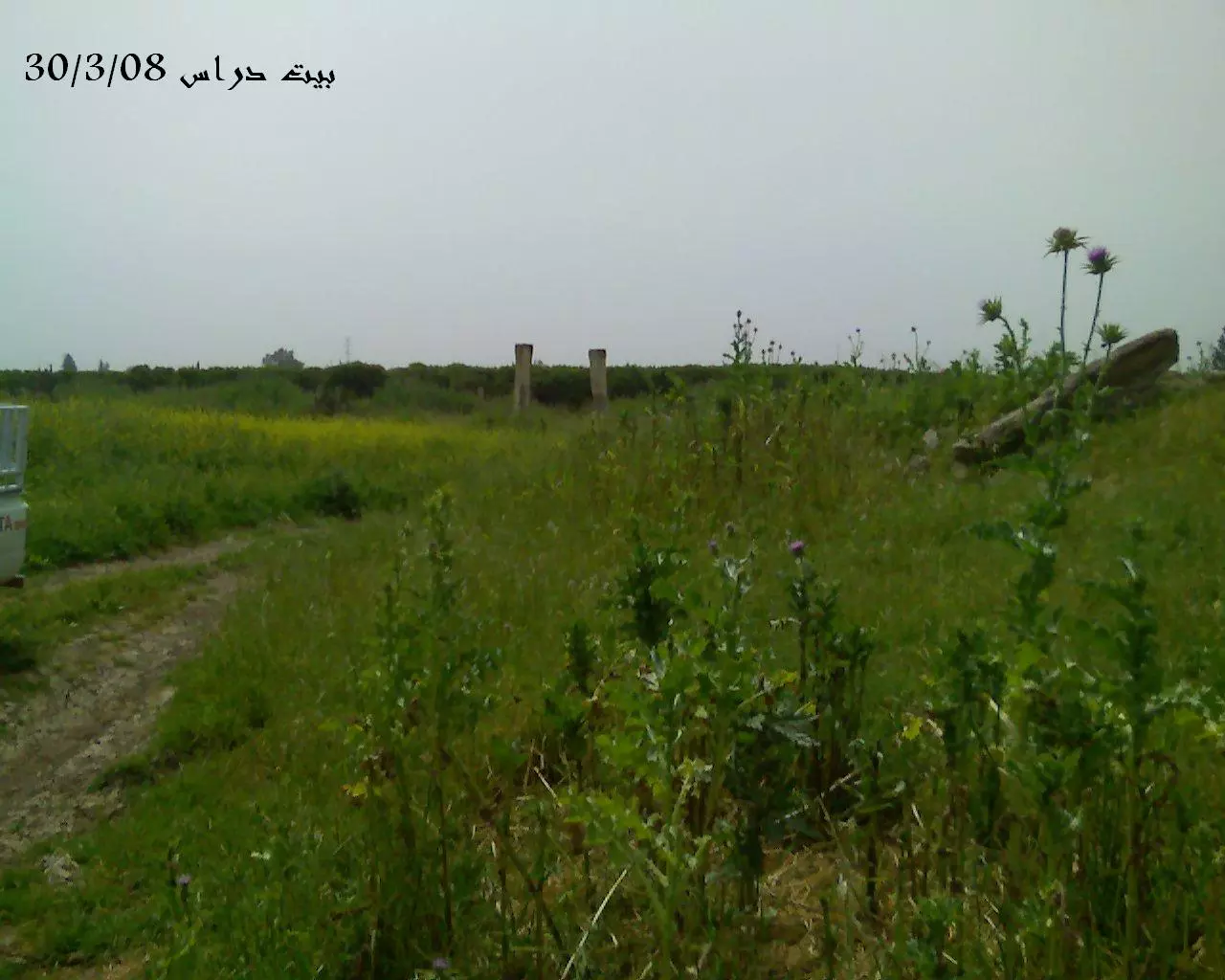
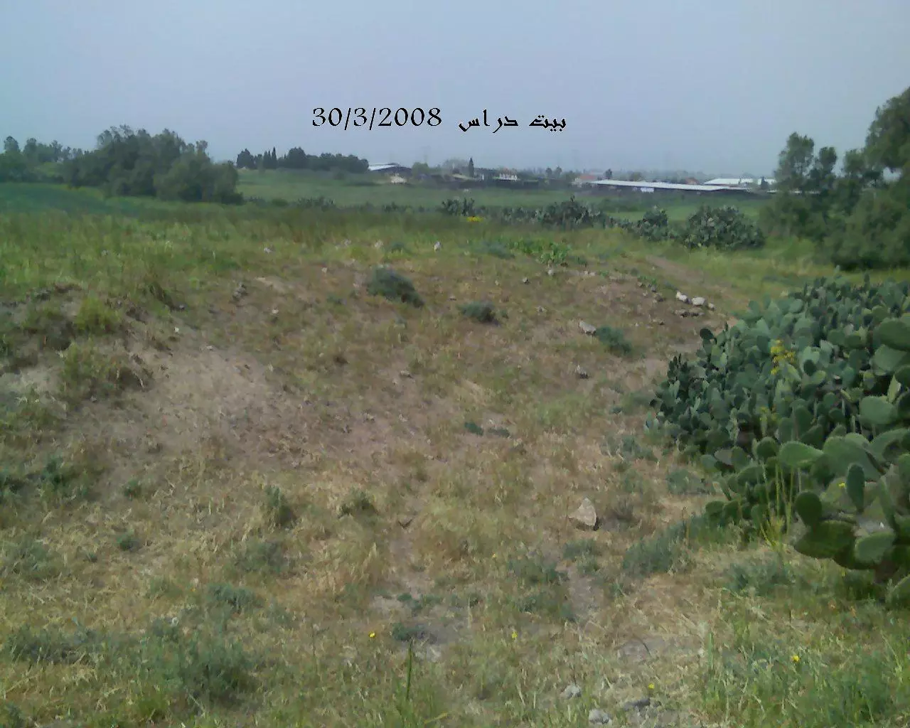
| Village Temains | The village was completely destroyed, and only house rubble left behind. | ||||||||||||||
| Ethnically Cleansing | Bayt Daras inhabitants were completely ethnically cleansed. | ||||||||||||||
| Pre-Nakba Land Ownership |
|
||||||||||||||
| Land Usage As of 1945 |
|
||||||||||||||
| Population |
|
||||||||||||||
| Number of Houses |
|
||||||||||||||
| Near By Towns |
|||||||||||||||
|
|||||||||||||||
| Schools | Bayt Daras had an elementary school which was founded in 1921, and in 1945 it had an enrollment of 234 students. | ||||||||||||||
| Places of Warship | Two mosques | ||||||||||||||
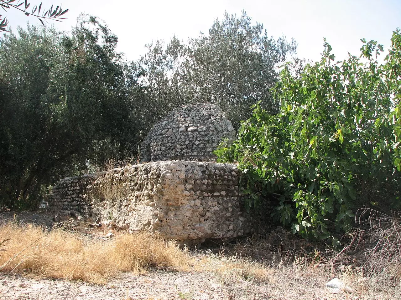
| Archeological Sites | The village contained stone foundations and vaulted rooms. | ||||||||||||||
| Exculsive Jewish Colonies Who Usurped Village Lands |
'Azriqam, Emunim, and Khirbat 'Awda | ||||||||||||||
| Featured Video | |||||||||||||||
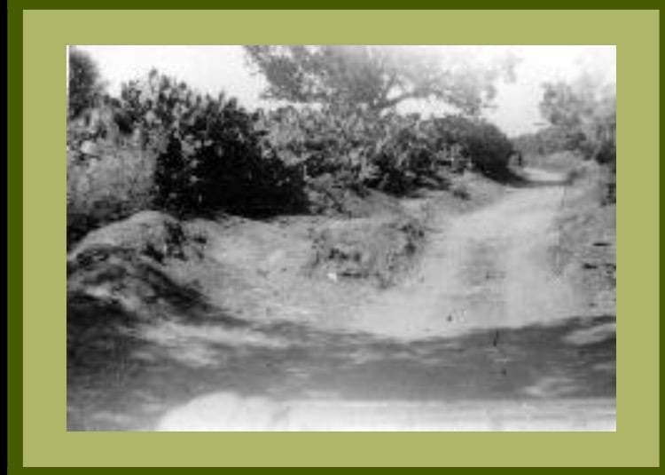
Village Before NakbaThe village was situated in a flat area that sloped upwards on the west and southwest to form a hill. Bayt Daras was linked by a network of dirt roads to neighboring villages, such as Isdud (on the coastal highway) and Julis, which helped to make it into a rural center. The Crusaders built a castle on the hill that overlooked the village. The Mamluks (1205–1517) made Bayt Daras one of the mail stations between Gaza and Damascus and built a khan, or caravansary, there. In 1596, Bayt Daras was a village in the nahiya of Gaza (liwa' of Gaza) with a population of 319. It paid taxes on a number of crops, including wheat and barley, as well as on other types of produce and property, such as goats, beehives, and vineyards.In the late nineteenth century, the village of Bayt Daras was surrounded by gardens and olive groves and was bordered to the north by a pond. Its houses were built of adobe brick. In modern times the village expanded southwestward along the road to Julis. It had two mosques, as well as an elementary school (established in 1921) that had 234 students enrolled in the mid-1940s. The evenness of the land and the availability of water rendered a large part of the land arable, and the people of this community worked mostly in rainfed agriculture, growing grain, fruit (especially citrus), and vegetables. In 1944/45 a total of 832 dunums was devoted to citrus and bananas and 14,436 dunums were allocated to cereals; 472 dunums were irrigated or used for orchards. The inhabitants also raised poultry and some worked in handicrafts and commerce. Bayt Daras had an archaeological site that contained stone foundations and vaulted rooms. Village Occupation and Ethnic CleaningBayt Daras was first attacked by Zionist forces in the early weeks of the war. The commander of Arab militia forces in the area described an assault consisting of indiscriminate mortar bombardment on 27–28 March 1948. Commander Tariq al-Ifriqi said that the attack left nine villagers dead, all noncombatants, and caused a fire in the village that burned crops and livestock. Earlier in the day, a skirmish had broken out between Arab militiamen and a Jewish convoy in the area. There was another brief battle around the village after a Jewish attack two days later, on 29 March.Bombarding the village with mortar fire before launching a ground assault, the Giv'ati Brigade occupied Bayt Daras on 10 May 1948, according to Israeli historian Benny Morris. The assault took place at the beginning of Operation Barak. Morris states that the inhabitants fled during the attack and that their houses were blown up in the context of 'clearing' the Giv'ati's southern front before 15 May, in accordance with Plan Dalet. Egyptian accounts state that the village was not occupied by Israeli forces until shortly after the first truce began on 11 June. Staff officer of the Sixth Battalion Gamal Abdel Naser (later president of Egypt) recalled that Israeli forces used the truce as 'an opportunity for consolidation' in this area, occupying Bayt Daras. Arab forces had intended to recapture Bayt Daras after the truce ended on 9 July, but failed due to 'a comic stroke of bad luck,' according to Abd al-Nasir. According to the plan, a Sudanese force was to occupy the village in a night attack, firing a green success signal to alert the Egyptian Seventh Battalion, which would move in to consolidate the victory. In case of failure, a red signal was to be fired and the Sudanese force was to withdraw to allow the artillery to go into action. Bayt Daras was indeed occupied by the Sudanese forces, but the soldier charged with the task made a mistake, firing the red instead of the green signal. Accordingly, the Egyptian artillery began bombarding the area, forcing the Sudanese from the positions they had taken in the village. Zionists Colonies on Village LandsThree settlements were established in 1950 on village lands: Azriqam, Emunim, and Giv'ati. Later in the 1950s a farm called Zemorot was built on Khirbat Awda, which was also on village land.Village TodayThe only remains of village buildings are the foundation of one house and some scattered rubble. The site is overgrown with wild vegetation interspersed by cactuses and eucalyptus trees. At least one of the old streets is clearly recognizable. The surrounding lands are cultivated by the settlements.SourceDr. Walid al-Khalidi, 1992: All That Remains. |
|||||||||||||||
| Related Maps | Town Lands' Demarcation Maps خرائط للقضاء توضح حدود القرى والاودية Town's map on MapQuest View from satellite Help us map this town at WikiMapia |
||||||||||||||
| Related Links | Wikipedia's Page Facebook Page Google Search Google For Images Google For Videos |
||||||||||||||
| More Information | في كتاب كي لا ننسى في كتاب بلادنا فلسطين في كتاب النكبة والفردوس المفقود المزيد من موقع هوية |
||||||||||||||
- مدخل بيت داراس

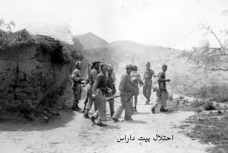
Posted by محمد ألأعسم 8 - احتلال بيت دراس

Posted by محمد ألأعسم 4 - بيت دراس

Posted by محمد ألأعسم 1 - بقايا مسجد بيت دراس

Posted by محمد ألأعسم 2 - بقايا مسجد بيت دراس
Posted by محمد ألأعسم 3 - مقبرة بيت دراس
Posted by محمد ألأعسم 8 - بيت داراس قبل النكبه
Posted by abu raya - العصابات الصهيونيه تهاجم القريه
Posted by abu raya - العصابات الصهيونبه في القريه
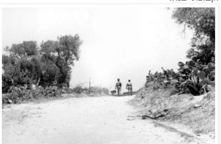
Posted by abu raya - العصابات الصهيونيه في بيت داراس
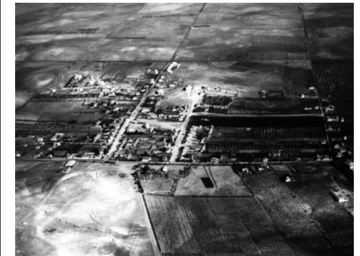
Posted by abu raya - صوره من الجو لقريه بيت داراس سنه 1918
Posted by abu raya - بيت دراس ١٩٤٨
Posted by أبو اليزن السعافين - إحتلال بيت دراس 1948
Posted by أبو اليزن السعافين - Pre-Nakba Aerial view of the village / صورة من الجو للقرية اخذت قبل النكبة
- صورة من الجو لبيت دراس قضاء غزة عام 1948..
- Let us see how the most "liberal and civilized" of world Jewry has obliterated our village, except for a few structures. How else will the Jews be great and safe again
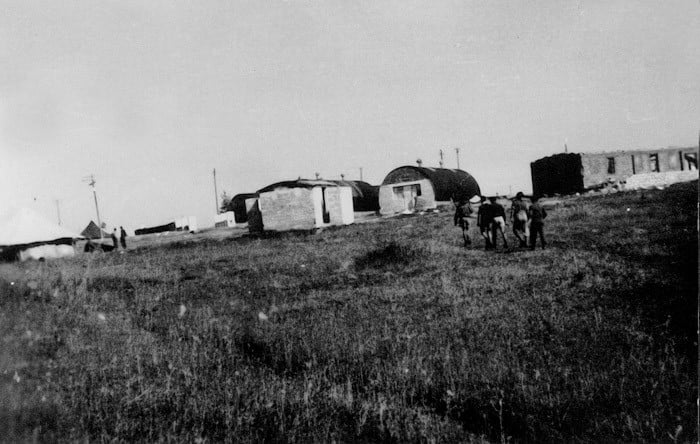
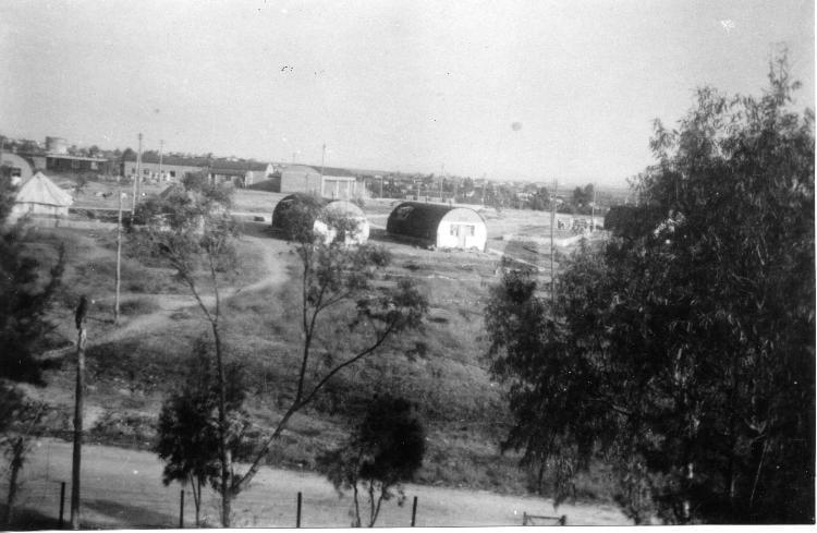
- Israeli army camp at Bayt Daras, 1948
Want to browse more? 80,000 pictures were grouped in these gallaries:
| Display Name | Clan/Hamolah | Country of Residence |
| Duh | - | Rafah |
| ريم أبوشمالة | أبوشمالة | - |
| د-محمد نصار | نصار | الرياض |
| ابو محمود | بارود | NRW, بيت داراس المانيا |
| Ahmad Salem Al yazouri | اليازوري | AbuDhabi |
| محمد عبد القادر إسماعيل عمار | عائلة عمار | - |
| ماجد | أبو شمّالة | دمشق مخيم اليرموك , سوريا |
| محمود تايه | تايه | غزة |
| محمد أبو شمالة | أبو شمالة | غزة |
| DESERT F O X | ابو شمالة | -, GAZA |
| نبيل موسى | موسى | غزة |
| حسن أبو شمالة | أبو شمالة | غزة |
| لينا بارود | بارود | عمان, الاردن |
| أبو صهيب | العسكري | غزة - معسكر جباليا |
| حسين الحاج خليل | أبوشمالة | الزرقاء, الأردن |
| مجد أبو شمالة | أبو شمالة | غزة |
| أبو أحمد | الخطيب | - |
| مفيد أحمد | أبوشمالة | - |
| مصعب تايه | تايه | qatar |
| ابومحمود | المقادمة | عمان, الاردن |
| الحوت | ابو شمالة | قطاع غزة, فلسطين |
| ابوعبدالله | - | جدة, السعودية |
| أبو المعتصم | عابد | غزة, فلسطيني |
| عمار | أبو شمالة | بيت دراس, النمسا |
| Yahya | المقادمة | - |
| ESSAM ABU SHAMMALAH | ABU SHAMMALAH | RIYADH, KSA |
| sakooob | - | - |
| محمد المقادمة | المقادمة | - |
| zombe | - | - |
| Mohamed Mutawe Hassan abu-shamala | - | Riyadh, Saudi Arabia |
| مفتول | - | gaza |
| ساره | - | amman |
| احمد ابوشماله | - | - |
| شاهين | أبو شمالة | - |
| مصعب | - | - |
| إسماعيل احمد فضل شاهين | ابو شماله | دبي, الامارات |
| kamham mohammad abushamaleh | - | - |
| FEW 2008 | SHAMMALA | GAZA, PALESTINE |
| مجاهد البدرساوي | أبو شمالة | غزة, فلسطين |
| عقيل | أبو شمالة | - |
| أبو عبادة المقدسي | - | - |
| أبوأحمد | الخطيب | خانيونس |
| ابو عمار | عائلة عمار | - |
| أبوصخر | المقادمة | al remal, فلسطين |
| faried aboushamalah | motawe aboushamalah | ontario, canada |
| khaled abu shamaleh | - | saudi arabia, 009662 |
| Hisham Ammar | - | Copenhagen, Denmark |
| عادل رشيد أبو انس | الأسعد | - |
| khalid younis | al mqadmeh | - |
- زيارة لقرية ابيت دراس المهجرة -- تصوير قيس فحماوي Duration: 13 min 45 sec
- سلسلة حكاية قرية من فلسطين| قرية بيت دراس (4) موسوعة القرى الفلسطينية Duration: 6 min 36 sec
 Fake Valor: Why Did Zionist Jews Hoist Nazis Flag on Their Ships in the 1930s?
What is new?
-
Facts About Oct. 7th Gaza Raid
-
Remined Us Please:: Who Did Rape Who? Palestinians Raped Israelis? Or, was the other way around?
-
When Prof. Edward Said was invited to debate Bibi Netanyahu in the 1980s, watch what happened!
-
Ezra Klein of the NY Times on the "Jewish Race".
-
Abusing Blood Libel!
-
Did Israeli Soldiers Activate The Hanniba Direective On Oct. 7th? You Be The Judge
-
Zionist FAQ: Isn't it true that Palestinians don't want peace? Palestinians never accepted the two-state solution
- Facts about Haavara (Transfer) Agreement between Ben-Gurion & Hitler
-
Haavara FAQs: Why Did Zionist Jews Hoist Nazis' Flags on Their Ships in the 1930s?
- Haavara FAQs: When Chaim Weizmann met FDR in mid-1943, why was he silent about rescuing European Jewry?
-
Dear ChatGPT: How did Palestinians resist Napoleon's invasion of their country in 1799?
-
Dear ChatGPT: Gaza had a vibrant Jewish community in the mid-17th century. What happened to them?
-
Dear ChatGPT: Why did the Jewish Agency suppress news of the Holocaust during WWII?
-
Video Playlist: Jews share their DNA tests to end the conflict for good.
-
A Tale of Two Conflicts: Examining the Definition of Genocide
-
Prof. Abraham Polak And The Suppressed History of the Khazars and European Jewry
-
How Ronald Reagan would have framed the genocide in Gaza if he were still alive?
-
Haavara FAQs: Let us do the math: how many German Jews did The Haavara Agreement save?
-
Zionist FAQs: The Hebron Massacre of 1929, "clearly proves" that Palestinians are antisemitic, how could you deny it?
-
Zionist FAQs: Why Anti-Zionist Is Not Antisemitism?
-
Zionist FAQs: Isn't it true that the KGB created Palestinian Nationalism in the early 1960s?
- Zionist FAQs: Muslims are killing Muslims all the time; why are Israeli Jews being singled out in the media?
- Zionist FAQs: How is Israel an apartheid state when 20% of its citizens are Arabs who enjoy full rights?
-
Haavara FAQs: Why Did Dorothy Thompson Flip From A Zionist Advocate to A Silenced Dissenter?
-
Haavara FAQs: Analysis of Herzl's Uganda Scheme and how it could have saved millions of Jews.
-
Haavara FAQs: Why did Hayim Greenberg describe American Jewry as "morally bankrupt" in early 1943?
-
Haavara FAQs: What if the Evian Conference was a resounding success? What would have been the impact of saving European Jewry on Zionism?
- Haavara FAQs: What if the six million were saved, how that would have impacted the Zionist project?
-
Haavara FAQs: How did Zionist leaders react when Europe's Jews lingered in the DP camps after WWII ended?
-
Why does the American Jewish community repeat lies that David Ben-Gurion had debunked before he died?
-
Who has the power to rename the Tatar/Khazar Gene Marker to Jewish IV?
-
Zionist FAQs: Why won't Egypt, Syria, and Jordan take their people back? Jews are indigenous to Palestine, and Arabs immigrated after Jews developed the country. Arabs should leave.
-
Haavara FAQs: Did Hitler and the Nazis conflate between Judaism and Zionist? If that wasn't case, then why?
-
Haavara FAQs: Winston Churchill and antisemitism, a collection of articles written Churchill.
-
Haavara FAQs: Broken by country, how many Jews survived vs. killed during the Holocaust?
-
Haavara FAQs: Why did European Jews vote with their feet and to immigrated to the Americas, not Palestine, after WWII?
-
Watch this American Jewish Girl describing Israeli Jews' cognitive dissonance like no other in under two minutes
-
Haavara FAQs: When the Nazis went out of their way to hide the Holocaust, Israeli Jews did the exact opposite by broadcasting their genocide of Gazans. But why?
-
Haavara FAQs: How Zionist Jews went out of their to show their appreciation to Nazism and Fascism?
- Haavara FAQs: Why Zionist leaders were against bombing the death camps & the Railroads leading to them?
-
Haavara FAQs: Hitler's message to the British and American people: If Jews are such noble citizens and you care about them, how come you're not letting them in? I will gladly ship them to you at my expense, even on luxury liners!
-
A shortlist of Zionist and Israeli false flag operations in the name Jews.
-
The Most Moral Army
- The Land of Kapos (Israel): Where the brave are boycotted and Kapos walk free.
- Why did early Zionists often named their communal enterprises "colonial"?
- Zionist Relations with Nazi Germany by Faris Glubb
-
Two NY Times advertisements by Zionists in the early 1943 that exposes Zionists' treason at the height of the calamity
- Facts Not Lies about the Palestinian-Israeli Conflict.
- Site's pictures have been categorized
- Campgain Against Lice
- A Survey of Palestine, the official source about Palestine before Nakba produced by the British Mandate; over 1200 pages.
- Satellite View & Google Earth: Over 6,000 placemarks identifying all destroyed towns, W. Bank & Gaza Strip Towns, & refugee camps.
- PalestineRemembered.com and its Nakba Oral History Project were featured on al-Jazeera Satellite TV.
- Nakba Oral History Video Podcast:
 Over 700 Oral History interviews (including 3,500+ hours of recording) can be viewed online.
 - Palestine Village Statistics Project
- Gaza Jail Break
- النسخة العربية للموقع الان متوفرة
- Videos: Documenting the destroyed villages in video: Tracing all that remains since Nakba.
- Videos: Responding to Zionist Propaganda
- Interview: The ethnic cleansing of Palestine: George Galloway interviews Israeli Historian Ilan Pappe.
- For Palestinians, memory matters. It provides a blueprint for their future By George Bisharat.
- Zionist FAQ now available in Hebrew שאלות שציונים שואלים, עכשיו בעברית
- Video: The Stephen Walt and John Mearsheimer report on the influence of the Israel Lobby on U.S. Foreign Policy
- The Palestinian-Israeli conflict for beginners
