| PalestineRemembered | About Us | Oral History | العربية | |
| Pictures | Zionist FAQs | Haavara | Maps | |
| Search |
| Camps |
| Districts |
| Acre |
| Baysan |
| Beersheba |
| Bethlehem |
| Gaza |
| Haifa |
| Hebron |
| Jaffa |
| Jericho |
| Jerusalem |
| Jinin |
| Nablus |
| Nazareth |
| Ramallah |
| al-Ramla |
| Safad |
| Tiberias |
| Tulkarm |
| Donate |
| Contact |
| Profile |
| Videos |
Welcome To al-Jiyya - الجية (אל-ג'יה)
|
District of Gaza
Ethnically cleansed days ago |
العربية Google Earth |
 |
Gallery (2) |
- Statistics & Facts
-
Before & After

- Satellite View
- Articles 4
- Pictures 2
- Aerial Views 1
- Members 19
- Families
- All That Remains
- Wikipedia
- Videos
- Guest Book 17
- Links 2
| Statistic & Fact | Value | ||||||||||||||
| Occupation Date | November 4, 1948 | ||||||||||||||
| Distance From District | 19 (km) North East of Gaza | ||||||||||||||
| Elevation | 25 (meters) | ||||||||||||||
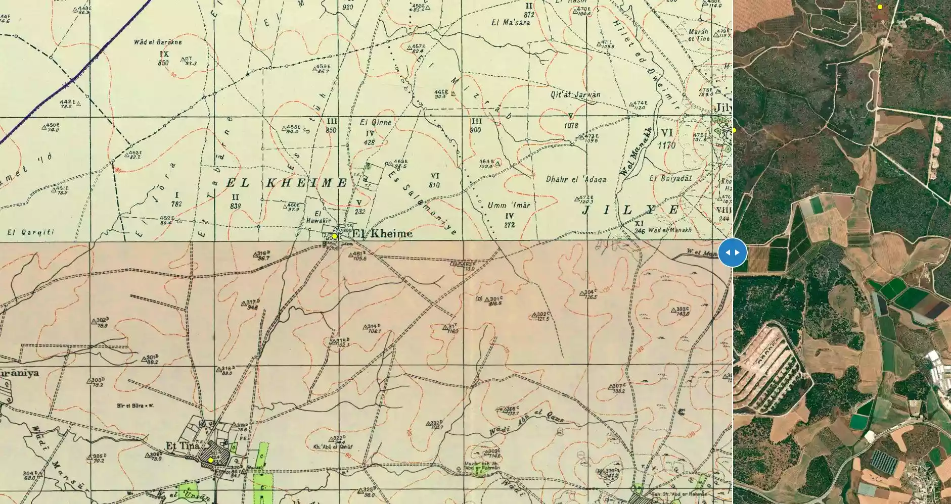
| Before & After Nakba, Click Map For Details |
|||||||||||||||
|
|||||||||||||||
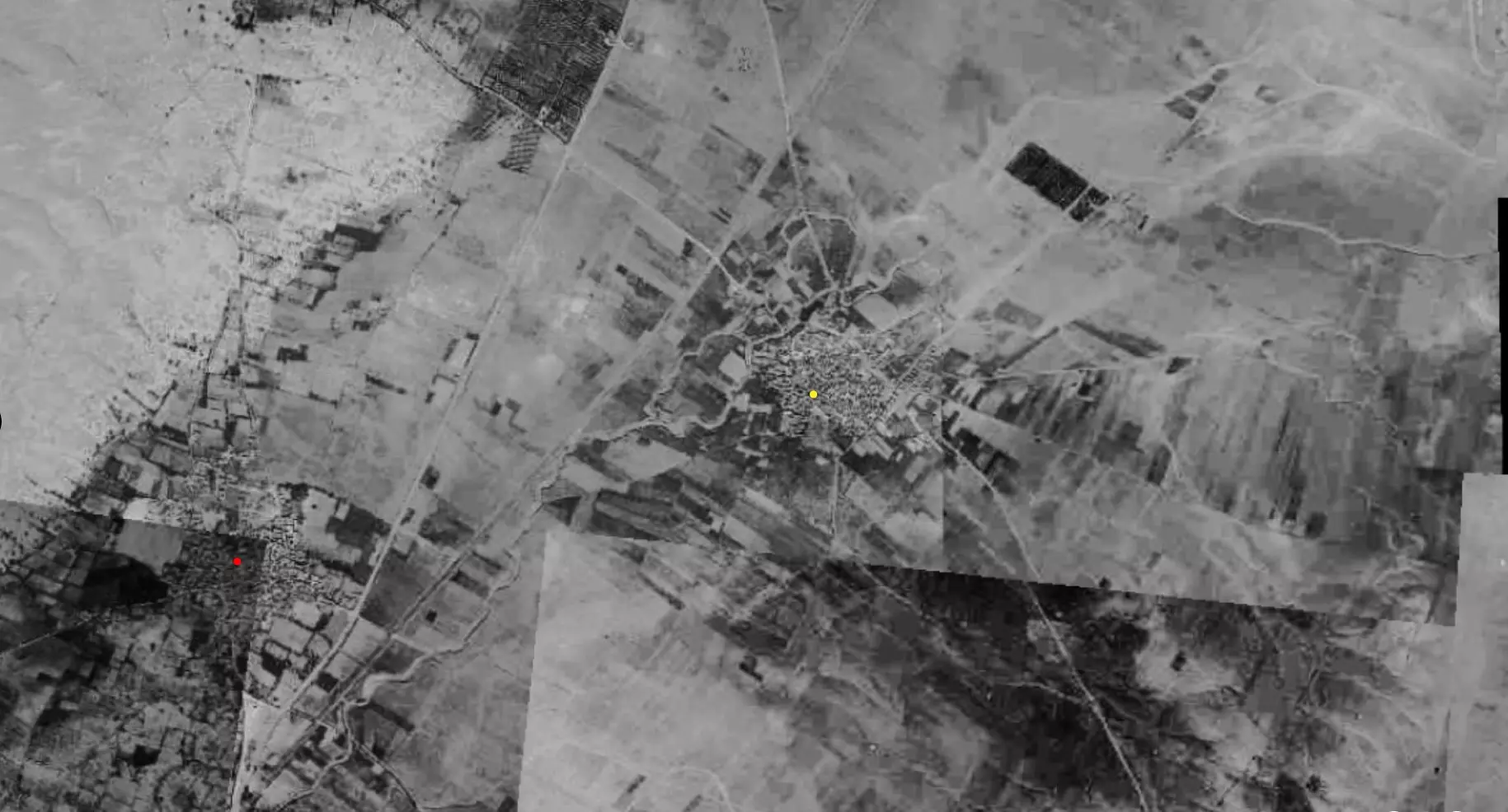
| Pre-Nakba Aerial View |
|||||||||||||||
|
|||||||||||||||
| Map Location | See location #29 on the map View from satellite |
||||||||||||||
| Military Operation | Operation Yo'av | ||||||||||||||
| Attacking Units | Possibly Giva'ti Brigade | ||||||||||||||
| Defenders | Egyptian Army | ||||||||||||||
| Exodus Cause | Military assault by Zionist troops | ||||||||||||||
| Village Temains | The village was completely obliterated. | ||||||||||||||
| Ethnically Cleansing | al-Jiyya inhabitants were completely ethnically cleansed. | ||||||||||||||
| Pre-Nakba Land Ownership |
**Town Lands' Demarcation Maps |
||||||||||||||
| Land Usage As of 1945 |
|
||||||||||||||
| Population |
|
||||||||||||||
| Number of Houses |
|
||||||||||||||
| Near By Towns |
|||||||||||||||
|
|||||||||||||||
| Town's Name Through History | The Crusades referred to al-Jiyya by Algie. | ||||||||||||||
| Schools | al-Jiyya had no schools, however, its students attended school in the nearby village of Barbara. | ||||||||||||||
| Places of Warship | One mosque | ||||||||||||||
| Archeological Sites | al-Jiyya contained a stone column and the remains of a Roman mill. | ||||||||||||||
| Exculsive Jewish Colonies Who Usurped Village Lands |
Moshav Ge'a and Beyt Shiqma | ||||||||||||||
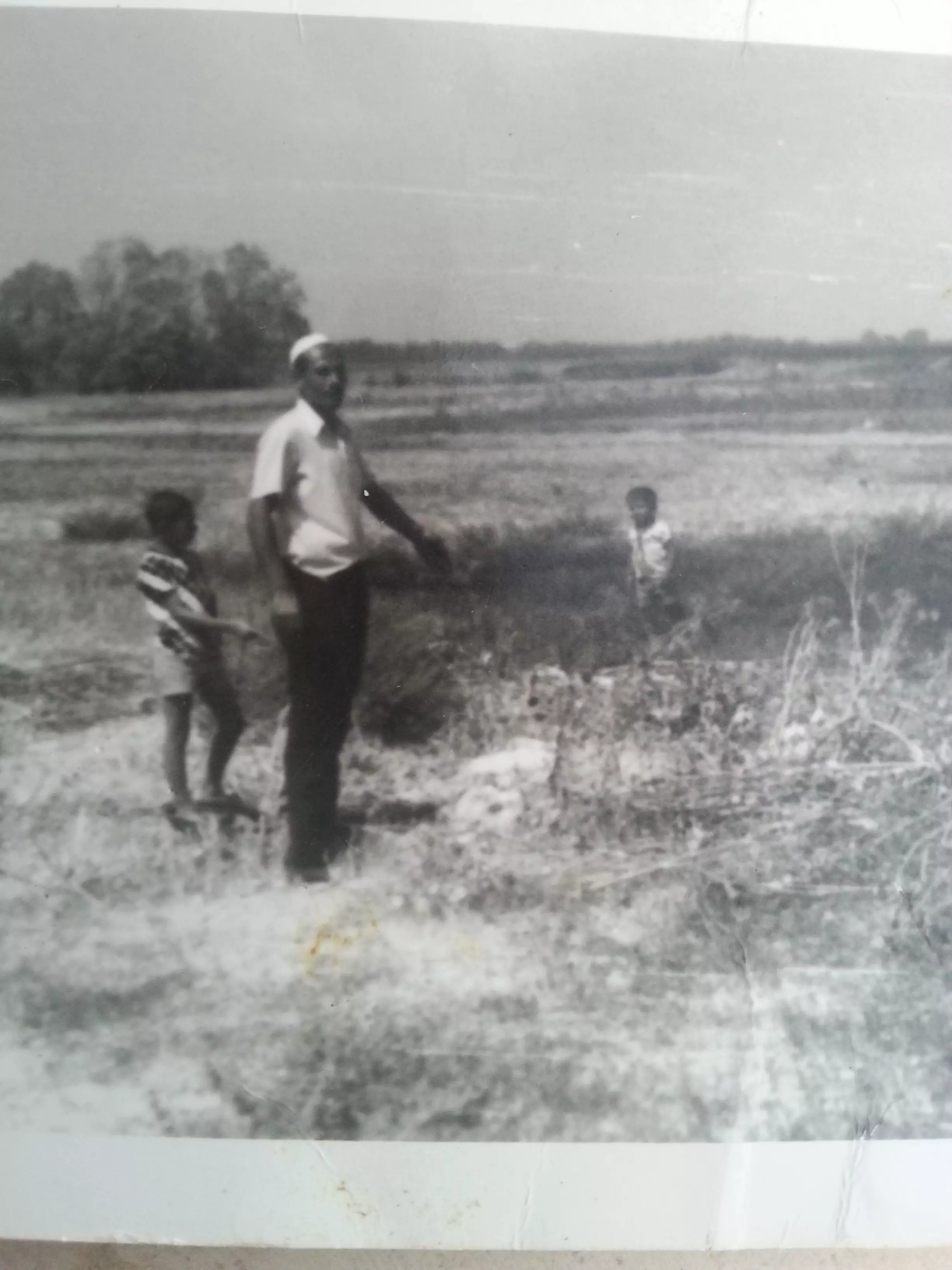
Village Before NakbaThe village was situated on a sandy spot, surrounded by hills, on the southern coastal plain. Several wadis descended around it and periodically subjected it to flooding. This perhaps explains its name, which means 'water collector' in Arabic, as well as its circular layout. The village has been identified with a town referred to in Crusader records as Algie. The coastal highway and railway line ran close to the village on its western side. The inhabitants reported that their village had been ruined at one point and then rebuilt by Muhammad Abu Nabbut, the governor of Jaffa and Gaza between 1807 and 1818.Al-Jiyya's population was Muslim and the village had its own mosque. Children attended school in the neighboring village of Barbara. The villagers installed a pump on one of the wells in the area to draw water for domestic use. The community worked primarily in agriculture, planting various types of grain, especially corn. In 1944/45 a total of 189 dunums was devoted to citrus and bananas and 8,004 dunums were allocated to cereals; 26 dunums were irrigated or used for orchards. Al-Jiyya also was known for its cheese and other dairy products which were sold in Gaza and the city of al-Majdal. Among the archaeological remains found in al-Jiyya were a stone column and the remains of a Roman mill. Village Occupation and Ethnic CleaningAl-Jiyya fell into Israeli hands at the same time as the city of al-Majdal, on 4–5 November 1948. This occurred at the end of Operation Yoav , one of the last major offensives of the war. Like most of the population of the area, the villagers of al-Jiyya probably fled or were expelled to the already over-populated Gaza Strip.Zionists Colonies on Village LandsMoshav Ge'a and Beyt Shiqma were established on village lands in 1949 and 1950, respectively.Village TodayAll traces of the village have been completely obliterated. Some sycamore trees grow on the site. Cantaloupes have been planted by the settlement of Beyt Shiqma on the surrounding lands.SourceDr. Walid al-Khalidi, 1992: All That Remains. |
|||||||||||||||
| Related Maps | Town Lands' Demarcation Maps خرائط للقضاء توضح حدود القرى والاودية Town's map on MapQuest View from satellite Help us map this town at WikiMapia |
||||||||||||||
| Related Links | Wikipedia's Page Google Search Google For Images Google For Videos |
||||||||||||||
| More Information | في كتاب كي لا ننسى في كتاب بلادنا فلسطين المزيد من موقع هوية |
||||||||||||||
Want to browse more? 80,000 pictures were grouped in these gallaries:
| Display Name | Clan/Hamolah | Country of Residence |
| أبو فجر | شعبان | غزة, فلسطين -الجية |
| Mahmoud Abed | Abed | Canada |
| لورد فلسطين | صيام | غزة, الجية |
| ibrahim shaban | عوض | north gaza, north gaza |
| ابوعبدالله | عوض | الوسطي, ديرالبلح |
| Dr-7mo_Od | ابوقاعود | doha, qatar |
| ابو جميل | سليمان | حائل, السعودية |
| حسام ابو شنب | ابو شنب | غزة |
| صلاح درويش | درويش | - |
| أبو أسامة | درويش | - |
| تهاني | العبد عوض | عمان, الأردن |
| دموع الحنان | الشنطي | غزه, غزه |
| Dr_7mood | - | Doha, Qatar |
| al-shanti | - | - |
| محمد صباح | صباح | Gaza |
| ابو عبدالله | ابو عواد | - |
| إسماعيل صيام | صيام | - |
| الصقر | - | - |
| jehad abu shanab | ابو شنب | doha |
 Fake Valor: Why Did Zionist Jews Hoist Nazis Flag on Their Ships in the 1930s?
What is new?
-
Facts About Oct. 7th Gaza Raid
-
Remined Us Please:: Who Did Rape Who? Palestinians Raped Israelis? Or, was the other way around?
-
When Prof. Edward Said was invited to debate Bibi Netanyahu in the 1980s, watch what happened!
-
Ezra Klein of the NY Times on the "Jewish Race".
-
Abusing Blood Libel!
-
Did Israeli Soldiers Activate The Hanniba Direective On Oct. 7th? You Be The Judge
-
Zionist FAQ: Isn't it true that Palestinians don't want peace? Palestinians never accepted the two-state solution
- Facts about Haavara (Transfer) Agreement between Ben-Gurion & Hitler
-
Haavara FAQs: Why Did Zionist Jews Hoist Nazis' Flags on Their Ships in the 1930s?
- Haavara FAQs: When Chaim Weizmann met FDR in mid-1943, why was he silent about rescuing European Jewry?
-
Dear ChatGPT: How did Palestinians resist Napoleon's invasion of their country in 1799?
-
Dear ChatGPT: Gaza had a vibrant Jewish community in the mid-17th century. What happened to them?
-
Dear ChatGPT: Why did the Jewish Agency suppress news of the Holocaust during WWII?
-
Video Playlist: Jews share their DNA tests to end the conflict for good.
-
A Tale of Two Conflicts: Examining the Definition of Genocide
-
Prof. Abraham Polak And The Suppressed History of the Khazars and European Jewry
-
How Ronald Reagan would have framed the genocide in Gaza if he were still alive?
-
Haavara FAQs: Let us do the math: how many German Jews did The Haavara Agreement save?
-
Zionist FAQs: The Hebron Massacre of 1929, "clearly proves" that Palestinians are antisemitic, how could you deny it?
-
Zionist FAQs: Why Anti-Zionist Is Not Antisemitism?
-
Zionist FAQs: Isn't it true that the KGB created Palestinian Nationalism in the early 1960s?
- Zionist FAQs: Muslims are killing Muslims all the time; why are Israeli Jews being singled out in the media?
- Zionist FAQs: How is Israel an apartheid state when 20% of its citizens are Arabs who enjoy full rights?
-
Haavara FAQs: Why Did Dorothy Thompson Flip From A Zionist Advocate to A Silenced Dissenter?
-
Haavara FAQs: Analysis of Herzl's Uganda Scheme and how it could have saved millions of Jews.
-
Haavara FAQs: Why did Hayim Greenberg describe American Jewry as "morally bankrupt" in early 1943?
-
Haavara FAQs: What if the Evian Conference was a resounding success? What would have been the impact of saving European Jewry on Zionism?
- Haavara FAQs: What if the six million were saved, how that would have impacted the Zionist project?
-
Haavara FAQs: How did Zionist leaders react when Europe's Jews lingered in the DP camps after WWII ended?
-
Why does the American Jewish community repeat lies that David Ben-Gurion had debunked before he died?
-
Who has the power to rename the Tatar/Khazar Gene Marker to Jewish IV?
-
Zionist FAQs: Why won't Egypt, Syria, and Jordan take their people back? Jews are indigenous to Palestine, and Arabs immigrated after Jews developed the country. Arabs should leave.
-
Haavara FAQs: Did Hitler and the Nazis conflate between Judaism and Zionist? If that wasn't case, then why?
-
Haavara FAQs: Winston Churchill and antisemitism, a collection of articles written Churchill.
-
Haavara FAQs: Broken by country, how many Jews survived vs. killed during the Holocaust?
-
Haavara FAQs: Why did European Jews vote with their feet and to immigrated to the Americas, not Palestine, after WWII?
-
Watch this American Jewish Girl describing Israeli Jews' cognitive dissonance like no other in under two minutes
-
Haavara FAQs: When the Nazis went out of their way to hide the Holocaust, Israeli Jews did the exact opposite by broadcasting their genocide of Gazans. But why?
-
Haavara FAQs: How Zionist Jews went out of their to show their appreciation to Nazism and Fascism?
- Haavara FAQs: Why Zionist leaders were against bombing the death camps & the Railroads leading to them?
-
Haavara FAQs: Hitler's message to the British and American people: If Jews are such noble citizens and you care about them, how come you're not letting them in? I will gladly ship them to you at my expense, even on luxury liners!
-
A shortlist of Zionist and Israeli false flag operations in the name Jews.
-
The Most Moral Army
- The Land of Kapos (Israel): Where the brave are boycotted and Kapos walk free.
- Why did early Zionists often named their communal enterprises "colonial"?
- Zionist Relations with Nazi Germany by Faris Glubb
-
Two NY Times advertisements by Zionists in the early 1943 that exposes Zionists' treason at the height of the calamity
- Facts Not Lies about the Palestinian-Israeli Conflict.
- Site's pictures have been categorized
- Campgain Against Lice
- A Survey of Palestine, the official source about Palestine before Nakba produced by the British Mandate; over 1200 pages.
- Satellite View & Google Earth: Over 6,000 placemarks identifying all destroyed towns, W. Bank & Gaza Strip Towns, & refugee camps.
- PalestineRemembered.com and its Nakba Oral History Project were featured on al-Jazeera Satellite TV.
- Nakba Oral History Video Podcast:
 Over 700 Oral History interviews (including 3,500+ hours of recording) can be viewed online.
 - Palestine Village Statistics Project
- Gaza Jail Break
- النسخة العربية للموقع الان متوفرة
- Videos: Documenting the destroyed villages in video: Tracing all that remains since Nakba.
- Videos: Responding to Zionist Propaganda
- Interview: The ethnic cleansing of Palestine: George Galloway interviews Israeli Historian Ilan Pappe.
- For Palestinians, memory matters. It provides a blueprint for their future By George Bisharat.
- Zionist FAQ now available in Hebrew שאלות שציונים שואלים, עכשיו בעברית
- Video: The Stephen Walt and John Mearsheimer report on the influence of the Israel Lobby on U.S. Foreign Policy
- The Palestinian-Israeli conflict for beginners
