| PalestineRemembered | About Us | Oral History | العربية | |
| Pictures | Zionist FAQs | Haavara | Maps | |
| Search |
| Camps |
| Districts |
| Acre |
| Baysan |
| Beersheba |
| Bethlehem |
| Gaza |
| Haifa |
| Hebron |
| Jaffa |
| Jericho |
| Jerusalem |
| Jinin |
| Nablus |
| Nazareth |
| Ramallah |
| al-Ramla |
| Safad |
| Tiberias |
| Tulkarm |
| Donate |
| Contact |
| Profile |
| Videos |
Welcome To al-Jalama - الجلمة (ח'ירבת אל-ג'למה)
|
District of Tulkarm
Ethnically cleansed days ago |
العربية Google Earth |
 |
Gallery (4) |
- Statistics & Facts
-
Before & After

- Satellite View
- Articles 1
- Pictures 4
- Members 1
- All That Remains
- Wikipedia
- Videos
- Guest Book 1
- Links
| Statistic & Fact | Value | ||||||||||
| Occupation Date | March 1, 1948 | ||||||||||
| Distance From District | 8.5 (km) North of Tulkarm | ||||||||||
| Elevation | 50 (meters) | ||||||||||
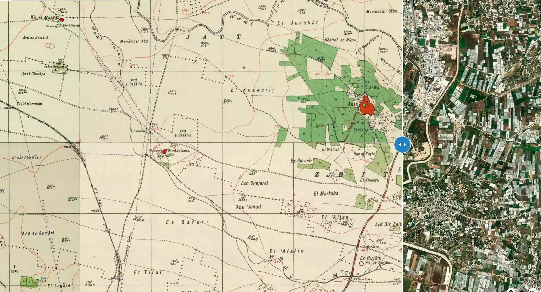
| Before & After Nakba, Click Map For Details |
|||||||||||
|
|||||||||||
| Map Location | See location #6 on the map View from satellite |
||||||||||
| Military Operation | Coastal Clearing | ||||||||||
| Exodus Cause | Expulsion by Zionist troops | ||||||||||
| Village Temains | al-Jalama was completely obliterated, and only house rubble remains. | ||||||||||
| Ethnically Cleansing | al-Jalama was initially inhabitants were intimidated into fleeing by the Haganah on February 8th, 1948, and it was completely evacuated on April 1st, 1948. | ||||||||||
| Population |
|
||||||||||
| Town's Name Through History | The Crusades referred to al-Jalama by Gelenne. | ||||||||||
| Inhabitants Place of Origin | Villagers originally migrated from 'Attil, Tulkarm (currently, in the occupied West Bank). | ||||||||||
| Nearby Wadies & Rivers | The village was situated nearby the East banks of Wadi Jalama. | ||||||||||
| Exculsive Jewish Colonies Who Usurped Village Lands |
Lahavot Chaviva occupies some of Jalama's lands. | ||||||||||
Village Before NakbaThe village stood on a small, low hill on the coastal plain, and overlooked the area known as Raml ("sand of”) Zayta, to the west. Wadi Jalama passed by the southwestern edge of the hill on which the village was situated. Al-Jalama was 3 km west of the Tulkarrn-Haifa highway and was linked to it by a secondary road. It was about 1 km east of the Tulkarm-Haifa railway. Dirt paths linked the village to neighboring villages. Khirbat al-Jalama was known during the Crusader period as Gelenne. The Mamluk sultan, Baybars, is said to have made a grant of the village land to his lieutenants in A.D. 1265, dividing it equally among three amirs (military commanders).The modern al-Jalama was originally a farm that belonged to the inhabitants of Attil, who had settled on the farmland in the vicinity of their village. The number of inhabitants was twenty-nine in 1922 and had grown to seventy by 1945. The village was built on an archaeological site, and some of the stone remains from the site were incorporated into the village houses. Most of the houses were constructed of stone and mud, although cement was used for some of them during the 1930s and 1940s. They were clustered close together in the village center but were dispersed at the periphery. The residents of al-Jalama were Muslims. They obtained water for their domestic needs from a well that was located 500 m east of the village on the east bank of Wadi Jalama. Grain, vegetables, watermelons, and oranges were grown on the village lands. Some of the crops were rainfed while others were irrigated from wells. Village Occupation and Ethnic CleaningThe approximate date of the occupation of al-Jalama can be determined by examining the events in the villages in the vicinity. The nearby village of Qaqun was first attacked in early March 1948, but it was not occupied until three months later. The History of the Haganah implies that by early May, Qaqun was the last village to remain unoccupied in this area, and it held out until it was wrested from Iraqi forces the following month. While al-Jalama may have suffered the same fate at that time, it probably was occupied before then, in the context of 'clearing' the coastal plain north of Tel Aviv, around the time of the first attack on Qaqun in March.Zionists Colonies on Village LandsThere are no Israeli settlements on village lands. The settlement of Lahavot Chaviva, built in 1949 less than 0.5 km north of the village site, is on land that belonged to the village of Zayta (now on the West Bank).Village TodayPiles of stones and terraces on the hill, along with a lone fig tree, provide the only evidence that a village formerly occupied the site. Cactuses, wild grass, and thorns also grow on parts of the site.SourceDr. Walid al-Khalidi, 1992: All That Remains. |
|||||||||||
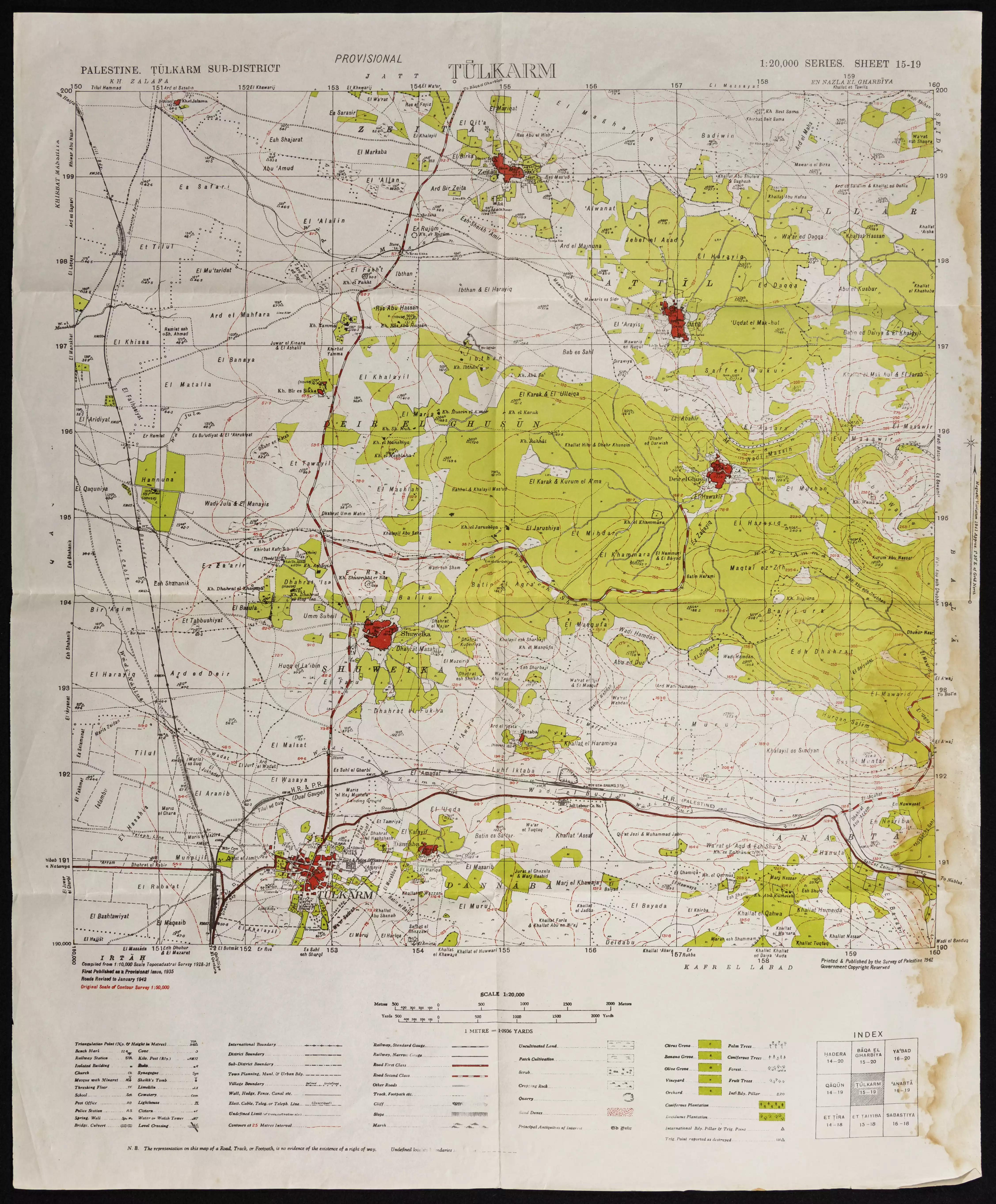
| Related Maps | Town Lands' Demarcation Maps خرائط للقضاء توضح حدود القرى والاودية Town's map on MapQuest View from satellite Help us map this town at WikiMapia |
||||||||||
| Related Links | Wikipedia's Page Google Search Google For Images Google For Videos |
||||||||||
| More Information | في كتاب كي لا ننسى في كتاب بلادنا فلسطين المزيد من موقع هوية |
||||||||||
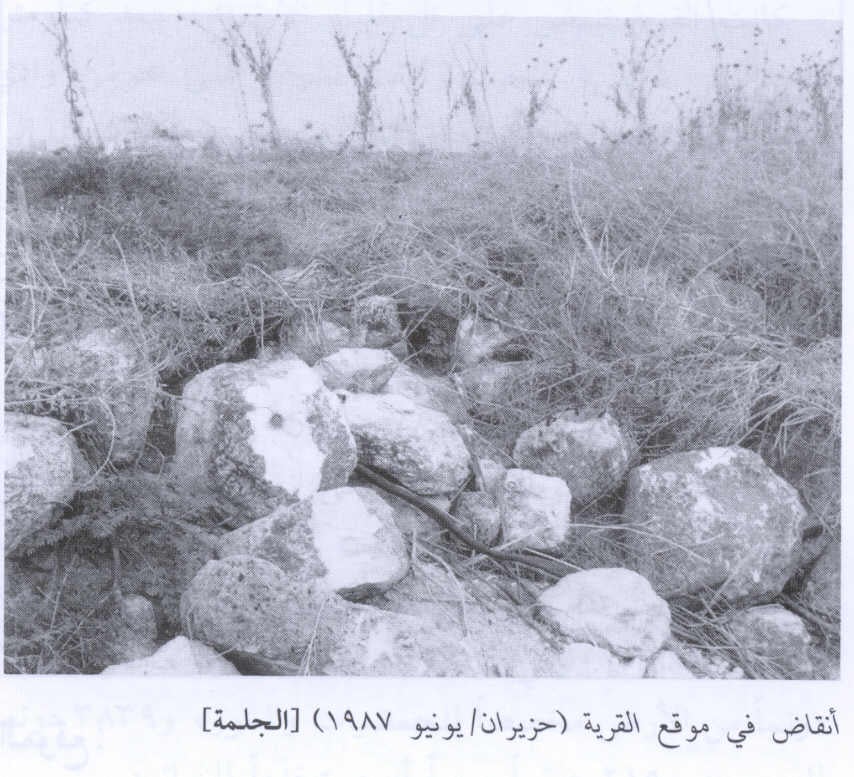
- Rubble on the village site, 1987
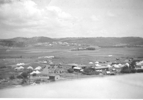
Scanned from "All That Remains" by Dr. Walid Khalidi - view from Palestine Police Post February 1948
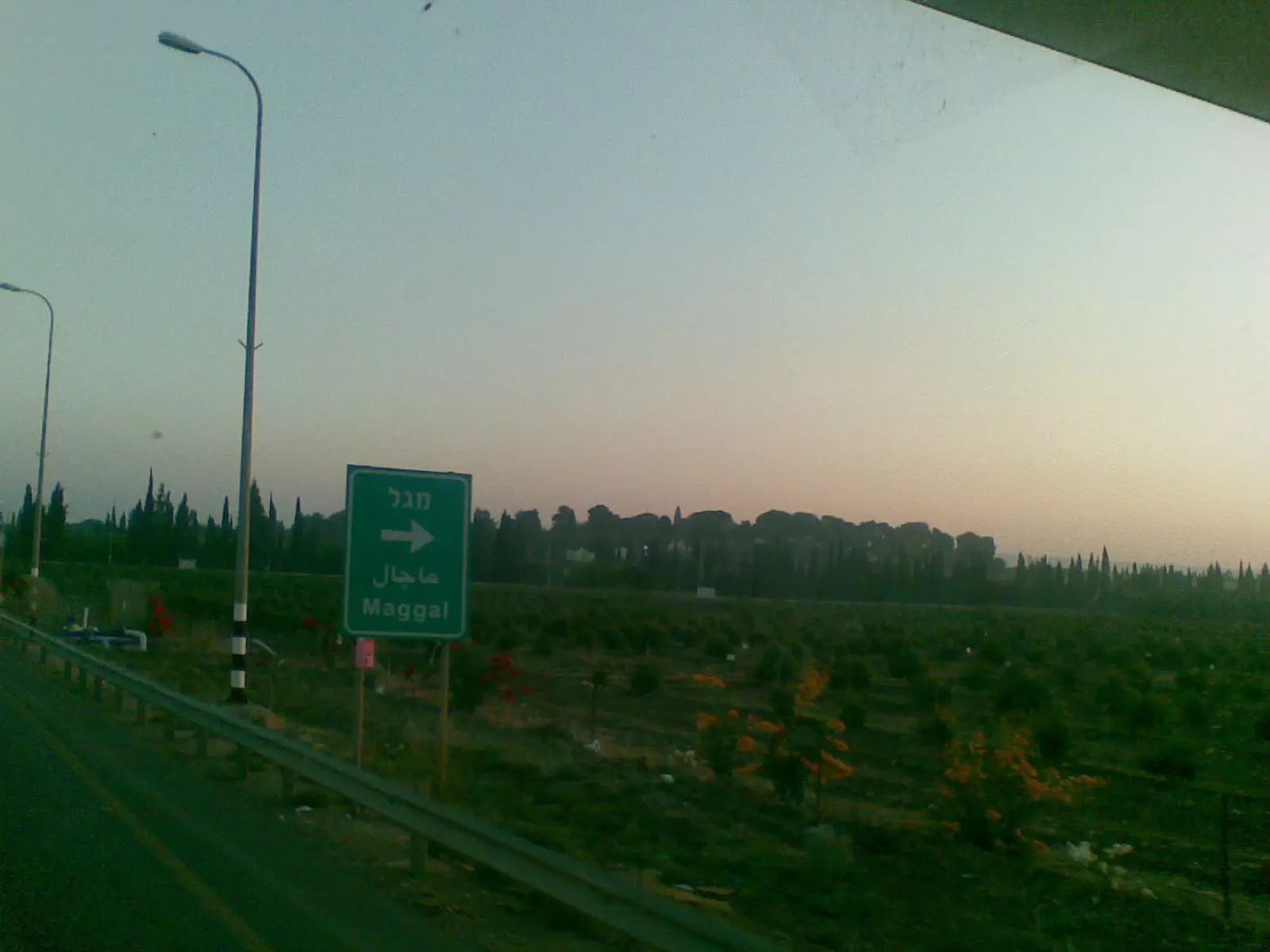
Posted by Robert McCann 3 - كيبوتس ماجال على اراضي القريه
Posted by ابو الثائر - خارطة تُظهِر الحدود والطرق بأنواعها والأماكن المقدسة والطبيعة الطوبغرافية من تلال وسهول ومنحدرات والتشكيلة الطبيعية للأرض وأنواع المزروعات. نُشرت الخريطة فترة الانتداب البريطاني، تم إضافة تعديلات عليها من قِبَل خدمة الخرائط والصور التابعة للقوات العسكرية الاسرائيلية فترة الأربعينيات.
Want to browse more? 80,000 pictures were grouped in these gallaries:
| Display Name | Clan/Hamolah | Country of Residence |
| Hussein | Younes - Al-Fukaha' | Central, Saudi Arabia |
No links have been shared yet, be free to the first to share the first link.
 Fake Valor: Why Did Zionist Jews Hoist Nazis Flag on Their Ships in the 1930s?
What is new?
-
Facts About Oct. 7th Gaza Raid
-
Remined Us Please:: Who Did Rape Who? Palestinians Raped Israelis? Or, was the other way around?
-
When Prof. Edward Said was invited to debate Bibi Netanyahu in the 1980s, watch what happened!
-
Ezra Klein of the NY Times on the "Jewish Race".
-
Abusing Blood Libel!
-
Did Israeli Soldiers Activate The Hanniba Direective On Oct. 7th? You Be The Judge
-
Zionist FAQ: Isn't it true that Palestinians don't want peace? Palestinians never accepted the two-state solution
- Facts about Haavara (Transfer) Agreement between Ben-Gurion & Hitler
-
Haavara FAQs: Why Did Zionist Jews Hoist Nazis' Flags on Their Ships in the 1930s?
- Haavara FAQs: When Chaim Weizmann met FDR in mid-1943, why was he silent about rescuing European Jewry?
-
Dear ChatGPT: How did Palestinians resist Napoleon's invasion of their country in 1799?
-
Dear ChatGPT: Gaza had a vibrant Jewish community in the mid-17th century. What happened to them?
-
Dear ChatGPT: Why did the Jewish Agency suppress news of the Holocaust during WWII?
-
Video Playlist: Jews share their DNA tests to end the conflict for good.
-
A Tale of Two Conflicts: Examining the Definition of Genocide
-
Prof. Abraham Polak And The Suppressed History of the Khazars and European Jewry
-
How Ronald Reagan would have framed the genocide in Gaza if he were still alive?
-
Haavara FAQs: Let us do the math: how many German Jews did The Haavara Agreement save?
-
Zionist FAQs: The Hebron Massacre of 1929, "clearly proves" that Palestinians are antisemitic, how could you deny it?
-
Zionist FAQs: Why Anti-Zionist Is Not Antisemitism?
-
Zionist FAQs: Isn't it true that the KGB created Palestinian Nationalism in the early 1960s?
- Zionist FAQs: Muslims are killing Muslims all the time; why are Israeli Jews being singled out in the media?
- Zionist FAQs: How is Israel an apartheid state when 20% of its citizens are Arabs who enjoy full rights?
-
Haavara FAQs: Why Did Dorothy Thompson Flip From A Zionist Advocate to A Silenced Dissenter?
-
Haavara FAQs: Analysis of Herzl's Uganda Scheme and how it could have saved millions of Jews.
-
Haavara FAQs: Why did Hayim Greenberg describe American Jewry as "morally bankrupt" in early 1943?
-
Haavara FAQs: What if the Evian Conference was a resounding success? What would have been the impact of saving European Jewry on Zionism?
- Haavara FAQs: What if the six million were saved, how that would have impacted the Zionist project?
-
Haavara FAQs: How did Zionist leaders react when Europe's Jews lingered in the DP camps after WWII ended?
-
Why does the American Jewish community repeat lies that David Ben-Gurion had debunked before he died?
-
Who has the power to rename the Tatar/Khazar Gene Marker to Jewish IV?
-
Zionist FAQs: Why won't Egypt, Syria, and Jordan take their people back? Jews are indigenous to Palestine, and Arabs immigrated after Jews developed the country. Arabs should leave.
-
Haavara FAQs: Did Hitler and the Nazis conflate between Judaism and Zionist? If that wasn't case, then why?
-
Haavara FAQs: Winston Churchill and antisemitism, a collection of articles written Churchill.
-
Haavara FAQs: Broken by country, how many Jews survived vs. killed during the Holocaust?
-
Haavara FAQs: Why did European Jews vote with their feet and to immigrated to the Americas, not Palestine, after WWII?
-
Watch this American Jewish Girl describing Israeli Jews' cognitive dissonance like no other in under two minutes
-
Haavara FAQs: When the Nazis went out of their way to hide the Holocaust, Israeli Jews did the exact opposite by broadcasting their genocide of Gazans. But why?
-
Haavara FAQs: How Zionist Jews went out of their to show their appreciation to Nazism and Fascism?
- Haavara FAQs: Why Zionist leaders were against bombing the death camps & the Railroads leading to them?
-
Haavara FAQs: Hitler's message to the British and American people: If Jews are such noble citizens and you care about them, how come you're not letting them in? I will gladly ship them to you at my expense, even on luxury liners!
-
A shortlist of Zionist and Israeli false flag operations in the name Jews.
-
The Most Moral Army
- The Land of Kapos (Israel): Where the brave are boycotted and Kapos walk free.
- Why did early Zionists often named their communal enterprises "colonial"?
- Zionist Relations with Nazi Germany by Faris Glubb
-
Two NY Times advertisements by Zionists in the early 1943 that exposes Zionists' treason at the height of the calamity
- Facts Not Lies about the Palestinian-Israeli Conflict.
- Site's pictures have been categorized
- Campgain Against Lice
- A Survey of Palestine, the official source about Palestine before Nakba produced by the British Mandate; over 1200 pages.
- Satellite View & Google Earth: Over 6,000 placemarks identifying all destroyed towns, W. Bank & Gaza Strip Towns, & refugee camps.
- PalestineRemembered.com and its Nakba Oral History Project were featured on al-Jazeera Satellite TV.
- Nakba Oral History Video Podcast:
 Over 700 Oral History interviews (including 3,500+ hours of recording) can be viewed online.
 - Palestine Village Statistics Project
- Gaza Jail Break
- النسخة العربية للموقع الان متوفرة
- Videos: Documenting the destroyed villages in video: Tracing all that remains since Nakba.
- Videos: Responding to Zionist Propaganda
- Interview: The ethnic cleansing of Palestine: George Galloway interviews Israeli Historian Ilan Pappe.
- For Palestinians, memory matters. It provides a blueprint for their future By George Bisharat.
- Zionist FAQ now available in Hebrew שאלות שציונים שואלים, עכשיו בעברית
- Video: The Stephen Walt and John Mearsheimer report on the influence of the Israel Lobby on U.S. Foreign Policy
- The Palestinian-Israeli conflict for beginners
