| PalestineRemembered | About Us | Oral History | العربية | |
| Pictures | Zionist FAQs | Haavara | Maps | |
| Search |
| Camps |
| Districts |
| Acre |
| Baysan |
| Beersheba |
| Bethlehem |
| Gaza |
| Haifa |
| Hebron |
| Jaffa |
| Jericho |
| Jerusalem |
| Jinin |
| Nablus |
| Nazareth |
| Ramallah |
| al-Ramla |
| Safad |
| Tiberias |
| Tulkarm |
| Donate |
| Contact |
| Profile |
| Videos |
Welcome To 'Iraq al-Manshiyya - عراق المنشية (עיראק אל-מנשיה)
|
District of Gaza
Ethnically cleansed days ago |
العربية Google Earth |
 |
Gallery (60) |
- Statistics & Facts
-
Before & After

- Satellite View
- Articles 16
- Pictures 60
- Aerial Views 3
- Land Deeds 16
- Oral History 5
- Members 62
- All That Remains
- Wikipedia
- Videos 6
- Guest Book 65
- Links
| Statistic & Fact | Value | ||||||||||||||||||
| Occupation Date | March 1, 1949 | ||||||||||||||||||
| Distance From District | 32 (km) North East of Gaza | ||||||||||||||||||
| Elevation | 125 (meters) | ||||||||||||||||||
| Before & After Nakba, Click Map For Details |
|||||||||||||||||||
|
|||||||||||||||||||
| Pre-Nakba Aerial View |
|||||||||||||||||||
|
|||||||||||||||||||
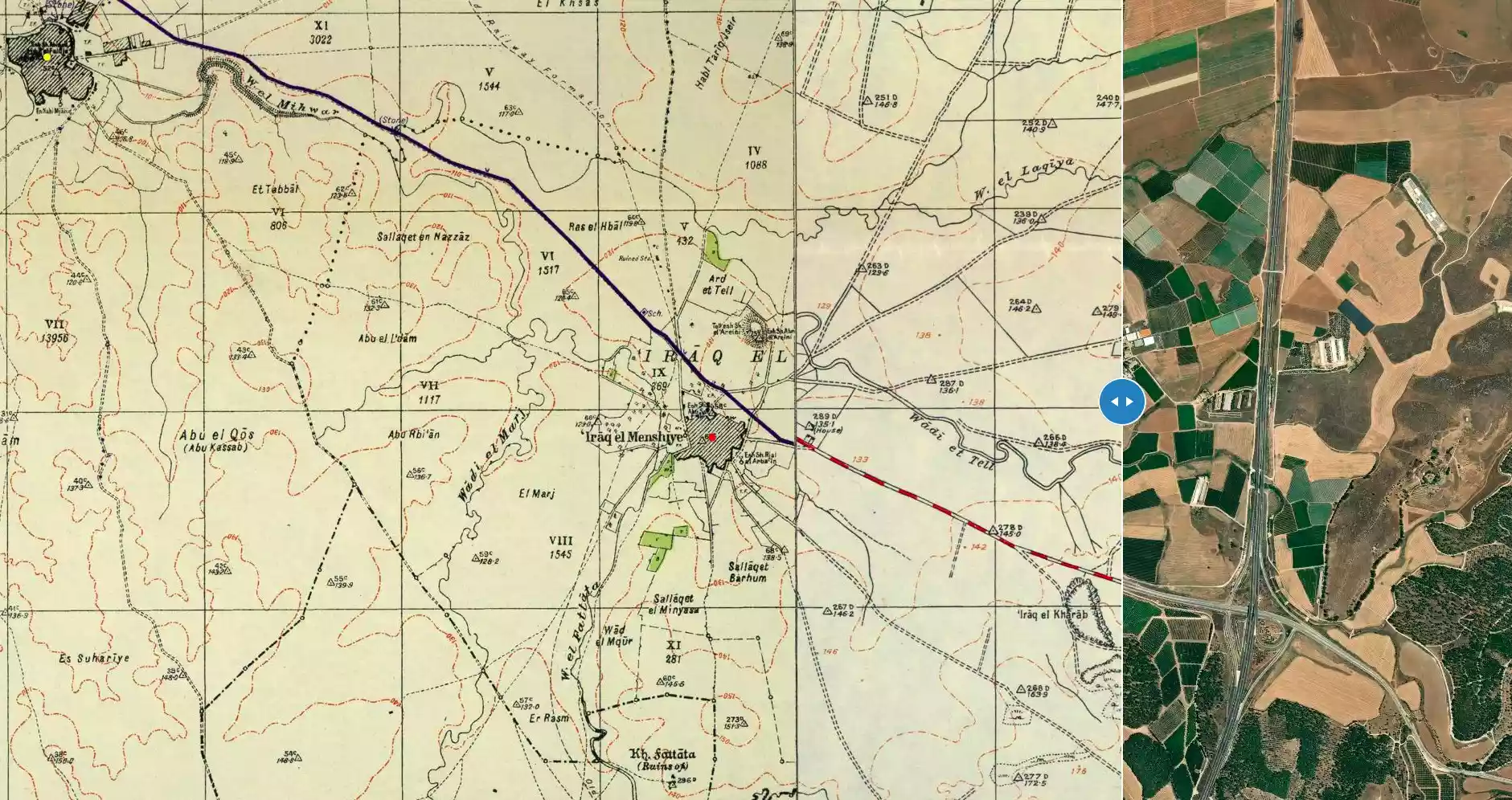
| Map Location | See location #34 on the map View from satellite |
||||||||||||||||||
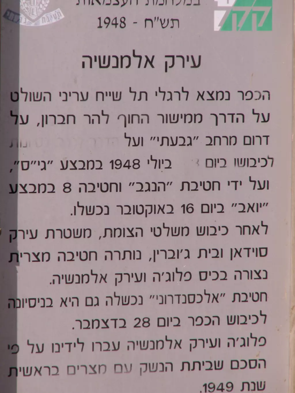
| Military Operation | Operaion Yo'av | ||||||||||||||||||
| Attacking Units | Alexandroni Brigade | ||||||||||||||||||
| Defenders | Egyptian Army | ||||||||||||||||||
| Exodus Cause | Expulsion by Zionist troops | ||||||||||||||||||
| Village Temains |
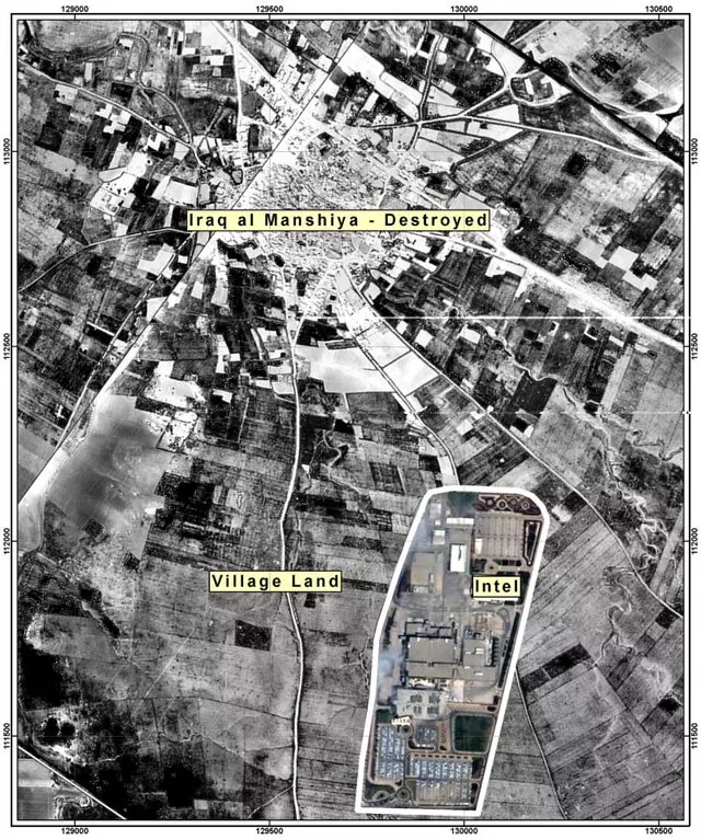
The village was obliterated. It should be noted that Intel Corporation (the semiconductor giant) maintains & operates one of its biggest manufacturing plants outside the US (FAB 18) on a looted land. We demand restitution for the dispossessed Palestinian refugees who happens to be just few miles to the East in the slums of the Gaza Strip. Such right has been granted to these refugees base on United Nation resolution 194, which it clearly stated that the Palestinian refugees should have The Right Of Return, & the right to be compensated for any lose of properties. |
||||||||||||||||||
| Ethnically Cleansing | 'Iraq al-Manshiyya inhabitants were completely ethnically cleansed. Please see the Stories & Memories section for detail account of the village cleansing. | ||||||||||||||||||
| Pre-Nakba Land Ownership |
**Town Lands' Demarcation Maps |
||||||||||||||||||
| Land Usage As of 1945 |
|
||||||||||||||||||
| Population |
|
||||||||||||||||||
| Number of Houses |
|
||||||||||||||||||
| Near By Towns |
|||||||||||||||||||
|
|||||||||||||||||||
| Schools | 'Iraq al-Manshiyya had an elementary school for boys which was founded in 1934, and in 1945 it had an enrollment of 201 students. | ||||||||||||||||||
| Places of Warship | The village had two mosques, one was old and the other was more recent which was considered one of the most handsome among village mosques; it contained several rooms, a portico,and a courtyard. | ||||||||||||||||||
| Shrines / Maqams | The village had a shrine for al-Shaykh Abroad al-'Urayni | ||||||||||||||||||
| Water Supply | The village had three wells which supplied it with its water needs. | ||||||||||||||||||
| Exculsive Jewish Colonies Who Usurped Village Lands |
Qiryat Gat and Sde Moshe | ||||||||||||||||||
| Featured Video | |||||||||||||||||||
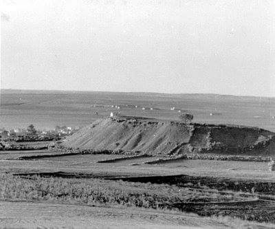
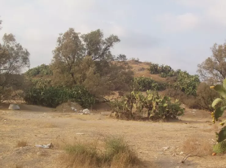
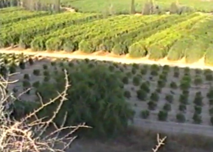
Village Before NakbaThe village was situated in an area of rolling hills, where the coastal plain and the foothills of the Hebron mountains merged, and was bordered on the western side by Wadi Fattala. It was on the south side of the highway between al-Faluja, to the northwest and Bayt Jibrin (an important village in the Hebron sub-disctrict), to the east. Its name, Iraq al-Manshiyya, expressed both the geography and history of the village. The first part, Iraq ('small hill' in Arabic), referred to the topography. The second part, al-Manshiyya ('the built one' in Arabic), was added by the inhabitants to distinguish it from a nearby village, also known as Iraq, from which they had moved. In 1596, Iraq al-Manshiyya was a village in the nahiya of Gaza (liwa' of Gaza), with a population of sixty-one. It paid taxes on a number of crops, including wheat and barley, as well as on other types of produce such as goats and beehives.In the late nineteenth century, the village of Iraq al-Manshiyya was built of adobe bricks and surrounded by arable land. The village had a radial plan, with its smaller streets branching out from the intersection of the two perpendicular main streets. The intersection of these two streets formed its center. Three wells supplied the village with water for domestic use. As the village grew, it expanded toward the highway and northeastward in the direction of Tall al-Shaykh Ahmad al-Urayni. This large mound, some 32 m high, rose to the north of the village, and on its summit was a religious shrine for Shaykh Ahmad al-Urayni. Iraq al-Manshiyya's Arab population was Muslim. It had an old mosque and a more recent one that was considered one of the most handsome among village mosques; it contained several rooms, a portico, and a courtyard. The village also had an elementary school, founded in 1934, with an enrollment of 201 students in the mid-1940s. The inhabitants worked primarily in agriculture, growing grain, grapes, and many varieties of trees (such as olive and almond trees). Agriculture was mostly rainfed, despite the availability of groundwater, especially along the line where the plain intersected with the nearby foothills. In 1944/45 a total of 13,449 dunums was allotted to cereals; 53 dunums were irrigated or used for orchards. Goats and sheep supplied the materials (hair and yarn) needed for rug weaving. The villagers dyed their rugs in al-Faluja, where they also went for medical treatment and other services. The mound next to Iraq al-Manshiyya was for some years erroneously identified with the biblical (Philistine) city of Gath. However, when the site was excavated (1956–1961) no traces of a Philistine presence were found. These excavations (and later work in 1984) determined that a settlement had been established there in the fourth millennium B.C. and had been occupied until the second century B.C. The tell contains the ruins of this settlement. As is the case for many sites in Palestine, its later history continued on a new location below this tell—that is, on the site of Iraq al-Manshiyya. Village Occupation and Ethnic CleaningThe Giv'ati Brigade unsuccessfully attempted to occupy the village at the end of July 1948 during the second truce of the war, according to Israeli historian Benny Morris. The New York Times reported on 28 July that Israeli forces were attacking Egyptian communications and vehicle concentrations at Iraq al-Manshiyya. Two days later, a dispatch spoke of 'rather serious engagements between Hatta and Iraq el Manshiya.' Palestinian historian Aref al-Aref writes that the village was the target of 'continuous attacks' during the second truce, notably on 22 August.A large-scale attempt was made to occupy the village when the second truce ended, at the beginning of Operation Yoav , on 16 October. This time, the Israeli army was beaten back decisively by Egyptian forces, but not before an armored column succeeded in storming the village. An Israeli spokesman quoted in the New York Times said that in forcing its way into Iraq al-Manshiyya, 'the Israeli Army shot up the village, killed a number of Egyptians and destroyed dumps and guns….' The spokesman described the attack as a 'punitive raid' and admitted losing three tanks. A final assault was executed on 27–28 December by units of the Alexandroni Brigade, which managed to enter the village only to be driven out again by Egyptian reinforcements. At the end of the war, the village was located inside the 'Faluja pocket,' an enclave in which 3,000 Palestinian civilians and one Egyptian Brigade (one of whose officers was Egypt's future president, Gamal Abdel Nasser) were trapped. Morris says that within days of signing the Israel–Egypt armistice agreement, on 24 February 1949, Israel violated its terms by intimidating into flight the 2,000–3,000 villagers of Iraq al-Manshiyya and neighboring al-Faluja. According to the United Nations mediator, civilians in the enclave had been beaten and robbed by Israeli soldiers; cases of attempted rape were reported. Morris reports that the decision to intimidate the population into fleeing their villages was probably taken by the Israeli commander of the southern front, Yigal Allon, probably with the approval of Prime Minister David Ben-Gurion. Zionists Colonies on Village LandsA kibbutz named Gat was established in 1941 on lands that traditionally belonged to the village; it took over additional lands in 1949 after the expulsion of the villagers. Six years later, in 1954, Qiryat Gat was established on village lands; Sde Moshe was established in 1956 on village land east of the village site.Village TodayA forest of eucalyptus has been planted on the site, and two signs, each in both Hebrew and English, identify it as the "Margolin Peace Forest." Only traces of the village streets remain, along with scattered cactuses. Part of the surrounding land is cultivated by Israeli farmers.SourceDr. Walid al-Khalidi, 1992: All That Remains. |
|||||||||||||||||||
| Related Maps | Town Lands' Demarcation Maps خرائط للقضاء توضح حدود القرى والاودية Town's map on MapQuest View from satellite Help us map this town at WikiMapia |
||||||||||||||||||
| Related Links | Wikipedia's Page Facebook Page Google Search Google For Images Google For Videos |
||||||||||||||||||
| More Information | في كتاب كي لا ننسى في كتاب بلادنا فلسطين في كتاب النكبة والفردوس المفقود المزيد من موقع هوية |
||||||||||||||||||
- كتاب الخروج من قرية عراق المنشية المهجرة -- إعداد اروى موسي هشهش
- Benny Morris's book cover which documents the cleansing of Palestine (2nd)
- al-Faluja & 'Iraq al-Manshiyya Ethnic Cleansing Based On Declassified Israeli Documents by Benny Morris 1
- al-Faluja & 'Iraq al-Manshiyya Ethnic Cleansing Based On Declassified Israeli Documents by Benny Morris 2 (2nd)
- al-Faluja & 'Iraq al-Manshiyya Ethnic Cleansing Based On Declassified Israeli Documents by Benny Morris 3 (2nd)
- al-Faluja & 'Iraq al-Manshiyya Ethnic Cleansing Based On Declassified Israeli Documents by Benny Morris 4 (2nd)
- SFGate: Intel chip plant located on disputed Israeli land By Henry Norr
- معركة عراق المنشية - 27-28 كانون أول 1948 - للأستاذ عارف العارف
- حصار الفلوجة - للأستاذ عارف العارف
- فلسطينيون يستذكرون حصار عبد الناصر في عراق المنشي
- لاجئو فلسطين يورثون أبناءهم الهوية ومفاتيح البيوت القديمة
- The Nakba, Intel, and Kiryat Gat Henry Norr, The Electronic Intifada
- قصة معركة عراق المنشية../ د.مصطفى كبها
- سيرة رجل من القريه
- ذكرى النكبة.. قصص انكسار وانتصار
- نبذة تاريخية عن قرية عراق المنشية (قضاء غزة) من كتاب (كي لا ننسى)
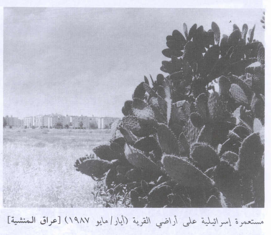
- General View Of The Destroyed Village In 1987
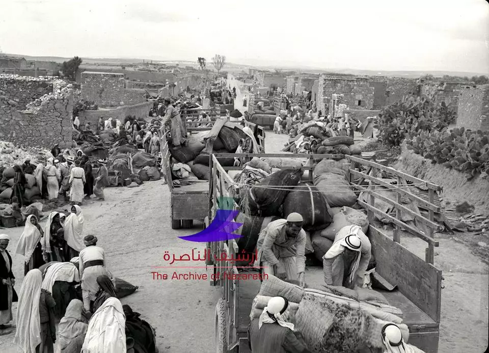
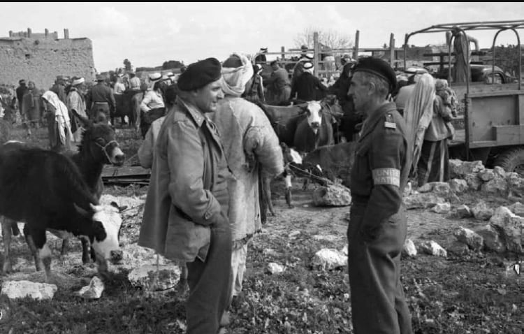
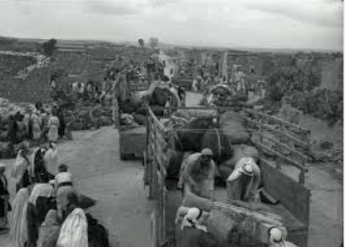
Scanned from "All That Remains" by Dr. Walid Khalidi 2 - A RARE picture showing the people of Iraq al-Manshyya as they are being ethnically cleansed in April 1949
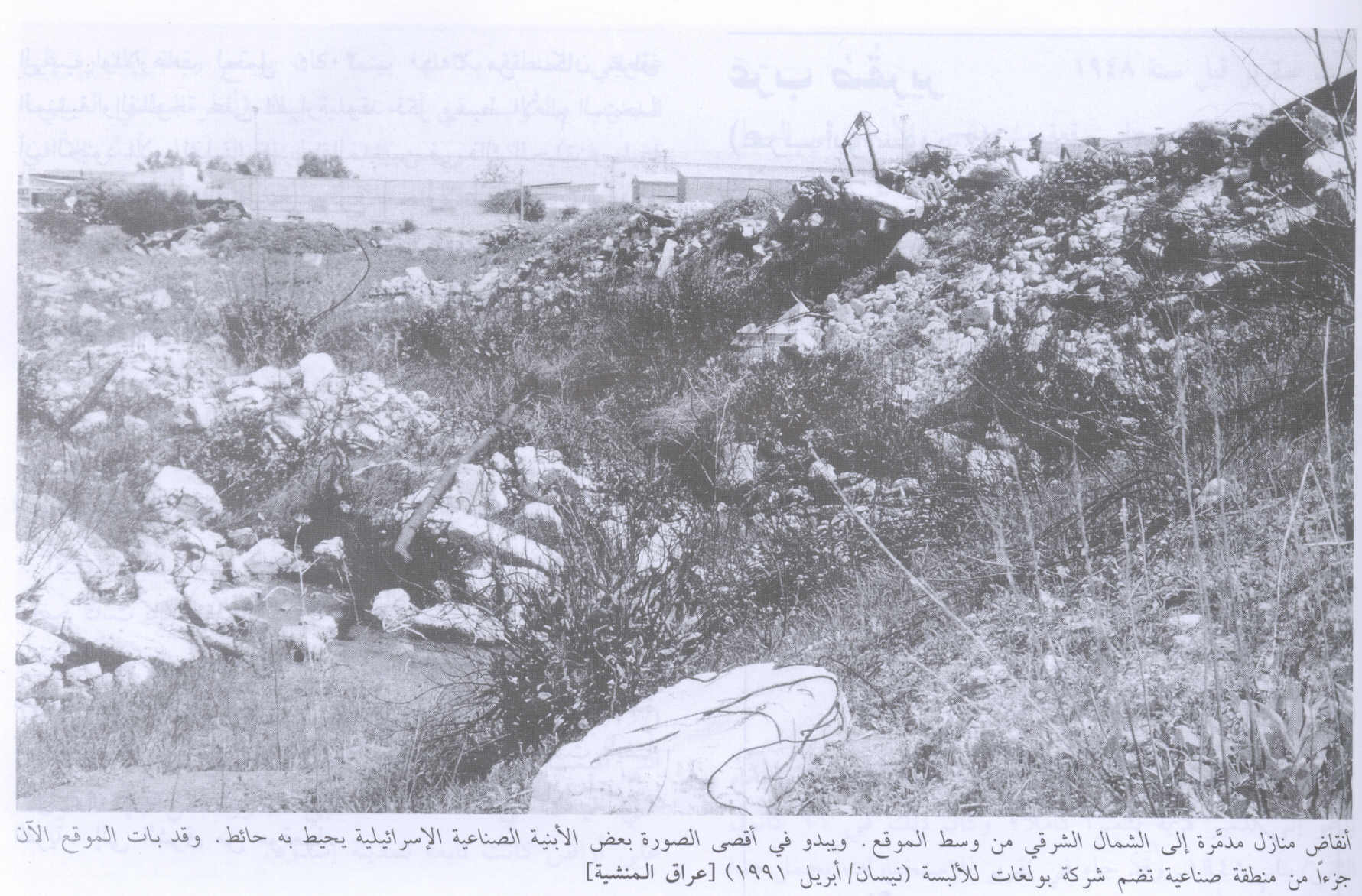
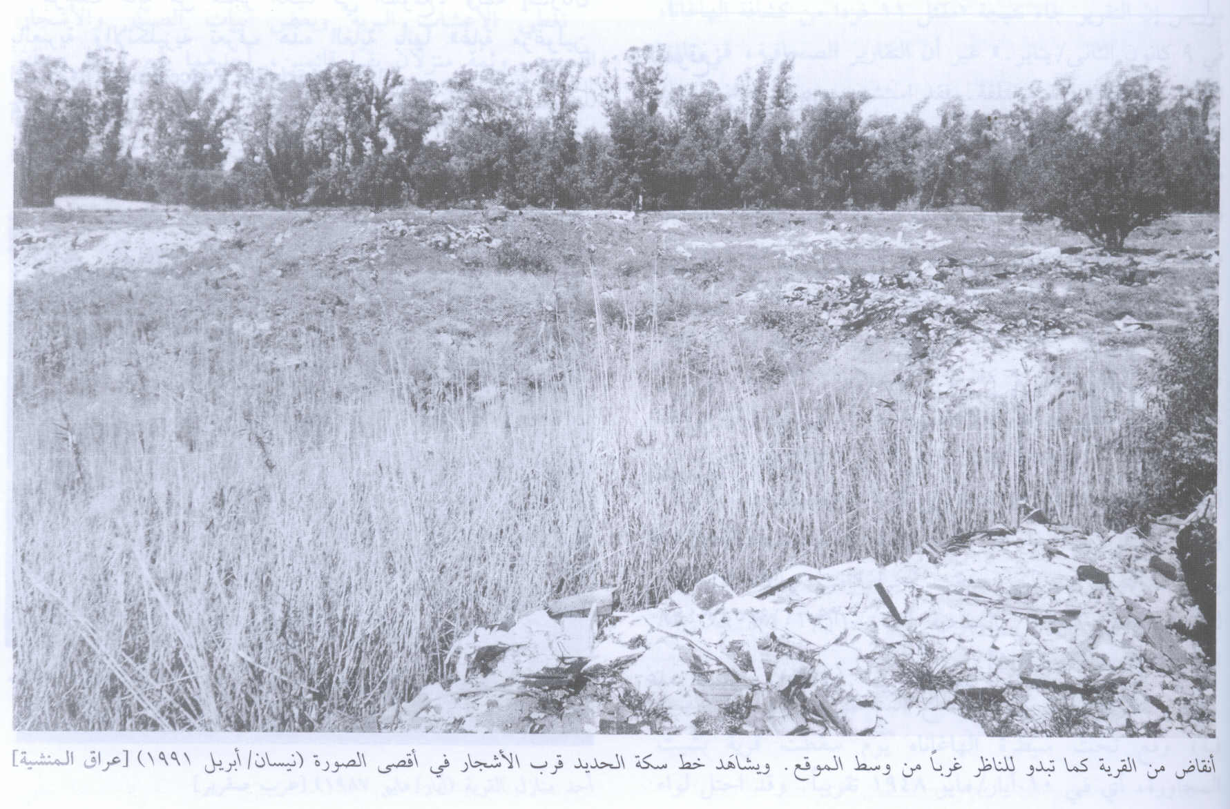
1 - Rubble Of The Destroyed Village In 1991
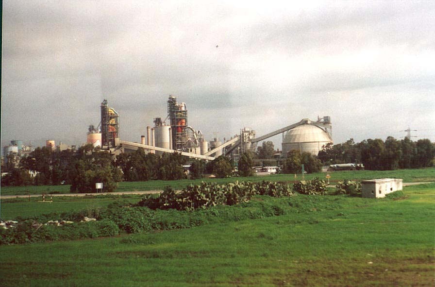
Scanned from "All That Remains" by Dr. Walid Khalidi 7 - Aerial view of Iraq Manshiyya shoing exactly were Intel's FAB-18 factory located on Palestinian looted lands
1 - Rubble Of The Destroyed Village 2 In 1991
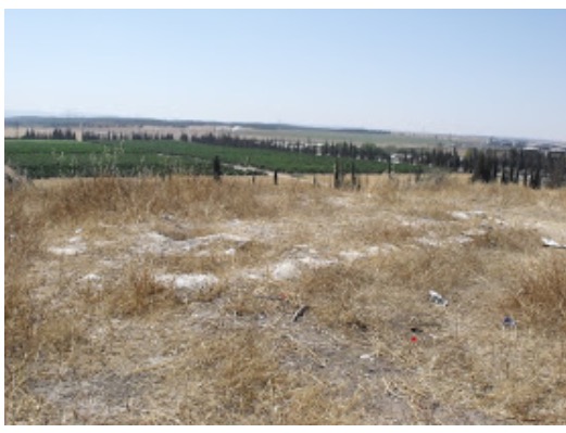
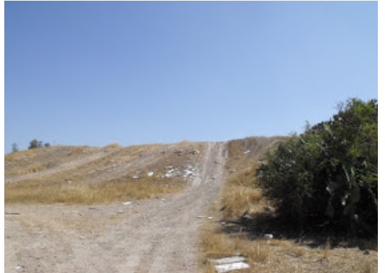
Scanned from "All That Remains" by Dr. Walid Khalidi 6 - General view of the village site, 2000
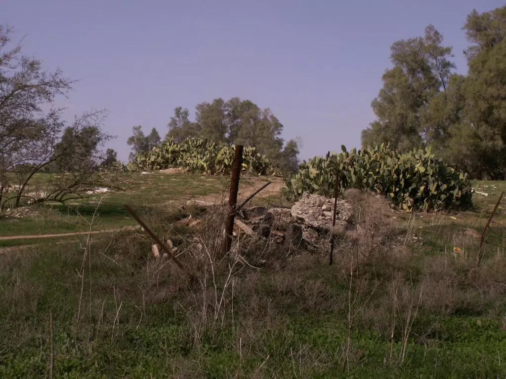
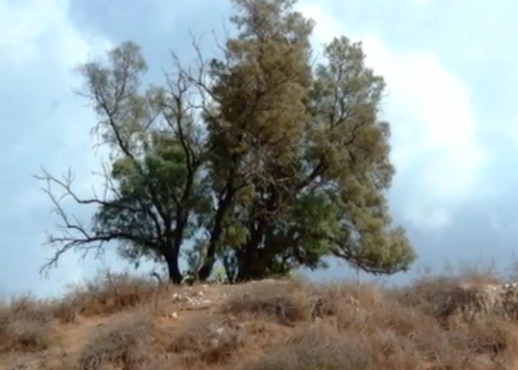
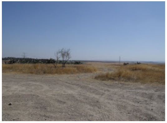
9 - Remains of a building, sycamore trees and cacti, near Tell AlUrani
Posted by Uri Zackhem 6 - Near Tall ElUrani, commemorating Givati attacks on the village

Posted by Uri Zackhem 1 - Near Tall ElUrani, commemorating Givati attacks and that it was awarded to Israel according to the armistice with Egypt.
Posted by Uri Zackhem 3 - عراق المنشيه

Posted by محمد ألأعسم 12 - Tamarisk and cacti, Tel ElUrani

Posted by Uri Zackhem 8 - From Tel El'Urani, the view of Kiriat Gat. 27/09/08

Posted by Uri Zackhem 1 - Cacti hedgerows and the modern town, 27/09/08

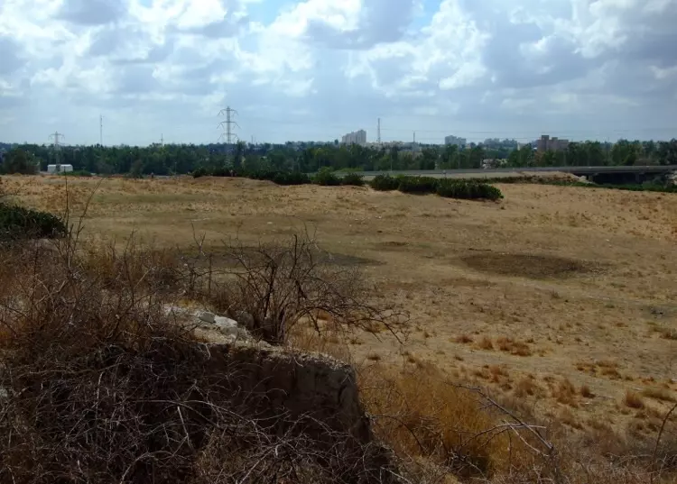
Posted by Uri Zackhem 1 - Razed structure and a view northward from the hill.

Posted by Uri Zackhem 3 - Looking southeast from the hill the industrial zone is located on the village. 27/09/08

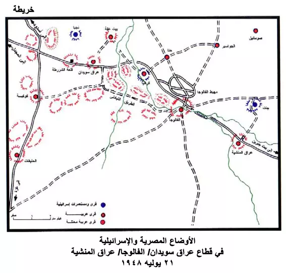
Posted by Uri Zackhem 6 - خريطة تظهر بعض القرى منها عراق المنشية
Posted by حنظلة 1 - قصة قصيرة عن عراق المنشية

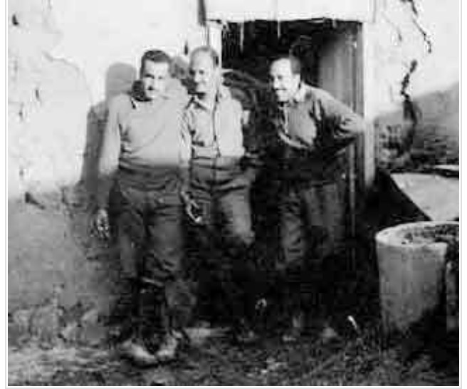
Posted by حنظلة 3 - مختار عراق المنشيه الحاج خالد حمدان الطيطي

Posted by ABU KHALED 7 - مختار عراق المنشيه الحاج خالد حمدان الطيطي

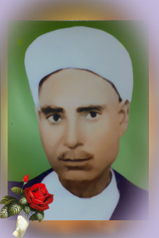
Posted by ABU KHALED 1 - الشيخ حسن محمد ابوريا- من المتعلمين في البلد, لمعرفة المزيد الرجوع الى سيرة رجل من القرية.
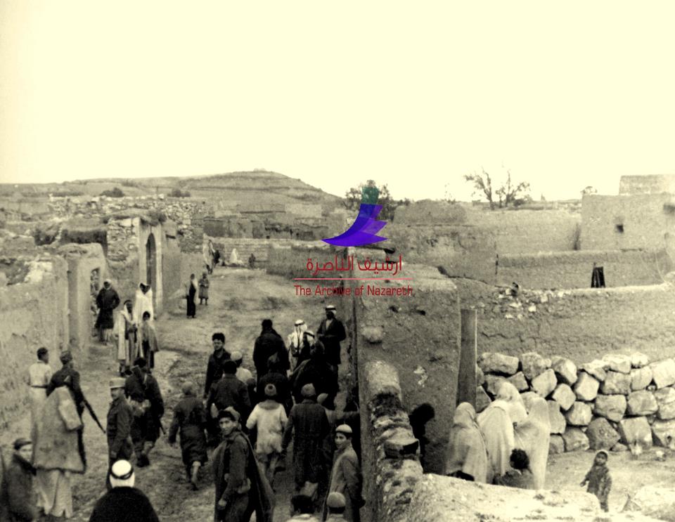
Posted by جبرحسن محمد ابوريا 2 - منظر عام في القرية قبل النكبة (أرشيف الناصرة)
- صورة التقتطت لتهجير قرية عراق المنشية عام 1948.! منقول من صفحة أحمد مروات
- شجرة عائلة الطيطي
2 - الحاج سالم محمد سالم عةض الاه الجوابرة على تلة الشيخ العريني في العراق

1 - تلة العريني عام 1940
- عراق المنشيه
Posted by abu raya - بيارات عراق المنشيه
Posted by abu raya - عراق المنشيه
Posted by abu raya - عراق المنشيه

Posted by abu raya - عراق المنشيه
Posted by abu raya - عراق المنشيه
Posted by abu raya - صوره قديمه ليوم تهجير اهالي عراق المنشيه
Posted by abu raya - صوره قديمه ليوم تهجير اهالي عراق المنشيه
Posted by abu raya - الرىيس الراحل جمال عبد الناصر مع جنوده في عراق المنشيه
Posted by abu raya - عراق المنشيه
Posted by abu raya - عراق المنشيه
Posted by abu raya - عراق المنشيه
Posted by abu raya - عراق المنشيه

Posted by abu raya - منظر جوي لعراق المنشيه سنه 1918

Posted by abu raya - كواشين ارض وفرت لنا غضون مقابلة عبدالقادر الطيطي لتدوين شهادته عن النكبة #8

- كواشين ارض وفرت لنا غضون مقابلة عبدالقادر الطيطي لتدوين شهادته عن النكبة #7

- كواشين ارض وفرت لنا غضون مقابلة عبدالقادر الطيطي لتدوين شهادته عن النكبة #6
- كواشين ارض وفرت لنا غضون مقابلة عبدالقادر الطيطي لتدوين شهادته عن النكبة #5
- كواشين ارض وفرت لنا غضون مقابلة عبدالقادر الطيطي لتدوين شهادته عن النكبة #4
- كواشين ارض وفرت لنا غضون مقابلة عبدالقادر الطيطي لتدوين شهادته عن النكبة #3
- كواشين ارض وفرت لنا غضون مقابلة عبدالقادر الطيطي لتدوين شهادته عن النكبة #2

- كواشين ارض وفرت لنا غضون مقابلة عبدالقادر الطيطي لتدوين شهادته عن النكبة

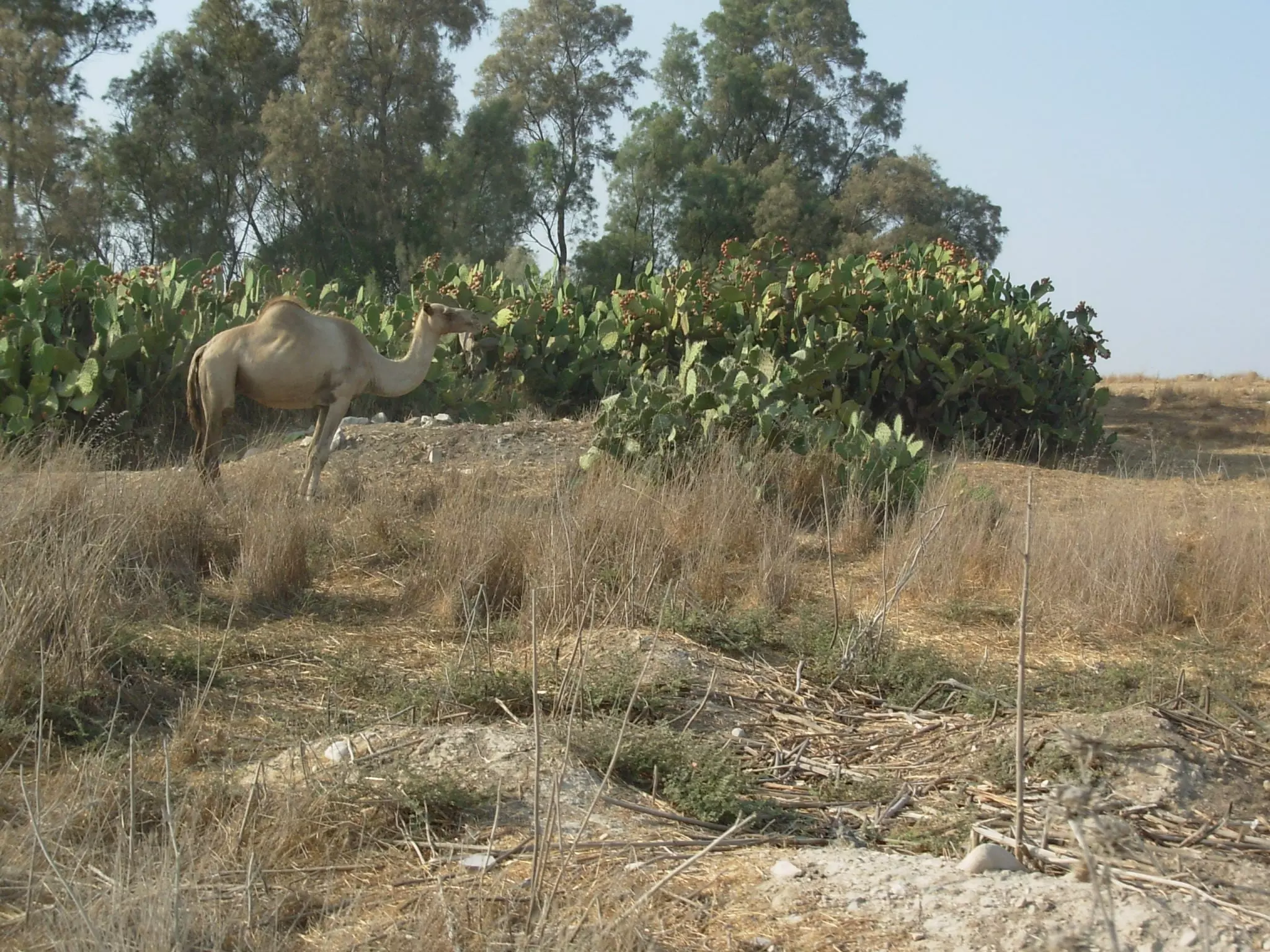
- جمل يشحن نفسه صبراً في عراق المنشية المهجرة (قضاء غزة )
- كوشان ارض (ورقة الطابو) تبثبت ملكية الارض في عراق المنشية لحسن محمد سليمان ابو خيران

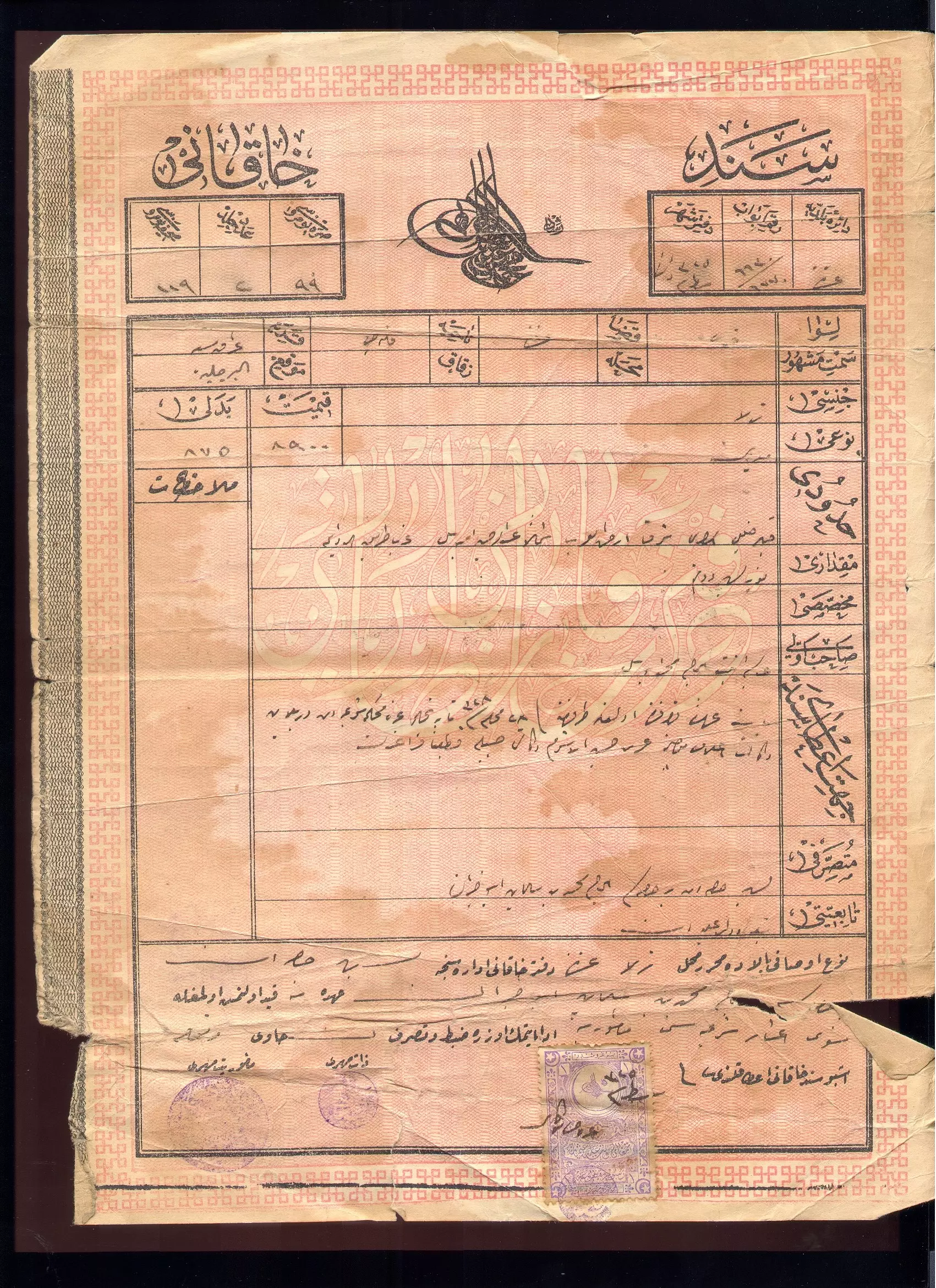
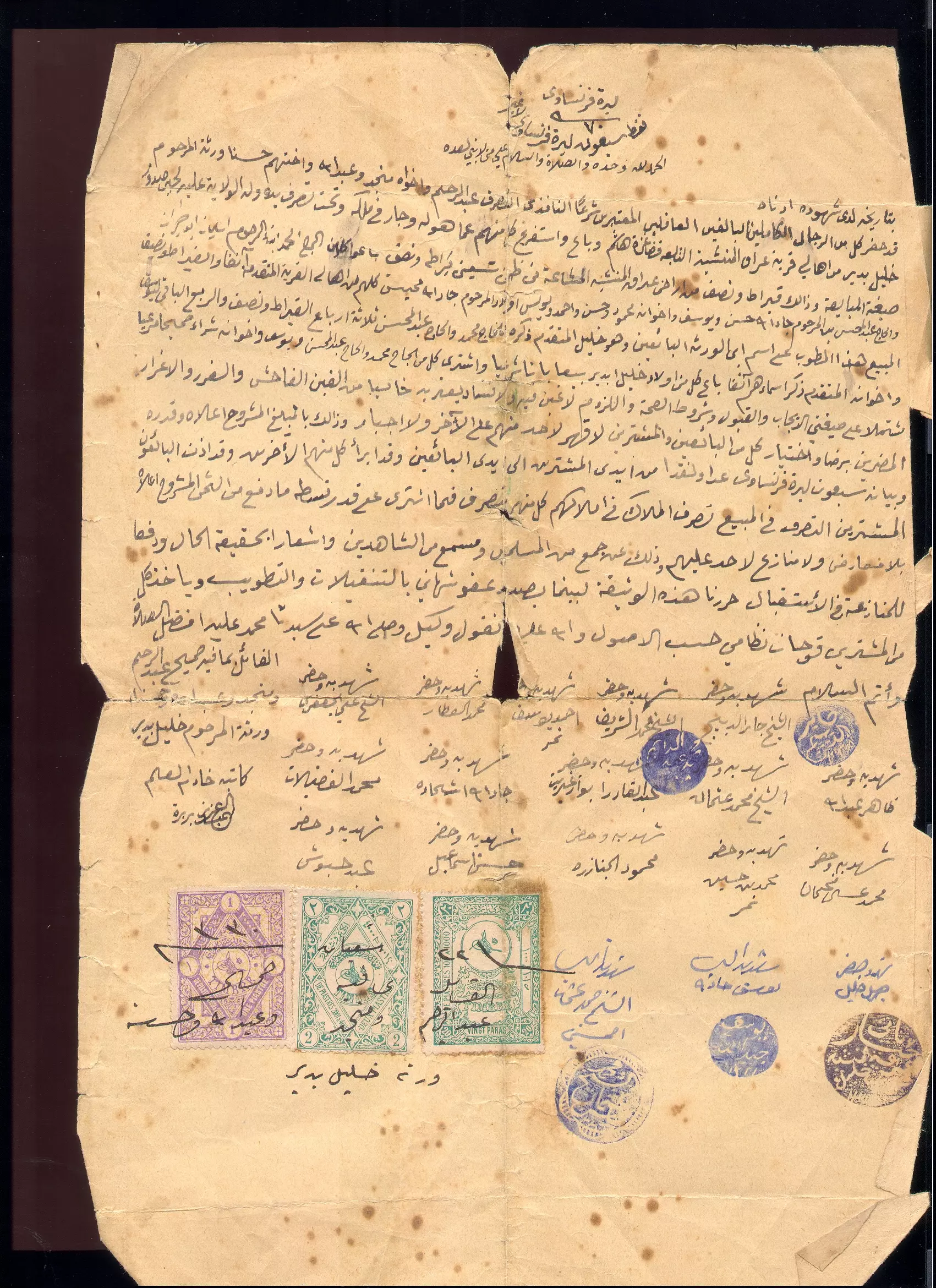
- طابو ارض قديم لاراضي قرية عراق المنشية من فترة الدولة العثمانية.
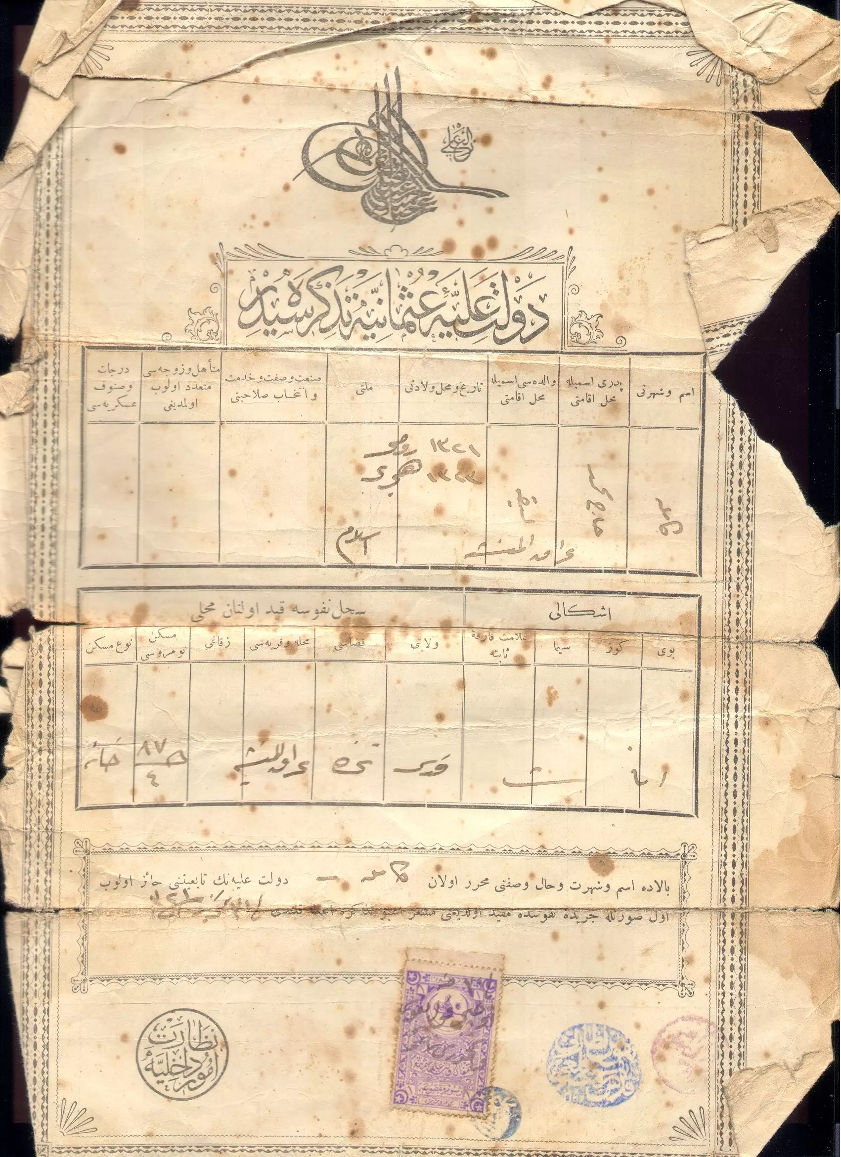
- سند خاقاني : وثائق طابو من الفتر ةالعثمانية عن اراضي قرية عراق المنشية قضاء غزة.
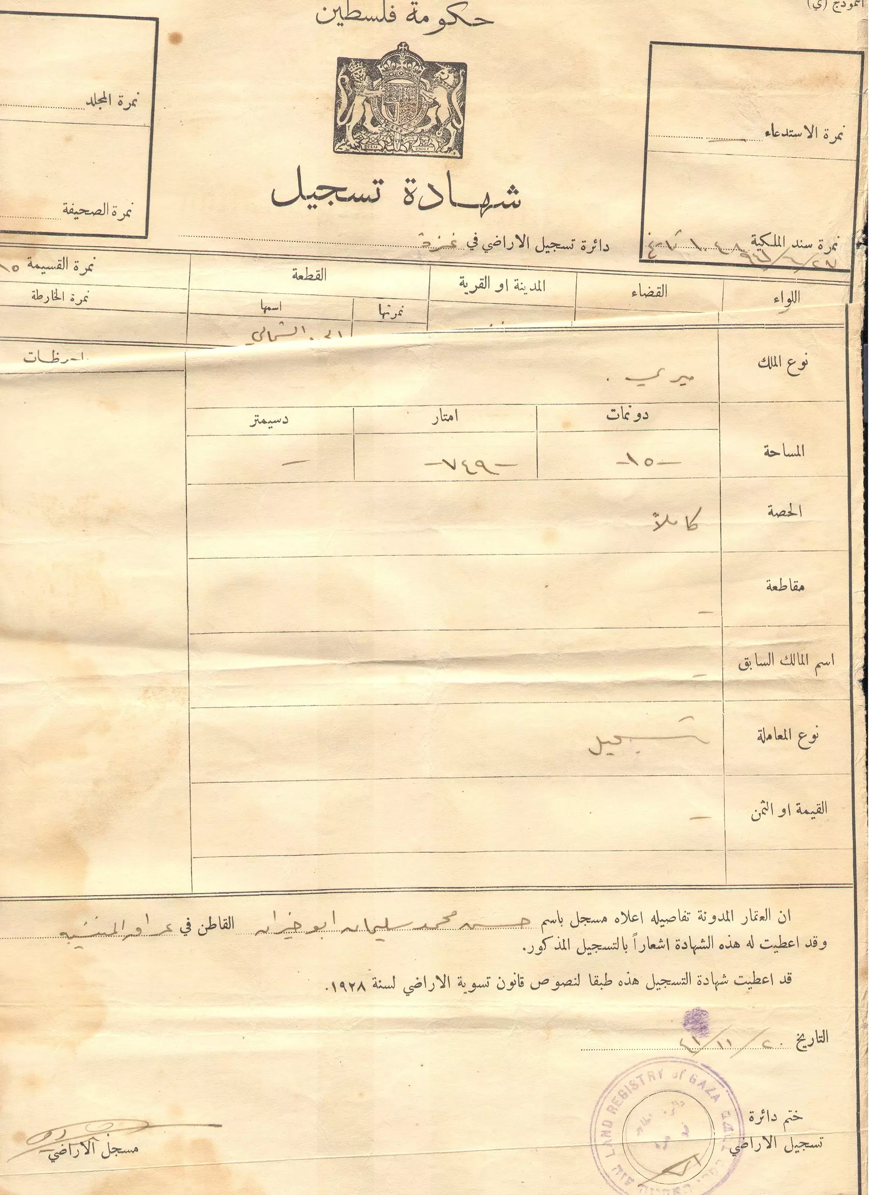
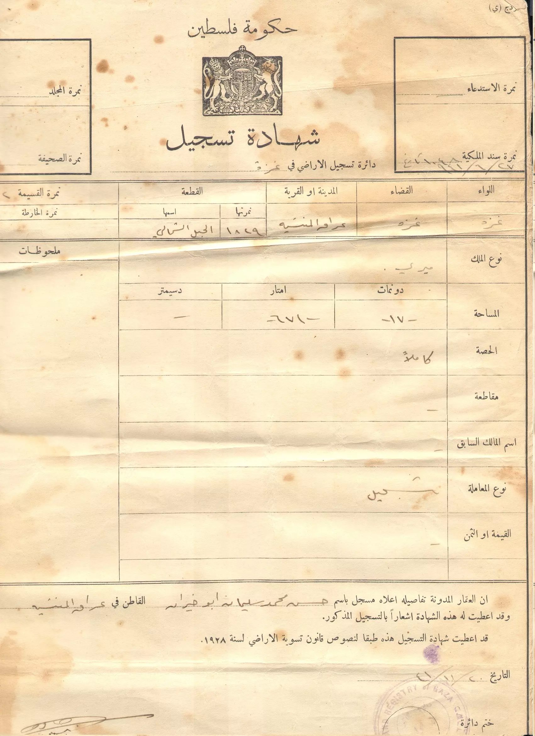
- كوشان ارض (ورقة الطابو) تبثبت ملكية الارض في عراق المنشية لحسن محمد سليمان ابو خيران
- كوشان ارض (ورقة الطابو) تبثبت ملكية الارض في عراق المنشية لحسن محمد سليمان ابو خيران
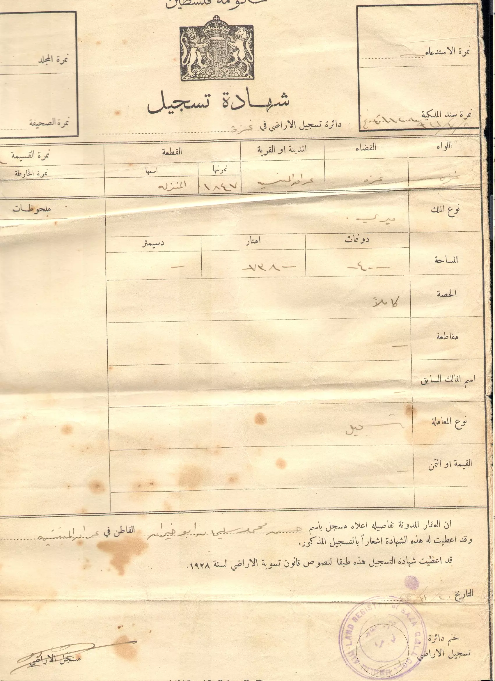
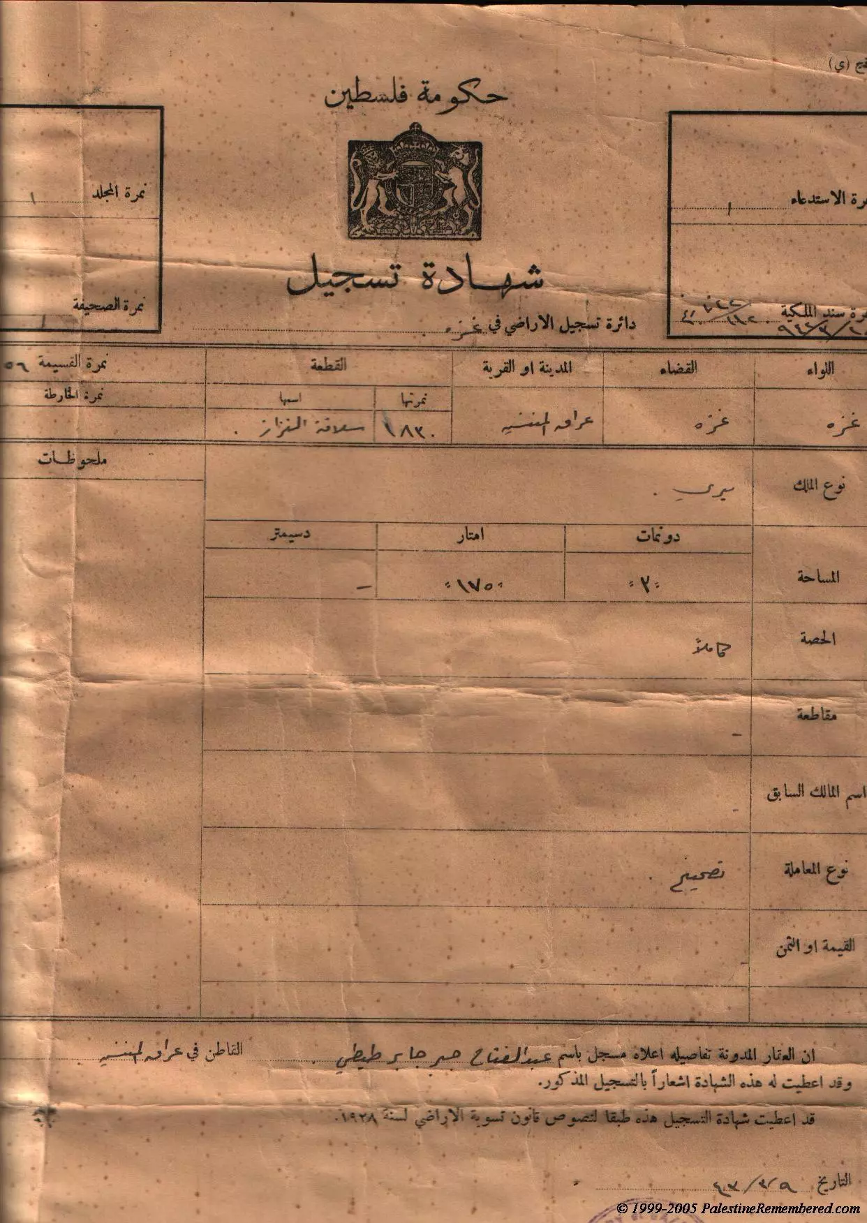
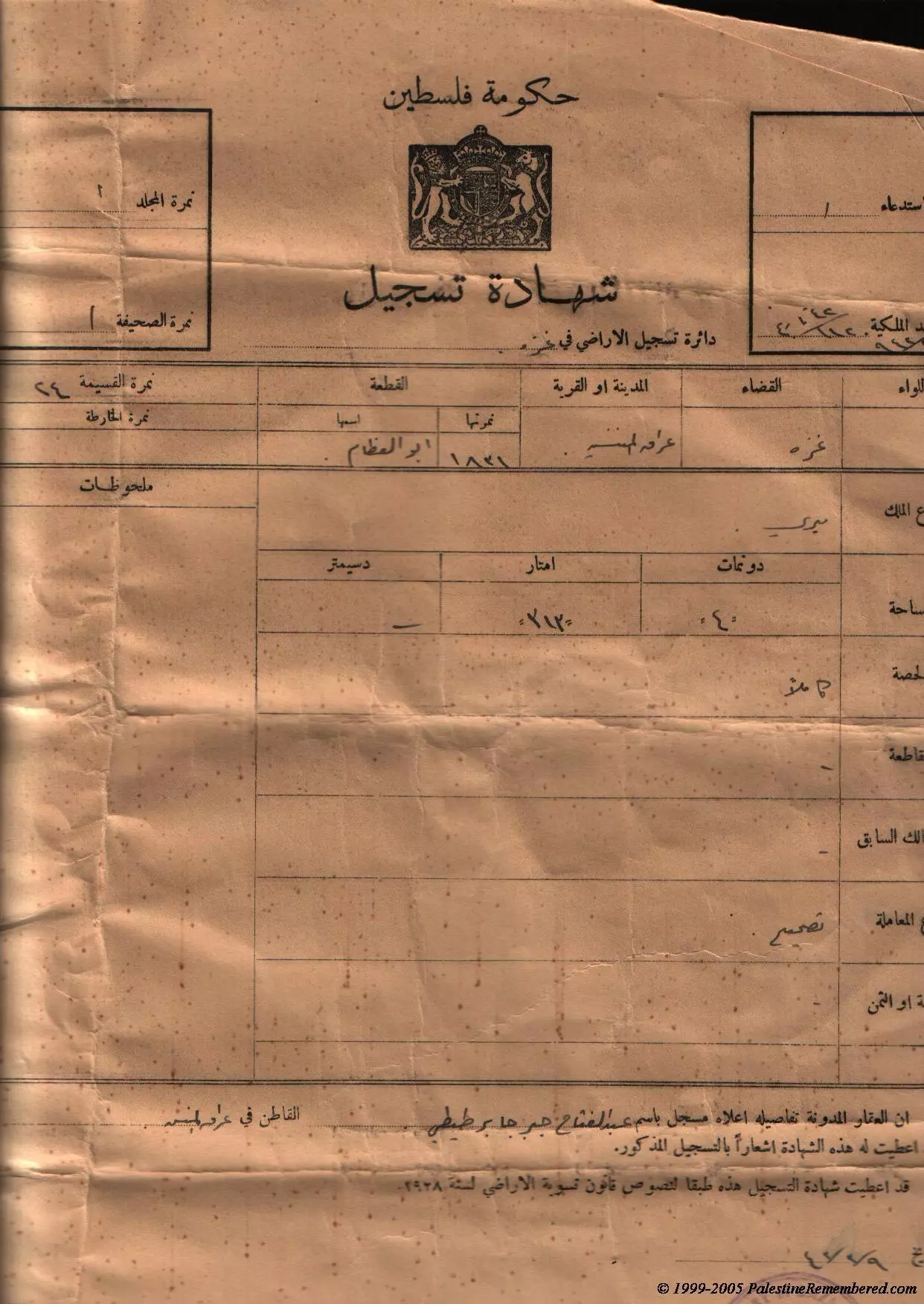
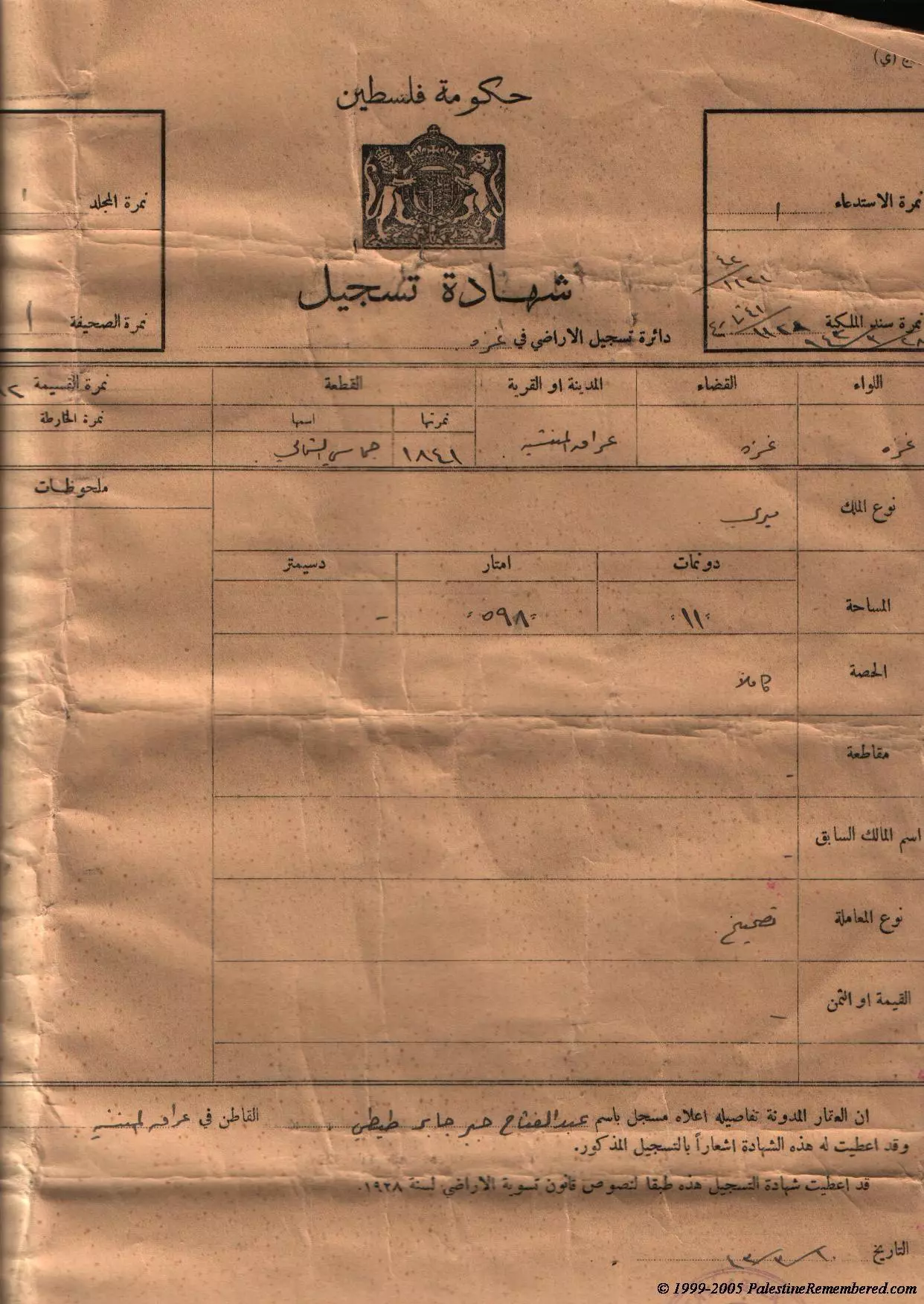
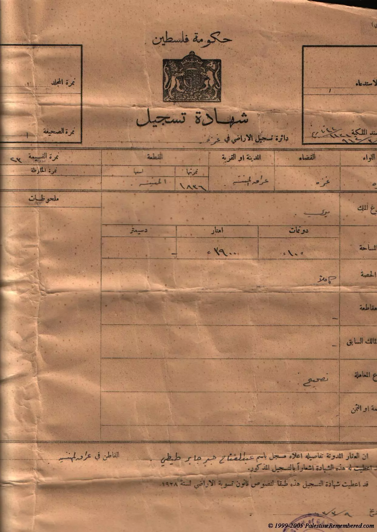
- شهادة تسجيل اراضي صادرة عن حكومة فلسطين في قرية عراق المنشية قضاء غزة
- شهادة تسجيل اراضي صادرة عن حكومة فلسطين في قرية عراق المنشية قضاء غزة
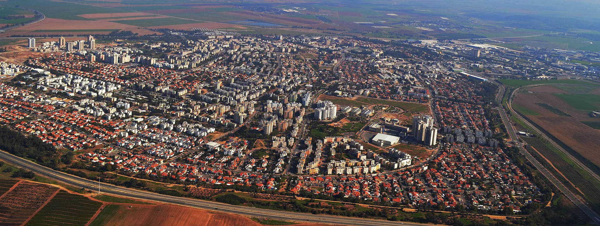
- عراق المنشية منظر شامل من الاعلى للقرية المسروقة من قبل العصابات الصهيونية والتي اسموها كريات جات
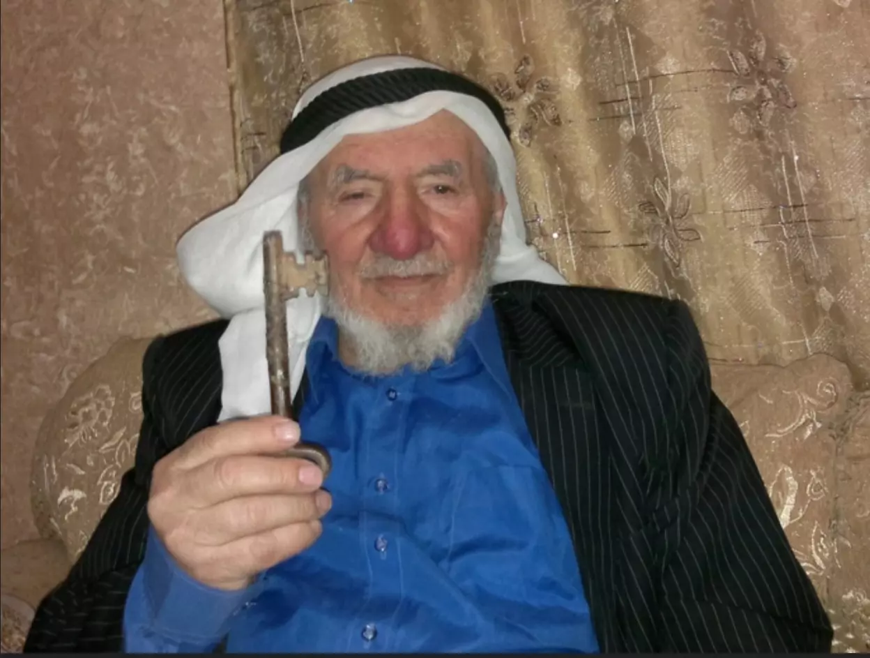
- الحاج حسن الجوابرة (أبو خالد) ( السابعة والسبعين من العمر) قرر تسليم ما لديه من عهدة ومقتنيات لأولاده وأحفاده الذين يزيد عددهم على السبعين، في إشارة إلى تمسكه بحق العودة ورفض الاستسلام للواقع أو نسيان الوطن. المزيد في قسم التعليقات تحت الصور

- الحاج حسن الجوابرة (أبو خالد) ( السابعة والسبعين من العمر) قرر تسليم ما لديه من عهدة ومقتنيات لأولاده وأحفاده الذين يزيد عددهم على السبعين، في إشارة إلى تمسكه بحق العودة ورفض الاستسلام للواقع أو نسيان الوطن #2
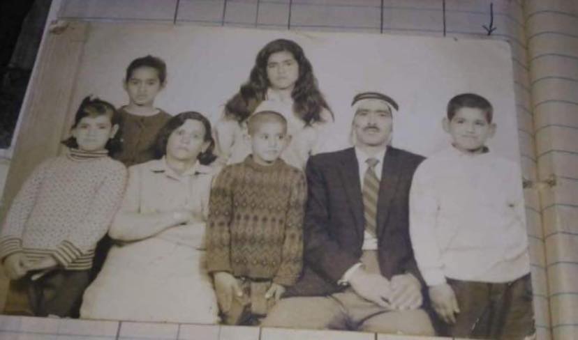
- صورة من سبعينيات القرن الماضي لعائلة محيسن قرية عراق المنشية
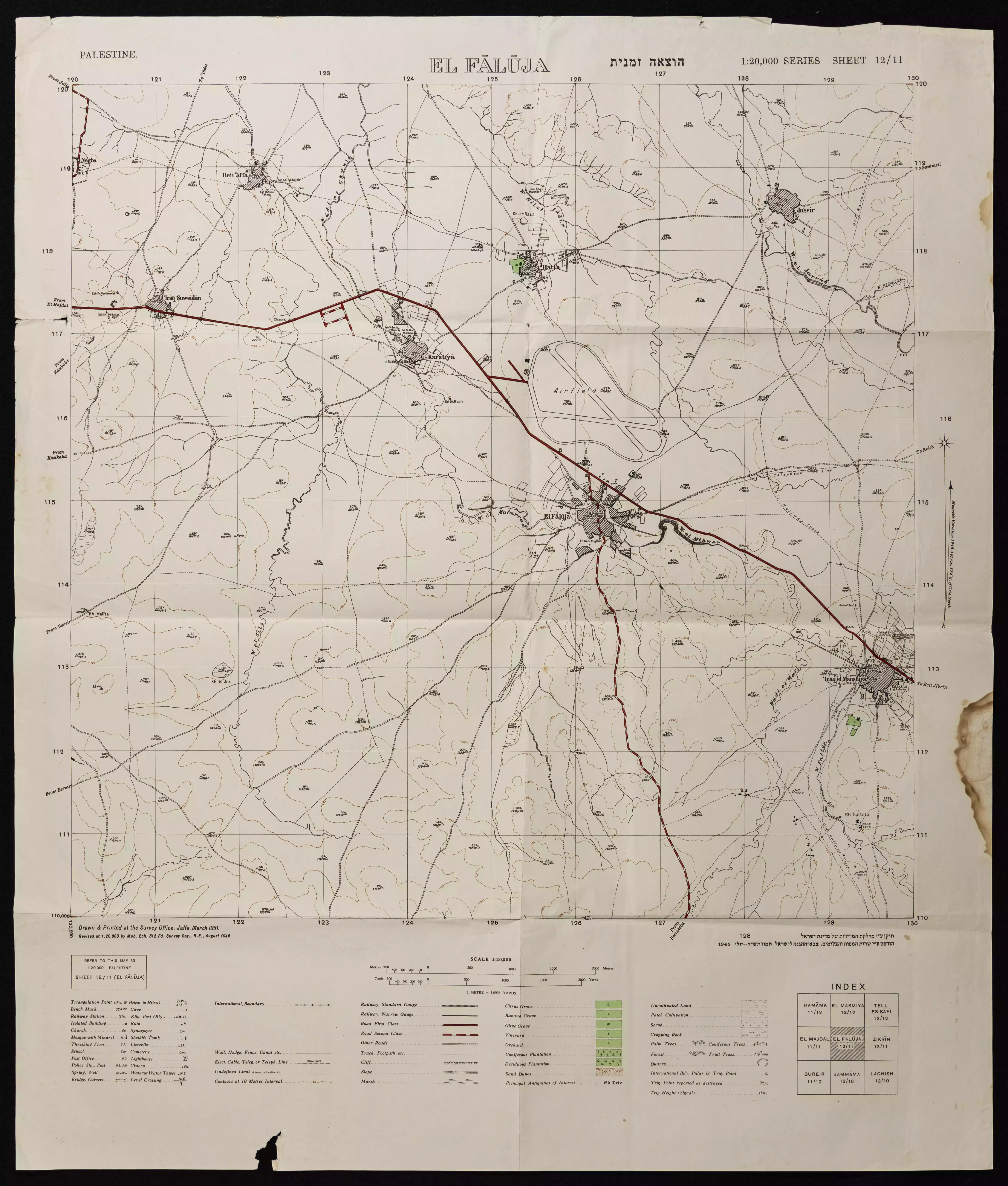
- خارطة تُظهِر الحدود والطرق بأنواعها والأماكن المقدسة والطبيعة الطوبغرافية من تلال وسهول ومنحدرات والتشكيلة الطبيعية للأرض وأنواع المزروعات. نُشرت الخريطة فترة الانتداب البريطاني، تم إضافة تعديلات عليها من قِبَل خدمة الخرائط والصور التابعة للقوات العسكرية الاسرائيلية فترة الأربعينيات.
Want to browse more? 80,000 pictures were grouped in these gallaries:
- كواشين ارض وفرت لنا غضون مقابلة عبدالقادر الطيطي لتدوين شهادته عن النكبة #8
- كواشين ارض وفرت لنا غضون مقابلة عبدالقادر الطيطي لتدوين شهادته عن النكبة #7
- كواشين ارض وفرت لنا غضون مقابلة عبدالقادر الطيطي لتدوين شهادته عن النكبة #6
- كواشين ارض وفرت لنا غضون مقابلة عبدالقادر الطيطي لتدوين شهادته عن النكبة #5
- كواشين ارض وفرت لنا غضون مقابلة عبدالقادر الطيطي لتدوين شهادته عن النكبة #4
- كواشين ارض وفرت لنا غضون مقابلة عبدالقادر الطيطي لتدوين شهادته عن النكبة #3
- كواشين ارض وفرت لنا غضون مقابلة عبدالقادر الطيطي لتدوين شهادته عن النكبة #2
- كواشين ارض وفرت لنا غضون مقابلة عبدالقادر الطيطي لتدوين شهادته عن النكبة
- كوشان ارض (ورقة الطابو) تبثبت ملكية الارض في عراق المنشية لحسن محمد سليمان ابو خيران
- طابو ارض قديم لاراضي قرية عراق المنشية من فترة الدولة العثمانية.
- سند خاقاني : وثائق طابو من الفتر ةالعثمانية عن اراضي قرية عراق المنشية قضاء غزة.
- كوشان ارض (ورقة الطابو) تبثبت ملكية الارض في عراق المنشية لحسن محمد سليمان ابو خيران
- كوشان ارض (ورقة الطابو) تبثبت ملكية الارض في عراق المنشية لحسن محمد سليمان ابو خيران
- شهادة تسجيل اراضي صادرة عن حكومة فلسطين في قرية عراق المنشية قضاء غزة
- شهادة تسجيل اراضي صادرة عن حكومة فلسطين في قرية عراق المنشية قضاء غزة
- الحاج حسن الجوابرة (أبو خالد) ( السابعة والسبعين من العمر) قرر تسليم ما لديه من عهدة ومقتنيات لأولاده وأحفاده الذين يزيد عددهم على السبعين، في إشارة إلى تمسكه بحق العودة ورفض الاستسلام للواقع أو نسيان الوطن. المزيد في قسم التعليقات تحت الصور
| Display Name | Clan/Hamolah | Country of Residence |
| Muheisen | Muheisen | - |
| osamah | - | - |
| ابو حفص الجوابرة | الجوابرة | - |
| عبد الفتاح ابوخيران | ابوخيران | فلسطين, مخيم العروب |
| مكسيموس الجابري | الجوابرة | - |
| ابوعمار | ابوسل | عمان, عراق المنشية |
| ابن العطار | - | اربد |
| ابوعلاء | ابوسل | الرصيفة |
| lubna | - | JORDAN |
| الوحش | - | - |
| انس صلاح | - | الرصيفة |
| heba abu sal | abu sal | zarqa-hitten camp, jordan |
| نغم الحياة الفضيلات | الجوابره | الاردن |
| ahea | - | - |
| معاذ الجابري | الجابري | - |
| محمد الجابري | الجابري | Amman, Jordan |
| د. عواد الطيطي | الطيطي | - |
| حنظلة | الطيطي | اربد |
| مراد عطاالله عبدالرحمن عطيه ابوسل | أبوسل | - |
| "طـــــKHAIRـــير الغربـــــABU YEHYAـــة" | الجابري | عين الباشا-البقعة |
| علاء ابو خيران | AL_JAWABREH | PALESTINE |
| محمد ابوازغريت | الجوابره | الرياض |
| هيثم يوسف حسين الفضيلات | - | عمان |
| عبد العزيز الطيطي | - | الاردن, اربد |
| عراقاوي | ابو داود | JORDAN, JORDAN |
| اياد الطيطي | الطيطي | مخيم حطين, مخيم حطين |
| ikmadi | الجوابرة | الجبيهة, الاردن |
| yousef khalil aqeel shafout | شعفوط | - |
| علي الجوابرة | JAWABREH | DUBAI |
| حسام أبوخيران | الجوابرة | عمان, الأردن |
| الدكتور حاتم الطيطي | الطيطي | جرش, الاردن |
| قصي ابوسل | ابوسل | - |
| musab titi | Altiti | Montana, U.S.A |
| قاهر الأحزان أبو وردة | أبو وردة | - |
| يوسف طلب | الطيطي | الأردن, 211110 P.O BOX 4399 |
| khaldoon Al-Jabri | AL-JABRI | - |
| عرقاوي | أبوسل | - |
| KHALID JAMIL AL-JABRY | AL-JABRY | ABU DHABI, UAE |
| د. محمد الطيطي | - | - |
| جلال الجابري | الجابري | Abu Dhabi, UAE |
| jamil altiti | altiti | zarqa-jordan, jordan |
| زياد عناز محمد طيطي | طيطي | الخليل |
| fadi altiti | altiti | amman, jordan |
| عادل عيسى يونس | طيطي | البلقاء |
| saed_titi | - | - |
| هشام صلاح | - | jordan |
| ابو سل | - | - |
| محمد الطيطي | - | - |
| الحرية | طيطي | - |
| titi2007 | titi | الخليل, الفوار |
| zuhair titi | titi | jordan alzarqa |
| ismail Jawabreh | Jawabreh | ajman, U.A.E |
| ahmad jawabreh | jawabreh | amman, jordan |
| Khaled Ahmed Ali | Ayesh | Amman, Jordan |
| wisam ali amer al titi | Al Titi | irbid, jordan |
| HASSAN | ALJABIRY | - |
| abdullah aljaberi | aljaberi | - |
| jafar | Al-Titi | - |
| tareq albadawi | badawi | - |
| Khaled Al Titi | Al Titi | - |
| altiti | altiti | irbed, jordan |
| Ahmad | al-jaberi | NY, USA |
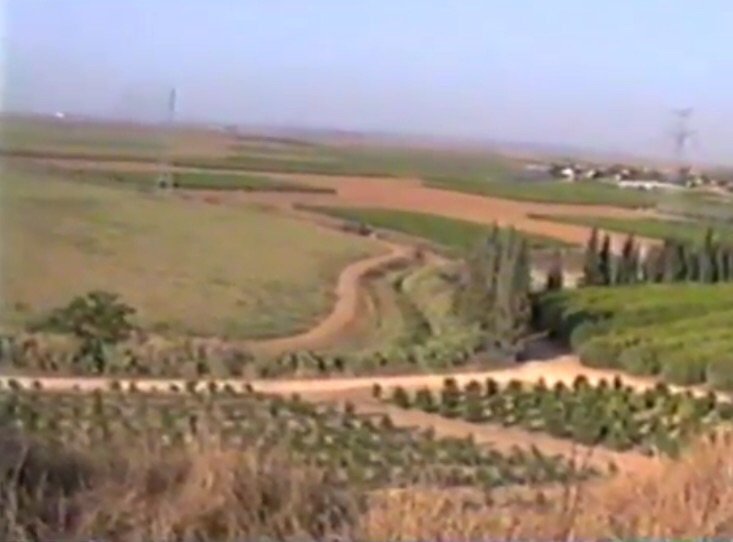
- Tracing all that remains fo Iraq al-Manshiyya since Nakba
- فيلم مصور عن عراق المنشيه تم تصويره عام 1998 من قبل عبد الرحمن الجابري ومختص بجغرافية القريه Duration: 9 min
- فيلم مصور عن عراق المنشية تم تصويره عام 1998 من قبل عبد الرحمن الجابري ومختص بجغرافية القرية - 2 Duration: 8 min 59 sec
- فيلم مصور عن عراق المنشيه تم تصويره عام 1998 -3
- فيلم مصور عن عراق المنشيه تم تصويره عام 1998 - 4
- سلسلة حكاية قرية من فلسطين| قرية عراق المنشية (5) موسوعة القرى الفلسطينية Duration: 5 min 50 sec
No links have been shared yet, be free to the first to share the first link.
 Fake Valor: Why Did Zionist Jews Hoist Nazis Flag on Their Ships in the 1930s?
What is new?
-
Facts About Oct. 7th Gaza Raid
-
Remined Us Please:: Who Did Rape Who? Palestinians Raped Israelis? Or, was the other way around?
-
When Prof. Edward Said was invited to debate Bibi Netanyahu in the 1980s, watch what happened!
-
Ezra Klein of the NY Times on the "Jewish Race".
-
Abusing Blood Libel!
-
Did Israeli Soldiers Activate The Hanniba Direective On Oct. 7th? You Be The Judge
-
Zionist FAQ: Isn't it true that Palestinians don't want peace? Palestinians never accepted the two-state solution
- Facts about Haavara (Transfer) Agreement between Ben-Gurion & Hitler
-
Haavara FAQs: Why Did Zionist Jews Hoist Nazis' Flags on Their Ships in the 1930s?
- Haavara FAQs: When Chaim Weizmann met FDR in mid-1943, why was he silent about rescuing European Jewry?
-
Dear ChatGPT: How did Palestinians resist Napoleon's invasion of their country in 1799?
-
Dear ChatGPT: Gaza had a vibrant Jewish community in the mid-17th century. What happened to them?
-
Dear ChatGPT: Why did the Jewish Agency suppress news of the Holocaust during WWII?
-
Video Playlist: Jews share their DNA tests to end the conflict for good.
-
A Tale of Two Conflicts: Examining the Definition of Genocide
-
Prof. Abraham Polak And The Suppressed History of the Khazars and European Jewry
-
How Ronald Reagan would have framed the genocide in Gaza if he were still alive?
-
Haavara FAQs: Let us do the math: how many German Jews did The Haavara Agreement save?
-
Zionist FAQs: The Hebron Massacre of 1929, "clearly proves" that Palestinians are antisemitic, how could you deny it?
-
Zionist FAQs: Why Anti-Zionist Is Not Antisemitism?
-
Zionist FAQs: Isn't it true that the KGB created Palestinian Nationalism in the early 1960s?
- Zionist FAQs: Muslims are killing Muslims all the time; why are Israeli Jews being singled out in the media?
- Zionist FAQs: How is Israel an apartheid state when 20% of its citizens are Arabs who enjoy full rights?
-
Haavara FAQs: Why Did Dorothy Thompson Flip From A Zionist Advocate to A Silenced Dissenter?
-
Haavara FAQs: Analysis of Herzl's Uganda Scheme and how it could have saved millions of Jews.
-
Haavara FAQs: Why did Hayim Greenberg describe American Jewry as "morally bankrupt" in early 1943?
-
Haavara FAQs: What if the Evian Conference was a resounding success? What would have been the impact of saving European Jewry on Zionism?
- Haavara FAQs: What if the six million were saved, how that would have impacted the Zionist project?
-
Haavara FAQs: How did Zionist leaders react when Europe's Jews lingered in the DP camps after WWII ended?
-
Why does the American Jewish community repeat lies that David Ben-Gurion had debunked before he died?
-
Who has the power to rename the Tatar/Khazar Gene Marker to Jewish IV?
-
Zionist FAQs: Why won't Egypt, Syria, and Jordan take their people back? Jews are indigenous to Palestine, and Arabs immigrated after Jews developed the country. Arabs should leave.
-
Haavara FAQs: Did Hitler and the Nazis conflate between Judaism and Zionist? If that wasn't case, then why?
-
Haavara FAQs: Winston Churchill and antisemitism, a collection of articles written Churchill.
-
Haavara FAQs: Broken by country, how many Jews survived vs. killed during the Holocaust?
-
Haavara FAQs: Why did European Jews vote with their feet and to immigrated to the Americas, not Palestine, after WWII?
-
Watch this American Jewish Girl describing Israeli Jews' cognitive dissonance like no other in under two minutes
-
Haavara FAQs: When the Nazis went out of their way to hide the Holocaust, Israeli Jews did the exact opposite by broadcasting their genocide of Gazans. But why?
-
Haavara FAQs: How Zionist Jews went out of their to show their appreciation to Nazism and Fascism?
- Haavara FAQs: Why Zionist leaders were against bombing the death camps & the Railroads leading to them?
-
Haavara FAQs: Hitler's message to the British and American people: If Jews are such noble citizens and you care about them, how come you're not letting them in? I will gladly ship them to you at my expense, even on luxury liners!
-
A shortlist of Zionist and Israeli false flag operations in the name Jews.
-
The Most Moral Army
- The Land of Kapos (Israel): Where the brave are boycotted and Kapos walk free.
- Why did early Zionists often named their communal enterprises "colonial"?
- Zionist Relations with Nazi Germany by Faris Glubb
-
Two NY Times advertisements by Zionists in the early 1943 that exposes Zionists' treason at the height of the calamity
- Facts Not Lies about the Palestinian-Israeli Conflict.
- Site's pictures have been categorized
- Campgain Against Lice
- A Survey of Palestine, the official source about Palestine before Nakba produced by the British Mandate; over 1200 pages.
- Satellite View & Google Earth: Over 6,000 placemarks identifying all destroyed towns, W. Bank & Gaza Strip Towns, & refugee camps.
- PalestineRemembered.com and its Nakba Oral History Project were featured on al-Jazeera Satellite TV.
- Nakba Oral History Video Podcast:
 Over 700 Oral History interviews (including 3,500+ hours of recording) can be viewed online.
 - Palestine Village Statistics Project
- Gaza Jail Break
- النسخة العربية للموقع الان متوفرة
- Videos: Documenting the destroyed villages in video: Tracing all that remains since Nakba.
- Videos: Responding to Zionist Propaganda
- Interview: The ethnic cleansing of Palestine: George Galloway interviews Israeli Historian Ilan Pappe.
- For Palestinians, memory matters. It provides a blueprint for their future By George Bisharat.
- Zionist FAQ now available in Hebrew שאלות שציונים שואלים, עכשיו בעברית
- Video: The Stephen Walt and John Mearsheimer report on the influence of the Israel Lobby on U.S. Foreign Policy
- The Palestinian-Israeli conflict for beginners
