| PalestineRemembered | About Us | Oral History | العربية | |
| Pictures | Zionist FAQs | Haavara | Maps | |
| Search |
| Camps |
| Districts |
| Acre |
| Baysan |
| Beersheba |
| Bethlehem |
| Gaza |
| Haifa |
| Hebron |
| Jaffa |
| Jericho |
| Jerusalem |
| Jinin |
| Nablus |
| Nazareth |
| Ramallah |
| al-Ramla |
| Safad |
| Tiberias |
| Tulkarm |
| Donate |
| Contact |
| Profile |
| Videos |
Welcome To al-Jaladiyya - الجلدية (אל-ג'לדיה)
|
District of Gaza
Ethnically cleansed days ago |
العربية Google Earth |
 |
Gallery (2) |
- Statistics & Facts
-
Before & After

- Satellite View
- Articles 1
- Pictures 2
- Oral History 2
- Members 13
- All That Remains
- Wikipedia
- Videos
- Guest Book 2
- Links 2
| Statistic & Fact | Value | ||||||||||||||
| Occupation Date | July 8, 1948 | ||||||||||||||
| Distance From District | 34 (km) North East of Gaza | ||||||||||||||
| Elevation | 75 (meters) | ||||||||||||||
| Before & After Nakba, Click Map For Details |
|||||||||||||||
|
|||||||||||||||
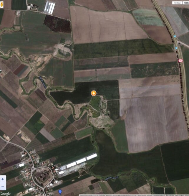
| Map Location | See location #16 on the map View from satellite |
||||||||||||||
| Attacking Units | Giv'ati Brigade | ||||||||||||||
| Exodus Cause | Expulsion by Zionist troops | ||||||||||||||
| Village Temains | The village was completely defaced. | ||||||||||||||
| Ethnically Cleansing | al-Jaladiyya inhabitants were completely ethnically cleansed. | ||||||||||||||
| Pre-Nakba Land Ownership |
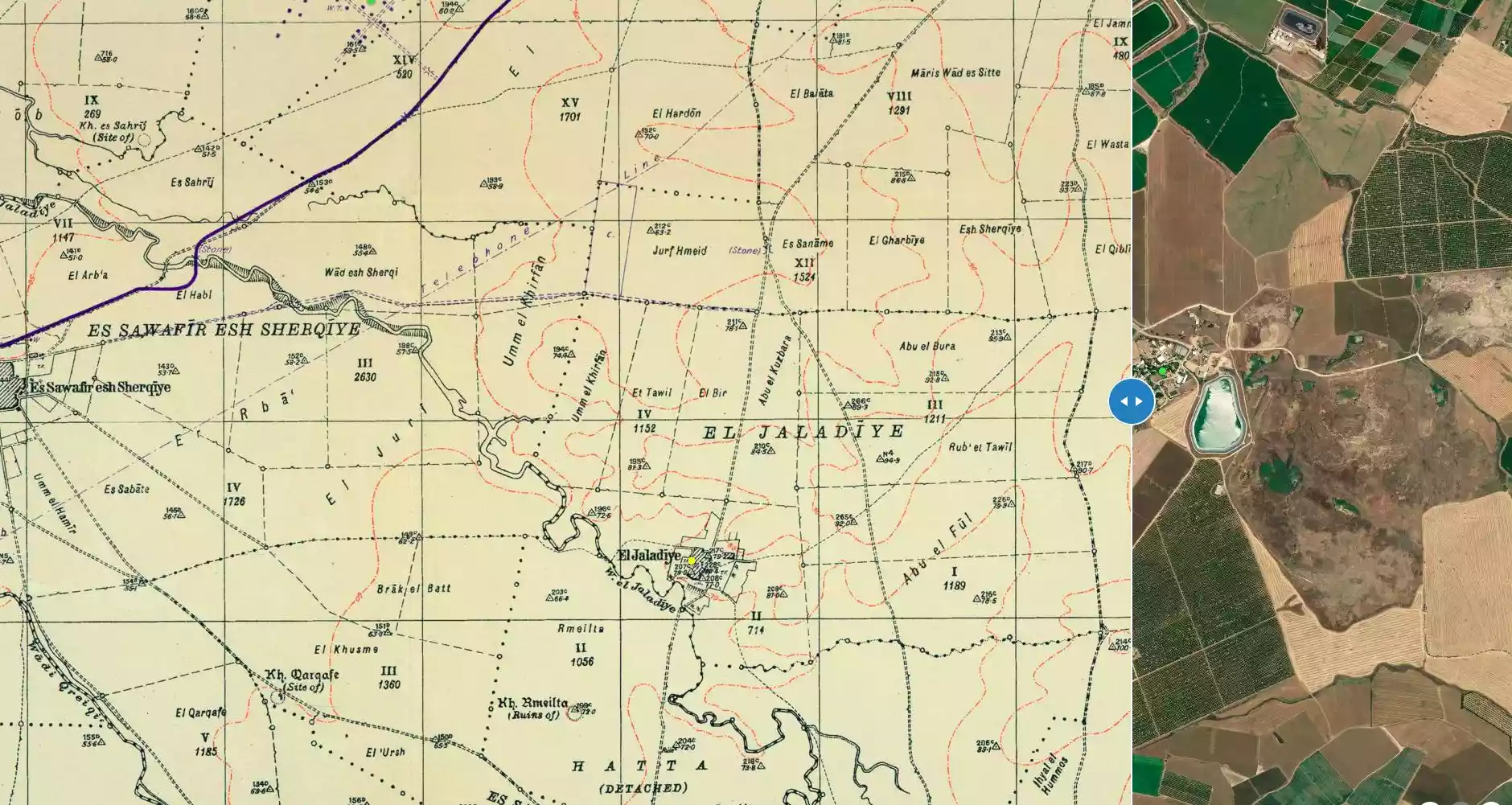
**Town Lands' Demarcation Maps |
||||||||||||||
| Land Usage As of 1945 |
|
||||||||||||||
| Population |
|
||||||||||||||
| Number of Houses |
|
||||||||||||||
| Near By Towns |
|||||||||||||||
|
|||||||||||||||
| Town's Name Through History | The Crusades built in the village a castle known by Geladia with which al-Jaladiyya was identified. | ||||||||||||||
| Schools | al-Jaladiyya had a school located in its Mosque, and when it opened its doors in 1945 it had an enrollment of 43 students. | ||||||||||||||
| Places of Warship | The village had one mosque constructed in 1890. | ||||||||||||||
| Exculsive Jewish Colonies Who Usurped Village Lands |
No settlements on village lands | ||||||||||||||
| Featured Video | |||||||||||||||
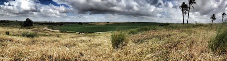
Village Before NakbaThe village stood on a slightly elevated spot on the southern coastal plain, bordered on the southeast side by Wadi Suqrir. Secondary roads linked it to al-Faluja, in the south, to the highway leading to the town of al-Majdal, in the southwest, and to a number of the area's villages. The village may have been located on the site where the Crusaders had built the castle of Geladia. The scholars who participated in the late nineteenth century British survey and current Crusader scholars seem convinced that Geladia was built on the site of Khirbat Jaladiyya; they point to the fragments of architecture ('one block of a tower') as evidence of this. In 1596, al-Jaladiyya was a village in the nahiya of Gaza (liwa' of Gaza), with a population of eighty-eight. It paid taxes on a number of crops, including wheat, barley, and sesame, as well as on other types of produce and property, such as goats, beehives, and vineyards. It seems that the site may have been abandoned during the seventeenth century, however , and may not have been re-inhabited until the 1870s.Al-Jaladiyya's inhabitants, all of whom were Muslim, built their houses of adobe and maintained a mosque in the village that was constructed in 1890 on the order of the Ottoman sultan Abd al-Hamid II (1876–1909). The mosque had two sections, one for prayer and another for teaching, and 43 students were enrolled in the mosque school by the mid-1940s. Rainfed agriculture was the basis of the economy. In 1944/45 a total of 4,185 dunums was allotted to cereals. Village Occupation and Ethnic CleaningBetween the two truces of the war (8–18 July 1948, a period also known as the 'Ten Days'), the Israeli army launched an offensive on the southern front to extend its area of control southwards towards the Negev. In the process, over sixteen villages were occupied in the area between the coast and the Hebron foothills, driving at least 20,000 people from their homes, according to figures cited by Israeli historian Benny Morris. Al-Jaladiyya was probably occupied in the first stage of the operation, on 9–10 July, by units of the Giv'ati Brigade. Its inhabitants either fled eastwards in the direction of Hebron, like most of the refugees from the area seized during the operation, or southwards to the Gaza Strip. Although Giv'ati sources later recalled that the people fled before the entry of the columns into their villages, the Brigade's operational orders had demanded that civilians be expelled. A New York Times article speculated that the occupation of this and a few other villages on the al-Majdal–al-Latrun road prevented Egyptian forces from attempting to break through to al-Latrun.Zionists Colonies on Village LandsThere are no Israeli settlements on village lands. Shafir, established in 1949, is to the southeast of the site, and Zerachya, established in 1950, is to the southwest of the site. Both are on the land of al-Sawafir al-Sharqiyya Morris states that these two settlements were considered for placement on the lands of al-Jaladiyya, according to a plan submitted by the Jewish National Fund on 20 August 1948.Village TodayOnly a few date-palm, carob, and fig trees remain on the site. The surrounding lands are cultivated by Israeli farmers.SourceDr. Walid al-Khalidi, 1992: All That Remains. |
|||||||||||||||
| Related Maps | Town Lands' Demarcation Maps خرائط للقضاء توضح حدود القرى والاودية Town's map on MapQuest View from satellite Help us map this town at WikiMapia |
||||||||||||||
| Related Links | Wikipedia's Page Google Search Google For Images Google For Videos |
||||||||||||||
| More Information | في كتاب كي لا ننسى في كتاب بلادنا فلسطين المزيد من موقع هوية |
||||||||||||||
Want to browse more? 80,000 pictures were grouped in these gallaries:
| Display Name | Clan/Hamolah | Country of Residence |
| علي امجد خضر | - | - |
| محمد فتحي خضر | - | - |
| محمد أبو السعود | - | GAZA |
| Dr-Abdalfatah Khader | - | - |
| Mohamed Khedr | Khedr | Alexandria, Egypt |
| محمود السعدوني | السعدوني | - |
| امينة خضر | خضر | الاردن, الاردن |
| abdelhadi.z.khader | khader | khanyonis |
| Abu Dana | Yousef | Dammam, السعوديه |
| الشخريت | الشخريت | AMAAN, AMAAN |
| Dr. Mohammed Khader | Khader | Amman, Jordan |
| kalloub | aljaladia | - |
| Naser Kalloub | al-Jaladiyya | Rafah |
 Fake Valor: Why Did Zionist Jews Hoist Nazis Flag on Their Ships in the 1930s?
What is new?
-
Facts About Oct. 7th Gaza Raid
-
Remined Us Please:: Who Did Rape Who? Palestinians Raped Israelis? Or, was the other way around?
-
When Prof. Edward Said was invited to debate Bibi Netanyahu in the 1980s, watch what happened!
-
Ezra Klein of the NY Times on the "Jewish Race".
-
Abusing Blood Libel!
-
Did Israeli Soldiers Activate The Hanniba Direective On Oct. 7th? You Be The Judge
-
Zionist FAQ: Isn't it true that Palestinians don't want peace? Palestinians never accepted the two-state solution
- Facts about Haavara (Transfer) Agreement between Ben-Gurion & Hitler
-
Haavara FAQs: Why Did Zionist Jews Hoist Nazis' Flags on Their Ships in the 1930s?
- Haavara FAQs: When Chaim Weizmann met FDR in mid-1943, why was he silent about rescuing European Jewry?
-
Dear ChatGPT: How did Palestinians resist Napoleon's invasion of their country in 1799?
-
Dear ChatGPT: Gaza had a vibrant Jewish community in the mid-17th century. What happened to them?
-
Dear ChatGPT: Why did the Jewish Agency suppress news of the Holocaust during WWII?
-
Video Playlist: Jews share their DNA tests to end the conflict for good.
-
A Tale of Two Conflicts: Examining the Definition of Genocide
-
Prof. Abraham Polak And The Suppressed History of the Khazars and European Jewry
-
How Ronald Reagan would have framed the genocide in Gaza if he were still alive?
-
Haavara FAQs: Let us do the math: how many German Jews did The Haavara Agreement save?
-
Zionist FAQs: The Hebron Massacre of 1929, "clearly proves" that Palestinians are antisemitic, how could you deny it?
-
Zionist FAQs: Why Anti-Zionist Is Not Antisemitism?
-
Zionist FAQs: Isn't it true that the KGB created Palestinian Nationalism in the early 1960s?
- Zionist FAQs: Muslims are killing Muslims all the time; why are Israeli Jews being singled out in the media?
- Zionist FAQs: How is Israel an apartheid state when 20% of its citizens are Arabs who enjoy full rights?
-
Haavara FAQs: Why Did Dorothy Thompson Flip From A Zionist Advocate to A Silenced Dissenter?
-
Haavara FAQs: Analysis of Herzl's Uganda Scheme and how it could have saved millions of Jews.
-
Haavara FAQs: Why did Hayim Greenberg describe American Jewry as "morally bankrupt" in early 1943?
-
Haavara FAQs: What if the Evian Conference was a resounding success? What would have been the impact of saving European Jewry on Zionism?
- Haavara FAQs: What if the six million were saved, how that would have impacted the Zionist project?
-
Haavara FAQs: How did Zionist leaders react when Europe's Jews lingered in the DP camps after WWII ended?
-
Why does the American Jewish community repeat lies that David Ben-Gurion had debunked before he died?
-
Who has the power to rename the Tatar/Khazar Gene Marker to Jewish IV?
-
Zionist FAQs: Why won't Egypt, Syria, and Jordan take their people back? Jews are indigenous to Palestine, and Arabs immigrated after Jews developed the country. Arabs should leave.
-
Haavara FAQs: Did Hitler and the Nazis conflate between Judaism and Zionist? If that wasn't case, then why?
-
Haavara FAQs: Winston Churchill and antisemitism, a collection of articles written Churchill.
-
Haavara FAQs: Broken by country, how many Jews survived vs. killed during the Holocaust?
-
Haavara FAQs: Why did European Jews vote with their feet and to immigrated to the Americas, not Palestine, after WWII?
-
Watch this American Jewish Girl describing Israeli Jews' cognitive dissonance like no other in under two minutes
-
Haavara FAQs: When the Nazis went out of their way to hide the Holocaust, Israeli Jews did the exact opposite by broadcasting their genocide of Gazans. But why?
-
Haavara FAQs: How Zionist Jews went out of their to show their appreciation to Nazism and Fascism?
- Haavara FAQs: Why Zionist leaders were against bombing the death camps & the Railroads leading to them?
-
Haavara FAQs: Hitler's message to the British and American people: If Jews are such noble citizens and you care about them, how come you're not letting them in? I will gladly ship them to you at my expense, even on luxury liners!
-
A shortlist of Zionist and Israeli false flag operations in the name Jews.
-
The Most Moral Army
- The Land of Kapos (Israel): Where the brave are boycotted and Kapos walk free.
- Why did early Zionists often named their communal enterprises "colonial"?
- Zionist Relations with Nazi Germany by Faris Glubb
-
Two NY Times advertisements by Zionists in the early 1943 that exposes Zionists' treason at the height of the calamity
- Facts Not Lies about the Palestinian-Israeli Conflict.
- Site's pictures have been categorized
- Campgain Against Lice
- A Survey of Palestine, the official source about Palestine before Nakba produced by the British Mandate; over 1200 pages.
- Satellite View & Google Earth: Over 6,000 placemarks identifying all destroyed towns, W. Bank & Gaza Strip Towns, & refugee camps.
- PalestineRemembered.com and its Nakba Oral History Project were featured on al-Jazeera Satellite TV.
- Nakba Oral History Video Podcast:
 Over 700 Oral History interviews (including 3,500+ hours of recording) can be viewed online.
 - Palestine Village Statistics Project
- Gaza Jail Break
- النسخة العربية للموقع الان متوفرة
- Videos: Documenting the destroyed villages in video: Tracing all that remains since Nakba.
- Videos: Responding to Zionist Propaganda
- Interview: The ethnic cleansing of Palestine: George Galloway interviews Israeli Historian Ilan Pappe.
- For Palestinians, memory matters. It provides a blueprint for their future By George Bisharat.
- Zionist FAQ now available in Hebrew שאלות שציונים שואלים, עכשיו בעברית
- Video: The Stephen Walt and John Mearsheimer report on the influence of the Israel Lobby on U.S. Foreign Policy
- The Palestinian-Israeli conflict for beginners
