| PalestineRemembered | About Us | Oral History | العربية | |
| Pictures | Zionist FAQs | Haavara | Maps | |
| Search |
| Camps |
| Districts |
| Acre |
| Baysan |
| Beersheba |
| Bethlehem |
| Gaza |
| Haifa |
| Hebron |
| Jaffa |
| Jericho |
| Jerusalem |
| Jinin |
| Nablus |
| Nazareth |
| Ramallah |
| al-Ramla |
| Safad |
| Tiberias |
| Tulkarm |
| Donate |
| Contact |
| Profile |
| Videos |
Welcome To al-Sawafir al-Sharqiyya - السوافير الشرقية (א-סואפיר א-שרקיה)
|
District of Gaza
Ethnically cleansed days ago |
العربية Google Earth |
 |
Gallery (9) |
- Statistics & Facts
-
Before & After

- Satellite View
- Articles 1
- Pictures 9
- Land Deeds 5
- Oral History 1
- Members 32
- All That Remains
- Wikipedia
- Videos
- Guest Book 9
- Links 1
| Statistic & Fact | Value | |||||||||||||||||||||
| Occupation Date | May 18, 1948 | |||||||||||||||||||||
| Distance From District | 32 (km) North East of Gaza | |||||||||||||||||||||
| Elevation | 50 (meters) | |||||||||||||||||||||
| Before & After Nakba, Click Map For Details |
||||||||||||||||||||||
|
||||||||||||||||||||||
| Map Location | See location #12 on the map View from satellite |
|||||||||||||||||||||
| Military Operation | Second stage of Operation Barak | |||||||||||||||||||||
| Attacking Units | Possibly Giva'ti Brigade | |||||||||||||||||||||
| Exodus Cause | Fear of Jewish attack, or of being caught in the fighting | |||||||||||||||||||||
| Village Temains | The village has been completely defaced. | |||||||||||||||||||||
| Ethnically Cleansing | al-Sawafir al-Sharqiyya inhabitants were completely ethnically cleansed. | |||||||||||||||||||||
| Pre-Nakba Land Ownership |
**Town Lands' Demarcation Maps |
|||||||||||||||||||||
| Land Usage As of 1945 |
|
|||||||||||||||||||||
| Population |
|
|||||||||||||||||||||
| Number of Houses |
|
|||||||||||||||||||||
| Near By Towns |
||||||||||||||||||||||
|
|
||||||||||||||||||||||
| Schools | The village shared a school with the other two Sawafir villages, and it had an enrollment of about 280 in 1945. | |||||||||||||||||||||
| Places of Warship | One mosque | |||||||||||||||||||||
| Exculsive Jewish Colonies Who Usurped Village Lands |
'En Tzurim, Deganim, Shafir, Zerachya, and Nir Banim. | |||||||||||||||||||||
| Featured Video | ||||||||||||||||||||||
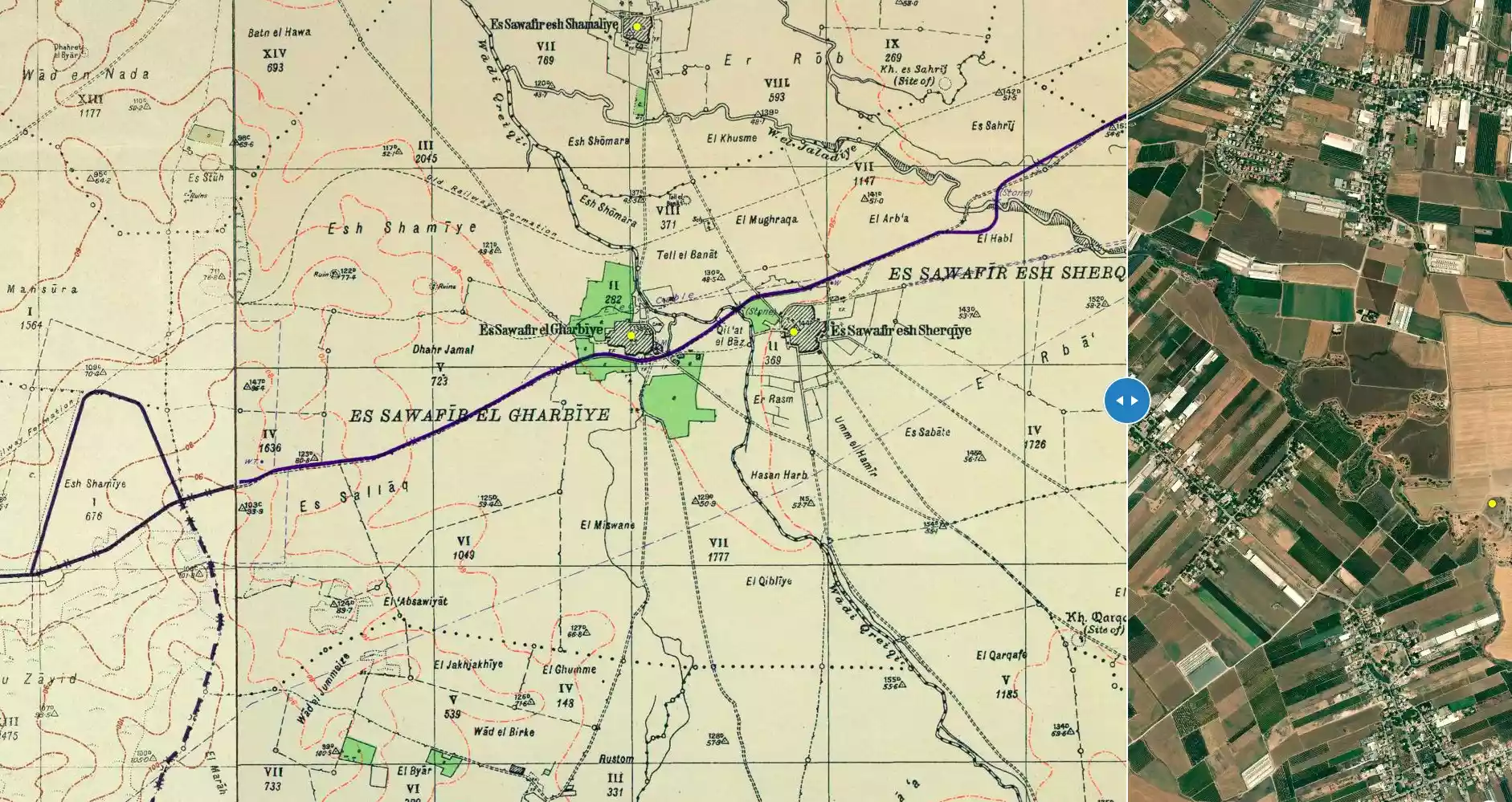
Village Before NakbaThe village was situated on the coastal plain on the east, just south of the highway to al-Majdal and Gaza (to the southwest) and Ramla and Jerusalem (to the northeast). The adjectival al-Sharqiyya ('eastern') distinguished it from the two other neighboring villages with the same first name, al-Sawafir. Together they formed an approximately right-angled triangle, with a northwest-southeast hypotenuse. In 1596, al-Sawafir al-Sharqiyya was a village in the nahiya of Gaza (liwa' of Gaza). It paid taxes on vineyards, as well as on a number of crops, including wheat, barley, fruit, and cotton.In the late nineteenth century, the village of al-Sawafir al-Sharqiyya had several small gardens and wells. The population was Muslim. Village houses were built of adobe, although a few were of stone. The village had a mosque, and the school it shared with the other two villages had an enrollment of about 280 students by the mid-1940s. Agriculture, which was mainly rainfed, constituted the backbone of the economy. Grain, citrus, grapes, and apricots were grown. In 1944/45 a total of 930 dunums was devoted to citrus and bananas and 11,821 dunums were allotted to cereals; 386 dunums were irrigated or used for orchards. Village Occupation and Ethnic CleaningUnits of the Giv'ati Brigade occupied the village during the second stage of Operation Barak, according to two separate Israeli sources. Israeli historian Benny Morris says that the operation was launched on 9 May 1948, and the village was occupied on 18 May, by which time most of the inhabitants had fled; but some were probably expelled. An Egyptian source differs sharply with this account, stating that the village was occupied 'about a fortnight after the beginning of the "[first]" truce,' or around 25 June. That information is contained in an account by the late Egyptian president Gamal Abdel Nasser, in which he criticizes the Egyptian command for having allowed Israeli forces to occupy this position during the truce. Abdel Nasser's own battalion, the Sixth, was ordered to recapture the village at the end of the truce (9 July), but its men were never able to act on their orders because of the failure of a Sudanese unit to occupy Bayt Daras. Meanwhile, Abdel Nasser, as staff officer of his battalion, had decided to reconnoitre the sites of al-Sawafir al-Sharqiyya and its sister village al-Sawafir al-Gharbiyya. Accompanied by two officers and two sergeants, he spent half a day behind enemy lines to get a clear view of the villages. As he had anticipated, the enemy presence was not great at the villages, but the information gathered by the reconnaissance unit was not put to use, because the Egyptian advance was held up at Bayt Daras.The Israeli army's account of battles on this front maintains that the Egyptian-Sudanese plan entailed the capture of Bayt Daras followed by an advance on al-Sawafir al-Sharqiyya and that the Arab forces tried but failed to gain control of the village in early July. Another Arab plan which ultimately targeted the village was foiled in its early stages over the next two days. Zionists Colonies on Village LandsSettlements in the region of the three villages have been difficult to place accurately due to numerous name changes, but it is clear that four settlements were established on the lands of al-Sawafir al-Sharqiyya. En Tzurim, which was apparently joined by settlers from Deganim, was built on the village site in 1949. Shafir was built in 1949, and Zerachya in 1950. Nir Banim was established farther to the east in 1954.Village TodayNo village houses remain on the site. New buildings stand on the spot where the mosque used to be. Some traces of the former village are still present on the surrounding lands, however. There is a building for a water-pump in Isma'il al-Sawafiri's orchard, an old sycamore tree in the al-Buhaysi family's orchard, and an old cypress tree in an otherwise vacant field.SourceDr. Walid al-Khalidi, 1992: All That Remains. |
||||||||||||||||||||||
| Related Maps | Town Lands' Demarcation Maps خرائط للقضاء توضح حدود القرى والاودية Town's map on MapQuest View from satellite Help us map this town at WikiMapia |
|||||||||||||||||||||
| Related Links | Wikipedia's Page Facebook Page Google Search Google For Images Google For Videos |
|||||||||||||||||||||
| More Information | في كتاب كي لا ننسى في كتاب بلادنا فلسطين المزيد من موقع هوية |
|||||||||||||||||||||
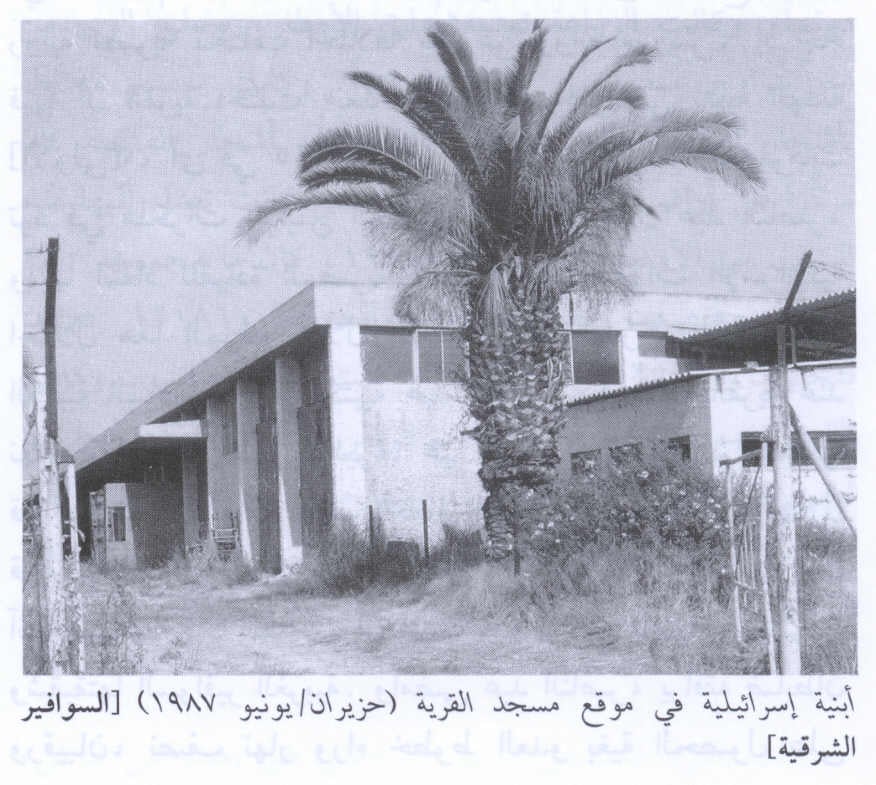
- Israeli Building Built On The Village Mosque Land In 1987
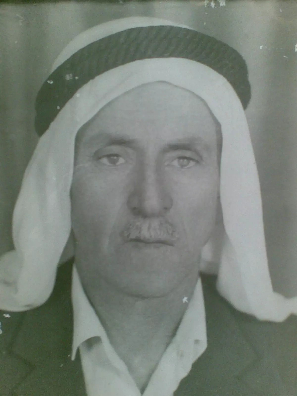
Scanned from "All That Remains" by Dr. Walid Khalidi 18 - صوره مختار قريه السوافير الشرقى بعد الهجره مباشره الشيخ زيدان البحيصى

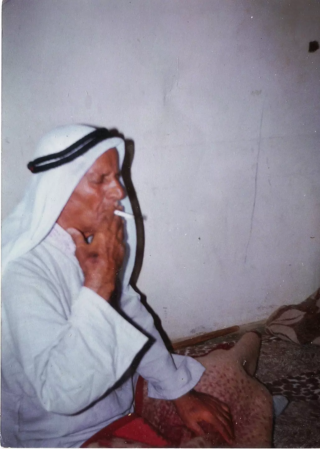
Posted by Khalil Ibrahim Zeidan 28 - الحاج : عوض الله عبد الرحمن العمصي
Posted by mtaa 9 - المرحوم الحاج عوض الله العمصي . في مخيم النصيرات
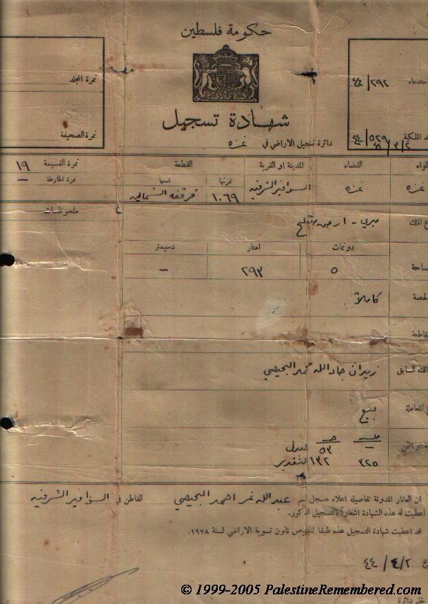
Posted by mtaa 8 - كواشين ارض وفرت لنا غضون مقابلة رمضان البحيسي لتدوين شهادته عن النكبة #4
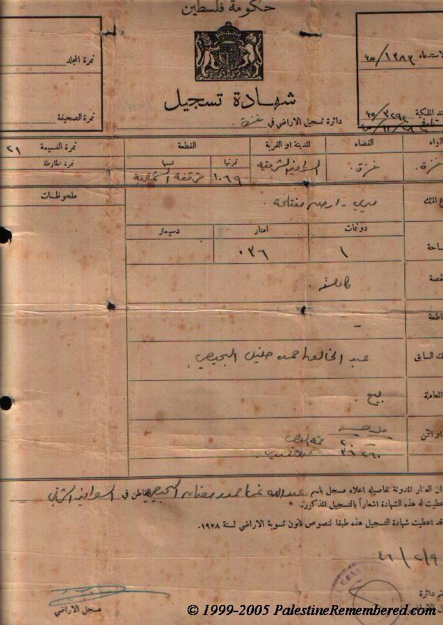
- كواشين ارض وفرت لنا غضون مقابلة رمضان البحيسي لتدوين شهادته عن النكبة
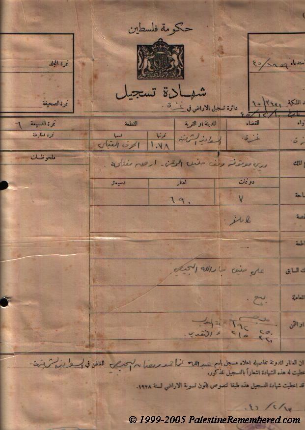
- كواشين ارض وفرت لنا غضون مقابلة رمضان البحيسي لتدوين شهادته عن النكبة #2
- كواشين ارض وفرت لنا غضون مقابلة رمضان البحيسي لتدوين شهادته عن النكبة #3
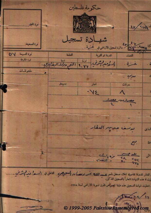
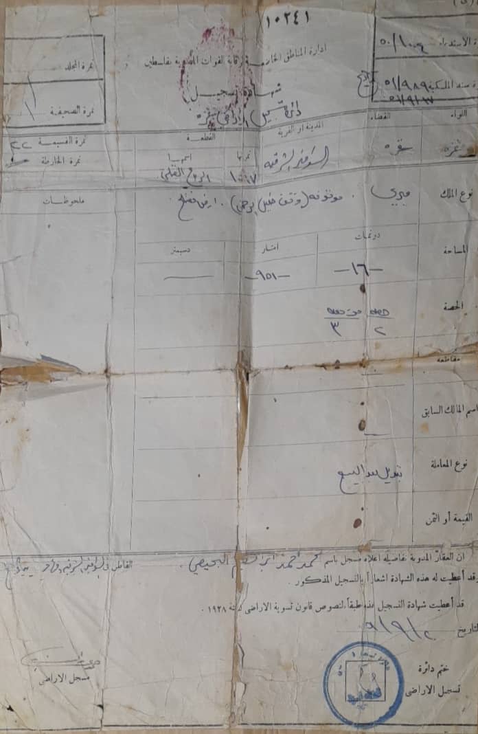
- شهادة تسجيل باسم محمد احمد ابراهيم البحيصي
Posted by ابراهيم البحيصي 1
Want to browse more? 80,000 pictures were grouped in these gallaries:
- كواشين ارض وفرت لنا غضون مقابلة رمضان البحيسي لتدوين شهادته عن النكبة #4
- كواشين ارض وفرت لنا غضون مقابلة رمضان البحيسي لتدوين شهادته عن النكبة
- كواشين ارض وفرت لنا غضون مقابلة رمضان البحيسي لتدوين شهادته عن النكبة #2
- كواشين ارض وفرت لنا غضون مقابلة رمضان البحيسي لتدوين شهادته عن النكبة #3
- شهادة تسجيل باسم محمد احمد ابراهيم البحيصي
Posted by ابراهيم البحيصي 1
| Display Name | Clan/Hamolah | Country of Residence |
| Ghaida Hamdan | Hamdan | AB, Canada |
| نادر جوده | جوده | ميونخ, المانيا |
| عبود | عثمان-جوده | غزه, غزه |
| reem | جوده | القاهره |
| رمضان البحيصي | البحيصي | عمان-الاردن |
| حازم حازم | العمصي | رفح, السوافير |
| بهاء | عثمان | قينا, النمسا |
| نوح | عثمان/جوده | جيزان, السعوديه |
| محمد جمال عبدالقادر البحيصي | - | - |
| طلعت محمود جودة | عثمان/جودة | غزة |
| محمد حنون | - | - |
| Mohammed El-Amassi | العمصي | Berlin, Germany |
| أحمد جابر محمود العمصي | العمصي | غزة, غزة |
| عماد العمصي | العمصي | عمان, الاردن |
| nasser | Hamdan | Oxford |
| علي طلب البحيصي | البحيصي | الأردن |
| مصطفى سعيد البحيصي | - | رام الله-عين عريك |
| أبوصقر | - | الرياض, السعودية |
| imanbhisi | البحيصي | amman, jordan |
| dina buhaisi | buhaisi | amman |
| مجد عثمان | العثامنه(جوده) | ابو ظبي |
| dana al-buheissi | buheissi | - |
| م/ رمزي جادالله العمصي | العمصي | غزة , فلسطين |
| Khalil Ibrahim Zeidan | Al Buheissi | Gaza |
| Zahir Al-Buheissi | - | australia |
| زيدان عبدالهادي البحيصي | البحيصي | جدة, السعودية |
| ابو عبد الله | - | - |
| tarek | hamdan | \devon, UK |
| مصطفى احمد | - | - |
| ReVoLuTiOnIsT iMpRoR | al 3asforey | middle camps, palestine |
| الوحدات | صباح | فلسطين, قفين |
| abu halid | mosleh el wer | sarajevo, bosnia |
 Fake Valor: Why Did Zionist Jews Hoist Nazis Flag on Their Ships in the 1930s?
What is new?
-
Facts About Oct. 7th Gaza Raid
-
Remined Us Please:: Who Did Rape Who? Palestinians Raped Israelis? Or, was the other way around?
-
When Prof. Edward Said was invited to debate Bibi Netanyahu in the 1980s, watch what happened!
-
Ezra Klein of the NY Times on the "Jewish Race".
-
Abusing Blood Libel!
-
Did Israeli Soldiers Activate The Hanniba Direective On Oct. 7th? You Be The Judge
-
Zionist FAQ: Isn't it true that Palestinians don't want peace? Palestinians never accepted the two-state solution
- Facts about Haavara (Transfer) Agreement between Ben-Gurion & Hitler
-
Haavara FAQs: Why Did Zionist Jews Hoist Nazis' Flags on Their Ships in the 1930s?
- Haavara FAQs: When Chaim Weizmann met FDR in mid-1943, why was he silent about rescuing European Jewry?
-
Dear ChatGPT: How did Palestinians resist Napoleon's invasion of their country in 1799?
-
Dear ChatGPT: Gaza had a vibrant Jewish community in the mid-17th century. What happened to them?
-
Dear ChatGPT: Why did the Jewish Agency suppress news of the Holocaust during WWII?
-
Video Playlist: Jews share their DNA tests to end the conflict for good.
-
A Tale of Two Conflicts: Examining the Definition of Genocide
-
Prof. Abraham Polak And The Suppressed History of the Khazars and European Jewry
-
How Ronald Reagan would have framed the genocide in Gaza if he were still alive?
-
Haavara FAQs: Let us do the math: how many German Jews did The Haavara Agreement save?
-
Zionist FAQs: The Hebron Massacre of 1929, "clearly proves" that Palestinians are antisemitic, how could you deny it?
-
Zionist FAQs: Why Anti-Zionist Is Not Antisemitism?
-
Zionist FAQs: Isn't it true that the KGB created Palestinian Nationalism in the early 1960s?
- Zionist FAQs: Muslims are killing Muslims all the time; why are Israeli Jews being singled out in the media?
- Zionist FAQs: How is Israel an apartheid state when 20% of its citizens are Arabs who enjoy full rights?
-
Haavara FAQs: Why Did Dorothy Thompson Flip From A Zionist Advocate to A Silenced Dissenter?
-
Haavara FAQs: Analysis of Herzl's Uganda Scheme and how it could have saved millions of Jews.
-
Haavara FAQs: Why did Hayim Greenberg describe American Jewry as "morally bankrupt" in early 1943?
-
Haavara FAQs: What if the Evian Conference was a resounding success? What would have been the impact of saving European Jewry on Zionism?
- Haavara FAQs: What if the six million were saved, how that would have impacted the Zionist project?
-
Haavara FAQs: How did Zionist leaders react when Europe's Jews lingered in the DP camps after WWII ended?
-
Why does the American Jewish community repeat lies that David Ben-Gurion had debunked before he died?
-
Who has the power to rename the Tatar/Khazar Gene Marker to Jewish IV?
-
Zionist FAQs: Why won't Egypt, Syria, and Jordan take their people back? Jews are indigenous to Palestine, and Arabs immigrated after Jews developed the country. Arabs should leave.
-
Haavara FAQs: Did Hitler and the Nazis conflate between Judaism and Zionist? If that wasn't case, then why?
-
Haavara FAQs: Winston Churchill and antisemitism, a collection of articles written Churchill.
-
Haavara FAQs: Broken by country, how many Jews survived vs. killed during the Holocaust?
-
Haavara FAQs: Why did European Jews vote with their feet and to immigrated to the Americas, not Palestine, after WWII?
-
Watch this American Jewish Girl describing Israeli Jews' cognitive dissonance like no other in under two minutes
-
Haavara FAQs: When the Nazis went out of their way to hide the Holocaust, Israeli Jews did the exact opposite by broadcasting their genocide of Gazans. But why?
-
Haavara FAQs: How Zionist Jews went out of their to show their appreciation to Nazism and Fascism?
- Haavara FAQs: Why Zionist leaders were against bombing the death camps & the Railroads leading to them?
-
Haavara FAQs: Hitler's message to the British and American people: If Jews are such noble citizens and you care about them, how come you're not letting them in? I will gladly ship them to you at my expense, even on luxury liners!
-
A shortlist of Zionist and Israeli false flag operations in the name Jews.
-
The Most Moral Army
- The Land of Kapos (Israel): Where the brave are boycotted and Kapos walk free.
- Why did early Zionists often named their communal enterprises "colonial"?
- Zionist Relations with Nazi Germany by Faris Glubb
-
Two NY Times advertisements by Zionists in the early 1943 that exposes Zionists' treason at the height of the calamity
- Facts Not Lies about the Palestinian-Israeli Conflict.
- Site's pictures have been categorized
- Campgain Against Lice
- A Survey of Palestine, the official source about Palestine before Nakba produced by the British Mandate; over 1200 pages.
- Satellite View & Google Earth: Over 6,000 placemarks identifying all destroyed towns, W. Bank & Gaza Strip Towns, & refugee camps.
- PalestineRemembered.com and its Nakba Oral History Project were featured on al-Jazeera Satellite TV.
- Nakba Oral History Video Podcast:
 Over 700 Oral History interviews (including 3,500+ hours of recording) can be viewed online.
 - Palestine Village Statistics Project
- Gaza Jail Break
- النسخة العربية للموقع الان متوفرة
- Videos: Documenting the destroyed villages in video: Tracing all that remains since Nakba.
- Videos: Responding to Zionist Propaganda
- Interview: The ethnic cleansing of Palestine: George Galloway interviews Israeli Historian Ilan Pappe.
- For Palestinians, memory matters. It provides a blueprint for their future By George Bisharat.
- Zionist FAQ now available in Hebrew שאלות שציונים שואלים, עכשיו בעברית
- Video: The Stephen Walt and John Mearsheimer report on the influence of the Israel Lobby on U.S. Foreign Policy
- The Palestinian-Israeli conflict for beginners
