| PalestineRemembered | About Us | Oral History | العربية | |
| Pictures | Zionist FAQs | Haavara | Maps | |
| Search |
| Camps |
| Districts |
| Acre |
| Baysan |
| Beersheba |
| Bethlehem |
| Gaza |
| Haifa |
| Hebron |
| Jaffa |
| Jericho |
| Jerusalem |
| Jinin |
| Nablus |
| Nazareth |
| Ramallah |
| al-Ramla |
| Safad |
| Tiberias |
| Tulkarm |
| Donate |
| Contact |
| Profile |
| Videos |
Welcome To al-Sawafir al-Shamaliyya - السوافير الشمالية (א-סואפיר א-שמאליה)
|
District of Gaza
Ethnically cleansed days ago |
العربية Google Earth |
 |
Gallery (1) |
- Statistics & Facts
-
Before & After

- Satellite View
- Articles 3
- Pictures 1
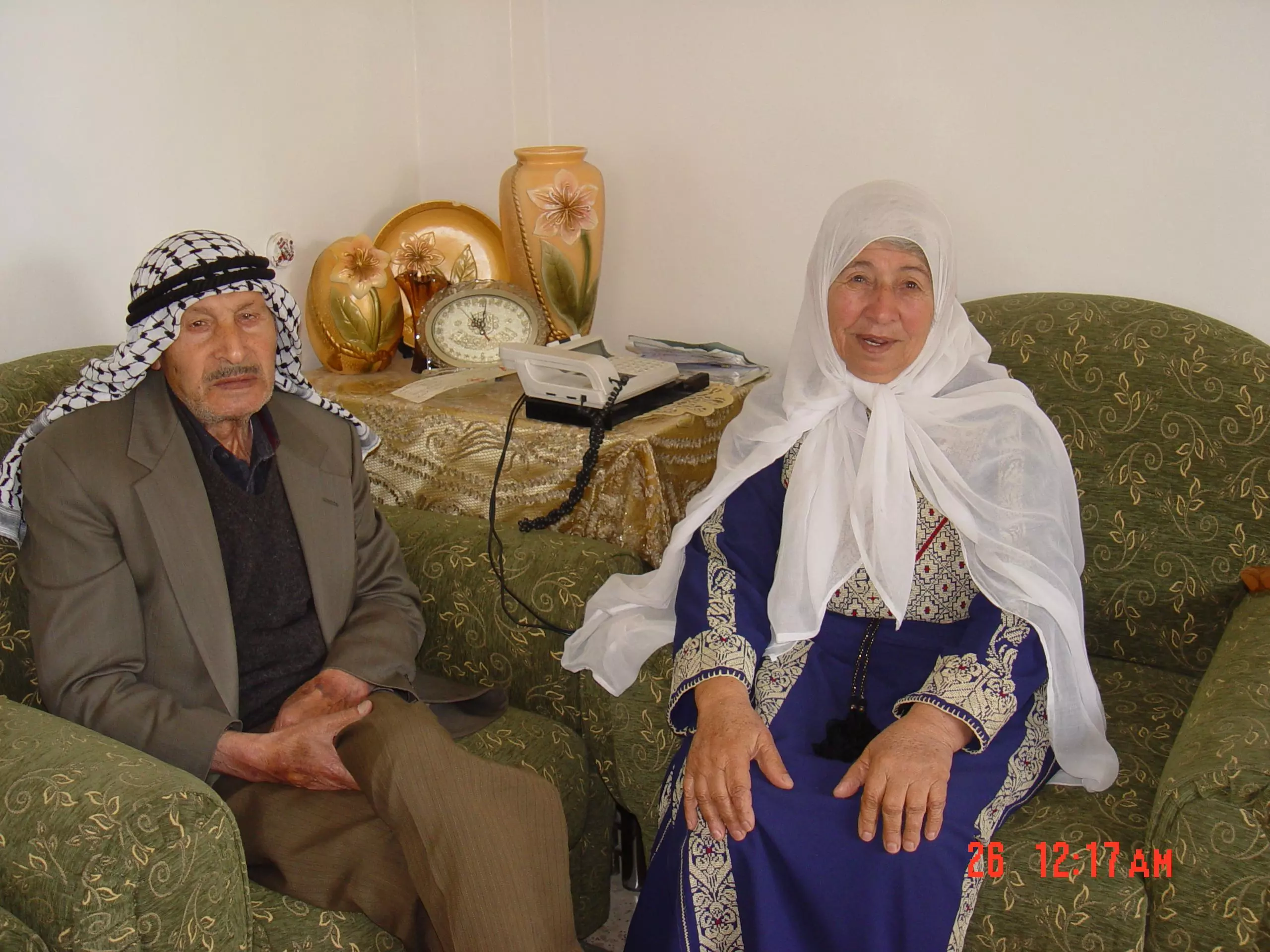
- Oral History 2
- Members 31
- All That Remains
- Wikipedia
- Videos 1
- Guest Book 97
- Links 1
| Statistic & Fact | Value | |||||||||||||||||||||
| Occupation Date | May 18, 1948 | |||||||||||||||||||||
| Distance From District | 33(km) North East of Gaza | |||||||||||||||||||||
| Elevation | 50 (meters) | |||||||||||||||||||||
| Before & After Nakba, Click Map For Details |
||||||||||||||||||||||
|
||||||||||||||||||||||
| Map Location | See location #15 on the map View from satellite |
|||||||||||||||||||||
| Military Operation | Second stage of Operation Barak | |||||||||||||||||||||
| Attacking Units | Possibly Giva'ti Brigade | |||||||||||||||||||||
| Exodus Cause | Fear of Jewish attack, or of being caught in the fighting | |||||||||||||||||||||
| Village Temains | The village has been mostly destroyed with the exception of few deserted houses | |||||||||||||||||||||
| Ethnically Cleansing | al-Sawafir al-Shamaliyya inhabitants were completely ethnically cleansed. | |||||||||||||||||||||
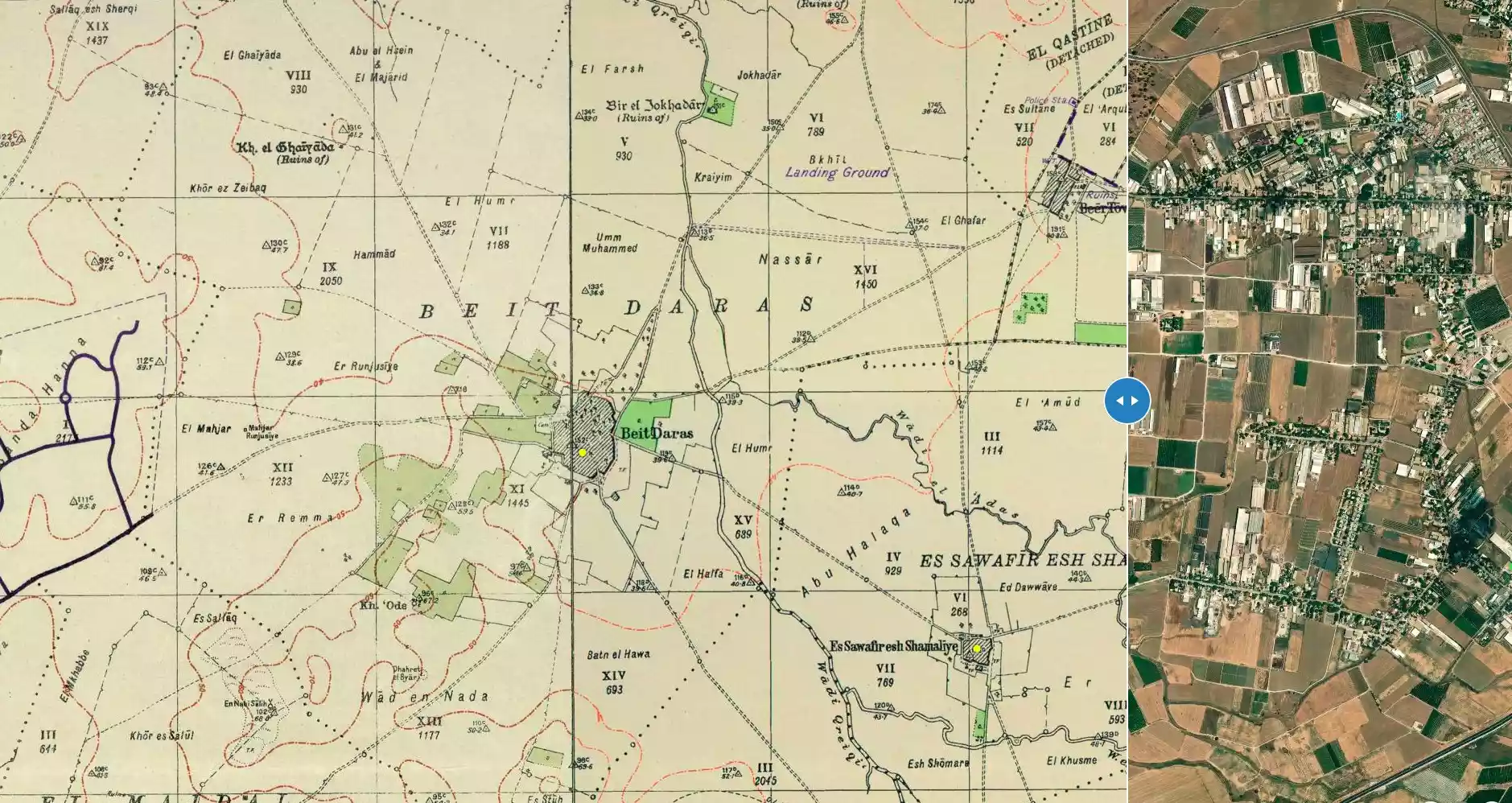
| Pre-Nakba Land Ownership |
**Town Lands' Demarcation Maps |
|||||||||||||||||||||
| Land Usage As of 1945 |
|
|||||||||||||||||||||
| Population |
|
|||||||||||||||||||||
| Number of Houses |
|
|||||||||||||||||||||
| Near By Towns |
||||||||||||||||||||||
|
|
||||||||||||||||||||||
| Town's Name Through History | The Crusades called the village Zeophir, and the Ottomans records referred to it by Sawafir al-Halil. | |||||||||||||||||||||
| Schools | The village shared a school with the other two Sawafir villages, and in 1945 it had an enrollment of about 280. | |||||||||||||||||||||
| Places of Warship | One mosque | |||||||||||||||||||||
| Archeological Sites | The village contained pieces of marble and the shafts and capitals of ancient columns. | |||||||||||||||||||||
| Exculsive Jewish Colonies Who Usurped Village Lands |
No settlements on village lands. | |||||||||||||||||||||
| Featured Video | ||||||||||||||||||||||
Village Before NakbaThe village stood on the coastal plain, a short distance to the north of a highway between al-Majdal, Ramla, and the Jerusalem–Jaffa highway. The second, adjectival, part of its name, al-Shamaliyya ('northern') distinguished it from two other neighboring villages with the same first name, al-Sawafir. Together they formed an approximately right-angled triangle, with a northwest-southeast hypotenuse. Al-Sawafir al-Shamaliyya may have been located on the site of the biblical Shafir (Micah 1:11), mentioned by Eusebius (A.D. 266–340), the Palestine-born Byzantine historian. Eusebius said that in his days it was a beautiful town between Ascalon and Bayt Jibrin . Most modern scholars, however, locate Shafir at Khirbat al-Qawm rather than at the site of al-Sawafir al-Shamaliyya. The Crusader name of the village was Zeophir; they recorded that it was the property of the Bishop of Jerusalem in the early twelfth century. The village appears in the Ottoman records for the sixteenth century as 'Sawafir al-Halil.' It belonged to the nahiya of Gaza (liwa' of Gaza) and had a population of 616. The village paid taxes on wheat, barley, olive trees, and fruit trees.In the late nineteenth century, the village of al-Sawafir al-Shamaliyya had several small gardens and wells. Many of its houses were built of adobe, although a few were made of stone. The residents were Muslim, and the village had its own mosque but shared a school with the other two villages. The number of students in the school was about 280 in the mid-1940s. Agriculture, which was mainly rainfed, constituted the backbone of the economy, and grain, citrus, grapes, and apricots were grown. In 1944/45 a total of 481 dunums was devoted to citrus and bananas and 4,632 dunums were allocated to cereals; 10 dunums were irrigated or used for orchards. Al-Sawafir al-Gharbiyya contained archaeological remains, such as pieces of marble and the shafts and capitals of ancient columns. Village Occupation and Ethnic CleaningLike its sister villages (al-Sawafir al-Sharqiyya and al-Sawafir al-Gharbiyya), al-Sawafir al-Shamaliyya was occupied in Operation Barak . Its villagers may have been pushed out by the attack on Bayt Daras on 10 May, which was preceded by a mortar attack. But it is more likely that they left during an attack on the village itself that led to its capture on 12 May (along with nearby Bashshit), according to an Associated Press dispatch which quoted a Haganah source. Israeli historian Benny Morris claims, probably incorrectly, that the villagers fled in May, at the time of the attack on al-Sawafir al-Sharqiyya. The History of the War of Independence states that at the end of the first truce of the war (early July 1948), Egyptian and Sudanese forces planned to capture the three sister villages, but were prevented from doing so at an early stage.Zionists Colonies on Village LandsThere are no Israeli settlements on the lands of al-Sawafir al-Shamaliyya. The determination of locations for several settlements in the area is complicated by the numerous changes in their names since they were founded.Village TodayA few vacant houses and segments of houses, standing amidst wild vegetation, mark the site. One of them has a covered porch supported on two columns. An old village road is also identifiable, and cactuses and fig trees grow on the site. The surrounding lands are cultivated.SourceDr. Walid al-Khalidi, 1992: All That Remains. |
||||||||||||||||||||||
| Related Maps | Town Lands' Demarcation Maps خرائط للقضاء توضح حدود القرى والاودية Town's map on MapQuest View from satellite Help us map this town at WikiMapia |
|||||||||||||||||||||
| Related Links | Wikipedia's Page Facebook Page Google Search Google For Images Google For Videos |
|||||||||||||||||||||
| More Information | في كتاب كي لا ننسى في كتاب بلادنا فلسطين المزيد من موقع هوية |
|||||||||||||||||||||
Want to browse more? 80,000 pictures were grouped in these gallaries:
| Display Name | Clan/Hamolah | Country of Residence |
| Hussein hosam ismail | Ismail | Birmingham |
| abu rami | - | amman |
| السماعيل | - | - |
| Samar | - | Saudi arabia, KSA |
| ابو ناجي | ناجي | الاردن, الاردن |
| أماني رأفت اسماعيل | اسماعيل | jordan |
| زيد محمود ناجي | - | الاردن, الاردن |
| medo | الناجي | - |
| abo al nooj | naji | amman |
| Alaa | - | Abu Dhabi, UAE |
| nisreen abdel_jawad | Abdel_Jawad | Amman, Jordan |
| سعد | ناجي | دير البلح |
| samer abd al jawad | أل رباح | عمان |
| abu alqasim | - | aj, uae |
| Muneera Ismail | Ismail | Riyadh- Ksa |
| Saad Yousf Rabah | Rabah | UAE |
| صالح ناجي | ناجي | عمان, الاردن |
| لاجيء1981 | ناجي | - |
| Hussam Rabah | Rabah | - |
| Yousef Al-Faqi | Al-Faqi | - |
| mohmad rabah | - | - |
| abo rabah | abdalgawad | libya, libya |
| Amassi | Al-Amassi | Saarland, Germany |
| Iyad Ismail | Ismail | UK |
| Mohamed Yousef Abd Eljawwad | Abd Eljawwad | Gaza Strip, Palestine |
| Amal Abdulwahab | Ismael | Abu Dhabi, UAE |
| Malik Abdul-Haiy | Ismail | Riyadh, Saudi Arabia |
| Anas Abdul-haiy | Ismail | Riyadh, Saudi arabia |
| amassi | al-amassi | nova scotia, canada |
| Raed Hamdan | Abduljawad | Palestine, Palestine |
| abduljawad rabah | rabah | usa |
 Fake Valor: Why Did Zionist Jews Hoist Nazis Flag on Their Ships in the 1930s?
What is new?
-
Facts About Oct. 7th Gaza Raid
-
Remined Us Please:: Who Did Rape Who? Palestinians Raped Israelis? Or, was the other way around?
-
When Prof. Edward Said was invited to debate Bibi Netanyahu in the 1980s, watch what happened!
-
Abusing Blood Libel!
-
Zionist FAQ: Isn't it true that Palestinians don't want peace? Palestinians never accepted the two-state solution
- Facts about Haavara (Transfer) Agreement between Ben-Gurion & Hitler
-
Haavara FAQs: Why Did Zionist Jews Hoist Nazis' Flags on Their Ships in the 1930s?
-
Dear ChatGPT: Why did the Jewish Agency suppress news of the Holocaust during WWII?
-
Video Playlist: Jews share their DNA tests to end the conflict for good.
-
A Tale of Two Conflicts: Examining the Definition of Genocide
-
Prof. Abraham Polak And The Suppressed History of the Khazars and European Jewry
-
How Ronald Reagan would have framed the genocide in Gaza if he were still alive?
-
Haavara FAQs: Let us do the math: how many German Jews did The Haavara Agreement save?
-
Zionist FAQs: The Hebron Massacre of 1929, "clearly proves" that Palestinians are antisemitic, how could you deny it?
-
Zionist FAQs: Why Anti-Zionist Is Not Antisemitism?
-
Zionist FAQs: Isn't it true that the KGB create Palestinian Nationalism in the early 1960s?
- Zionist FAQs: Muslims are killing Muslims all the time; why are Israeli Jews being singled out in the media?
- Zionist FAQs: How is Israel an apartheid state when 20% of its citizens are Arabs who enjoy full rights?
-
Haavara FAQs: Analysis of Herzl's Uganda Scheme and how it could have saved millions of Jews.
-
Haavara FAQs: Why did Hayim Greenberg describe American Jewry as "morally bankrupt" in early 1943?
-
Haavara FAQs: What if the Evian Conference was a resounding success? What would have been the impact of saving European Jewry on Zionism?
- Haavara FAQs: What if the six million were saved, how that would have impacted the Zionist project?
-
Haavara FAQs: How did Zionist leaders react when Europe's Jews lingered in the DP camps after WWII ended?
-
Why does the American Jewish community repeat lies that David Ben-Gurion had debunked before he died?
-
Who has the power to rename the Tatar/Khazar Gene Marker to Jewish IV?
-
Zionist FAQs: Why won't Egypt, Syria, and Jordan take their people back? Jews are indigenous to Palestine, and Arabs immigrated after Jews developed the country. Arabs should leave.
-
Haavara FAQs: Did Hitler and the Nazis conflate between Judaism and Zionist? If that wasn't case, then why?
-
Haavara FAQs: Winston Churchill and antisemitism, a collection of articles written Churchill.
-
Haavara FAQs: Broken by country, how many Jews survived vs. killed during the Holocaust?
-
Haavara FAQs: Why did European Jews vote with their feet and to immigrated to the Americas, not Palestine, after WWII?
-
Watch this American Jewish Girl describing Israeli Jews' cognitive dissonance like no other in under two minutes
-
Haavara FAQs: When the Nazis went out of their way to hide the Holocaust, Israeli Jews did the exact opposite by broadcasting their genocide of Gazans. But why?
-
Haavara FAQs: How Zionist Jews went out of their to show their appreciation to Nazism and Fascism?
- Haavara FAQs: Why Zionist leaders were against bombing the death camps & the Railroads leading to them?
-
Haavara FAQs: Hitler's message to the British and American people: If Jews are such noble citizens and you care about them, how come you're not letting them in? I will gladly ship them to you at my expense, even on luxury liners!
-
A shortlist of Zionist and Israeli false flag operations in the name Jews.
-
The Most Moral Army
- The Land of Kapos (Israel): Where the brave are boycotted and Kapos walk free.
- Why did early Zionists often named their communal enterprises "colonial"?
- Zionist Relations with Nazi Germany by Faris Glubb
-
Two NY Times advertisements by Zionists in the early 1943 that exposes Zionists' treason at the height of the calamity
- Facts Not Lies about the Palestinian-Israeli Conflict.
- Site's pictures have been categorized
- Campgain Against Lice
- A Survey of Palestine, the official source about Palestine before Nakba produced by the British Mandate; over 1200 pages.
- Satellite View & Google Earth: Over 6,000 placemarks identifying all destroyed towns, W. Bank & Gaza Strip Towns, & refugee camps.
- PalestineRemembered.com and its Nakba Oral History Project were featured on al-Jazeera Satellite TV.
- Nakba Oral History Video Podcast:
 Over 700 Oral History interviews (including 3,500+ hours of recording) can be viewed online.
 - Palestine Village Statistics Project
- Gaza Jail Break
- النسخة العربية للموقع الان متوفرة
- Videos: Documenting the destroyed villages in video: Tracing all that remains since Nakba.
- Videos: Responding to Zionist Propaganda
- Interview: The ethnic cleansing of Palestine: George Galloway interviews Israeli Historian Ilan Pappe.
- For Palestinians, memory matters. It provides a blueprint for their future By George Bisharat.
- Zionist FAQ now available in Hebrew שאלות שציונים שואלים, עכשיו בעברית
- Video: The Stephen Walt and John Mearsheimer report on the influence of the Israel Lobby on U.S. Foreign Policy
- The Palestinian-Israeli conflict for beginners
