| PalestineRemembered | About Us | Oral History | العربية | |
| Pictures | Zionist FAQs | Haavara | Maps | |
| Search |
| Camps |
| Districts |
| Acre |
| Baysan |
| Beersheba |
| Bethlehem |
| Gaza |
| Haifa |
| Hebron |
| Jaffa |
| Jericho |
| Jerusalem |
| Jinin |
| Nablus |
| Nazareth |
| Ramallah |
| al-Ramla |
| Safad |
| Tiberias |
| Tulkarm |
| Donate |
| Contact |
| Profile |
| Videos |
Welcome To al-Sawafir al-Gharbiyya - السوافير الغربية (א-סואפיר אל-ע'רביה)
|
District of Gaza
Ethnically cleansed days ago |
العربية Google Earth |
 |
Gallery (2) |
- Statistics & Facts
-
Before & After

- Satellite View
- Articles 1
- Pictures 2
- Oral History 4
- Members 20
- All That Remains
- Wikipedia
- Videos
- Guest Book 5
- Links 1
| Statistic & Fact | Value | ||||||||||||||
| Occupation Date | May 18, 1948 | ||||||||||||||
| Distance From District | 30 (km) North East of Gaza | ||||||||||||||
| Elevation | 50 (meters) | ||||||||||||||
| Before & After Nakba, Click Map For Details |
|||||||||||||||
|
|||||||||||||||
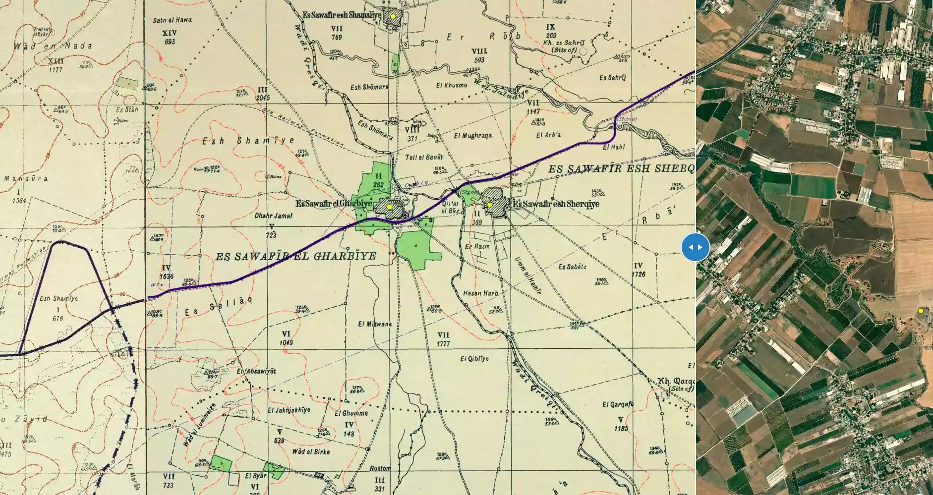
| Map Location | See location #14 on the map View from satellite |
||||||||||||||
| Military Operation | Second stage of Operation Barak | ||||||||||||||
| Attacking Units | Possibly Giva'ti Brigade | ||||||||||||||
| Exodus Cause | Fear of Jewish attack, or of being caught in the fighting | ||||||||||||||
| Village Temains | The village has been mostly destroyed with the exception of its cemetery. | ||||||||||||||
| Ethnically Cleansing | al-Sawafir al-Gharbiyya inhabitants were completely ethnically cleansed. | ||||||||||||||
| Pre-Nakba Land Ownership |
**Town Lands' Demarcation Maps |
||||||||||||||
| Land Usage As of 1945 |
|
||||||||||||||
| Population |
|
||||||||||||||
| Number of Houses |
|
||||||||||||||
| Near By Towns |
|||||||||||||||
|
|||||||||||||||
| Schools | al-Sawafir al-Gharbiyya shared a school with the other two Sawafir villages, and in 1945 it had an enrollment of about 280. | ||||||||||||||
| Shrines / Maqams | A shrine for local sage al-Shaykh al-Baz | ||||||||||||||
| Archeological Sites | The village contained the fragmentary remains of earlier occupation. | ||||||||||||||
| Exculsive Jewish Colonies Who Usurped Village Lands |
Merkaz Shappira, Massu'ot Yitzchaq, and 'En Tzurim | ||||||||||||||
| Featured Video | |||||||||||||||
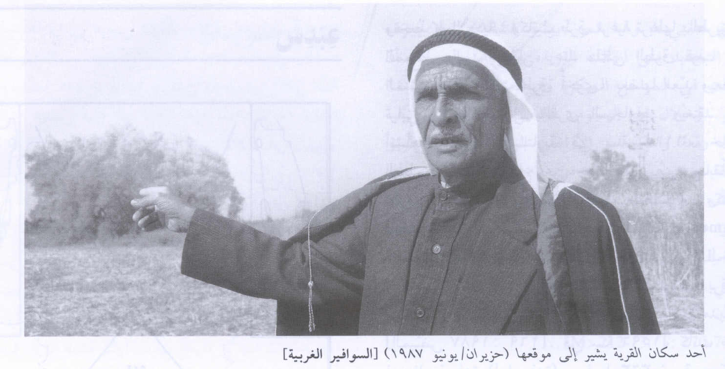
Village Before NakbaThe village stood on the coastal plain, north of the highway that ran northeastwards from the city of al-Majdal to a point where it crossed the Jerusalem–Jaffa highway. The railroad to Gaza passed just north of the village. The adjectival al-Gharbiyya ('western') was added to its name to distinguish it from the two other neighboring villages with the same first name (al-Sawafir). Together they formed a right triangle, with a northeast-southwest hypotenuse. In 1596, al-Sawafir al-Gharbiyya was a village in the nahiya of Gaza (liwa' of Gaza), with a population of 237. It paid taxes on a number of crops, including wheat, barley, and fruits, as well as on other types of produce and property, such as goats, beehives, and vineyards.In the late nineteenth century, the village of al-Sawafir al-Gharbiyya had several small gardens and wells. Most of its houses were built of mud and adobe bricks, although a few were made of stone. The village had a mosque—its population was Muslim—and a shrine for one Shaykh al-Baz. It also had a police station. It shared a school with the other two villages; the school had an enrollment of about 280 in the mid-1940s. Agriculture, which was mainly rainfed, constituted the backbone of the economy. Grain, citrus, grapes, and apricots were grown on the land. In 1944/45 a total of 6,663 dunums was allotted to cereals; 585 dunums were irrigated or used for orchards. Al-Sawafir al-Gharbiyya contained the fragmentary remains of earlier occupation. The maqam for Shaykh al-Baz, for example, contained reused columns. Village Occupation and Ethnic CleaningThe village fell in the early stages of Operation Barak , according to two Israeli sources. The inhabitants of the village were driven out, either following the extensive attack on nearby Bayt Daras on 10 May 1948, or during the direct military attack on its sister village, al-Sawafir al-Sharqiyya, on 18 May. The village itself may also have been attacked on that day.One Egyptian account claims that the village was not taken until over a month later, two weeks into the first truce of the war. The account given by the late Egyptian president Gamal Abdel Nasser, who was a junior officer at the time, chastises the Egyptian military command for allowing the village to be occupied, along with two others. He writes that on the day the truce was announced, the villages were empty of Israeli troops, adding ironically that 'our High Command had preferred to present the enemy with the opportunity of occupying them so that our troops could recover them by assault.' As hostilities resumed on 9 July, Abdel Nasser's battalion was given orders to recapture the village. The occupation was dependent upon the capture of Bayt Daras, which was briefly entered by a Sudanese unit but relinquished due to a careless error. In the meantime, Abdel Nasser organized a reconnaissance maneuver of the site, penetrating behind enemy lines in order to draw up a plan of attack. He recalls that the Israeli force in the al-Sawafir villages was a small one. The History of the War of Independence confirms that the Egyptians planned to capture the village in early July, but were prevented from doing so after a Sudanese force was ousted from Bayt Daras. Zionists Colonies on Village LandsTwo settlements were established on village land: Merkaz Shappira , built in 1948, and Massu'ot Yitzcha, built in 1949. En Tzurim was built nearby in 1949 on land belonging to al-Sawafir al-Sharqiyya. The determination of the settlement locations is complicated by the numerous changes in their names since they were founded. Furthermore, the settlement of Deganim seems to have been moved from its original site on the lands of al-Sawafir al-Gharbiyya to join the settlement of En Tzurim.Village TodayAll of the houses are gone. Some cactuses and fig and sycamore trees grow on the site. An old village road is clearly visible. The cemetery is overgrown with wild vegetation. One can see the debris of (what appears to be) a water-pump building in the al-Baz orchard . The adjacent lands are cultivated by Israeli farmers.SourceDr. Walid al-Khalidi, 1992: All That Remains. |
|||||||||||||||
| Related Maps | Town Lands' Demarcation Maps خرائط للقضاء توضح حدود القرى والاودية Town's map on MapQuest View from satellite Help us map this town at WikiMapia |
||||||||||||||
| Related Links | Wikipedia's Page Facebook Page Google Search Google For Images Google For Videos |
||||||||||||||
| More Information | في كتاب كي لا ننسى في كتاب بلادنا فلسطين المزيد من موقع هوية |
||||||||||||||
- The remnants of the village pump-house, 1987

Scanned from "All That Remains" by Dr. Walid Khalidi 6 - Villager Pointing To The Village Site In 1987
Scanned from "All That Remains" by Dr. Walid Khalidi
Want to browse more? 80,000 pictures were grouped in these gallaries:
| Display Name | Clan/Hamolah | Country of Residence |
| Heba Abuabdou | - | Riyadh, Saudi Arabia |
| maher afana | afana | ---, -United Kingdom-manchester |
| رائف محمود عطالله | - | - |
| eattalah | - | - |
| samara | - | Amman , Jordan |
| أبو خليل | - | الرياض, السعودية |
| ابو محمد | الحبيبي | الاردن -عمان, وادي السير |
| أبوقيس | الحبيبي | رفح, السوافير الغربية |
| ابوكرم | شحاده | غزه, غزه |
| شحادة | شحادة | غزه |
| وسام الباز | - | غزة |
| Ayman Abu-Abdou | Al-Sawafir Al-Gharbiyya | Palestine |
| Naim1948 | Afana | Gaza |
| mohammad sawalha | - | - |
| asd asd | - | - |
| abed nofal | nofal | manchester, uk |
| Moe | - | Amman, Jordan |
| Abu Yazan | Dabboor | Istanbul, Turkey |
| Ahmed Khalil Mahmoud ABU-ABDOU | Coosa | Vienna, Austria |
| Mahmoud Abu-Abdou | Abu Khalil | Riyadh, Saudi Arabia |
 Fake Valor: Why Did Zionist Jews Hoist Nazis Flag on Their Ships in the 1930s?
What is new?
-
Facts About Oct. 7th Gaza Raid
-
Remined Us Please:: Who Did Rape Who? Palestinians Raped Israelis? Or, was the other way around?
-
When Prof. Edward Said was invited to debate Bibi Netanyahu in the 1980s, watch what happened!
-
Ezra Klein of the NY Times on the "Jewish Race".
-
Abusing Blood Libel!
-
Zionist FAQ: Isn't it true that Palestinians don't want peace? Palestinians never accepted the two-state solution
- Facts about Haavara (Transfer) Agreement between Ben-Gurion & Hitler
-
Haavara FAQs: Why Did Zionist Jews Hoist Nazis' Flags on Their Ships in the 1930s?
- Haavara FAQs: When Chaim Weizmann met FDR in mid-1943, why was he silent about rescuing European Jewry?
-
Dear ChatGPT: How did Palestinians resist Napoleon's invasion of their country in 1799?
-
Dear ChatGPT: Gaza had a vibrant Jewish community in the mid-17th century. What happened to them?
-
Dear ChatGPT: Why did the Jewish Agency suppress news of the Holocaust during WWII?
-
Video Playlist: Jews share their DNA tests to end the conflict for good.
-
A Tale of Two Conflicts: Examining the Definition of Genocide
-
Prof. Abraham Polak And The Suppressed History of the Khazars and European Jewry
-
How Ronald Reagan would have framed the genocide in Gaza if he were still alive?
-
Haavara FAQs: Let us do the math: how many German Jews did The Haavara Agreement save?
-
Zionist FAQs: The Hebron Massacre of 1929, "clearly proves" that Palestinians are antisemitic, how could you deny it?
-
Zionist FAQs: Why Anti-Zionist Is Not Antisemitism?
-
Zionist FAQs: Isn't it true that the KGB create Palestinian Nationalism in the early 1960s?
- Zionist FAQs: Muslims are killing Muslims all the time; why are Israeli Jews being singled out in the media?
- Zionist FAQs: How is Israel an apartheid state when 20% of its citizens are Arabs who enjoy full rights?
-
Haavara FAQs: Analysis of Herzl's Uganda Scheme and how it could have saved millions of Jews.
-
Haavara FAQs: Why did Hayim Greenberg describe American Jewry as "morally bankrupt" in early 1943?
-
Haavara FAQs: What if the Evian Conference was a resounding success? What would have been the impact of saving European Jewry on Zionism?
- Haavara FAQs: What if the six million were saved, how that would have impacted the Zionist project?
-
Haavara FAQs: How did Zionist leaders react when Europe's Jews lingered in the DP camps after WWII ended?
-
Why does the American Jewish community repeat lies that David Ben-Gurion had debunked before he died?
-
Who has the power to rename the Tatar/Khazar Gene Marker to Jewish IV?
-
Zionist FAQs: Why won't Egypt, Syria, and Jordan take their people back? Jews are indigenous to Palestine, and Arabs immigrated after Jews developed the country. Arabs should leave.
-
Haavara FAQs: Did Hitler and the Nazis conflate between Judaism and Zionist? If that wasn't case, then why?
-
Haavara FAQs: Winston Churchill and antisemitism, a collection of articles written Churchill.
-
Haavara FAQs: Broken by country, how many Jews survived vs. killed during the Holocaust?
-
Haavara FAQs: Why did European Jews vote with their feet and to immigrated to the Americas, not Palestine, after WWII?
-
Watch this American Jewish Girl describing Israeli Jews' cognitive dissonance like no other in under two minutes
-
Haavara FAQs: When the Nazis went out of their way to hide the Holocaust, Israeli Jews did the exact opposite by broadcasting their genocide of Gazans. But why?
-
Haavara FAQs: How Zionist Jews went out of their to show their appreciation to Nazism and Fascism?
- Haavara FAQs: Why Zionist leaders were against bombing the death camps & the Railroads leading to them?
-
Haavara FAQs: Hitler's message to the British and American people: If Jews are such noble citizens and you care about them, how come you're not letting them in? I will gladly ship them to you at my expense, even on luxury liners!
-
A shortlist of Zionist and Israeli false flag operations in the name Jews.
-
The Most Moral Army
- The Land of Kapos (Israel): Where the brave are boycotted and Kapos walk free.
- Why did early Zionists often named their communal enterprises "colonial"?
- Zionist Relations with Nazi Germany by Faris Glubb
-
Two NY Times advertisements by Zionists in the early 1943 that exposes Zionists' treason at the height of the calamity
- Facts Not Lies about the Palestinian-Israeli Conflict.
- Site's pictures have been categorized
- Campgain Against Lice
- A Survey of Palestine, the official source about Palestine before Nakba produced by the British Mandate; over 1200 pages.
- Satellite View & Google Earth: Over 6,000 placemarks identifying all destroyed towns, W. Bank & Gaza Strip Towns, & refugee camps.
- PalestineRemembered.com and its Nakba Oral History Project were featured on al-Jazeera Satellite TV.
- Nakba Oral History Video Podcast:
 Over 700 Oral History interviews (including 3,500+ hours of recording) can be viewed online.
 - Palestine Village Statistics Project
- Gaza Jail Break
- النسخة العربية للموقع الان متوفرة
- Videos: Documenting the destroyed villages in video: Tracing all that remains since Nakba.
- Videos: Responding to Zionist Propaganda
- Interview: The ethnic cleansing of Palestine: George Galloway interviews Israeli Historian Ilan Pappe.
- For Palestinians, memory matters. It provides a blueprint for their future By George Bisharat.
- Zionist FAQ now available in Hebrew שאלות שציונים שואלים, עכשיו בעברית
- Video: The Stephen Walt and John Mearsheimer report on the influence of the Israel Lobby on U.S. Foreign Policy
- The Palestinian-Israeli conflict for beginners
