| PalestineRemembered | About Us | Oral History | العربية | |
| Pictures | Zionist FAQs | Haavara | Maps | |
| Search |
| Camps |
| Districts |
| Acre |
| Baysan |
| Beersheba |
| Bethlehem |
| Gaza |
| Haifa |
| Hebron |
| Jaffa |
| Jericho |
| Jerusalem |
| Jinin |
| Nablus |
| Nazareth |
| Ramallah |
| al-Ramla |
| Safad |
| Tiberias |
| Tulkarm |
| Donate |
| Contact |
| Profile |
| Videos |
Welcome To al-Wayziyya - الويزية (אל-ויזיה)
|
District of Safad
Ethnically cleansed days ago |
العربية Google Earth |
| Gallery (3) |
- Statistics & Facts
-
Before & After

- Satellite View
- Articles 1
- Pictures 3
- Members
- All That Remains
- Wikipedia
- Videos
- Guest Book
- Links
| Statistic & Fact | Value | |||||||||||||||
| Occupation Date | May 1, 1948 | |||||||||||||||
| Distance From District | 8.5 (km) North East of Safad | |||||||||||||||
| Elevation | 250 (meters) | |||||||||||||||
| Before & After Nakba, Click Map For Details |
||||||||||||||||

|
||||||||||||||||
| Map Location | See location #56 on the map View from satellite |
|||||||||||||||
| Military Operation | Operation Yiftach (commanded by the ethnic cleansing champion Yigal Allon) | |||||||||||||||
| Attacking Units | The Palmach's First Battalion | |||||||||||||||
| Exodus Cause | Military assault by Zionist troops | |||||||||||||||
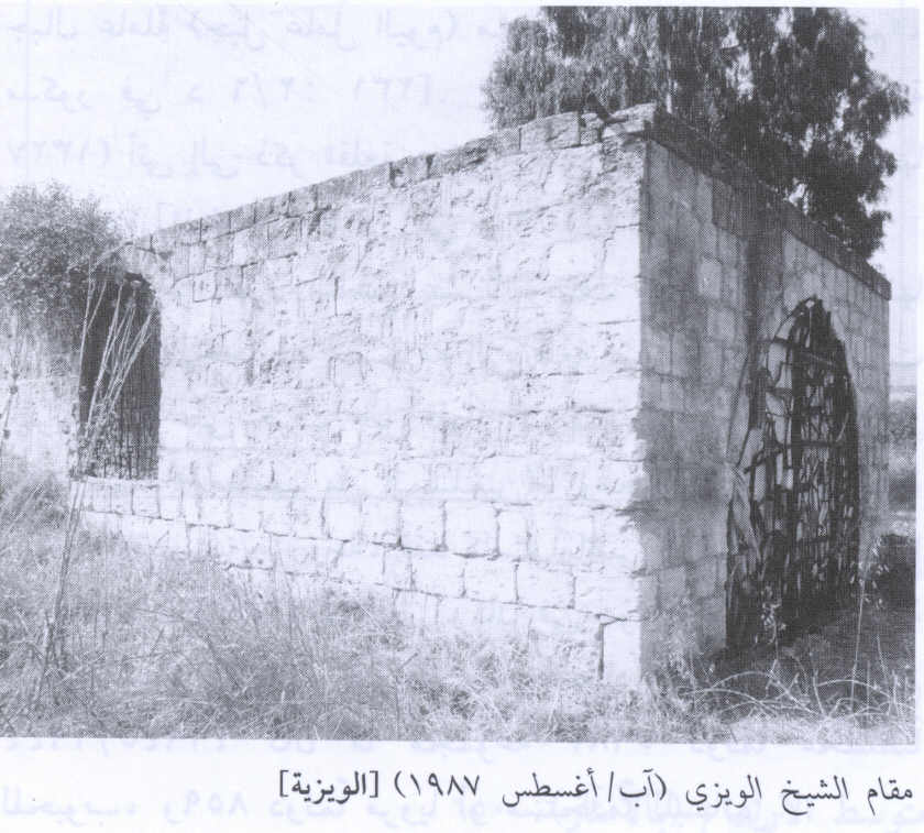
| Village Temains | The village has been completely destroyed with exception of al-Shaykh al-Wayzi shrine. | |||||||||||||||
| Ethnically Cleansing | al-Wayziyya inhabitants were completely ethnically cleansed. | |||||||||||||||
| Pre-Nakba Land Ownership |
**Town Lands' Demarcation Maps |
|||||||||||||||
| Land Usage As of 1945 |
|
|||||||||||||||
| Population |
|
|||||||||||||||
| Near By Towns |
||||||||||||||||
|
||||||||||||||||
| Shrines / Maqams | A shrine for a local sage known by al-Shaykh al-Wayzi. | |||||||||||||||
| Exculsive Jewish Colonies Who Usurped Village Lands |
The settlement Machanayim is nearby village lands | |||||||||||||||
Village Before NakbaThe village was situated in an area underlain by volcanic rocks that sloped toward the al-Hula Plain to the north. A secondary road linked al-Wayziyya to a highway leading to Safad and Tiberias. A shrine for a Shaykh al-Wayzi lay about 0.5 km from the site; to the west of the shrine there was a stone quarry. The bulk of the villagers were Bedouin, who earned their livelihood from animal husbandry, and to a smaller extent from crop cultivation.Village Occupation and Ethnic CleaningThe capture of al-Wayziyya occurred in April or May 1948, within the scope of Operation Yiftah. Nearby Mughr al-Khayt (200266) was hit by mortars on 2 May, while villages to the north were evacuated in late April in anticipation of a Haganah attack. It probably fell some time before the final assault on Safad on 10 May, as Zionist forces pushed into the city's hinterland before encircling and occupying it. [M:102–5, 120–24]Zionists Colonies on Village LandsThere are no Israeli settlements on village lands. Zionists established the settlement of Machanayim (203266) in 1939, 1.5 km southeast of the village site.Village TodayThe shrine of Shaykh al-Wayzi is the only remaining landmark. Rubble from destroyed houses is scattered over the site. Grasses, together with Christ's-thorn, eucalyptus, and pine trees, grow on the surrounding land, which is used by Israelis primarily as pasture.SourceDr. Walid al-Khalidi, 1992: All That Remains. |
||||||||||||||||
| Related Maps | Town Lands' Demarcation Maps خرائط للقضاء توضح حدود القرى والاودية Town's map on MapQuest View from satellite Help us map this town at WikiMapia |
|||||||||||||||
| Related Links | Wikipedia's Page Google Search Google For Images Google For Videos |
|||||||||||||||
| More Information | في كتاب كي لا ننسى المزيد من موقع هوية |
|||||||||||||||
- The Shrine Of Shaykh al-Wayzi In 1987
Scanned from "All That Remains" by Dr. Walid Khalidi - الويزية
Posted by أحمد الحلواني - خارطة تُظهِر الحدود والطرق بأنواعها والأماكن المقدسة والطبيعة الطوبغرافية من تلال وسهول ومنحدرات والتشكيلة الطبيعية للأرض وأنواع المزروعات. نُشرت الخريطة فترة الانتداب البريطاني، تم إضافة تعديلات عليها من قِبَل خدمة الخرائط والصور التابعة للقوات العسكرية الاسرائيلية فترة الأربعينيات.
Want to browse more? 80,000 pictures were grouped in these gallaries:
| Display Name | Clan/Hamolah | Country of Residence |
No links have been shared yet, be free to the first to share the first link.


