| PalestineRemembered | About Us | Oral History | العربية | |
| Pictures | Zionist FAQs | Haavara | Maps | |
| Search |
| Camps |
| Districts |
| Acre |
| Baysan |
| Beersheba |
| Bethlehem |
| Gaza |
| Haifa |
| Hebron |
| Jaffa |
| Jericho |
| Jerusalem |
| Jinin |
| Nablus |
| Nazareth |
| Ramallah |
| al-Ramla |
| Safad |
| Tiberias |
| Tulkarm |
| Donate |
| Contact |
| Profile |
| Videos |
Welcome To al-Mansura - المنصورة (אל-מנצורה)
|
District of al-Ramla
Ethnically cleansed days ago |
العربية Google Earth |
 |
Gallery (16) |
- Statistics & Facts
-
Before & After

- Satellite View
- Articles 1
- Pictures 16
- Land Deeds 5
- Members 5
- All That Remains
- Wikipedia
- Videos
- Guest Book
- Links
| Statistic & Fact | Value | |||||||||||||||
| Occupation Date | April 20, 1948 | |||||||||||||||
| Distance From District | 10 (km) South of al-Ramla | |||||||||||||||
| Elevation | 75 (meters) | |||||||||||||||
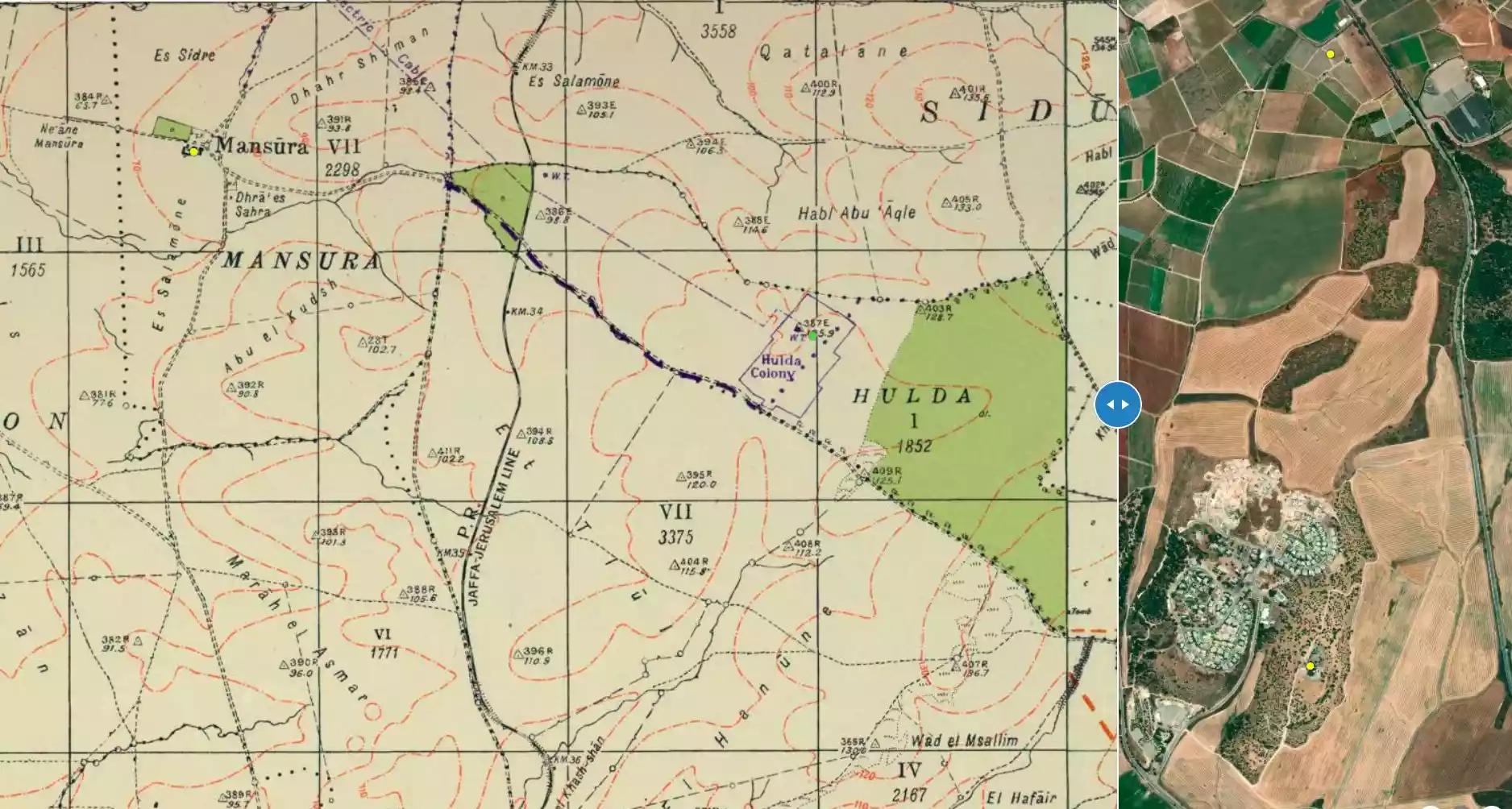
| Before & After Nakba, Click Map For Details |
||||||||||||||||
|
||||||||||||||||
| Map Location | See location #39 on the map View from satellite |
|||||||||||||||
| Military Operation | Operation Barak (lightening) | |||||||||||||||
| Attacking Units | Either Giv'ati Brigade or Har' el Brigade | |||||||||||||||
| Exodus Cause | Military assault by Zionist troops | |||||||||||||||
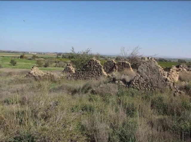
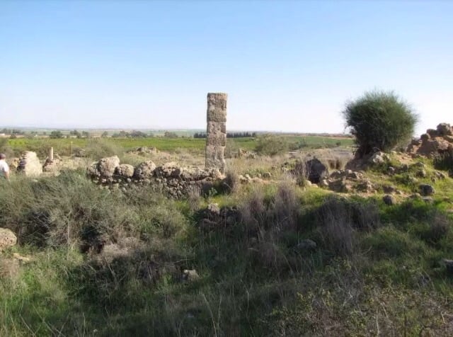
| Village Temains | al-Mansura was completely obliterated. | |||||||||||||||
| Ethnically Cleansing | al-Mansura inhabitants were completely ethnically cleansed. | |||||||||||||||
| Pre-Nakba Land Ownership |
**Town Lands' Demarcation Maps |
|||||||||||||||
| Land Usage As of 1945 |
|
|||||||||||||||
| Population |
|
|||||||||||||||
| Number of Houses |
|
|||||||||||||||
| Near By Towns |
||||||||||||||||
|
||||||||||||||||
| Schools | al-Mansura's students used to attend school in al-Ramla city and in the neighboring villages. | |||||||||||||||
| Exculsive Jewish Colonies That Usurped Village Lands |
No Israeli settlements on village lands. | |||||||||||||||
Village Before NakbaVillage Before 1948The village stood on a flat spot on the central coastal plain. A network of secondary roads intersected at al-Mansura, and one of them crossed through the village of 'Aqir and joined the highway leading to Ramla. The Jaffa-Jerusalem railway line ran 1 km east of it. Edward Robinson passed by the village in 1838; he described it as 'small.' In the late nineteenth century, al-Mansura was a moderate-sized village built of adobe brick. During the Mandate al-Mansura, classified as a hamlet by the Palestine Index Gazetteer, featured houses made either of adobe brick or cement that extended along the road to 'Aqir. Its entire population was Muslim, and the children attended school in Ramla and the neighboring villages. The villagers' main source of income was rainfed agriculture. They cultivated principally grain, as well as vegetables and fruits. Citrus and olive groves were concentrated on the east and west sides of the village. In 1944/45 a total of 2,113 dunums was allocated to cereals. Village Occupation and Ethnic CleaningAl-Mansura's location would place it naturally among the positions seized during Operation Barak (see al-Batani al-Gharbi, Gaza sub-district). However, Israeli historian Benny Morris indicates that it was attacked some time before this, on 20 April, at the same time as the nearby village of al-Mukhayzin. This suggests that it may have been captured in the course of one of the sub-operations (probably Operation Har' el) mounted in the Jerusalem corridor between mid-April and late June. Following on the heels of Operation Nachshon (see Bayt Naqquba, Jerusalem sub-district), these sub-operations were centered around the village of al-Latrun and aimed at securing control of the Jerusalem-Jaffa highway. AI-Mansura was almost certainly attacked by the Giv'ati Brigade, which acted in coordination with the Jerusalem-based Har' el Brigade during this period. But it may not have come under complete Israeli control until the subsequent operation.Zionists Colonies on Village LandsThere are no Israeli settlements on village land.Village TodayThe site is planted with sycamore trees and there are also cactuses growing on it. The surrounding land is cultivated by the settlers of Mazkeret Batya (134140); this settlement was founded in 1948 on land belonging to 'Aqir.SourceDr. Walid al-Khalidi, 1992: All That Remains. |
||||||||||||||||
| Related Maps | Town Lands' Demarcation Maps خرائط للقضاء توضح حدود القرى والاودية Town's map on MapQuest View from satellite Help us map this town at WikiMapia |
|||||||||||||||
| Related Links | Wikipedia's Page Google Search Google For Images Google For Videos |
|||||||||||||||
| More Information | في كتاب كي لا ننسى في كتاب بلادنا فلسطين المزيد من موقع هوية |
|||||||||||||||
- موقع القريه واثار بيوتها
Posted by abu raya - اثار بيوت القريه
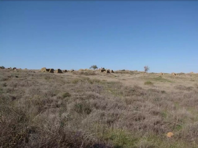
Posted by abu raya - اثار بيوت القريه
Posted by abu raya - خارطة تُظهِر الحدود والطرق بأنواعها والأماكن المقدسة والطبيعة الطوبغرافية من تلال وسهول ومنحدرات والتشكيلة الطبيعية للأرض وأنواع المزروعات. نُشرت الخريطة فترة الانتداب البريطاني، تم إضافة تعديلات عليها من قِبَل خدمة الخرائط والصور التابعة للقوات العسكرية الاسرائيلية فترة الأربعينيات.

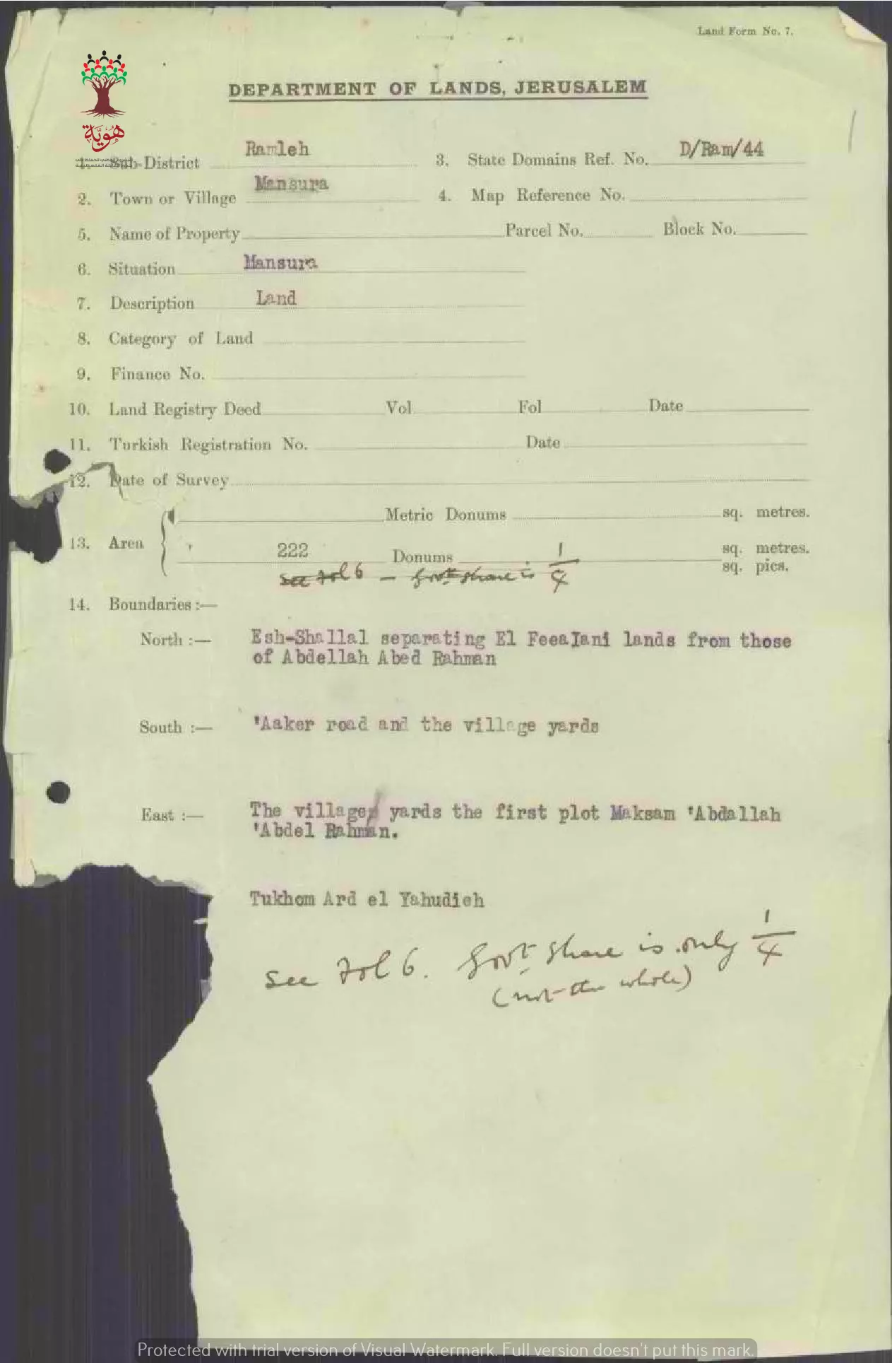
- مواصفات وحدود اﻷرض في قزازة-الرملة
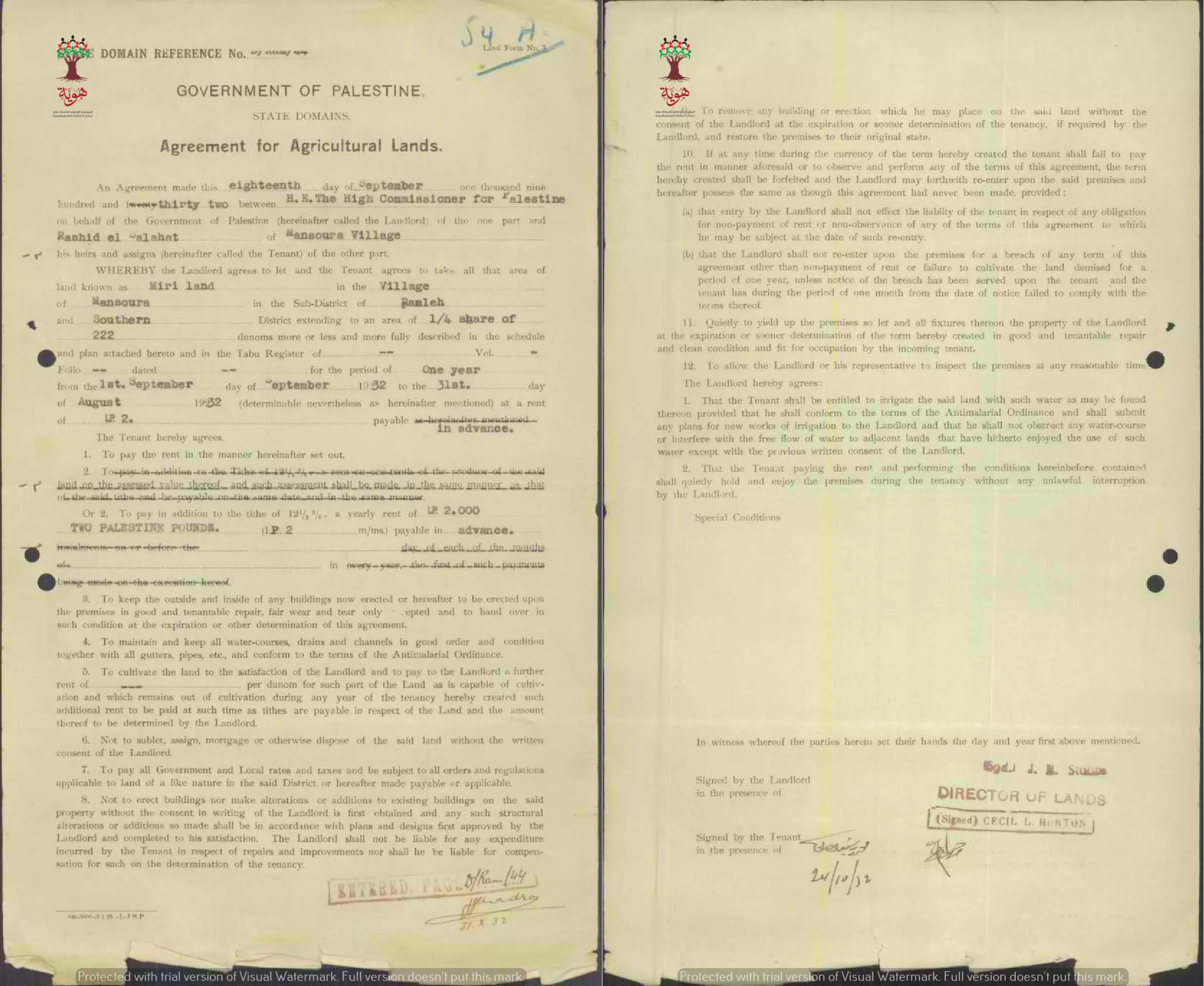
- عقد إيجار أرض المري في المنصورة بين الحكومة و رشيد صلاحات مقابل جنيهي فلسطيني سنويا -- 1932 -- أنقر الصورة لتكبيرها
-
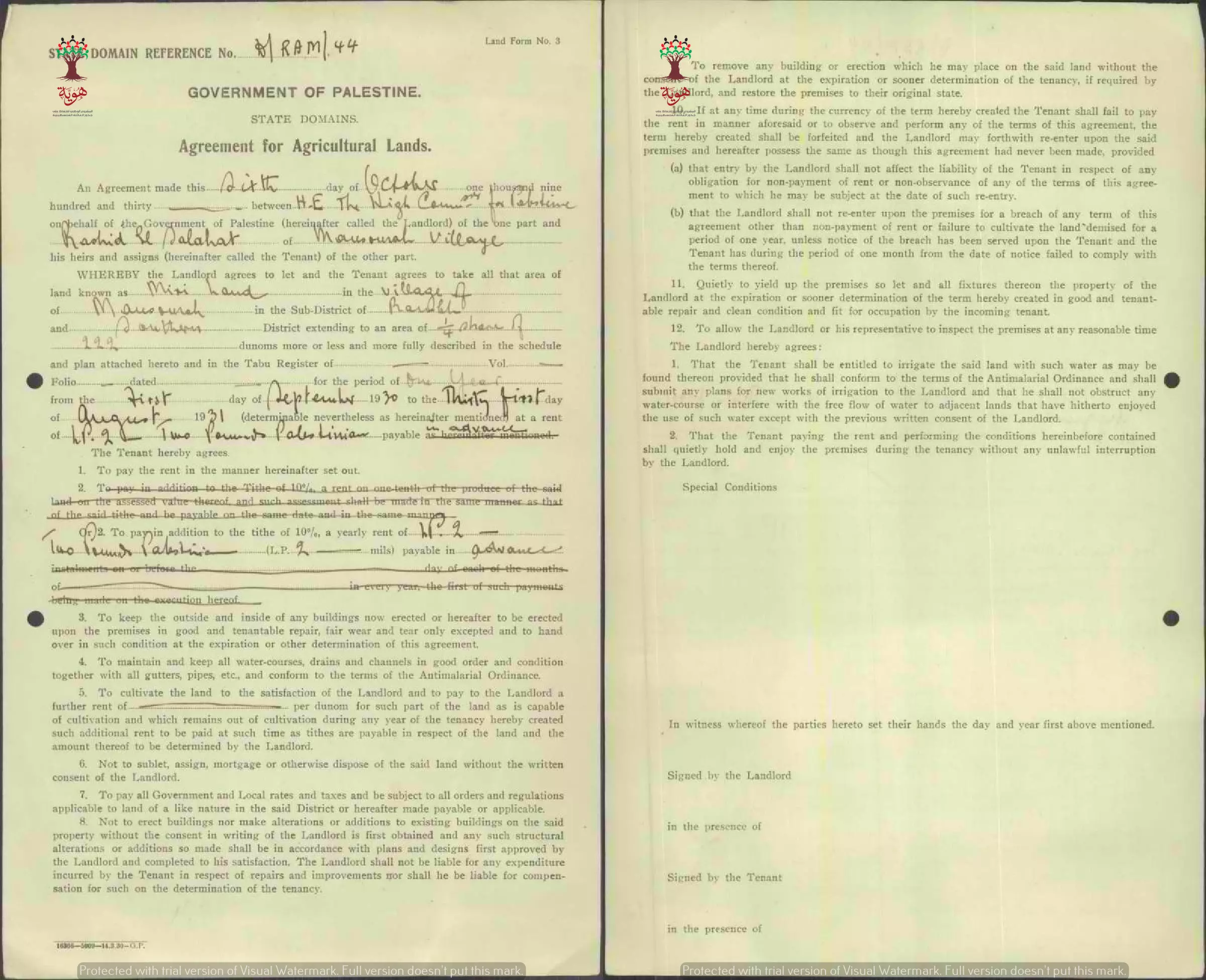
عقد إيجار أرض المري في المنصورة بين الحكومة و رشيد صلاحات مقابل جنيهي فلسطيني سنويا -- 1930 -- أنقر الصورة لتكبيرها
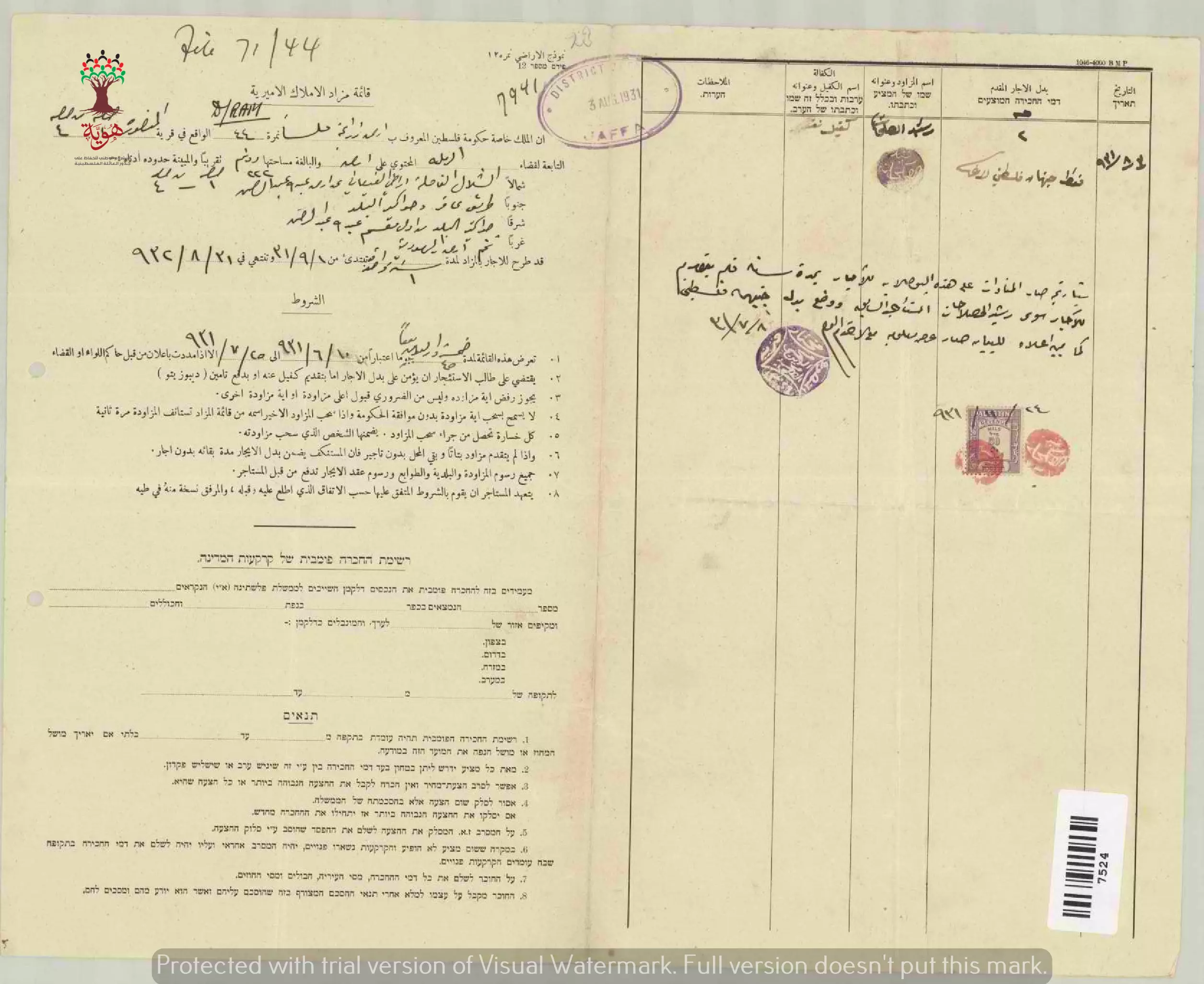
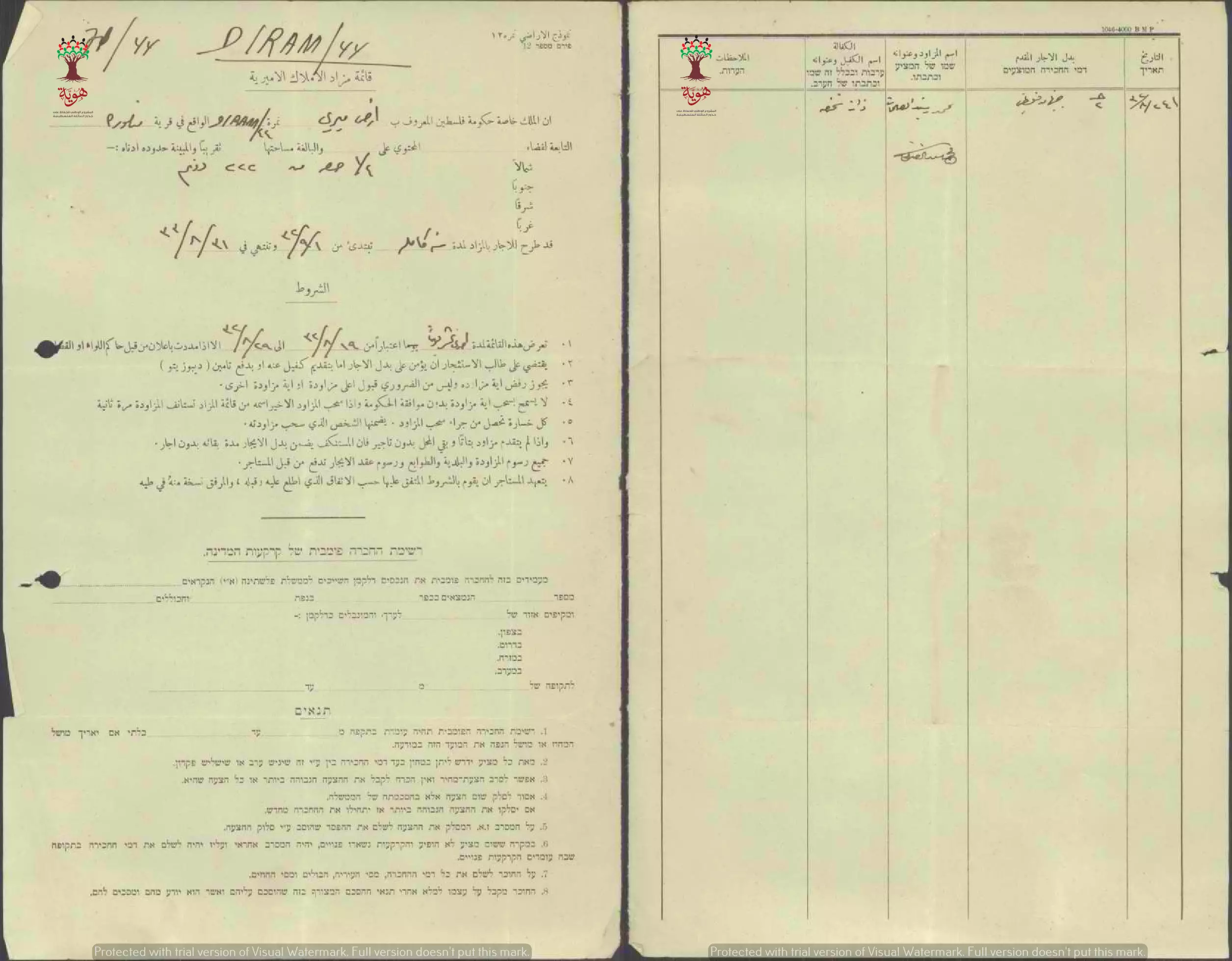
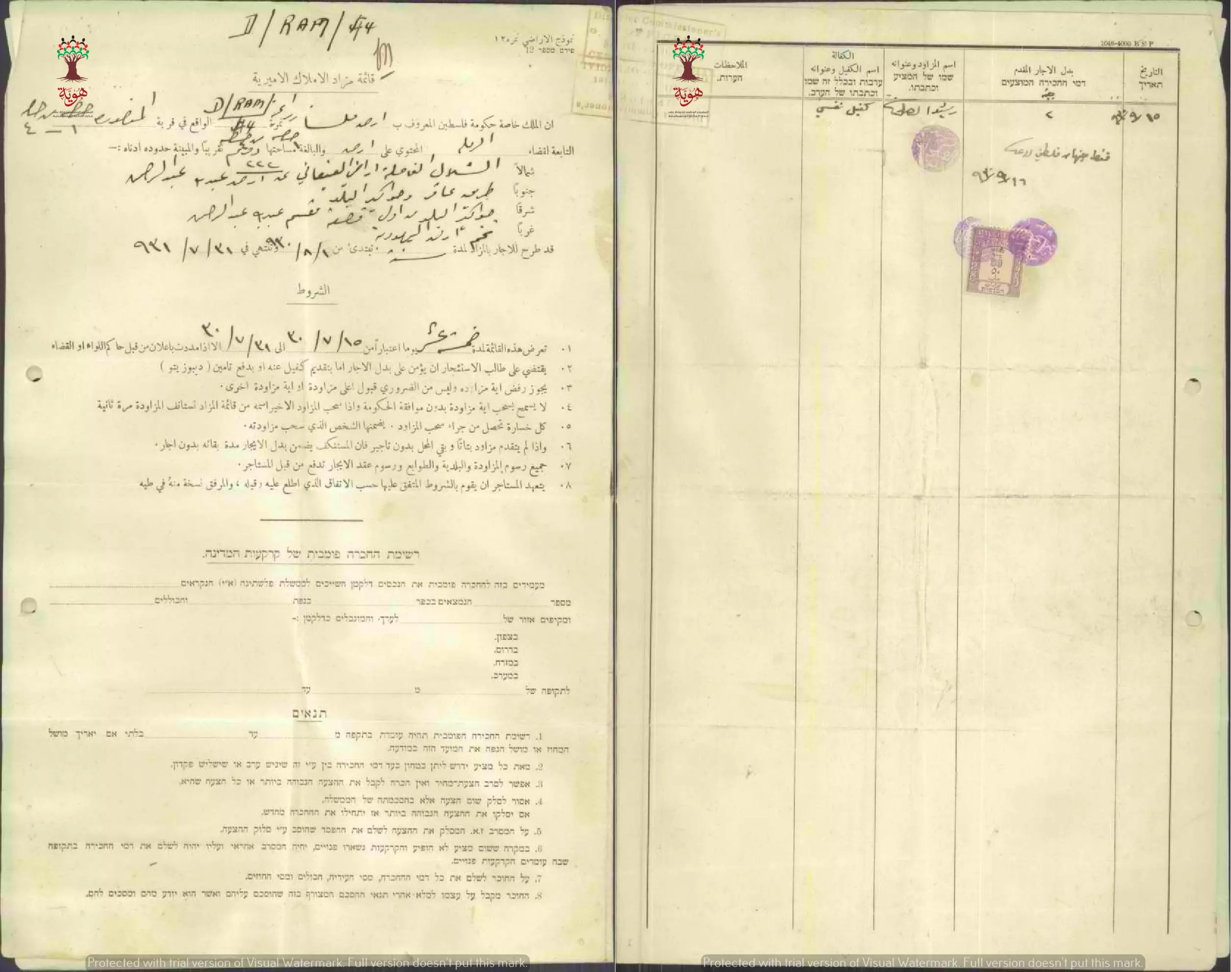
- قائمة مزاد الأملاك الأميرية في قرية المنصورة قضاء الرملة سنة 1931
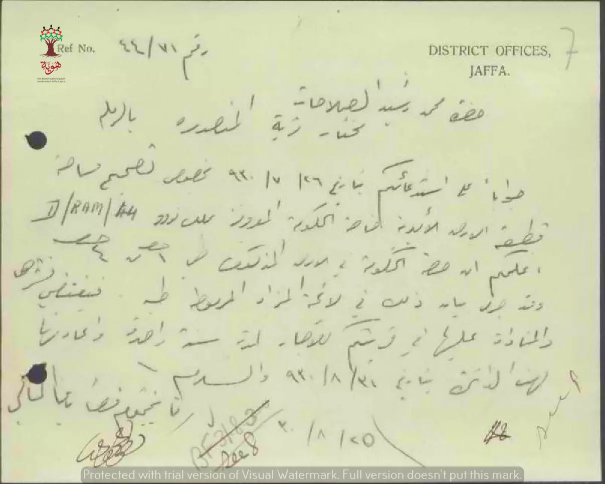
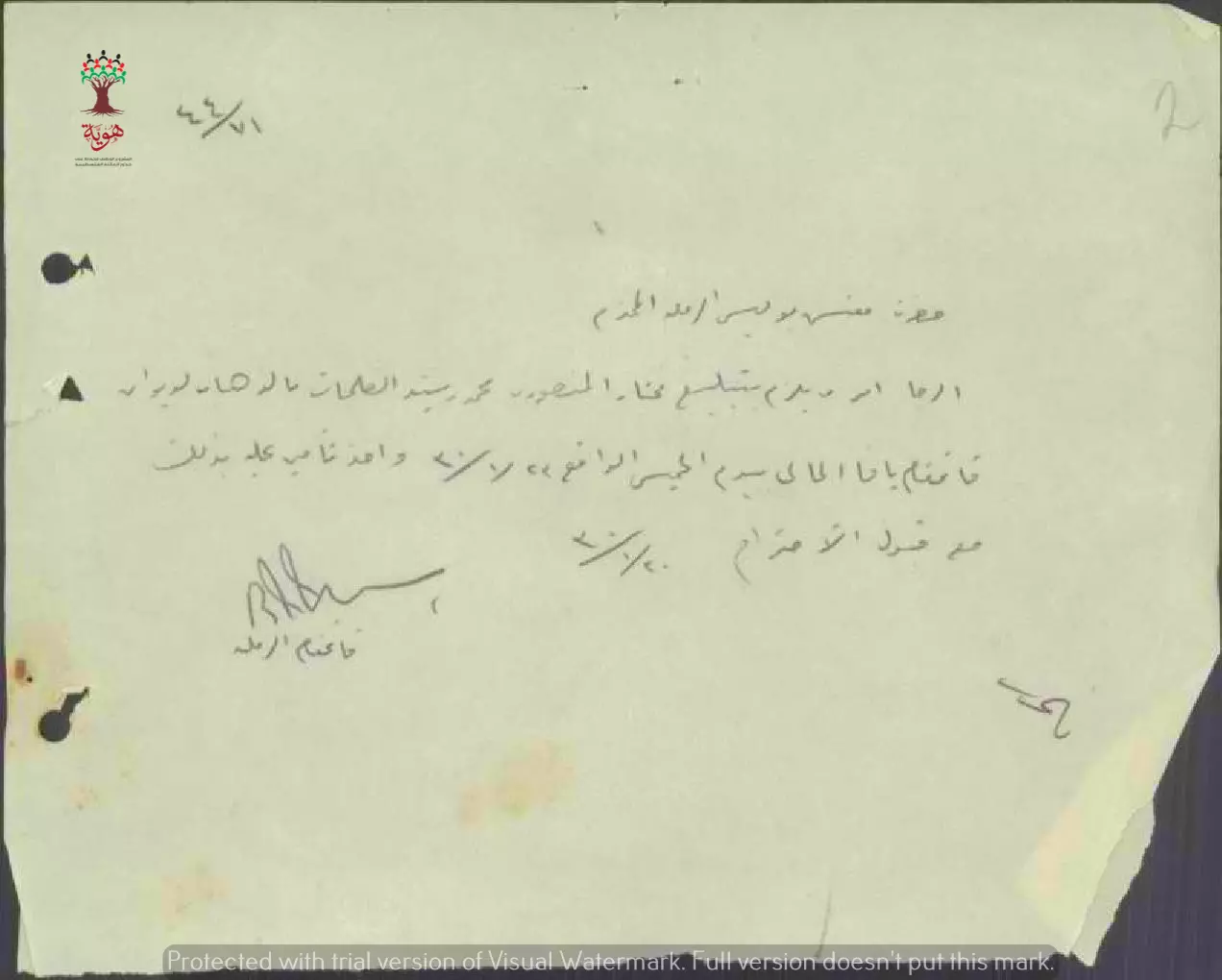
- رسالة من قائمقام الرملة الى مختار المنصورة محمد رشيد الصلاحات بخصوص تصحيح مساحة أرض الوقف الخيري وبالتالي يطلب منه نشر برنامج المزاد لتأجيرها لمدة سنة.
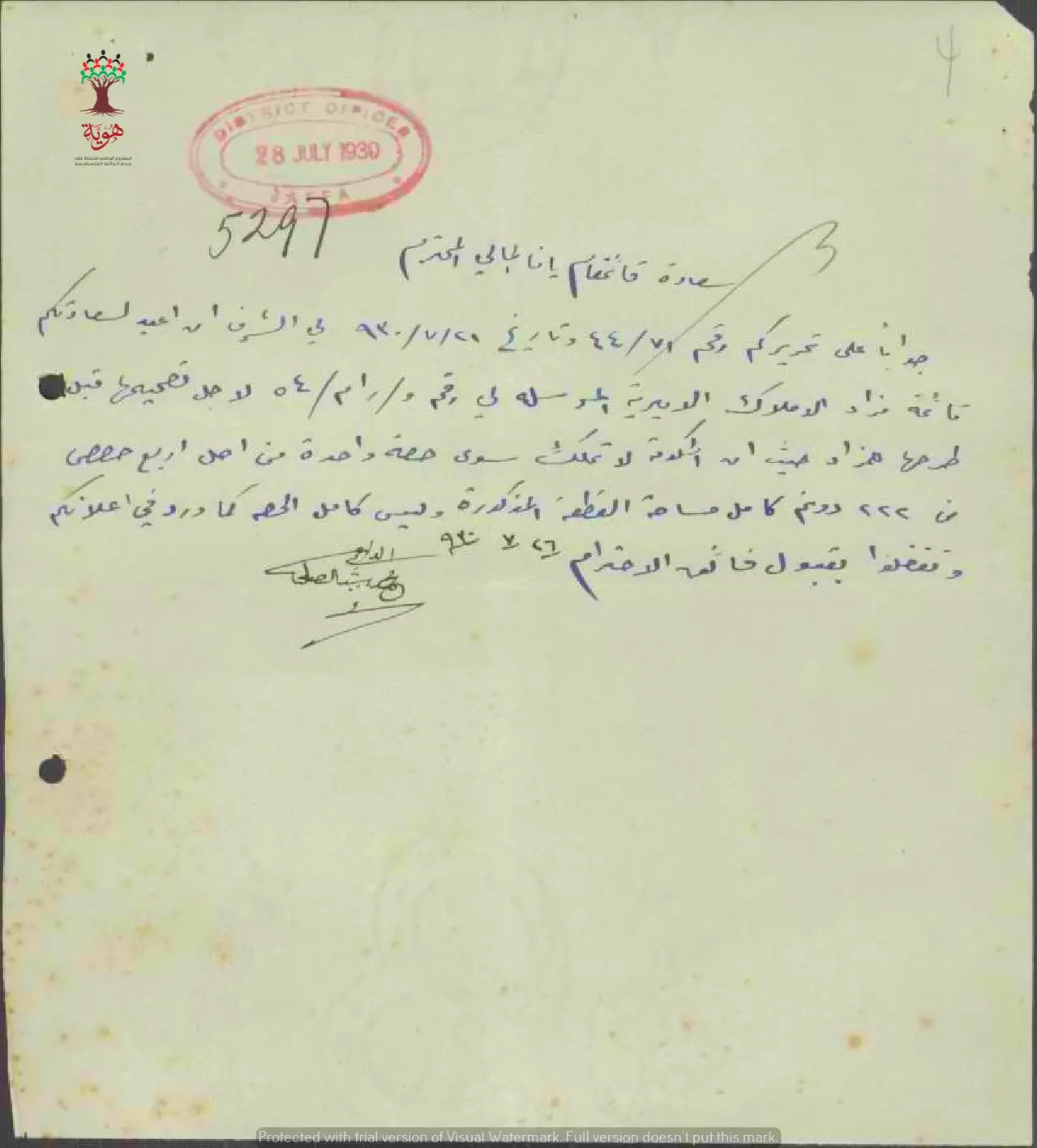
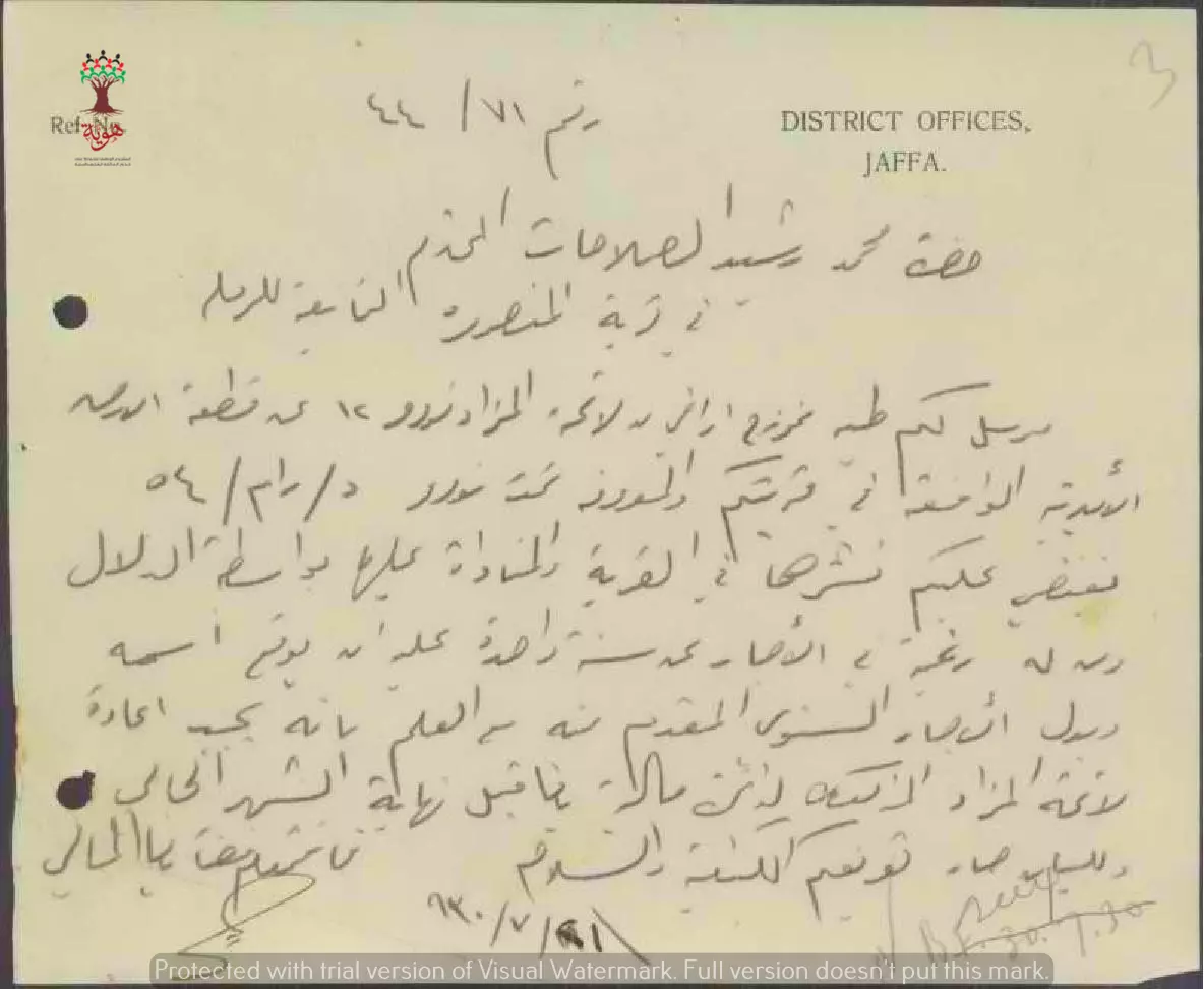
- رسالة من مختار المنصورة محمد الصلاحات الى قائمقام يافا بخصوص أرض الوقف المعروضة للمزاد بحيث تملك الحكومة 1/4 من الحصص فقط وليس الأرض كلها.
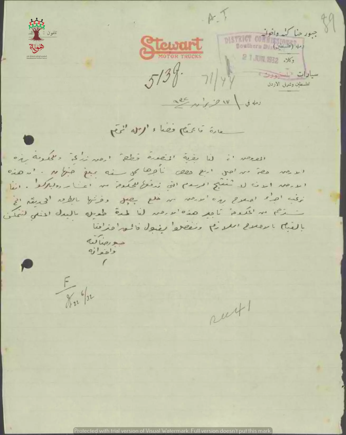
- رسالة من جبور حنا الكتة الى قائمقام قضاء الرملة بخصوص حصتهم في أرض الوقف في المنصورة حيث يملكون 3 حصص من أصل أربعة في هذه الأرض وبأنهم ينوون استصلاحها وزرعها ولذلك يطلبون باستئجار حصة الحكومة منها--17-06-1932
-
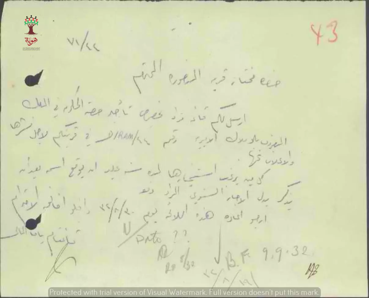
رسالة من قائمقام الرملة الى مختار المنصورة محمد رشيد الصلاحات بخصوص مزاد أرض الوقف الخيري --19-08-1932
- قائمة مزاد الأملاك الأميرية في قرية المنصورة قضاء الرملة سنة 1933
--
من تاريخ 1-9-1932 لتاريخ 31-8-1933-- أنقر الصورة لتكبيرها
- رسالة من قائمقام الرملة الى مفتش بوليس الرملة يستدعي فيها مختار المنصورة محمد رشيد الصلاحات --20-01-1930
-
رسالة من قائمقام الرملة الى مختار المنصورة محمد رشيد الصلاحات بخصوص مزاد أرض الوقف الخيري ويطلب منه نشر نموذج الأرض المعروضة للمزاد لتسجيل أسماء المشاركين بواسطة الدلال.--21-07-1930
-
قائمة مزاد الأملاك الأميرية في قرية المنصورة قضاء الرملة--15-09-1930
Want to browse more? 80,000 pictures were grouped in these gallaries:
- مواصفات وحدود اﻷرض في قزازة-الرملة
- عقد إيجار أرض المري في المنصورة بين الحكومة و رشيد صلاحات مقابل جنيهي فلسطيني سنويا -- 1932 -- أنقر الصورة لتكبيرها
-
عقد إيجار أرض المري في المنصورة بين الحكومة و رشيد صلاحات مقابل جنيهي فلسطيني سنويا -- 1930 -- أنقر الصورة لتكبيرها
- قائمة مزاد الأملاك الأميرية في قرية المنصورة قضاء الرملة سنة 1931
-
قائمة مزاد الأملاك الأميرية في قرية المنصورة قضاء الرملة--15-09-1930
| Display Name | Clan/Hamolah | Country of Residence |
| خالد الصلاحات | - | عمان, الأردن |
| بسمه الورد | السطري | عمان, الاردن |
| اسامة المصراطي | المصراطي | عمان |
| Murad Kahlifah | Khalifah | Abu Dhabi , Abu Dhabi |
| mohammad | herborn | jordan, jordan |
No links have been shared yet, be free to the first to share the first link.
 Fake Valor: Why Did Zionist Jews Hoist Nazis Flag on Their Ships in the 1930s?
What is new?
-
Facts About Oct. 7th Gaza Raid
-
Remined Us Please: Who Did Rape Whom? Was it Palestinians who raped Israelis? Or, was the other way around? You'll be the judge
-
When Prof. Edward Said was invited to debate Bibi Netanyahu in the 1980s, watch what happened!
-
Ezra Klein of the NY Times on the "Jewish Race".
-
Abusing Blood Libel!
-
How and why Israeli Jewry has become the most hated cult?
-
Did Israeli Soldiers Activate The Hannibal Direective On Oct. 7th? You Be The Judge
-
Zionist FAQ: Isn't it true that Palestinians don't want peace? Palestinians never accepted the two-state solution
- Facts about Haavara (Transfer) Agreement between Ben-Gurion & Hitler
-
Haavara FAQs: Why Did Zionist Jews Hoist Nazis' Flags on Their Ships in the 1930s?
- Haavara FAQs: When Chaim Weizmann met FDR in mid-1943, why was he silent about rescuing European Jewry?
-
Dear ChatGPT: How did Palestinians resist Napoleon's invasion of their country in 1799?
-
Dear ChatGPT: Gaza had a vibrant Jewish community in the mid-17th century. What happened to them?
-
Dear ChatGPT: Why did the Jewish Agency suppress news of the Holocaust during WWII?
-
Video Playlist: Jews share their DNA tests to end the conflict for good.
-
A Tale of Two Conflicts: Examining the Definition of Genocide
-
Prof. Abraham Polak And The Suppressed History of the Khazars and European Jewry
-
How Ronald Reagan would have framed the genocide in Gaza if he were still alive?
-
Haavara FAQs: Let us do the math: how many German Jews did The Haavara Agreement save?
-
Zionist FAQs: The Hebron Massacre of 1929, "clearly proves" that Palestinians are antisemitic, how could you deny it?
-
Zionist FAQs: Why Anti-Zionist Is Not Antisemitism?
-
Zionist FAQs: Isn't it true that the KGB created Palestinian Nationalism in the early 1960s?
- Zionist FAQs: Muslims are killing Muslims all the time; why are Israeli Jews being singled out in the media?
- Zionist FAQs: How is Israel an apartheid state when 20% of its citizens are Arabs who enjoy full rights?
-
Haavara FAQs: Why Did Dorothy Thompson Flip From A Zionist Advocate to A Silenced Dissenter?
-
Haavara FAQs: Analysis of Herzl's Uganda Scheme and how it could have saved millions of Jews.
-
Haavara FAQs: Why did Hayim Greenberg describe American Jewry as "morally bankrupt" in early 1943?
-
Haavara FAQs: What if the Evian Conference was a resounding success? What would have been the impact of saving European Jewry on Zionism?
- Haavara FAQs: What if the six million were saved, how that would have impacted the Zionist project?
-
Haavara FAQs: How did Zionist leaders react when Europe's Jews lingered in the DP camps after WWII ended?
-
Why does the American Jewish community repeat lies that David Ben-Gurion had debunked before he died?
-
Who has the power to rename the Tatar/Khazar Gene Marker to Jewish IV?
-
Zionist FAQs: Why won't Egypt, Syria, and Jordan take their people back? Jews are indigenous to Palestine, and Arabs immigrated after Jews developed the country. Arabs should leave.
-
Haavara FAQs: Did Hitler and the Nazis conflate between Judaism and Zionist? If that wasn't case, then why?
-
Haavara FAQs: Winston Churchill and antisemitism, a collection of articles written Churchill.
-
Haavara FAQs: Broken by country, how many Jews survived vs. killed during the Holocaust?
-
Haavara FAQs: Why did European Jews vote with their feet and to immigrated to the Americas, not Palestine, after WWII?
-
Watch this American Jewish Girl describing Israeli Jews' cognitive dissonance like no other in under two minutes
-
Haavara FAQs: When the Nazis went out of their way to hide the Holocaust, Israeli Jews did the exact opposite by broadcasting their genocide of Gazans. But why?
-
Haavara FAQs: How Zionist Jews went out of their to show their appreciation to Nazism and Fascism?
- Haavara FAQs: Why Zionist leaders were against bombing the death camps & the Railroads leading to them?
-
Haavara FAQs: Hitler's message to the British and American people: If Jews are such noble citizens and you care about them, how come you're not letting them in? I will gladly ship them to you at my expense, even on luxury liners!
-
A shortlist of Zionist and Israeli false flag operations in the name Jews.
-
The Most Moral Army
- The Land of Kapos (Israel): Where the brave are boycotted and Kapos walk free.
- Why did early Zionists often named their communal enterprises "colonial"?
- Zionist Relations with Nazi Germany by Faris Glubb
-
Two NY Times advertisements by Zionists in the early 1943 that exposes Zionists' treason at the height of the calamity
- Facts Not Lies about the Palestinian-Israeli Conflict.
- Site's pictures have been categorized
- Campgain Against Lice
- A Survey of Palestine, the official source about Palestine before Nakba produced by the British Mandate; over 1200 pages.
- Satellite View & Google Earth: Over 6,000 placemarks identifying all destroyed towns, W. Bank & Gaza Strip Towns, & refugee camps.
- PalestineRemembered.com and its Nakba Oral History Project were featured on al-Jazeera Satellite TV.
- Nakba Oral History Video Podcast:
 Over 700 Oral History interviews (including 3,500+ hours of recording) can be viewed online.
 - Palestine Village Statistics Project
- Gaza Jail Break
- النسخة العربية للموقع الان متوفرة
- Videos: Documenting the destroyed villages in video: Tracing all that remains since Nakba.
- Videos: Responding to Zionist Propaganda
- Interview: The ethnic cleansing of Palestine: George Galloway interviews Israeli Historian Ilan Pappe.
- For Palestinians, memory matters. It provides a blueprint for their future By George Bisharat.
- Zionist FAQ now available in Hebrew שאלות שציונים שואלים, עכשיו בעברית
- Video: The Stephen Walt and John Mearsheimer report on the influence of the Israel Lobby on U.S. Foreign Policy
- The Palestinian-Israeli conflict for beginners
