| PalestineRemembered | About Us | Oral History | العربية | |
| Pictures | Zionist FAQs | Haavara | Maps | |
| Search |
| Camps |
| Districts |
| Acre |
| Baysan |
| Beersheba |
| Bethlehem |
| Gaza |
| Haifa |
| Hebron |
| Jaffa |
| Jericho |
| Jerusalem |
| Jinin |
| Nablus |
| Nazareth |
| Ramallah |
| al-Ramla |
| Safad |
| Tiberias |
| Tulkarm |
| Donate |
| Contact |
| Profile |
| Videos |
Welcome To Hamama - حمامه (חמאמה)
|
District of Gaza
Ethnically cleansed days ago |
العربية Google Earth |
 |
Gallery (16) |
- Statistics & Facts
-
Before & After

- Satellite View
- Articles 1
- Pictures 16
- Aerial Views 1
- Oral History 3
- Members 60
- All That Remains
- Wikipedia
- Videos 2
- Guest Book 15
- Links 2
| Statistic & Fact | Value | |||||||||||||||||||||
| Occupation Date | November 4, 1948 | |||||||||||||||||||||
| Distance From District | 24 (km) North East of Gaza | |||||||||||||||||||||
| Elevation | 25 (meters) | |||||||||||||||||||||
| Before & After Nakba, Click Map For Details |
||||||||||||||||||||||
|
||||||||||||||||||||||
| Pre-Nakba Aerial View |
||||||||||||||||||||||
|
||||||||||||||||||||||
| Map Location | See location #13 on the map View from satellite |
|||||||||||||||||||||
| Military Operation | Third stage of the Israeli army's Operation Yo'av. | |||||||||||||||||||||
| Attacking Units | Giva'ti Brigade | |||||||||||||||||||||
| Defenders | Egyptian Army | |||||||||||||||||||||
| Exodus Cause | Military assault by Zionist troops | |||||||||||||||||||||
| Village Temains | The village was completely obliterated. | |||||||||||||||||||||
| Ethnically Cleansing | Hamama inhabitants were completely ethnically cleansed. | |||||||||||||||||||||
| Pre-Nakba Land Ownership |
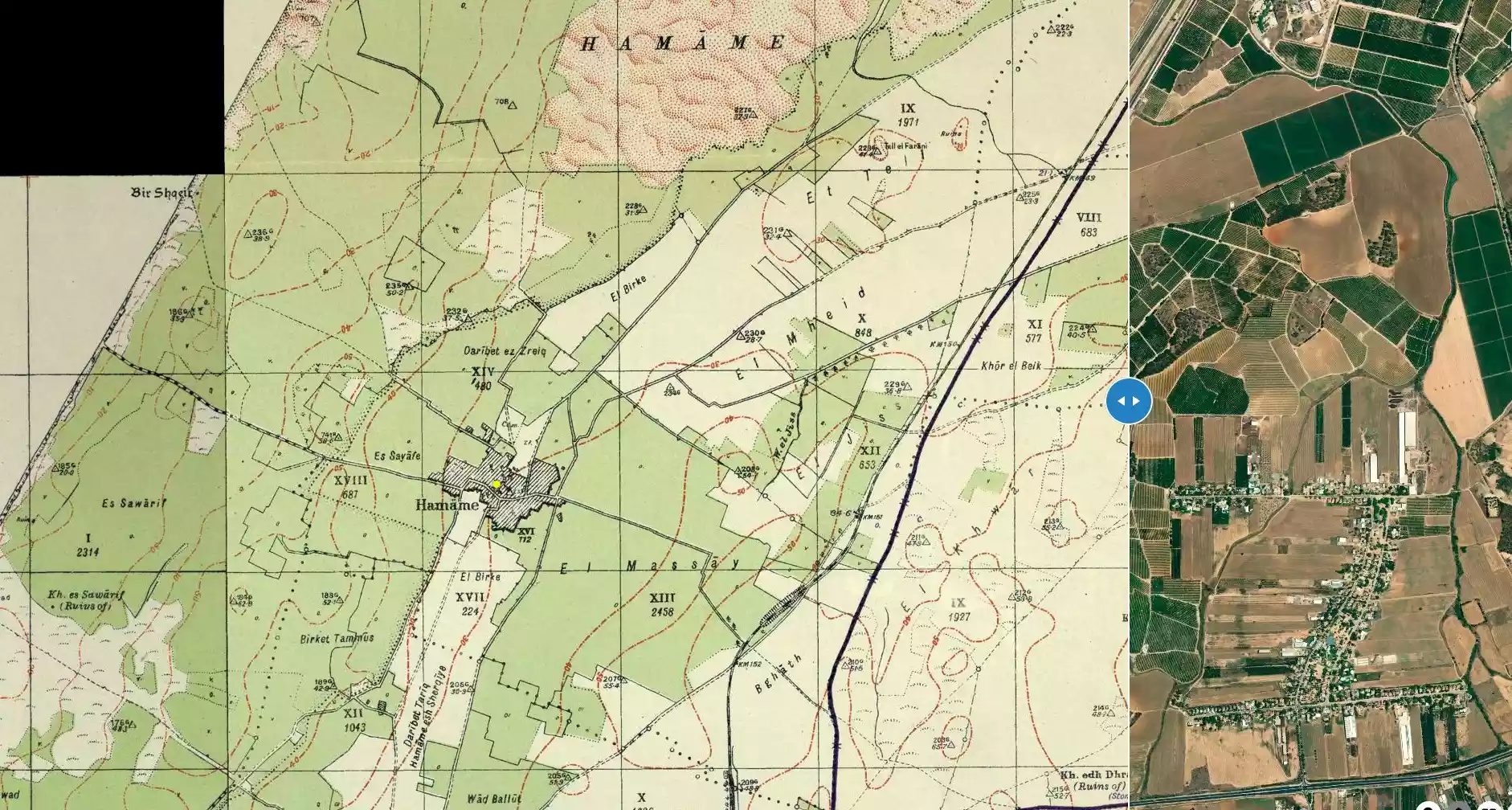
**Town Lands' Demarcation Maps |
|||||||||||||||||||||
| Land Usage As of 1945 |
|
|||||||||||||||||||||
| Population |
|
|||||||||||||||||||||
| Number of Houses |
|
|||||||||||||||||||||
| Near By Towns |
||||||||||||||||||||||
|
||||||||||||||||||||||
| Town's Name Through History | During Byzantine period Hamama was known by Peleia. | |||||||||||||||||||||
| Schools | Hamama had two elementary schools:- the 1st was a school for boys which was founded in 1921, and in 1945 it had an enrollment of 338 boys; and the 2nd school was for girls which was founded in 1946 and it had enrollment of 46 girls. | |||||||||||||||||||||
| Local Council | The village had council which administered its local affairs. | |||||||||||||||||||||
| Places of Warship | One mosque | |||||||||||||||||||||
| Archeological Sites | The village contained Khirbat Khawr al-Bayk and Khirbat Shaykh 'Awad. | |||||||||||||||||||||
| Exculsive Jewish Colonies Who Usurped Village Lands |
Nitzanim, Nitzanim-Kefar ha-No'ar, Beyt 'Ezra, & Eshkolot | |||||||||||||||||||||
| Featured Video | ||||||||||||||||||||||
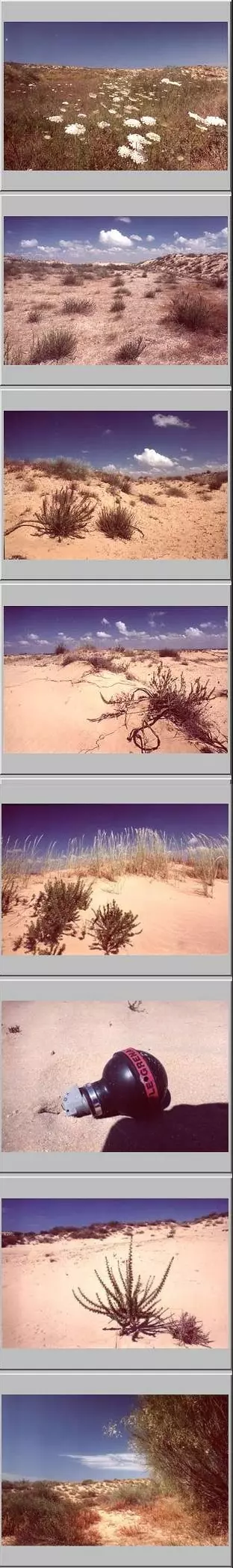
Village Before NakbaThe village stood on flat land on the coastal plain, about 2 km from the seashore, bordered by two long sand dunes on the east and west sides. The coastal highway and railway line ran a short distance to the east of it. Hamama (which means 'dove' in Arabic) was built on the site of Tall Mishqafa, identified as Peleia (also meaning 'dove') in an early fifth-century Byzantine source. It was near the site of a battle between the Crusaders and Muslims in 1099 that ended in the triumph of the former. The Mamluk sultan, al-Ashraf Barsbay, was reported to have passed through it in 1432. Hamama was also said to have been the birthplace of Ahmad al-Shafi'i (1406–1465), a renowned Muslim scholar, teacher, and preacher at the al-Aqsa mosque in Jerusalem. In 1596, Hamama was a village in the nahiya of Gaza (liwa' of Gaza), with a population of 462. It paid taxes on goats and beehives. The Sufi traveler al-Bakri al-Siddiqi, who passed through the region in the mid-eighteenth century, reported that he visited the village of Hamama after he left al-Jura.Most of the village residents were Muslims. They built their houses along the roads connecting Hamama to other villages, which resulted in a star-shaped pattern of construction.' Its longest extensions were to the north and northwest. The village had a mosque and two elementary schools: one for boys, opened in 1921, and another for girls, opened in 1946. In 1946, 338 students were enrolled in the boys' school and 46 in the girls'. A village council administered local affairs. The villagers cultivated a wide variety of crops: grain, citrus, apricots, almonds, figs, olives, watermelons, and cantaloupes. Because of sand dunes, particularly on the north side, the community planted trees on parts of the land to prevent soil erosion and sand encroachment. In 1944/45 a total of 961 dunums was devoted to citrus and bananas and 20,990 dunums were planted in cereals; 4,325 dunums were irrigated or used for orchards. In addition to agriculture, the inhabitants engaged in fishing. The area around Hamama contained numerous archaeological sites with visible ruins. These included Khirbat Khawr al-Bayk and Shaykh Awad. Village Occupation and Ethnic CleaningReports in the Palestinian newspaper Filastin show that Hamama was first drawn into the war by a number of hit-and-run strikes beginning in January 1948. On 22 January, a group of workers from the village laboring in the fields between Hamama and Isdud were attacked by Jewish settlers from nearby Nitzanim. The attack left fifteen of the Arab workers wounded, two seriously, according to the report. Two days later, another unit from the settlement opened fire on villagers from Hamama, this time killing one and wounding another. The following month, on 17 February, a group of villagers waiting for the bus on the main road between Hamama and Isdud were fired upon and two were wounded. The paper again wrote that the attackers withdrew to Nitzanim.Israeli historian Benny Morris writes that the village was occupied in the third stage of the Israeli army's Operation Yoav , on 28 October. By the beginning of the operation, Hamama had a large refugee population, created by the military offensives launched during the previous months. Nearby Isdud (5 km to the north) came under naval and aerial attack at the beginning of Operation Yoav and fell into Israeli hands in the third stage of the operation. The New York Times stated on 18 October that Israeli air force bombers had flown 'practically unhindered' to their targets for three nights in succession and that these targets included Isdud. The bulk of the remaining population fled with retreating Egyptian columns before the Israeli entry on 28 October. In the third stage of Operation Yoav, the successes of the previous stages were used to occupy more territory. Al-Qubayba and Hamama were captured around 28 October 1948. The third stage was marked by 'panic flight' and 'some expulsions,' according to Morris. When the Yiftach Brigade entered Hamama, the unit's intelligence report stated that it was 'full of refugees' from Isdud and elsewhere. Morris adds: 'The remaining Hamama population and the refugees in the town either fled southwards after the [Israeli army] conquest or were urged or ordered to do so by troops.' One of the larger, little-known massacres of the war was committed on 29 October 1948 during this stage at al-Dawayima ( 25 km to the east). Morris claims that it precipitated a massive flight of people from the area. Zionists Colonies on Village LandsTwo settlements were established in the 1940s northeast of the village on village lands, although not close to the site: Nitzanim, in 1943, and Nitzanim–Kefar ha-No'ar in 1949. Beyt Ezra was built on village land in 1950. A farm called Eshkolot was established on village land in the 1950s.Village TodayNo traces of village houses or landmarks remain. The site is overgrown with wild vegetation, including tall grasses, weeds, and bushes. It also contains cactuses. The surrounding land is unused.SourceDr. Walid al-Khalidi, 1992: All That Remains. |
||||||||||||||||||||||
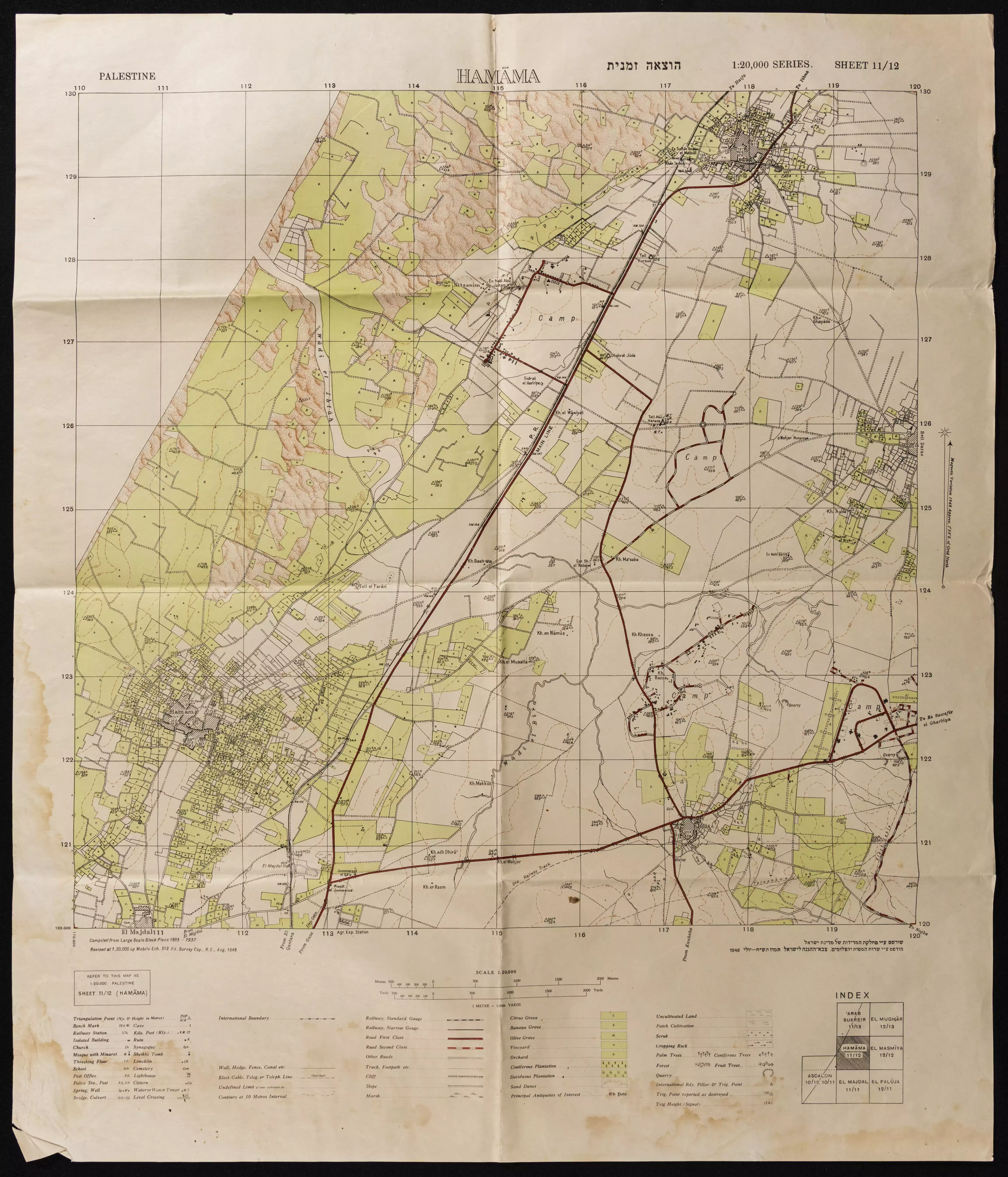
| Related Maps | Town Lands' Demarcation Maps خرائط للقضاء توضح حدود القرى والاودية Town's map on MapQuest View from satellite Help us map this town at WikiMapia |
|||||||||||||||||||||
| Related Links | Wikipedia's Page Google Search Google For Images Google For Videos |
|||||||||||||||||||||
| More Information | في كتاب كي لا ننسى في كتاب بلادنا فلسطين المزيد من موقع هوية |
|||||||||||||||||||||
- Remains Of Village Cemetery in 1987
Scanned from "All That Remains" by Dr. Walid Khalidi 6 - Remains Of Village Cemetery 2 in 1987
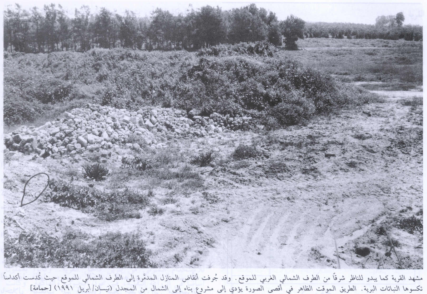
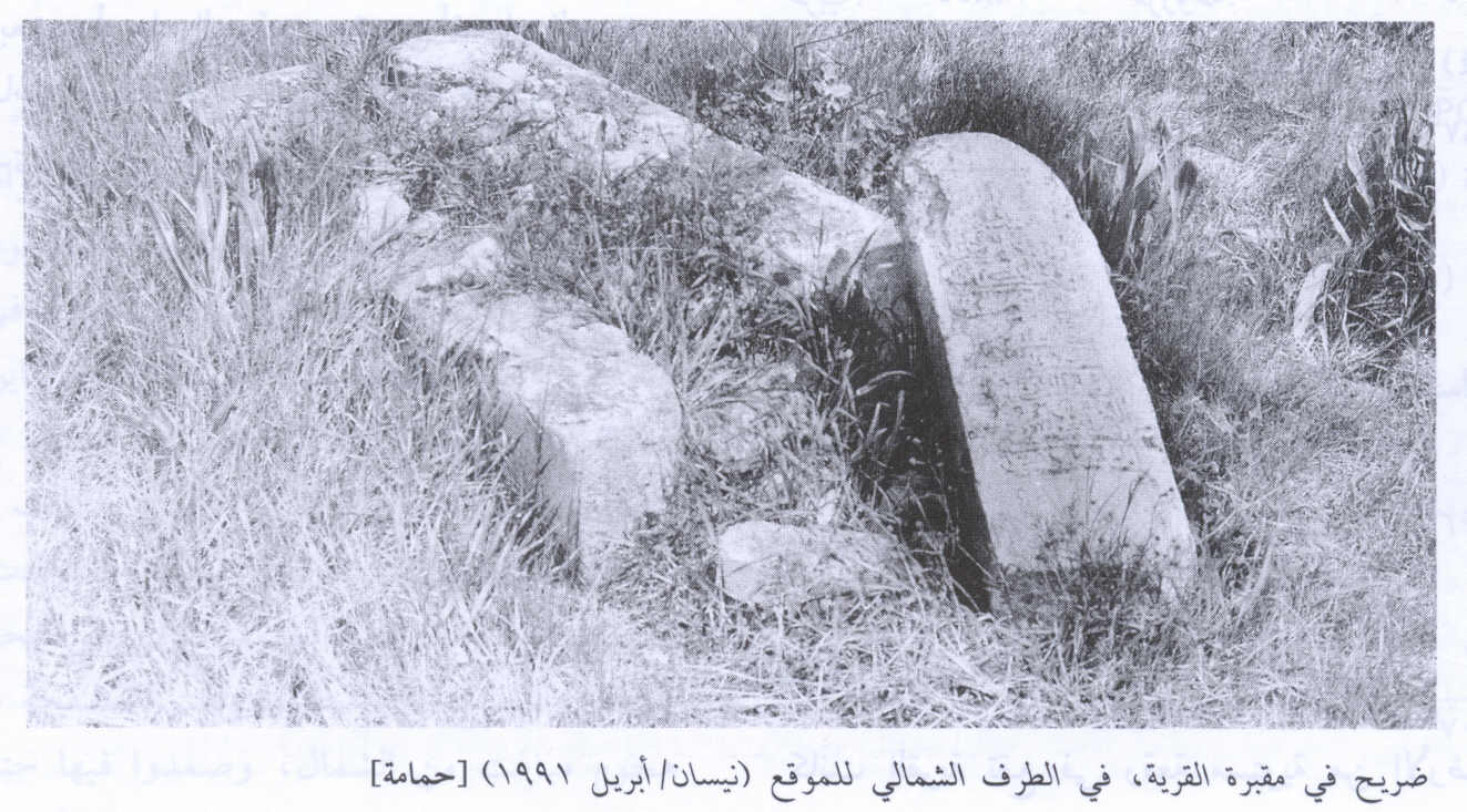
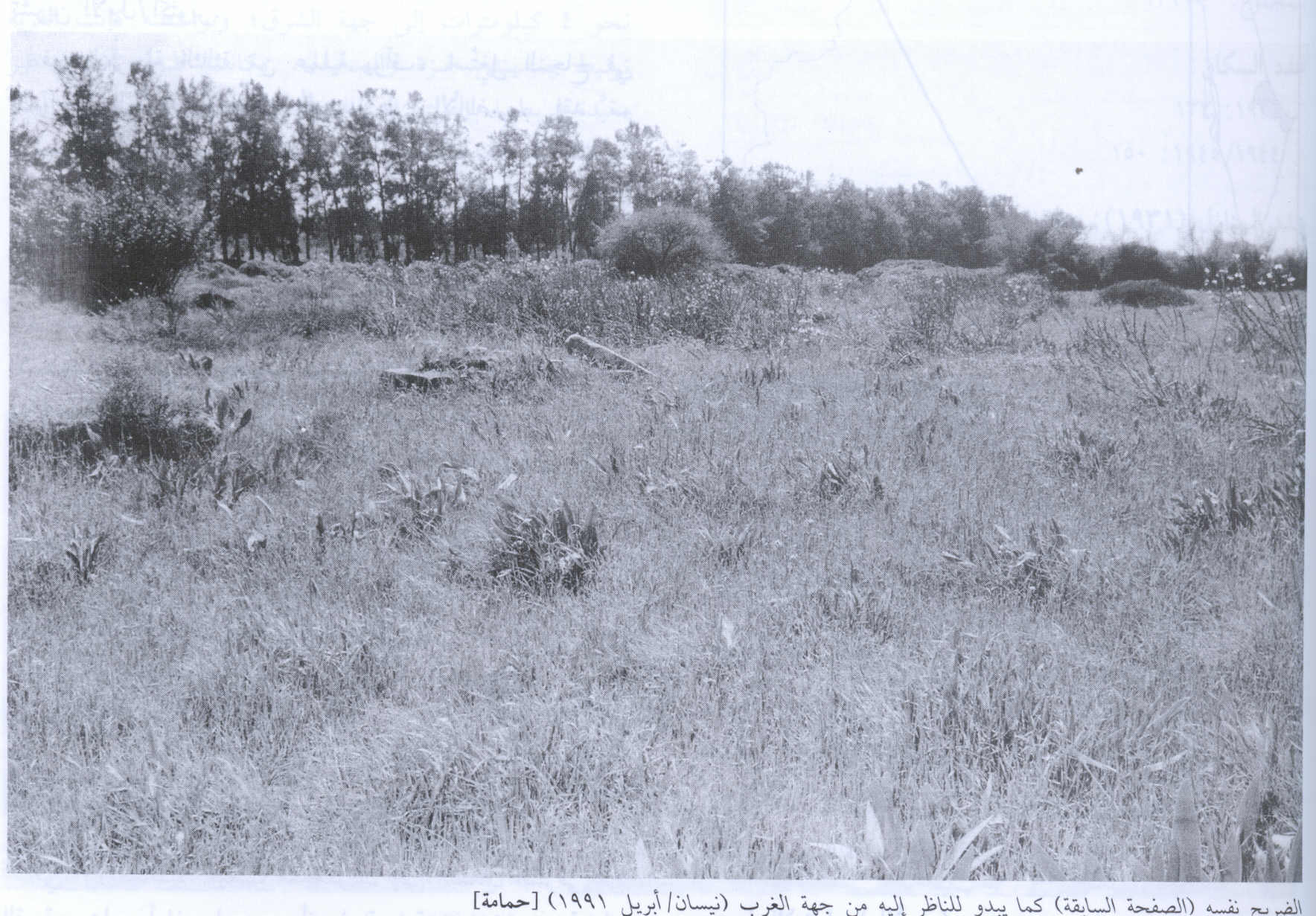
Scanned from "All That Remains" by Dr. Walid Khalidi 1 - Remains Of Village Rubble in 1991
Scanned from "All That Remains" by Dr. Walid Khalidi - Several pictures of Hamama concatenated together, 2002
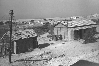
Posted by gfgtt 1 - early settlement of NITZANIM in hamama during 1948
Posted by Obai Radwan 6 - general view of hamama

Posted by Obai Radwan - general view of hamama (2)

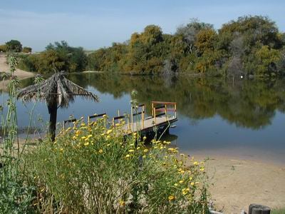
Posted by Obai Radwan 1 - Hamama's Lake (1)
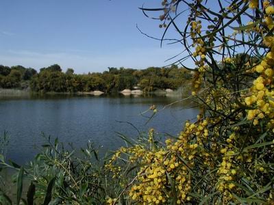
Posted by Obai Radwan - Hamama's Lake (2)
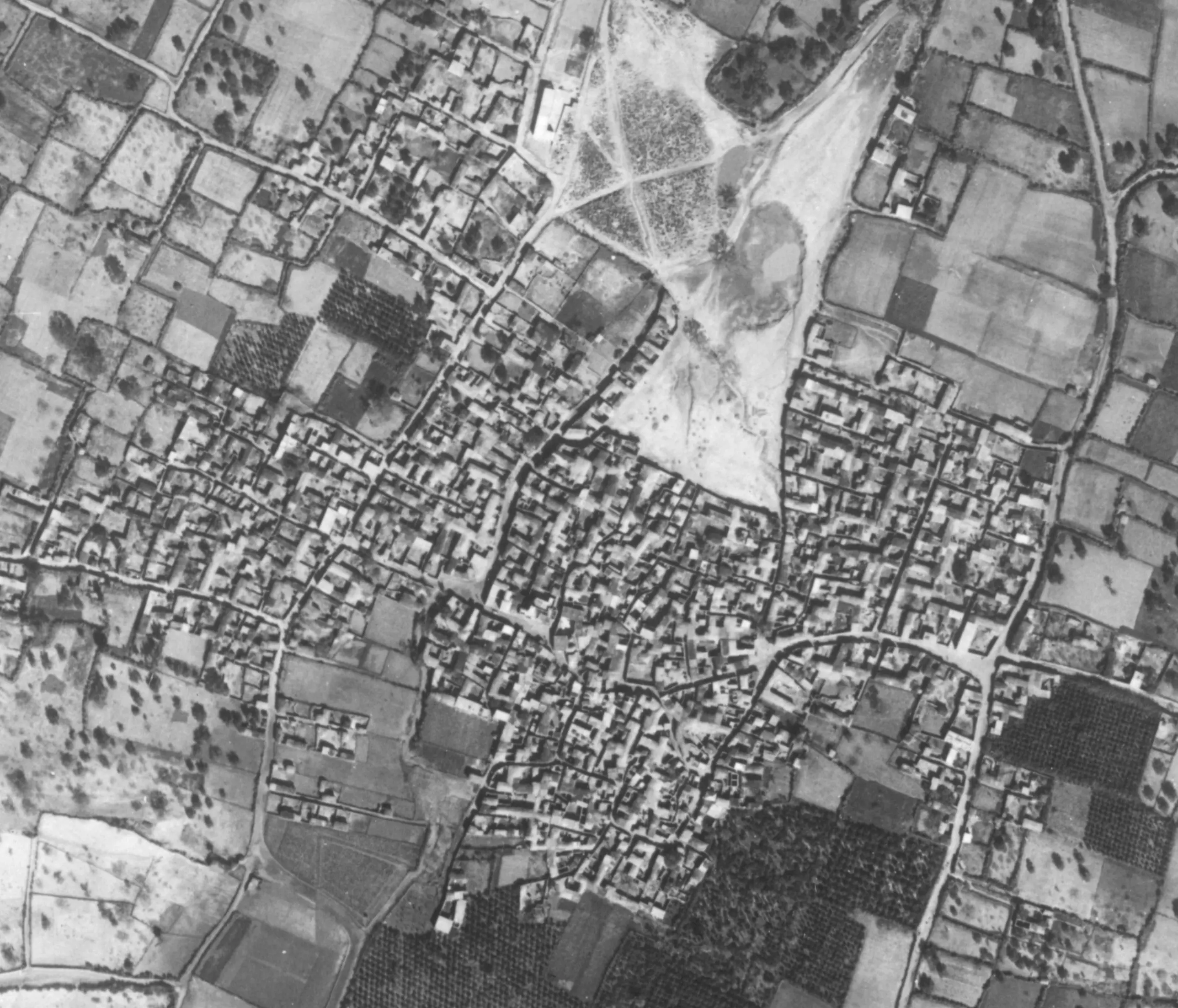
Posted by Obai Radwan 1 - Aerial photo of Hamama from January 1945
Posted by Eitan Bronstein Aparicio - لح عشائري وجهه عارف العارف -هده للأخوين د.عادل عوض الله وطلعت شاكر -ابو عمر الصفافي
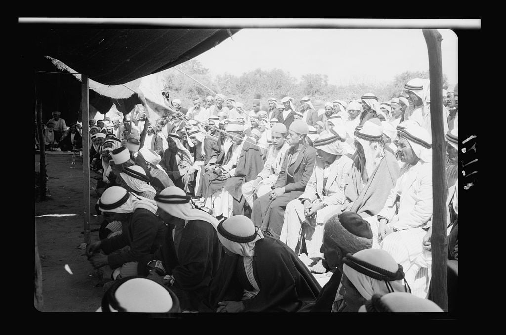
Posted by ابو عمر - صلح عشائري 1943
Posted by ابو عمر - صلح عشائري 1943
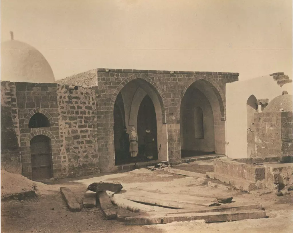
Posted by ابو عمر - الجامع قبل النكبة
- خارطة تُظهِر الحدود والطرق بأنواعها والأماكن المقدسة والطبيعة الطوبغرافية من تلال وسهول ومنحدرات والتشكيلة الطبيعية للأرض وأنواع المزروعات. نُشرت الخريطة فترة الانتداب البريطاني، تم إضافة تعديلات عليها من قِبَل خدمة الخرائط والصور التابعة للقوات العسكرية الاسرائيلية فترة الأربعينيات.
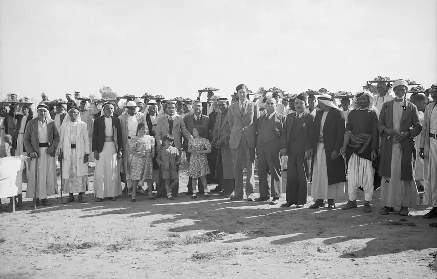
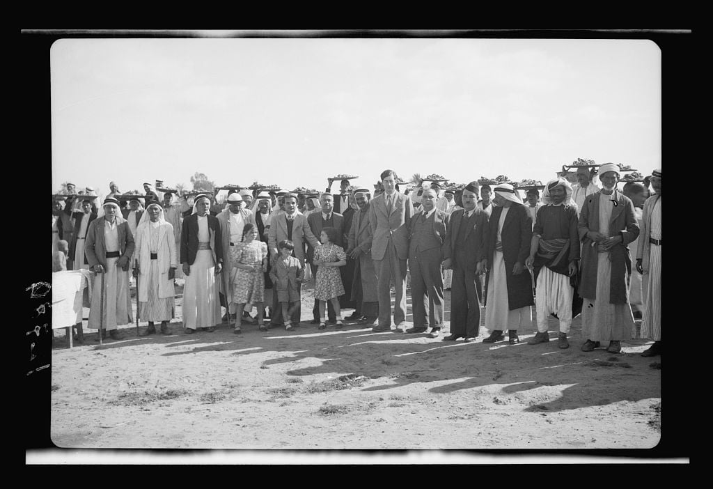
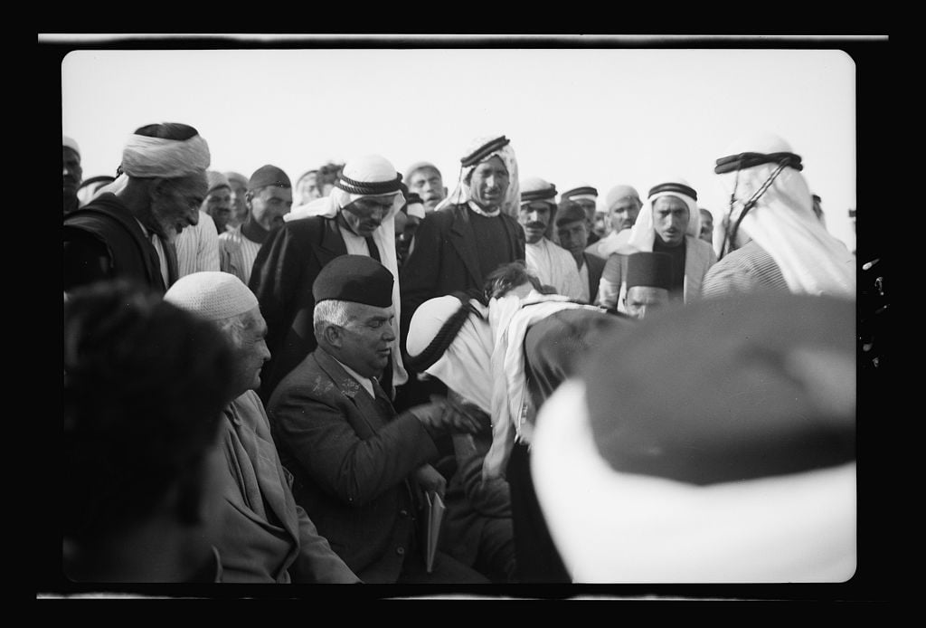
- People of Hamama with Governor Aref al Aref and the 2nd Earl of Oxford and Asquith, in 1943
Want to browse more? 80,000 pictures were grouped in these gallaries:
| Display Name | Clan/Hamolah | Country of Residence |
| Eman Hany | أبو هاني | القليوبية, مصر |
| Emad AlDaqsha | Al-Masri | Gaza Strip, Gaza Strip |
| Basil Ezzeddin | أبو عرقوب | - |
| النورس المهاجر | عزام | - |
| Reem Owda | بني كلاب , ال أبوعودة | Gaza , Palestine |
| ALI Shehada | شحادة | - |
| MHMD-MUH | - | - |
| Wesam Izzeddin | Abo Arqoub | Abha, Saudi Arabia |
| ايمن ابو فول | كلالبه | السعوديه |
| مروان حرب | - | الجزائر |
| محمد الحجة | الحجه | جـــده, جده |
| الحجه | - | Jeddah, KSA |
| جمال علي محمد عبدالباري | عبدالباري | جدة- السعودية, السعودية |
| ابو صفيه | الشوام | جده |
| احمد عبدالباري | - | جده, السعوديه |
| Mohamed Abou samaan | al omari | vienna, austria |
| Samer Kabar | - | - |
| الهباش | الهباش | جدة, السعودية |
| اسامه عبد الباري | عبد الباري | غزه , فلسطين |
| Moneer ELalawi | ELALAWI- | Vic, Australia |
| al3sqlne | - | خانيونس |
| ايمن مقداد | مقداد | - |
| MOHAMMAD ABUFOUL | kalalbah | - |
| محمد محيسن | - | - |
| salah eldanaf | eldanaf | - |
| نبيل محمد عاشور محيسن | محيسن | مكة/المملكة العربية السعودية, مكة/المملكة العربية السعودية |
| TAMER ABDEBARI | عبدالباري | - |
| اسماعيل دحلان | دحلان | الرياض, السعودية |
| أحمد سعيد مقداد | مقداد | الرياض, السعودية |
| searcher | alnajjar | gaza, palestine |
| راويه الخواجه | الخواجه | - |
| معتصم مقداد | مقداد | الوكرة, قطر |
| نادر | hgpskd | riyadh, saudi arabia |
| أحمد شحادة | شحـــــادة | غــزة, فلسطيـن |
| hamouda | حمودة | دبي, الامارات |
| Khaled Eissa | Abu-Arquob | Gaza Strip, Palestine |
| العمري | Alomary | Manchester, UK |
| Monther Abusultan | Abu Sultan | MT, USA |
| Moh'd | Kalalba | Slovakia EU |
| Muhannad AboSultan | AboSultan | Slovakia |
| Mohd_Miqdad | hamama | Jordan, Jordan |
| ali miqdad | - | amman, jordan |
| Bader Elshareif | Shareif/Khawaja | - |
| Abu Riala | Aburiala | gaza, Palestine |
| gehan | alkoka | egypt |
| Eyad Radwan | - | Tayef, Saudi Arabia |
| Mohammed dahman abusultan | abualwalid | sweden, sweden |
| ALI ALKOKA | KALALBEH | TN, USA |
| nidal | awad | - |
| Islam Inshassi | inshassi | amman, Palestine |
| Obai Radwan | Radwan | Abu Dhabi, UAE |
| Ayman Abu-Nabhan | Kalaleba | Riyadh, Saudi Arabia |
| Ahmad Kaoud | - | - |
| ALI LARKEM | - | ALGERIA, ALGERIA |
| Hatem Ezz Eddin | Abu-Arqoub | Abha, KSA |
| Ahmed Abu Safia | Shwam | Quebec, Canada |
| Hassan Shaaban Abu Sultan | Abu Sultan | Gaza, Palestine |
| Yaser Ezz Eddin | Abu Arqoub | Riyadh, Saudi Arabia |
| Abu Saleh | Shehada | Egypt, Egypt |
| muhdi | Enshassi | - |
 Fake Valor: Why Did Zionist Jews Hoist Nazis Flag on Their Ships in the 1930s?
What is new?
-
Facts About Oct. 7th Gaza Raid
-
Remined Us Please:: Who Did Rape Who? Palestinians Raped Israelis? Or, was the other way around?
-
When Prof. Edward Said was invited to debate Bibi Netanyahu in the 1980s, watch what happened!
-
Ezra Klein of the NY Times on the "Jewish Race".
-
Abusing Blood Libel!
-
Did Israeli Soldiers Activate The Hanniba Direective On Oct. 7th? You Be The Judge
-
Zionist FAQ: Isn't it true that Palestinians don't want peace? Palestinians never accepted the two-state solution
- Facts about Haavara (Transfer) Agreement between Ben-Gurion & Hitler
-
Haavara FAQs: Why Did Zionist Jews Hoist Nazis' Flags on Their Ships in the 1930s?
- Haavara FAQs: When Chaim Weizmann met FDR in mid-1943, why was he silent about rescuing European Jewry?
-
Dear ChatGPT: How did Palestinians resist Napoleon's invasion of their country in 1799?
-
Dear ChatGPT: Gaza had a vibrant Jewish community in the mid-17th century. What happened to them?
-
Dear ChatGPT: Why did the Jewish Agency suppress news of the Holocaust during WWII?
-
Video Playlist: Jews share their DNA tests to end the conflict for good.
-
A Tale of Two Conflicts: Examining the Definition of Genocide
-
Prof. Abraham Polak And The Suppressed History of the Khazars and European Jewry
-
How Ronald Reagan would have framed the genocide in Gaza if he were still alive?
-
Haavara FAQs: Let us do the math: how many German Jews did The Haavara Agreement save?
-
Zionist FAQs: The Hebron Massacre of 1929, "clearly proves" that Palestinians are antisemitic, how could you deny it?
-
Zionist FAQs: Why Anti-Zionist Is Not Antisemitism?
-
Zionist FAQs: Isn't it true that the KGB created Palestinian Nationalism in the early 1960s?
- Zionist FAQs: Muslims are killing Muslims all the time; why are Israeli Jews being singled out in the media?
- Zionist FAQs: How is Israel an apartheid state when 20% of its citizens are Arabs who enjoy full rights?
-
Haavara FAQs: Why Did Dorothy Thompson Flip From A Zionist Advocate to A Silenced Dissenter?
-
Haavara FAQs: Analysis of Herzl's Uganda Scheme and how it could have saved millions of Jews.
-
Haavara FAQs: Why did Hayim Greenberg describe American Jewry as "morally bankrupt" in early 1943?
-
Haavara FAQs: What if the Evian Conference was a resounding success? What would have been the impact of saving European Jewry on Zionism?
- Haavara FAQs: What if the six million were saved, how that would have impacted the Zionist project?
-
Haavara FAQs: How did Zionist leaders react when Europe's Jews lingered in the DP camps after WWII ended?
-
Why does the American Jewish community repeat lies that David Ben-Gurion had debunked before he died?
-
Who has the power to rename the Tatar/Khazar Gene Marker to Jewish IV?
-
Zionist FAQs: Why won't Egypt, Syria, and Jordan take their people back? Jews are indigenous to Palestine, and Arabs immigrated after Jews developed the country. Arabs should leave.
-
Haavara FAQs: Did Hitler and the Nazis conflate between Judaism and Zionist? If that wasn't case, then why?
-
Haavara FAQs: Winston Churchill and antisemitism, a collection of articles written Churchill.
-
Haavara FAQs: Broken by country, how many Jews survived vs. killed during the Holocaust?
-
Haavara FAQs: Why did European Jews vote with their feet and to immigrated to the Americas, not Palestine, after WWII?
-
Watch this American Jewish Girl describing Israeli Jews' cognitive dissonance like no other in under two minutes
-
Haavara FAQs: When the Nazis went out of their way to hide the Holocaust, Israeli Jews did the exact opposite by broadcasting their genocide of Gazans. But why?
-
Haavara FAQs: How Zionist Jews went out of their to show their appreciation to Nazism and Fascism?
- Haavara FAQs: Why Zionist leaders were against bombing the death camps & the Railroads leading to them?
-
Haavara FAQs: Hitler's message to the British and American people: If Jews are such noble citizens and you care about them, how come you're not letting them in? I will gladly ship them to you at my expense, even on luxury liners!
-
A shortlist of Zionist and Israeli false flag operations in the name Jews.
-
The Most Moral Army
- The Land of Kapos (Israel): Where the brave are boycotted and Kapos walk free.
- Why did early Zionists often named their communal enterprises "colonial"?
- Zionist Relations with Nazi Germany by Faris Glubb
-
Two NY Times advertisements by Zionists in the early 1943 that exposes Zionists' treason at the height of the calamity
- Facts Not Lies about the Palestinian-Israeli Conflict.
- Site's pictures have been categorized
- Campgain Against Lice
- A Survey of Palestine, the official source about Palestine before Nakba produced by the British Mandate; over 1200 pages.
- Satellite View & Google Earth: Over 6,000 placemarks identifying all destroyed towns, W. Bank & Gaza Strip Towns, & refugee camps.
- PalestineRemembered.com and its Nakba Oral History Project were featured on al-Jazeera Satellite TV.
- Nakba Oral History Video Podcast:
 Over 700 Oral History interviews (including 3,500+ hours of recording) can be viewed online.
 - Palestine Village Statistics Project
- Gaza Jail Break
- النسخة العربية للموقع الان متوفرة
- Videos: Documenting the destroyed villages in video: Tracing all that remains since Nakba.
- Videos: Responding to Zionist Propaganda
- Interview: The ethnic cleansing of Palestine: George Galloway interviews Israeli Historian Ilan Pappe.
- For Palestinians, memory matters. It provides a blueprint for their future By George Bisharat.
- Zionist FAQ now available in Hebrew שאלות שציונים שואלים, עכשיו בעברית
- Video: The Stephen Walt and John Mearsheimer report on the influence of the Israel Lobby on U.S. Foreign Policy
- The Palestinian-Israeli conflict for beginners
